


Abstract
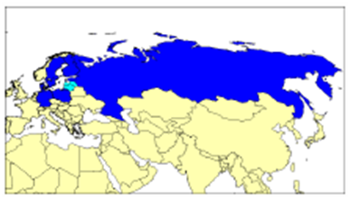
The Baltic Sea Hydrographic Commission (BSHC) was established in 1982 as an IHO Regional Commission. The BSHC Members are the Hydrographic Offices of Denmark, Estonia, Finland, Germany, Latvia, Poland, the Russian Federation and Sweden. Lithuania is an Associate Member (Figure 1). The BSHC foster and coordinates hydrographic Activities on the Baltic Sea area. The Baltic Sea is environmentally sensitive quite closed sea area with intensive passenger, oil and cargo shipping. All Baltic Sea Countries are actively participating in the BSHC work. This paper gives an overview of the BSHC activities and co-operation on hydrographic issues with other Baltic Sea Organisations.
The Baltic Sea
The Baltic Sea is almost a closed sea area. It is connected to the North Sea via the Danish Straits. The minimum navigable depth is about 18 m which limits the maximum draft of the ships entering the Baltic Sea to 16.4 m and the recommended draft to 14.5 m.
The area of Baltic Sea is roughly 400.000 km2. The Baltic Sea is relatively shallow, its median depth is about 43 m and mean depth is about 54 m. About 20% of its area is less than 15 m which create potential obstacles for navigation. About 70% of its area has depths less than 70 m which may influence the fuel consumption of ships. For comparison the mean depth of the North Sea is about 90 m and the mean depth of Mediterranean Sea about 1500 m.
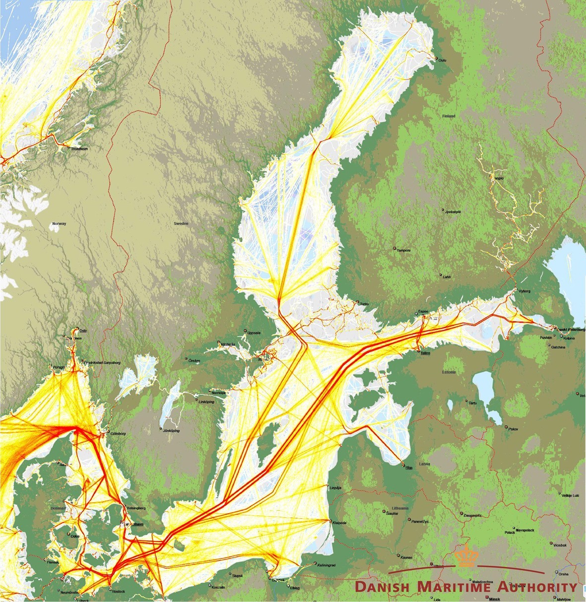
The Baltic Sea is an environmentally sensitive area due the facts that it has brackish waters, the shores are heavily populated and widely used for a broad range of activities. Shipping is very dense on the Baltic Sea. There are intensively used passenger, oil and cargo routes (Figure 2). In 2005, the IMO approved the Particularly Sensitive Sea Area (PSSA) status to Baltic Sea (except Russian waters).
There is no remarkable tide on the Baltic Sea; however there are remarkable irregular water level variations due to weather conditions. Large parts of the Baltic Sea are covered by ice during winter time. In the Northern part, there is remarkable land uplift due the previous glacial period.
Baltic Sea Hydrographic Commission (BSHC)
Members: Denmark, Estonia, Finland, Germany, Latvia, Poland, Russian Federation, Sweden.
Associate Members: Lithuania.
Brief History. The BSHC was established in Helsinki, Finland, on 24-26 May 1983 following a recommendation made by the Hydrographers of the Baltic Sea at a preliminary meeting in Monaco on 19 April 1982. The original initiative came from Sweden and the first Chairman was Commodore Folke Hallbjörner (Sweden). The initial activities were to agree on the BSHC Statutes, to establish the Baltic Sea INT Chart Committee, to discuss the Baltic Sea bathymetric charts, the differences between Baltic Sea coordinate systems, the distribution of printed charts, limits of territorial seas, the Baltic Sea Radio Navigational Warning system, and the IHO technical assistance programme. First Statutes were approved in May 1983. The latest version is approved in June 2007.
The main achievements have been the coordination of the production of the Baltic Sea INT Charts, the coordination of hydrographic re-surveys, harmonization of chart datums, harmonization of Baltic Sea ENCs, and the exchange of information and the harmonization of practices with regard to various issues related to hydrography.
BSHC has its Conferences at least bi-annually. However during the last years there have been so many activities that the Conferences have been held every year. There has been 19 BSHC Conferences up to now.
BSHC Main Activities
Below are briefly listed the BSHC Working Groups with their main activities. All BSHC Full and Associate Members are actively participating and contributing to these Working Groups. The activities within the Commission have increased and recently the BSHC has had its Conferences every year.
Baltic Sea INT Chart Coordinating Working Group (BSICCWG) coordinates the development and the updating of the Baltic Sea INT Chart Scheme. In addition the BSICCWG coordinates Baltic Sea ENC harmonisation actions. There is a separate Note on some of the BSICCWG activities in this IHR edition.
BSHC Re-survey Monitoring Working Group (MWG) has developed and updates the Baltic Sea Re- survey Scheme. The Re-survey Scheme covers the whole Baltic Sea and includes prioritized re-survey plans with time schedule estimations for areas used for navigation. This activity is endorsed and highly appreciated by HELCOM. There is a separate Article on the Re-survey Scheme in this IHR edition.
Chart Datum Working Group (CDWG) has fostered the harmonisation of Baltic Sea vertical references. The CDWG has proposed to IHO TWLWG to revise IHO resolution on vertical datums to better reflect the non-tidal and inland waters (IHO Resolution 3/1919 as amended). The CDWG has evaluated the needs and possibilities to move on a harmonised vertical reference. BSHC has agreed in principle to move EVRS. CDWG is developing a Road Map to this transition by 2020. CDWG is establishing a closer co-operation with Baltic Sea Oceanographic Observation System (BOOS). There is a separate Note on CDWG activities in this IHR edition.
Baltic Sea Bathymetric Database Working Group (BSBDWG) has developed the Baltic Sea Depth Model. The Depth Model has flexible resolution because the density of thee source data varies much. Also some countries have restrictions to deliver high density data. The Depth Model has been released Autumn 2013 and is available via the BSHC web site. The Model has been well received by quite wide variety of users. There is a separate Article on the Baltic Sea Depth Model in this IHR edition.
Baltic Sea Marine Spatial Data Information Working Group (BSMSDIWG). This Working Group works closely together with the HSSC MSDIWG. Currently both Working Groups have the same chair. The intention is to give Baltic Sea regional input to the HSSC MSDIWG. There is a separate Note on some of the BSMSDIWG activities in this IHR edition.
In addition to these Working Groups, the BSHC has a representative to IHO IRCC WENDWG and to IHO-EU Network. BSHC has also endorsed other co-operation activities, e.g. a LIDAR seminar in May 2014.
BSHC co-operation with HELCOM
The BSHC has a close connection to the Baltic Marine Environmental Protection Commission (known as the Helsinki Commission and abbreviated HELCOM), the governing body of the Convention on the Protection of the Marine Environment of the Baltic Sea Area. This Convention was originally signed by all coastal countries in 1974 and ratified 1980. Since the revised convention 1992 the Contracting Parties are Denmark, Estonia, the European Union, Finland, Germany, Latvia, Lithuania, Poland, Russia and Sweden. The Convention is also the legal mandate of HELCOM and its maritime related working groups. Safety of navigation was included early on in the work of HELCOM as can be seen from the Resolutions 3 “Navigation of Commercial Ships Through the Entrances to the Baltic Sea” and 5 “Safety of navigation”, adopted with the Convention in 1974.
In addition to the Commission itself, HELCOM has five main sub-groups with annual meetings, where the MARITIME Group deals with issues related to pollution from shipping and safety of navigation. RESPONSE deals with preparedness and response to accidents at sea and on the shore. HELCOM convenes at the level of ministers approximately every 3 years. Usually Ministers of Environment attend at the Ministerial level, but Ministers of Transport have also convened under HELCOM, and transport agencies attend the HELCOM MARITIME group.
Since the beginning of the cooperation, the contracting states have been aware of the close relationship between the availability of reliable nautical charts and safety of navigation and prevention of pollution of the Baltic Sea as called for by the Helsinki Convention. The work of the hydrographers of the Baltic Sea region and particularly the IHO Baltic Sea Hydrographic Commission (BSHC), also established in Helsinki in 1983, has been one instrumental factor in delivering safer navigation in the Baltic Sea.
The production of more reliable nautical charts (paper as well as electronic), is in many cases only possible through costly re-surveys. However, accidents like the 2001 ”Baltic Carrier” have demonstrated the cost-efficiency of these investments in the densely trafficked Baltic Sea. Even if the region has developed a high level of preparedness to pollution incidents since the 1970s, the heavy traffic and size of modern ships is a strong incentive to invest in improving safety of navigation in the region (Figures).
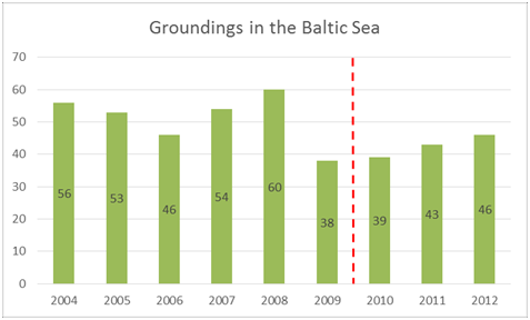
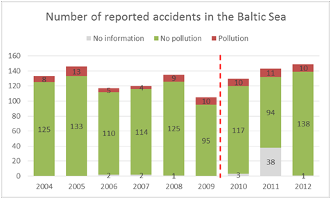
(HELCOM 2014, Report on shipping accidents in the Baltic Sea area during 2012).
As a reaction to the Baltic Carrier accident the Declaration on the safety of navigation and emergency capacity in the Baltic Sea area (HELCOM Copenhagen Declaration), adopted on 10 September 2001 in Copenhagen by the Ministers of Transport of the Baltic Sea region, agreed to measures on Re-surveying of major shipping routes and ports (IIIa):
“requesting the Governments of the Contracting Parties to develop a scheme for systematic re-surveying of major shipping routes and ports in order to ensure that safety of navigation is not endangered by inadequate source information. The survey shall be carried out to a standard not inferior to the latest edition of IHO S-44. The scheme shall be elaborated jointly by the hydrographic services responsible for the areas in question not later than by the end of 2002 with the aim to begin implementation by 2003”
The national hydrographic offices of the region, working within IHO BSHC, developed, approved and commenced implementation in 2002, the regional Harmonised Hydrographic Re-Survey Plan according to estimations of the main routes used by the ships. The HELCOM maritime related working groups on prevention of pollution and safety of navigation were updated along the way.
The 2001 Declaration on the safety of navigation and emergency capacity in the Baltic Sea area (HELCOM Copenhagen Declaration) requested Baltic Sea Hydrographic offices to present a systematic scheme for re-surveys to major routes and ports in order to ensure that safety of navigation is not endangered by inadequate source information. The same Declaration also established the regional HELCOM AIS system, operational since 2005, which is administered and developed by the HELCOM AIS EWG. The regional AIS system has provided information on the tracks of shipping in the Baltic Sea which has helped influence prioritization of re-survey activities.
The Moscow 2010 Ministerial Declaration extended the scope to cover the whole Baltic Sea and to have time schedules for re-surveys for areas used mainly for shipping. HELCOM-BSHC Harmonised re-survey Scheme was approved by BSHC 18th Conference in 2013 and adopted by the HELCOM Copenhagen 2013 Ministerial meeting.
The progress of the regional re-survey Scheme has been reported annually to the MARITIME meetings. In addition, information on other Baltic Sea hydrographic activities has been given. Other cooperation between HELCOM and hydrographic offices include the Mariners’ Routeing Guide Baltic Sea which presents routeing and other safety of navigation related information in chart form, published by the Bundesamt für Seeschifffahrt und Hydrographie (Germany) but originally agreed within the HELCOM expert group on safety of navigation.
Within HELCOM, the hydrographic activities have been recognised as highly valuable for enhancing safety of navigation and reducing the risk of grounding and accidental pollution in the region. Hydrogra- phy is also recognised as central in order to produce basic bathymetric data, useful for many applications beyond the safety of navigation. HELCOM has provided continuous political support to hydrographic activities to BSHC members.
The high quality hydrographic data resulting from the extensive implementation of these commitments over the last decade has many interesting, and important uses beyond the field of safety of navigation. These include Maritime Spatial Planning, with issues like finding good locations for wind power installations or marine parks, as well as geographic modelling of the distribution, and quality status of underwater life.
More openly accessible hydrographic data products for such non-navigational use in the Baltic Sea region, as indicated by the recent BSHC bathymetry database, would help the implementation of numerous regional commitments related to the marine environment and the development of GIS data with bathymetric components.
Currently ongoing HELCOM work in the field of safety of navigation includes the development of regional recommendations on Under Keel Clearance and implementing a recent Recommendation on e-navigation, both topics which are depending on high quality bathymetric data.
Baltic Sea cooperation between HELCOM and BSHC, in the intersection between environment, safety of navigation and hydrography has always been exciting. Lets make it even better!
More information on HELCOM and its activities can be found at: http://helcom.fi/
BSHC co-operation with the EU Strategy for the Baltic Sea Region (EUSBSR)
The European Union Strategy for the Baltic Sea Region (EUSBSR) was adopted in 2009 as the European Unions first so-called macro-regional strategy. The Strategy aims to:
- Save the sea
- Connect the region
- Increase prosperity
The strategy is divided in thematic Priority Areas, The overall goal of the Priority Area on Maritime Safety and Security is for the Baltic Sea Region “to become a leading region in maritime safety and security”. This objective is implemented by means of policy dialogue and flagship projects. These projects cover a wide range of aspects of maritime safety and security, such as e-Navigation, navigation in icy waters, safety in fisheries, transport of dangerous goods, re-surveying of shipping routes as well as the fostering of innovation and initiatives towards creating a common information sharing environment for maritime security information.
Denmark and Finland serve as Priority Area Coordinators for the Priority Area on behalf of the other eight EU Member States around the Baltic Sea. The task is jointly headed by the Finnish Transport Safety Agency and the Danish Maritime Authority. An international Steering Committee has been established to guide and assist the Priority Area Coordinators in their work. The Steering Committee consists of members from maritime authorities in the Baltic Sea States, regional organisations, the European Commission and other relevant stakeholders, which all attend its meetings.
The Priority Area on Maritime Safety and Security includes the Flagship Project entitled “Speed up re-surveys on major shipping routes and ports”. Through its Flagship Project status, the HELCOM-BSHC Harmonised Re-survey Scheme gains political support and visibility. The project reports on the progress of its activities biannually. Many of the nautical charts of the Baltic Sea are partly based on inaccurate surveys up to 100 years old, where the depth information is often based on handmade lead casts.
Resurveying of the Baltic Sea with modern technology is expected to bring about a number of advantages for safer and more efficient shipping. In addition, the collected data will also be useful for other maritime applications, such as planning of wind energy or environmental protection. Lastly, it may also serve as base data for the use of the sea in fields still to be explored, and by this provide incentives for blue growth. Thus, in a Baltic Sea context, resurveying is believed to contribute to both saving the sea, connecting the region more effectively and as a means to increase prosperity.
Both HELCOM and EUSBSR have recognised the importance of hydrographic activities as a basis for the safety of navigation and numerous other maritime activities. Both organisations have given valuable political support to BSHC Members for them to schedule and finance their re-survey plans and budgets.
As a practical means to foster re-surveys there has been a successful project entitled “MonaLisa” co-funded by the EU TEN-T within the Motorways of the Seas programme. Thanks to this project extensive Finnish and Swedish sea areas have been re-surveyed with co-funding from the European Union. Another project entitled Finalising Surveys for the Baltic Motorways of the Sea (FAMOS) is being planned, in order to complete re-surveying of areas used for navigation by participating countries. A separate article on the MonaLisa project is included in this IHR issue. These projects also enjoy Flagship Project status in the Strategy.
More information on the EUSBSR Priority Area Maritime Safety and Security and its activities can be found: http://pa-safe,dma.dk and http://www.balticsea-region-strategy.eu/
BSHC co-operation with the Baltic Sea Operational Observation System (BOOS)

The aim of BOOS is to provide integrated marine services to the marine users and policy makers and to improve the safety and efficiency of maritime transport and marine operations.
The BOOS co-operation was formed in 1997 with the aim to promote and develop an operational oceanographic infrastructure including routine collection, interpretation and presentation of in situ and satellite data. This information is necessary in order to improve efficiency of marine operations, reduce risks for accidents, optimise monitoring of marine environment and climate, improve assessment of fish stocks and improve foundation of public marine management. An operational service supporting these activities shall focus on observations and model predictions, analyses and scenarios. Products of high – quality which are timely delivered to users in a sustained manner are key factors to success of services.
Modelling activities and observation system on water level uses a wide spread of reference datum. The problem occur when the user starts to compare water level data coming from many countries, for example in the Öresund area. In Denmark the reference DVR90 are used, while in Sweden the water level data are often presented relative mean sea level (MSL). This means that the users of water level data need to recalculate the sea level data into a common reference. In the eastern part of the Baltic, almost all stations are related to the Kronstadt datum, which is not correlated to the reference datum used at the stations in the western part, which is referred to the European Vertical Reference System which correlates to Normaal Amsterdam Peil (NAP). The difference can be of several dm.
BSHC and BOOS have worked together on issues related to water level observations, predictions and harmonisation issues. Both are fostering actions for harmonisation of vertical references. Since, 2012 BOOS has started to present the relationship between the presented water level value and known reference datum to the users. The common reference datum BOOS are working towards is the European Vertical Reference Frame. The information can either be found inside the data files distributed in the BOOS Data Portal or can be found in a pdf-file, which can be found here:
http://www.smhi.se/hfa_coord/BOOS/dbkust/mwreg_boos.pdf
More information on BOOS and on its activities can be found: http://www.boos.org/.
Discussion
All Baltic Sea Countries are participating and contributing actively to the work of the BSHC and its Working Groups. Also Lithuania is active, even if it is not an IHO Member State, but an Associate Member to BSHC.
The co-operation between these organisations is constructive and friendly and results are considered fruitful. All of these organisations aim to enhance safety and efficiency of navigation on the Baltic Sea and thus also support the protection of the marine environment.
The outcomes of these efforts are regarded to be beneficial for numerous activities of the societies. Major progress in many issues has been achieved. Good practises have been identified, shared with others and taken into use on the Baltic Sea.
Biographies
Juha Korhonen has been working at the Finnish Hydrographic Office since 1974. He has been involved on software and database development, coordination of different development and organisational projects, and participated to IHO work on different levels. He has MSc on land surveying n the Technical University of Helsinki.
Hermanni Backer, since 2012, works as the Professional Secretary of the Helsinki Commission responsible for groups related to Maritime activities and Response to pollution incidents at sea. During 2011-2012 he coordinated the Plan Bothnia project – a trans-boundary Sweden-Finland maritime spatial planning pilot in the Baltic Sea. He has M.Sc. (marine ecology) and LL.M (Public International Law), both from University of Helsinki, Finland.
Thomas Hammarklint is working at the Swedish Meteorological and Hydrological Institute (SMHI). Since 2003 he has been working with exchange of water level data in the Baltic Sea and is the BOOS representative in the BSHC CDWG.
Bjarke Wiehe Bøtcher is working as Chief Advisor in the Danish Maritime Authority. He serves as Coordinator for the Authority´s involvement in the EU Strategy for the Baltic Sea Region in the fields of maritime safety and clean shipping. Since 2001 he has been dealing with intergovernmental cooperation in the Baltic Sea Region.