
Abstract
1. Background and development process
Hydrographic surveys are long term activities. In the early 2000s, it was recognised that the status of hydrographic surveys of the Baltic Sea was not satisfactory. Whilst precise satellite based positioning is widely available, many areas in nautical charts are based on surveys up to 100 years old often with poor positional accuracy. Navigation with electronic charts is increasing and IMO has approved Electronic Chart Display and Information System (ECDIS) to be a mandatory navigation tool within a few years. The increasing size and speed of ships today set new requirements for chart information. In exceptional cases (e.g. ice conditions or accidents, environmental protection), there are many needs for accurate depth information also outside the main shipping routes. Thus there are clear needs for re-surveying the areas used for shipping with modern technology.
Following a serious tanker incident in March 2001 on the southern Baltic Sea, an ad-hoc Expert Group of the HELCOM was established to evaluate possible means to avoid this kind of accidents and to prepare a Minister level meeting to be held on 10 September 2001. This group proposed e.g. to achieve full Electronic Navigational Chart (ENC) coverage by 2004, a recommendation to promote the use of ECDIS, and to foster hydrographic re-surveying on the Baltic Sea.
At the BSHC 9th Conference June 2001, the need for re-surveys was recognised. Noting the increase in deep draft ship traffic and the increase of the size of ships and the vulnerability of the marine environment in the Baltic Sea, the BSHC 9th meeting in June 2001 adopted the recommendation: recommended that areas of concern to be re-surveyed at a regular basis in accordance with the highest standard set by the latest edition of IHO S-44. The re-survey should be based at a scheme elaborated jointly by the hydrographic services responsible for the area in question, (BSHC, 2001).
The HELCOM Copenhagen 2001 Ministerial Declaration was adopted on 10 September 2001 by the HELCOM Extraordinary Ministerial Meeting (HELCOM, 2001a). It was included into the HELCOM Convention entering into force on 1 December 2002 (HELCOM, 2001b). The Copenhagen Declaration 2001 requests the following:
a) Re-surveying of major shipping routes and ports
by requesting the Governments of the Contracting Parties to develop a scheme for systematic re-surveying of major shipping routes and ports in order to ensure that safety of navigation is not endangered by inadequate source information. The survey shall be carried out to a standard not inferior to the latest edition of IHO S-44. The scheme shall be elaborated jointly by the hydrographic services responsible for the areas in question not later than by the end of 2002 with the aim to begin implementation by 2003.
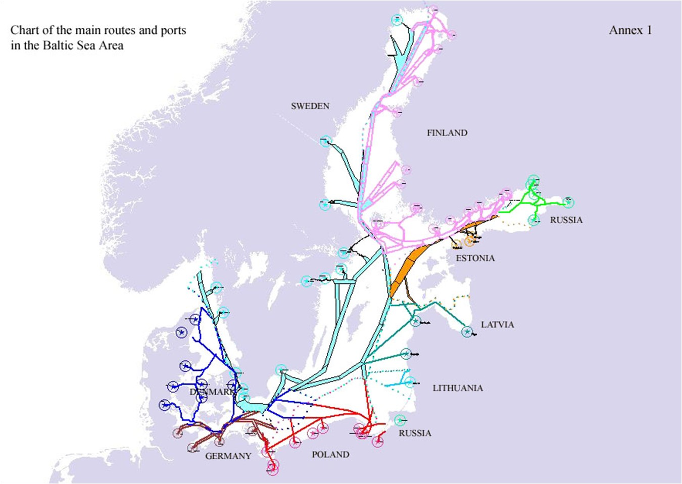
The BSHC established the Re-survey Monitoring Working Group (MWG) to develop the Harmonised Hydrographic Re-Survey Scheme. There were no fixed time schedules for these re-surveys. Each country specified the primary and secondary routes and ports in its area of responsibility. Originally these routes were based on the list of main ports used as a background document for Copenhagen Declaration (HELCOM, 2001c). See Figure 1. These routes and areas are included in the re-survey database. [Later on some of the routes and areas have been updated and extended by the MWG members. These areas are later referred to as Category I areas]. The BSHC approved Version 1.0 of Harmonised Hydrographic Re-Survey Plan in December 2002. This was widely communicated i.e. via a press release as included in IHO CL 12/2003 (IHO, 2003).
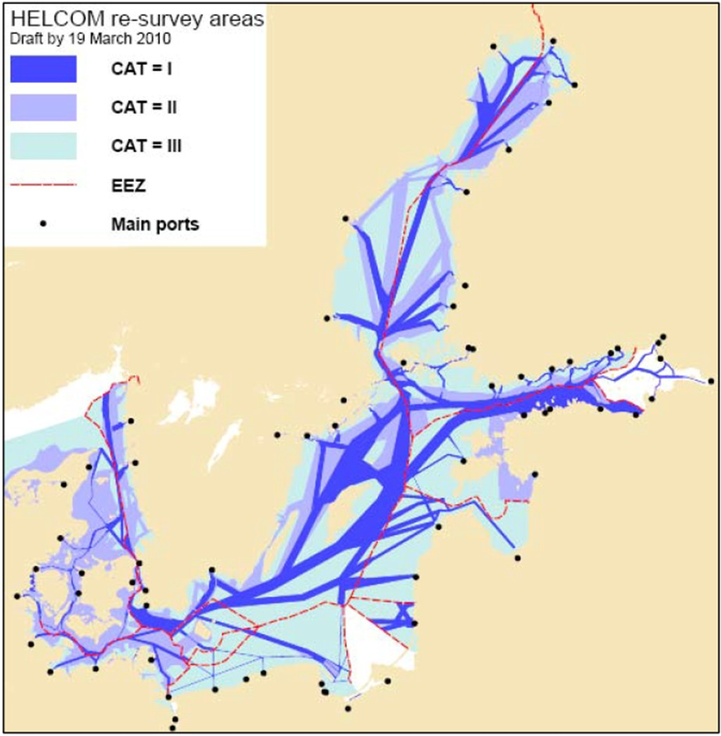
BSHC Vision 2009. Since 2002, it has been realised that the original scheme needs to be revised, e.g. new routeing measures approved or planned, there are recognized high priority areas outside original routes, Automatic Identification System (AIS) data enables accurate tracking of ship routes, and needs other than safety of navigation. The BSHC 14th Conference in 2009 approved a new Vision for revised re-survey scheme to extend the original scheme to cover the whole Baltic Sea area. The re-survey areas (see Figure 2) are categorized into three Categories: CAT I for original re-survey scheme, CAT II for extension needed for the safety of navigation, and CAT III for areas to be re-surveyed for other reasons than safety of navigation (e.g. for environmental purposes).
The HELCOM Moscow 2010 Ministerial Declaration agreed to extend the scope of the HELCOM Copenhagen Declaration and present time schedule estimations for re-surveys. The Moscow Declaration 2010 and its supporting documents can be found in references (HELCOM, 2010a), (HELCOM, 2010b) and (HELCOM, 2010c). The Moscow 2010 Declaration specifically requests the HELCOM Contracting Parties (Baltic Sea States) to:
– Develop the Revised Baltic Sea Re-survey Scheme to cover the whole Baltic Sea according to the BSHC 2009 Vision
– Include CAT I and II re-surveys to cover all routes and other areas used for navigation
– Include CAT III re-surveys for other areas than for safety of navigation purposes (e.g. environmental)
– Specify time schedule estimations for CAT I and II re-surveys
– Present their national re-survey plans preferably by 2013, but not later than 2015
– Undertake necessary measures to ensure that sufficient funding, including external funding, will be available for the re-surveys
– Undertake measures to improve mariners’ abilities to assess and interpret hydrographic content in nautical charts and publications either in printed or digital form, especially in the Electronic Chart Display and Information System
Autumn 2012, the BSHC reported that the Revised Re-survey Scheme is already quite complete and proposed to report the status of its implementation to the HELCOM Ministerial Meeting on 3 October 2013. The BSHC also emphasised that hydrographic surveys provide useful information for several sectors in society.
The HELCOM Ministerial Meeting on 3 October 2013 (HELCOM, 2013a) adopted the Baltic Sea Harmonised Re-survey Scheme. The Ministerial Declaration and the Supporting Document of the Ministerial meeting are available at HELCOM web sites. The 2013 Ministerial Declaration ADOPTED the Re-survey Scheme as:
– HELCOM-BSHC Harmonised Re-Survey Scheme 2013 (HELCOM, 2013b), with time schedule estimations and funding arrangements, bearing in mind that these are likely to be modified when new national needs or priorities arise;
The Ministers “ FURTHER AGREED the following specific approaches and measures” and under titles Shipping and activities at sea and Safety of navigation on page 15 there are 14(M) and 15(M) including actions to ensure the completion of re-surveys.
Finally, WE AGREE to fully implement the 2007 Baltic Sea Action Plan [BSAP] by 2021. With this Declaration with its general and specific approaches, actions and measures WE FURTHER AGREE to step up efforts for further strengthened implementation of the BSAP WE NOTE WITH APPRECIATION the following further general and specific approaches, actions and measures. WE WILL continuously REVIEW and REPORT how these commitments are implemented.
14 (M). RECALLING the HELCOM Copenhagen 2001, Krakow 2007 and Moscow 2010 commitments on hydrographic re-survey and COMMENDING WITH APPRECIATION the subsequent substantial progress made in systematic re-surveying of major shipping routes and ports in the region according to the HELCOM-BSHC Re-survey Scheme aimed at ensuring that safety of navigation in the Baltic Sea region is not endangered by inadequate source information;
15 (M). WE AGREE to take actions to ensure the completion of the re-surveys for areas used by navigation (CAT I and II) within the time schedules estimated in the 2013 Re-survey Scheme, to promote wider use of accurate and reliable depth information by e.g. developing existing and/or new products including an enhanced and freely accessible Baltic Sea Depth Model, and to foster CAT III re-surveys of other areas not primarily for safety of navigation purposes, e.g. for environmental protection;
The supporting document HELCOM-BSHC Re-survey Scheme is regarded to be a part of the 2013 Ministerial Declaration. This document includes the time schedule estimations for completing resurveys for CAT I and II, which are referred to in the Declaration. The statistics are based on the status of late August 2013. The situation has already changed due to updates in the re-survey database. Updated statistics could be created when needs arise.
The Re-survey Scheme, the status of re-surveys and future plans have been reported together with some other hydrographic co-operation activities annually to HELCOM MARITIME Group. MARITIME highly appreciates the BSHC work and co-operation for increasing safety of navigation on the Baltic Sea and thus reducing risks for accidents and pollution.
The European Union Strategy for the Baltic Sea has an Action Plan which includes the Flagship project “Speed up re-surveys of major shipping routes and ports” within the Priority Area on Maritime Safety and Security (EUSBSR, 2013). The development of the Re-survey Scheme and progress of the re-surveys have been reported biannually to the Steering Committee of this Priority Area. The Steering Committee appreciates this activity and endorses the future plans.
2. Main principles of the harmonised Re-survey Scheme
In 2002 the BSHC Re-survey Monitoring Working Group (MWG) agreed to some practical, basic principles for developing the re-survey scheme and re-survey database. Later on slightly updated and extended principles are listed below:
Responsibility of the development and implementation of the Scheme. Each Baltic Sea Hydrographic Office (HO) is responsible for developing and implementing their National Re-survey Plans in its area of responsibility. The composition of National Plans will form the Baltic Sea Harmonised Re-survey Scheme. Necessary co-operation between the HOs will be discussed in bilateral negotiations and agreed on Bilateral Arrangements.
Role of National Re-survey Plans. The BSHC has a common understanding that even if the re-survey Plans will be approved by the BSHC and adopted by HELCOM, these plans are not fixed.
They are likely to be modified when new needs or priorities arise.
General Principles for the Re-survey Scheme. This Scheme has been prepared according to the following General principles:
– This Scheme will concentrate only on the hydrographic surveys.
– Common understanding of the HELCOM Copenhagen Declaration is: All routes are to be re-surveyed, if the old survey data cannot be interpreted according to the IHO S-44 standard.
– For CAT I and II the new IHO S-44 Ed.5 will be applied in future surveys with the principle that where Order 1 survey is required, the survey should fulfil new Order 1a requirements.
– Each country is responsible for the interpretation of the IHO S-44 and compliance of its data regarding its own surveys.
– The main and secondary routes and ports are defined mainly by the traffic volumes of dangerous goods and passengers.
– As a general guideline the width of the routes in coastal areas should be at least two nautical miles; for open sea areas 6 nautical miles. The actual width of the routes and areas will be described in the Scheme.
– The S-44 feature detection requirement for Order 1a up to 40 metres should be interpreted bearing in mind the maximum draft of the Danish straits.
Prioritized time schedules of Re-surveys. Each HO is responsible for setting prioritised time schedules for re-surveys under its responsibility. Especially the following general principles should be considered:
– importance for international and regional traffic
– depth and expected shallows or obstructions
– quality and up-to-dateness of previous surveys
– importance for other uses
Harmonisation of National Re-survey Plans. There are still issues to be harmonised, e.g. differences on the width of routes and disjointed sections. All Hydrographic Offices will make necessary actions to harmonise the routes and areas between neighbouring countries. Bilateral or multilateral negotiations between the Hydrographic Offices of the neighbouring countries may be needed.
Principles of distribution of the re-surveys data. The re-survey data will be processed as soon as possible and be included in the appropriate nautical charts and products, basically to printed charts and ENCs. The quality of information on data should be transferred with the data. Other possible exchange and distribution of the re-survey data should be agreed within the Bilateral Arrangements between the HOs.
Principles of presentation of the re-survey data. Wherever possible, a common symbology (based on IHO specified symbology) for presenting re-surveyed areas on printed nautical charts should be used.
Funding of re-surveys. All BSHC Members are planning to fund their national re-surveys through their government. There are some fixed plans for some countries to complete their CAT I and CAT II re-surveys. Some countries are also using external co-funding for speeding up their re-surveys, e.g. Finland and Sweden are using European Union TEN-T co-funding. There are plans to seek future European Union co-funding for 2014 – 2020.
Implementation of re-survey plans. The BSHC has identified the following actions to ensure the implementation of National re-survey plans according to the estimated time schedules:
– All BSHC members commit to the implementation of their re-survey plans
– Seek External funding, where feasible
– The BSHC Monitoring Working Group to continue its work
Follow-up actions. The BSHC has identified some follow-up actions to monitor the implementation of the National re-survey plans, e.g. BSHC will monitor the progress of implementation at its annual Conferences and report annually to HELCOM on the progress of implementation.
3. Re-survey Database
Sweden has volunteered to develop and maintain the re-survey database and its web-based user interface. The first version was released in 2002. Some updates were made during 2003 – 2011. The latest version is Version 2 allowing to load and update the revised scheme.
Data model. The database contains metadata of the re-survey areas and the status of their re- surveys. The main object class is called Section. It represents a homogenous re-survey part of a route. The name is unique. There is only one member country responsible for each section. The geometry for the sections is stored in WGS84. The size of Section has not been limited in anyway and it is up to the operators to define it. A section has altogether 36 attributes including several internal system attributes. The main attributes meaningful to the users are: Country, Section name, Route/ Area name, Route type, Status, S-44 compliancy, Priority, Category, Length, Width, Area, Re-survey work, 6 Date attributes for planned and actual work, Remarks and Geometry. All of these could be updated via the Restricted User Interface. Some of them may be used for filtering the data on displays or database extracts.
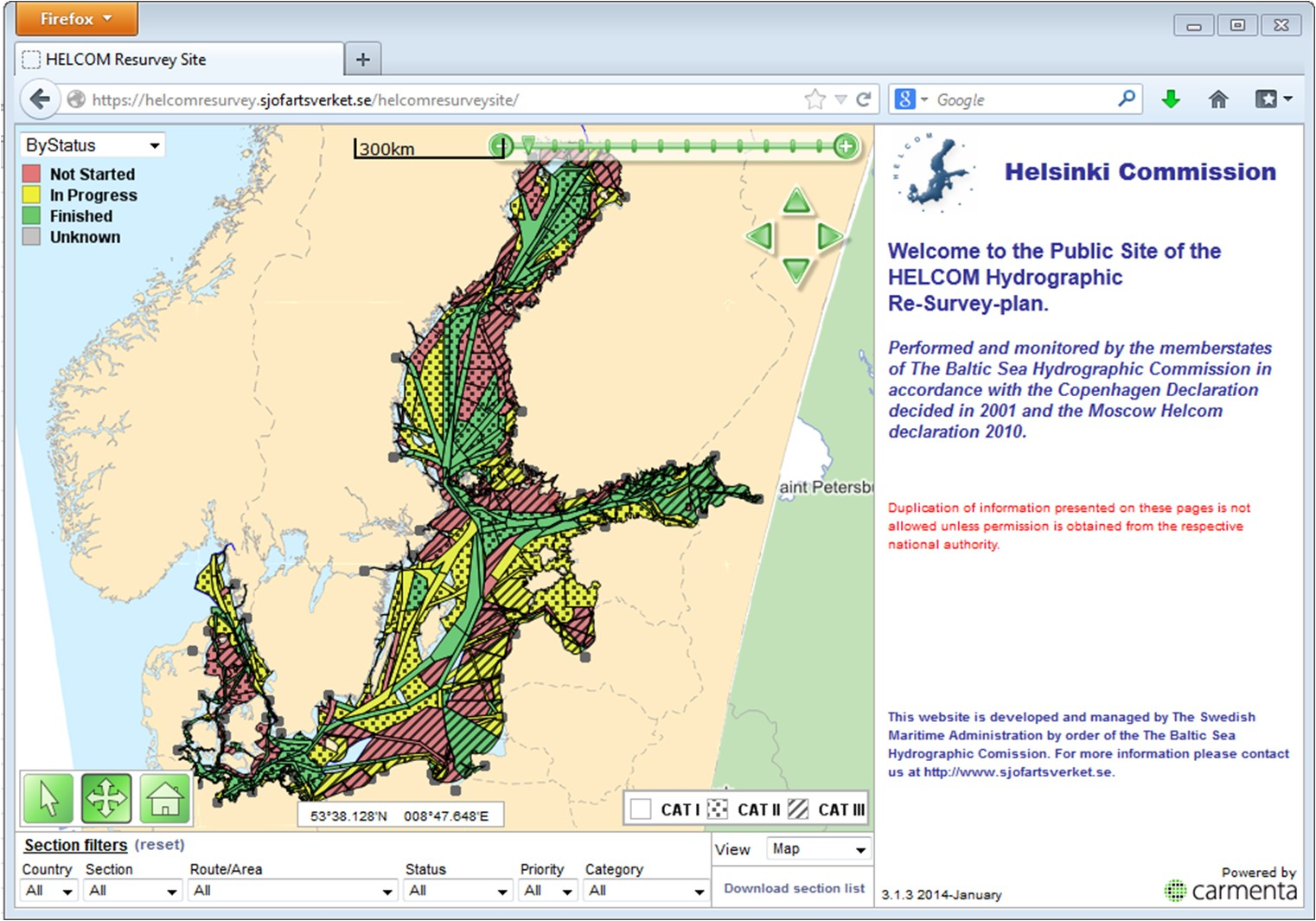
The web-based Browser Interface to the data-base (see Figure 3) is open to all via the link: http://helcomresurvey.sjofartsverket.se/helcomresurveysite/.
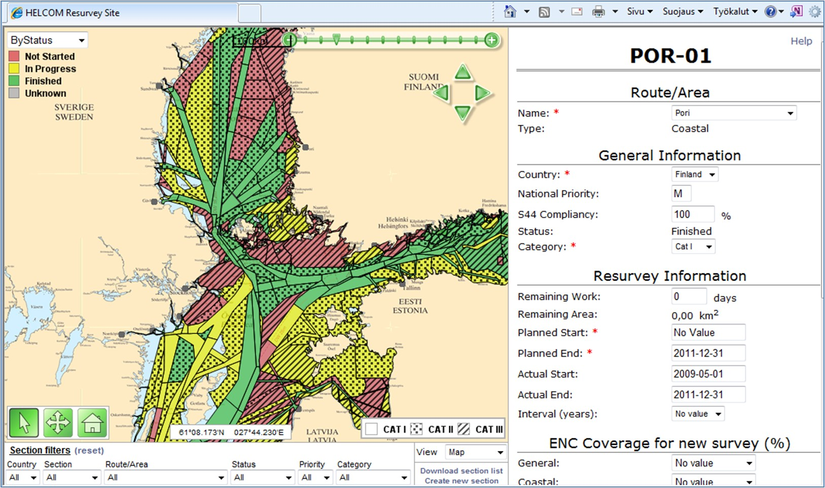
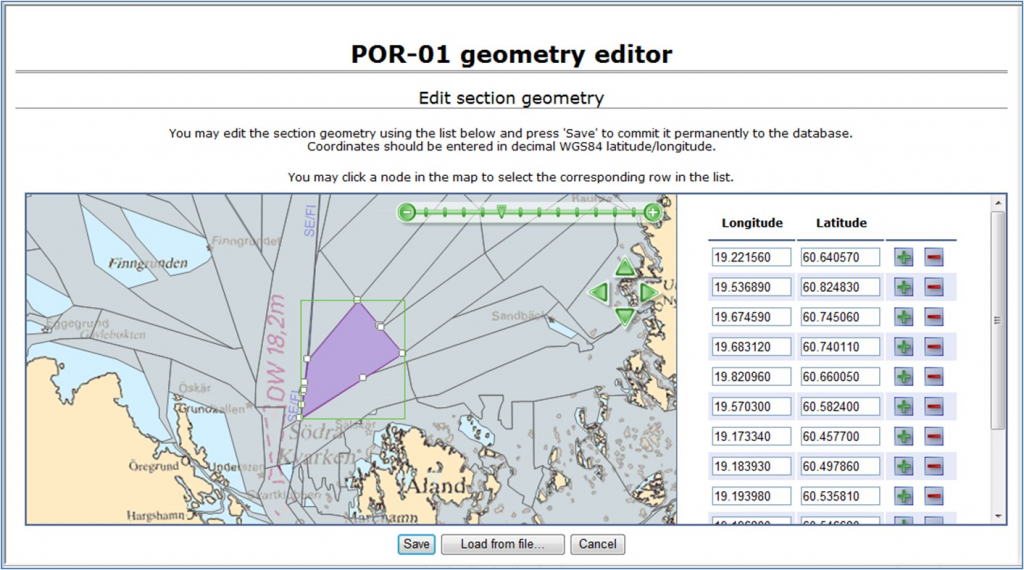
With the web-based Restricted Interface (see Figure 4) the metadata of re-survey routes and areas can be loaded and updated in this database. The re-survey data is processed and stored by each HO by nominated National Database Opera- tors. Examples of editing tools of the Re-survey database can be seen in Figure 5.
The user interfaces include both List view and Map view to the database. The restricted interface also includes Help functionality which gives definitions of the data model and guidance to the operators on the main functionality of the software.
Download functionality allows extracting the content of the database to a text file. Extracted files contain information based on active selected options. Extracted files could be loaded into MS Excel tables and various statistics could be derived by the Excel tools.
This database is also linked to BSHC web pages, http://www.bshc.pro/index.php/services/gis-resurvey . The HOs are invited to make links to this Scheme on their national web pages. The data- base has been linked as a regional extension to the IHO C-55 database. In the HELCOM Web pages there is also a link to this database.
Future development plans. The re-survey database is based on more than 10-years-old technology. It runs reliably and all necessary data management operations can be performed with reasonable ease. However, several development issues for the database have been identified, e.g. to update the software based on modern GIS tools, to allow enhanced displays, more flexible uploading geometry and updating data, add printing capabilities, etc. Further developments have been postponed in order to wait for future IHO C-55 development and the Re-survey database could be intended to be a regional extension to that capability. Also, future development will be harmonised with the plans of the neighbouring North Sea re-survey database.
4. BSHC Re-survey Monitoring Working Group (MWG)
In 2002, the BSHC established the MWG to coordinate and monitor the implementation of the re-survey schemes. All BSHC members are participating in the work of the MWG.
Each Member State has also nominated their National Database Operators who have updating rights to the re-survey database via the restricted interface.
The MWG has developed the principles for the Re-survey Scheme as well as guidance and best practises for uploading and updating the re-survey database. During MWG meetings, the progress of re-surveys, the harmonisation of national re-survey plans, the status of re-survey database and reporting are addressed. So far the MWG has had 10 meetings and arranged some database Workshops. MWG reports yearly to BSHC Conferences. It has also reported to HELCOM Ministerial Meetings, HELCOM MARITIME Group and European Union Strategy for the Baltic Sea Region.
5. Current status of Scheme
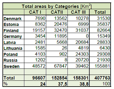
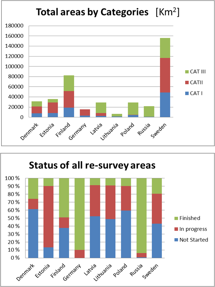
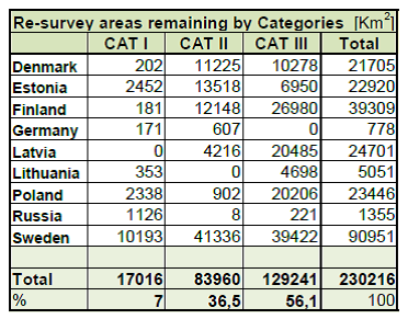
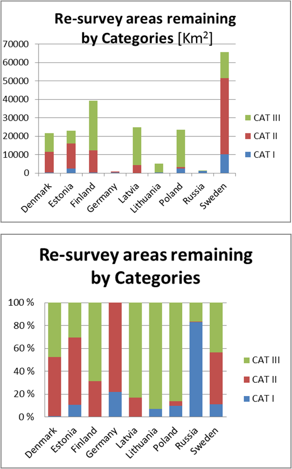
According to the re-survey database, the total amount of re-survey areas is currently (May 2014) 408,000 km2. The total amount of areas still to be resurveyed is 230,000 km2. See more details in Tables 1 to 3 and in Figure 6 to Figure 8.
The HOs have various time schedules to complete the re-surveys (see Table 3). Possible means to enhance and foster the implementation of the re-surveys should be studied. These could lead to utilizing the capacity more effectively, and to obtain extra funding to expedite the re-surveys, etc.
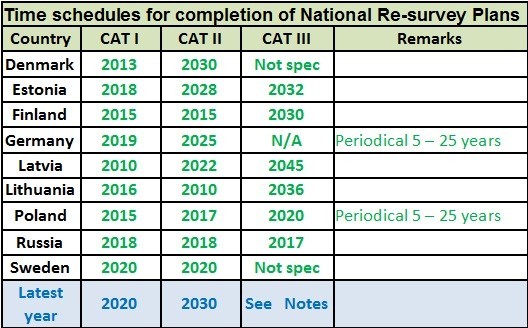
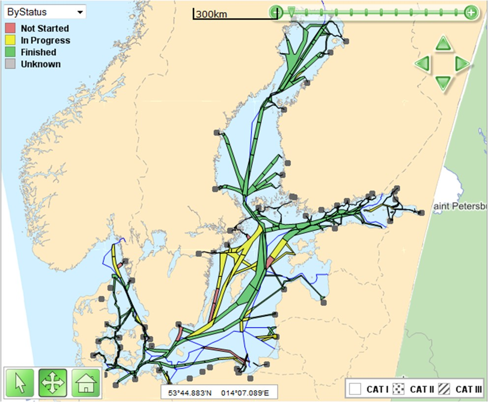
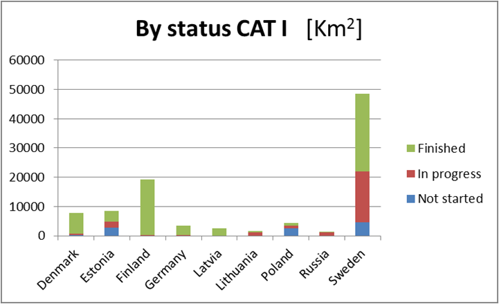
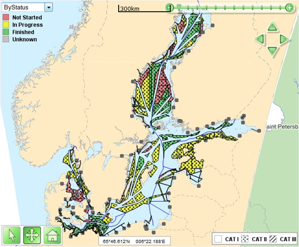
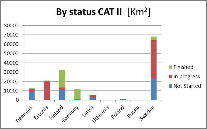
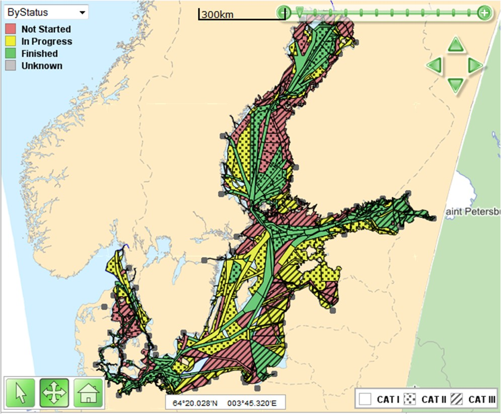
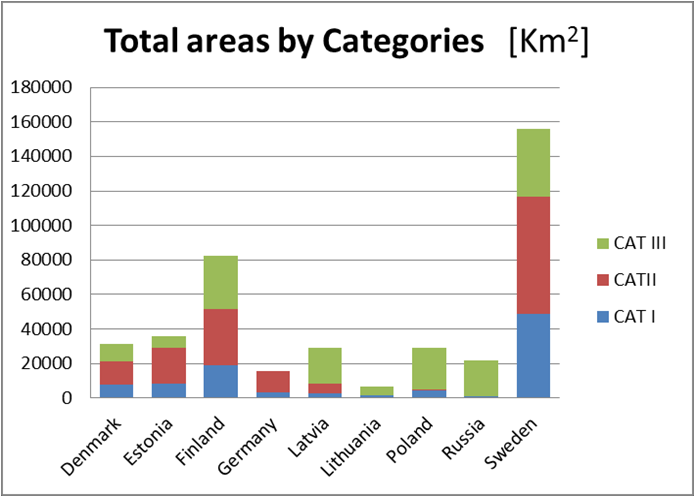
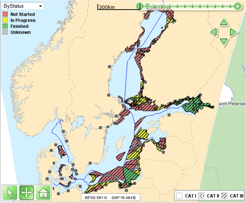
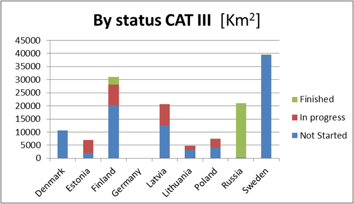
Figure 8: Summary status of CAT I, II and III and all re-survey areas (by May 2014).
6. Discussion
Benefits of Re-surveys. The re-surveys have already proved useful and beneficial. Whilst the overall goal for the re-surveys is to increase safety of navigation, other benefits are being realised:
– The re-surveys cover areas used by shipping where old or otherwise inadequate depth information currently exists, and will thus allow safer sea areas for shipping and increase the protection of the marine environment.
– Accurate and reliable full bottom coverage of surveys allow for more flexible route planning, more precise navigation and more flexibility to utilise the increased loading of ships, and thus increasing the economic efficiency of shipping.
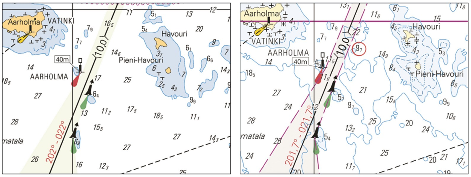
– During the re-surveys, critical new shallows or shallows shallower than previously known have been found and appropriate actions have been launched (see Figure 9)
– Well planned re-surveys enable revisions of fairways or routes, and planning of modified or new Traffic Separation Schemes.
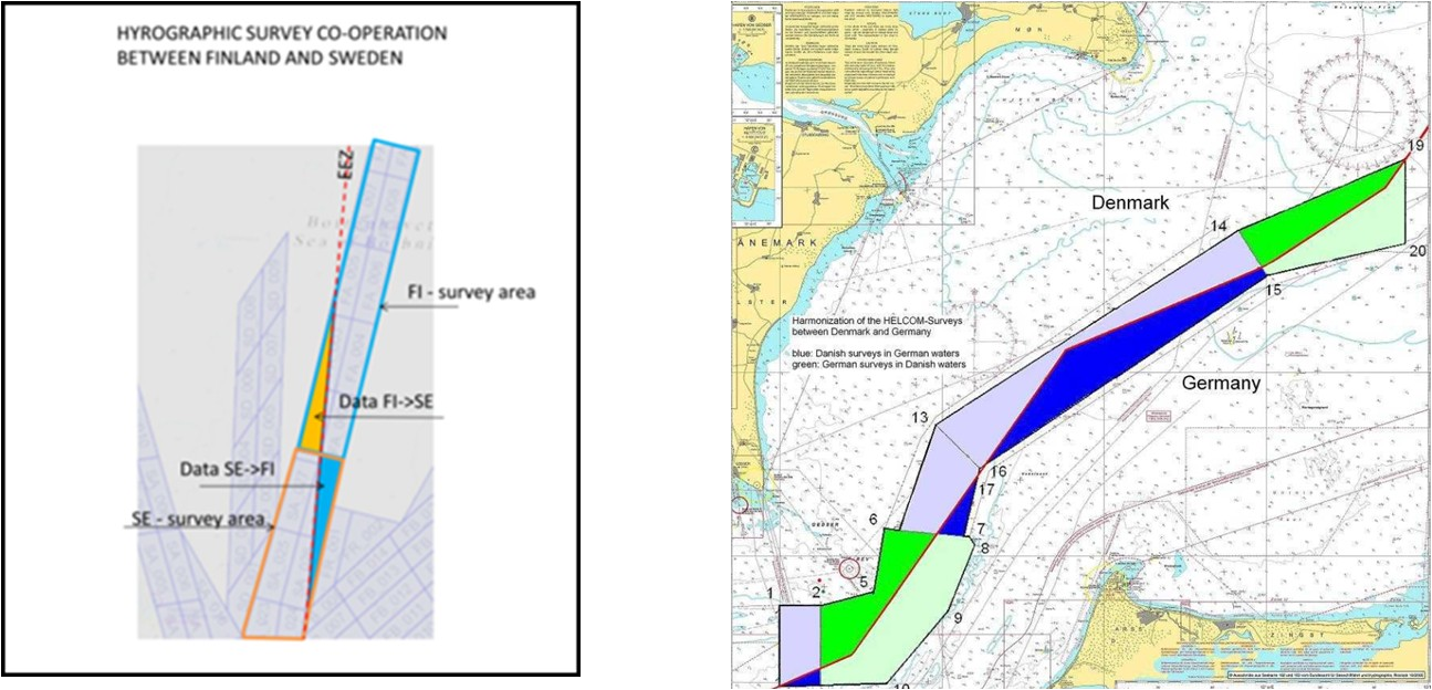
– The efficiency of the re-survey work has increased. These activities have enhanced systematic planning and co-operation between neighbouring HOs regarding surveys along border areas and allowing surveys in each other’s areas of responsibility, and thus enabled more feasible re-survey tasks and more efficient survey operations (see Figure 10)
– Modern, full coverage, accurate and reliable depth information enables, in full scale, the benefits of the next generation S-100 based ECDIS systems and enhanced navigation practices with new ECDIS functionality (e.g. 3D navigation with real time dynamic water level information, precise warnings).
– It is often more feasible and productive to completely re-survey the sea areas where old survey data exists than try to use old data and estimate where it will be useful. Old datasets are in many cases inhomogeneous and partial re-surveys are inevitable. New re-surveys will give homogenous data across national borders.
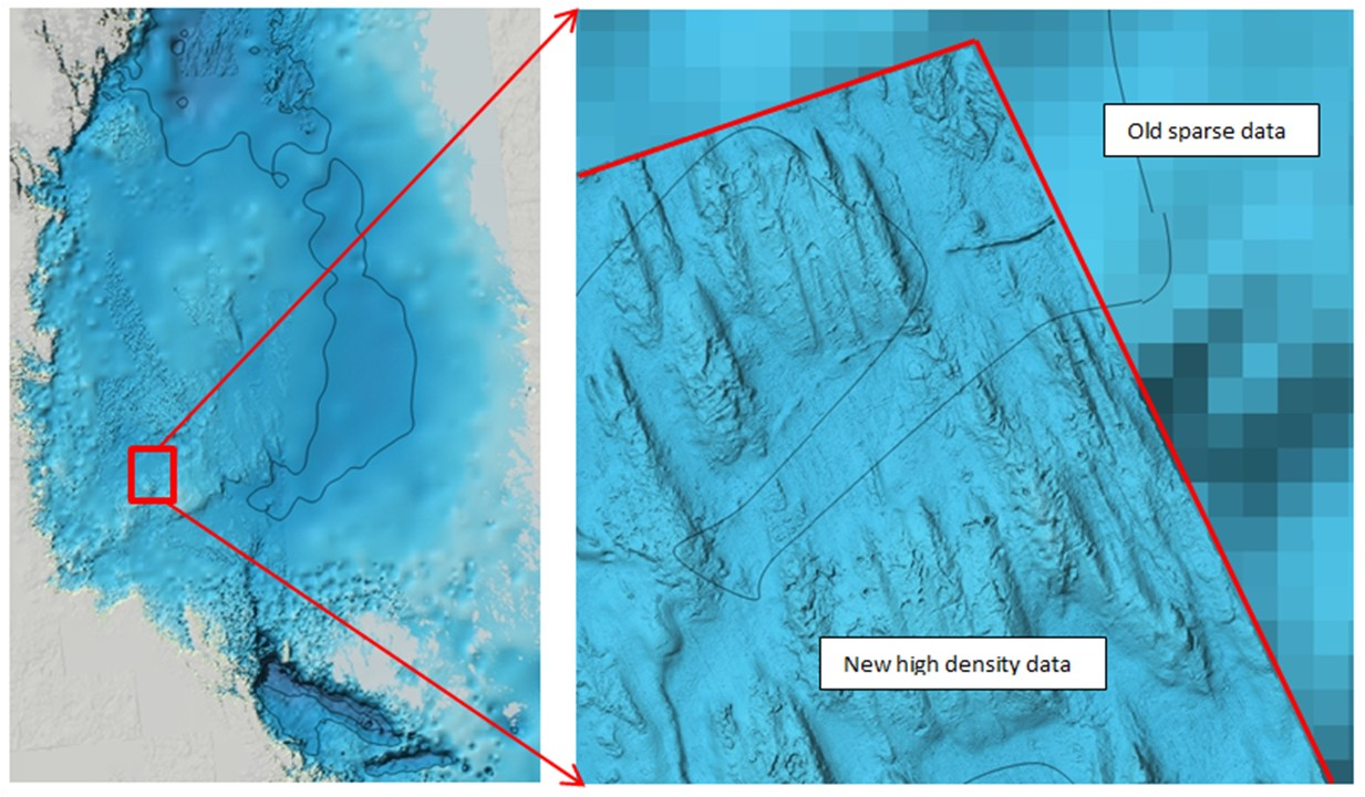
– There are growing needs for high density, accurate and reliable depth information also for other purposes than safety of navigations, e.g. for protection and monitoring of marine environment and for maritime spatial planning. New surveys will be a basis for a high density Baltic Sea Depth Model (see Figure 11.)
BSHC Co-operation has been active, friendly and fruitful. Practical and simple solutions have tried to be found whenever possible.
HELCOM Co-operation and especially the reporting to HELCOM MARITIME and EUSBSR PA SAFE Steering Committee have been fruitful. The high level political support from these bodies has been important, e.g. setting priorities and seeking funding for re-surveys both via national budgets and external sources.
Communication. The development and implementation of the Harmonised Re-survey Scheme has been communicated to BSHC, and neighbouring Regional Hydrographic Commission (NHC and NSHC) meetings, HELCOM MARITIME meetings, European Union Baltic Sea Strategy meetings, IMO NAV 51 meeting 2005, IHO Circular Letter 12/2003, IHO CHRIS/20 meeting, PIANC 2004 meeting. Also there have been presentations at the XVII IHO Conference 2007 and Hydro2010 Conference.
Future Actions. The BSHC and the Baltic Sea Hydrographic Offices have the tasks to take actions to ensure the completion of the re-surveys for areas used by navigation (CAT I and II), to promote wider use of accurate and reliable depth information, and to foster CAT III re-surveys. Below are listed some of the actions which are on-going or planned:
– Re-surveys are long-term activity and are continuing by all BHSC Countries, mainly with national resources.
– The European Union TEN-T MonaLisa project 2011-2013 has been completed and remarkable survey results have been achieved.
– A new joint application to the European Union for co-financing the completion of CAT I and II re-surveys within the European Union 2015 – 2020 financial perspective is in preparation under the name “FAMOS”. Sweden is coordinating this project.
– The BSHC has arranged a LIDAR Seminar in May 2014 for evaluating the state-of-the-art laser bathymetric survey systems and their feasibility for shallow water surveys, especially on the Baltic Sea.
– The BSHC has established its own web site (http://www.bshc.pro/) where information on BSHC activities and plans will be uploaded, e.g. links to the Re-survey Scheme and the Bathymetric Database. This web site could be linked to other web sites. Data density in the Bathymetric Database will be improved when new survey data is available.
– The MWG will continue its work according to the Work Plan 7.0 as agreed at BSHC 18th Conference in September 2013. The main tasks are to ensure the implementation of the National re-survey plans according to the estimated time schedules, to monitor the progress of the implementation, to foster actions for harmonisation of National plans, and to update and develop further the re-survey database. The MWG will report to BSHC at its annual Conferences and annually to HELCOM.
7. Conclusions
Since 2001 the goal has been to improve safety of navigation on the Baltic Sea. The Re-survey Scheme has enhanced planning and harmonisation of national re-survey plans. It has fostered completion of many re-survey areas. It has been useful for including re-survey priorities into national budgets. Clear harmonised plans have been successful at seeking external funding from the European Union.
The co-operation between all Baltic Sea countries has been open and friendly and is done on a completely voluntary basis.
Re-surveys are long term activities. By extensive re-surveys a huge amount of modern high density depth information has been collected. The main shipping routes and areas of the Baltic Sea will be re-surveyed by 2020 and all areas used for shipping will be re-surveyed by 2030.
Modern, accurate, reliable and high density depth information allows achieving the full benefits of the future generation S-100 based navigation systems.
8. References
BSHC (2001) Final Minutes of the 9th BSHC Meeting Tallinn, Estonia, 5 – 7 June, 2001.
EUSBSR (2013) Action Plan for the European Union Strategy for the Baltic Sea Region. February 2013. http://ec.europa.eu/regional_policy/cooperate/baltic/index_en.cfm
HELCOM (2001a) HELCOM Copenhagen Ministerial Declaration, 10 September 2001. www.helcom.fi
HELCOM (2001b) AMENDMENTS TO ANNEX IV “PREVENTION OF POLLUTION FROM SHIPS” TO THE HELSINKI CONVENTION. HELCOM Recommendation 22E/5, 10 September 2001. www.helcom.fi
HELCOM (2001c) Major shipping routes and harbours. HELCOM EXTRA PREP 3/2001 Document No. 2, 3 August 2001. www.helcom.fi
HELCOM (2010a) HELCOM Moscow Ministerial Declaration, 20 May 2010. www.helcom.fi
HELCOM (2010b) Vision for the Revised BSHC/ HELCOM Re-survey Scheme. Supporting document to Moscow Declaration, 20 May 2010. www.helcom.fi
HELCOM (2010c) Background information on revision of the 2001 Copenhagen Declaration regarding BSHC/HELCOM Re-survey Scheme and ECDIS training. Supporting document to Moscow Declaration, 20 May 2010. www.helcom.fi
HELCOM (2013a) HELCOM Copenhagen Ministerial Declaration, 3 October 2013. www.helcom.fi
HELCOM (2013b) Draft BSHC-HELCOM Revised Baltic Sea Harmonised Hydrographic Re-Survey Scheme, Supporting document to 2013 Copenhagen Ministerial Declaration . www.helcom.fi
IHO (2003) IHO Circular Letter 12/2003 Re-Surveying of Major Shipping Routes and Ports of the Baltic Sea Area. www.iho.int
IHO (2012) IRCC Report on Developing IHO Publication C-55, Status of Hydrographic Surveying and Nautical Charting Worldwide, Report
Conf.18/WP.3/Add.1, XVIIIth International Hydrographic Conference, Monaco, 23 – 27 April 2012. www.iho.int
9. Biography
Juha Korhonen has been working at the Finnish Hydrographic Office since 1974. He has been involved on software and database development, coordination of different development and organisational projects, and participated to IHO work on different levels. Juha has MSc on land surveying in the Technical University of Helsinki.