
Abstract
The Baltic Sea Hydrographic Commission (BSHC) recognizes the need to actively develop and maintain official nautical charts, in both paper and digital formats. This supports ships engaged on international voyages in the Baltic Sea region. Accordingly, it appoints and directs a working group to undertake this task. The working group is named the Baltic Sea International Charting Coordination Working Group (BSICCWG).
The Baltic Sea INT Charting Coordination Working Group (BSICCWG) and its main activities in maintaining the Baltic Sea INT Scheme will be described in this note. In recent years the working group’s original function to coordinate the paper chart scheme in the Baltic Sea, has been expanded to digital products, especially the ENC.
Baltic Sea International Charting Coordination Working Group (BSICCWG)
Background
The Baltic Sea Hydrographic Commission had its first meeting in Helsinki in 1983. In that meeting it was proposed that International charts covering the Baltic Sea, should be produced and that a working group to coordinate this purpose should be established. This was based on decision 26 of the International Hydrographic Conference (IHC) in 1982.
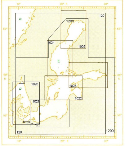
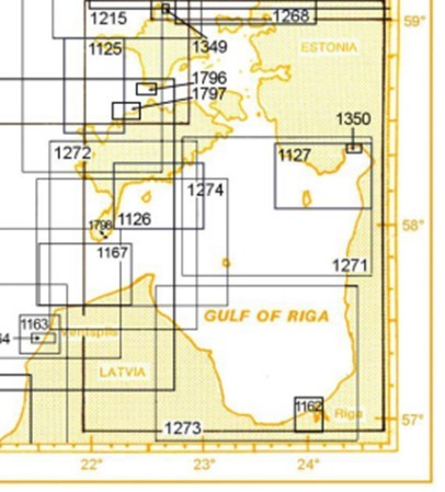
The Baltic Sea International Chart Committee (BSICC) was established to prepare an integrated INT Chart Scheme (medium scale) of the Baltic Sea (see Figures 1 and 2). The Chairman of BSICC has to report to the Baltic Sea Commission. In earlier years, it was the responsibility of all member states to report development of international charting. The first chair was from the Soviet Union (1983), followed by Denmark (1985), GDR (1988), Denmark (1999) and the current chair being Finland since 2007.
Today, all BSHC Members actively participate in the newly named Baltic Sea International Chart Coordinating Working Group (BSICCWG). The BSICCWG is a subsidiary body of the BSHC. It shall conduct its work in accordance with the IHO general Terms of Reference and the Rules of Procedure for Regional Charting Coordination Working Groups.
Tasks of the BSICCWG working group:
- To study issues related to nautical charting of the region, in particular to coordinate the allocation of production responsibilities for paper and electronic charts (INT charts and ENC), that support ships engaged on international voyages.
- To develop and maintain an integrated international chart scheme for the region.
- To reach decisions on the maintenance and updating of the documents for which it is responsible.
- To provide advice on chart schemes to individual Member States, in order to encourage adherence to IHO charting regulations, specifications and standards, and to promote and coordinate the production of international (INT) charts and ENC.
- To develop proposals for new or amended INT chart schemes to meet evolving user needs, for example, the introduction of new or amended routeing measures and the confirmed developments of international ports.
- To report yearly to the BSHC on the status of the implementation of ENC harmonisation actions agreed by the former BSEHWG. The reporting has been tasked to BSICCWG in 2010.
- To act as the custodian and maintainer of official, version-controlled catalogues, depicting the status of published and planned charts, subject to formal review and approval by Member States of the Baltic Sea Hydrographic Commission. However, the ENC catalogues may be maintained by RENCs subject to Baltic Sea Hydrographic Commission’s approval.
- To provide advice to IHB on any amendments required to maintain S-11 Part B: Catalogue of International Charts, for example, scale, limits, numbering and, as appropriate, any corresponding ENC catalogue.
- To provide advice to the Chairman of CSPCWG and IHB on any amendments required to maintain S-11 Part A ‘Guidance for the Preparation and Maintenance of International Chart Schemes’, in particular its Annexes.
- To provide advice to the chairman of the CSPCWG and IHB on any amendments required to maintain the ‘Guidelines for the Preparation and Maintenance of Small / Medium Scale ENC Schemes’, when published.
The Coordinator/Chairman will report the status and progress of the working group’s work to the Baltic Sea Hydrographic Commission. Normally the report includes e.g. an updated Regional INT Chart Catalogue (S-11, Part B), changes made to the scheme of INT Charts, status of ENC harmonization recommendations since the last meeting and status of other tasks given by BSHC.
The Coordinator collects all the updates of S-11, Part B (Baltic Sea) from member states and will forward these to IHB once a year.
The BSICCWG work shall be done in accordance with:
- IHO Resolution 1/1997 as amended [K2.19]: ‘Principles of the Worldwide Electronic Navigational Chart Database (WEND)’, to ensure a world-wide consistent level of high-quality, updated ENCs;
- S-57: ‘IHO Transfer Standard for Digital Hydrographic Data’;
- S-??: ‘Guidelines for the Preparation and Maintenance of Small / Medium Scale ENC Schemes’ (when published);
- S-11 Part A: ‘Guidance for the Preparation and Maintenance of International Chart Schemes’;
- S-4: ‘Chart Specifications of the IHO and Regulations for International (INT) Charts’, which provides the internationally-agreed product specification for both national and international (INT) charts.
Meetings
The BSICC Working Group worked for many years primarily through correspondence. The latter part of the1990s was not a very active period, due to the INT-paper chart scheme being quite stable. Since the early 2000s, large scale INT chart coverage in particular has expanded significantly from the original plan. The new tasks related to ENCs, have made the working group very active once again.
The historic, first BSICCWG meeting was held in Norrköping, Sweden, in June 2011. The main issues were:
- review of the new TORs and ROPs for BSICCWG;
- changes of production nations;
- proposed new INT numbers;
- updates to S-11;
- principals of naming charts and sea areas;
- development of an INT Chart Catalogue database;
- status of the harmonization of ENC.
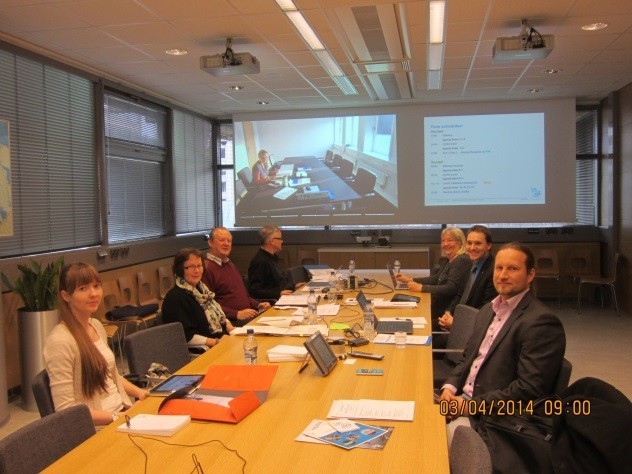
The second, very active meeting was held in Helsinki, Finland, in April 2014 (see Figure 3). Eleven energetic members took part in the meeting, with Germany participating by video link. It was an honour in having the Chairman of the North Sea ENC Harmonization WG to be an observer in the meeting. Additional issues on the meeting agenda were well illustrated by its Working Group:
- Guidance for using names on INT chart titles;
- Review of the Baltic Sea ENC harmonization recommendations;
- Report from WEND WG;
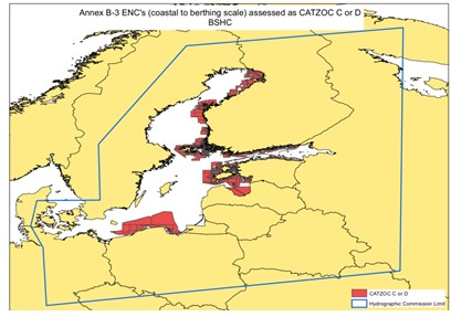
- Status of gaps and overlaps in Baltic Sea, use of CATZOC (from WENDWG) (see Figure 4);
- IHO ENC schemes;
- The possible use of 5 digit INT chart numbers;
- Additional 15m depth contours on ENCs;
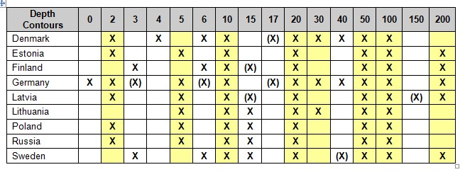
- Analysis of depth contour intervals in use (see Figure 5);
- Need to change the INT Scheme in the Baltic Sea.
Future work
The Baltic Sea INT Chart Scheme
The BSICCWG has the responsibility to maintain the INT scheme and the key issues are:
- maintaining production and printer nations;
- updating chart data;
- updating printing schedules;
- allocating new INT numbers.
During the April 2014 meeting, the BSICCWG noted that there are revisions required to the Baltic Sea INT Chart Scheme. Some local proposals have been prepared and this on-going work will be coordinated by the Chair during the next year.
Development of the Baltic Sea ENC Harmonization Recommendations
It was also noted in the same meeting, that there is a need to revise and update the Baltic Sea ENC harmonization recommendations. For example, the use of CATZOC, depth presentation, eliminating gaps and overlays will be analysed. The meeting established a drafting group to analyse the current 2008 ENC harmonization recommendations. This correspondence draft group, being led by Latvia, will report to the next BSICCWG meeting, planned to be held in April 2015.
There is a separate Note on ENC harmonization in this IHR edition.
Discussion
As first working group of the BSHC, the BSICCWG has several new tasks to be addressed and provides experienced and active members with new challenges and possibilities. Maintaining the Baltic INT Chart Scheme is still a valid task, especially when there is a need to revise the Baltic Sea INT Scheme in many areas. The development of the IHO GIS database, including INT chart Schemes, is seen as a crucial aid for that work.
Cooperation between neighbouring Chart Coordinating Groups should be increased. For example, cooperation in ENC harmonization actions between the working groups and other RHCs could be closer. The plans for developing a IHO RENC/WENC concept means the possible expansion of tasks for International Chart Coordination Groups.
Biography
Mr Jarmo Mäkinen has worked at the Finnish Hydrographic Office since 1988. He has been involved with various tasks in the hydrographic field. He has many years of competence in leading chart production and experience in working with international working groups and with private chart producers. He is the Chair for the BSICCWG. He has a University Degree in Geography from the University of Helsinki.