


Abstract
Introduction
The Baltic Sea is an almost closed basin located between Central and Northern Europe. Shipping is of vital importance for import and export for the nine countries surrounding the Baltic Sea. The surrounding countries are Denmark, Estonia, Finland, Germany, Latvia, Lithuania, Poland, Russian Federation and Sweden. At the Baltic Sea Entrance, there is a passage of 60 000 – 65 000 commercial ships every year and another 30 000 ships enter and exit the Baltic Sea through the Kiel Canal. The amount of ships has increased over the last 10 – 15 years. In combination with an almost closed sea basin, where the passage of sea water from the North Sea is limited, and very limited actions for protecting the environment during the mid-20th Century, the environmental problems in the Baltic Sea have increased to a very serious state.
The Baltic Marine Environment Protection Commission – Helsinki Commission (HELCOM) was established in Helsinki 1974 to protect the marine environment of the Baltic Sea. The contracting partners are all the countries surrounding the Baltic Sea. HELCOM’s vision for the future is a healthy Baltic Sea environment with diverse biological components functioning in balance, resulting in a good ecological status and supporting a wide range of sustainable economic and social activities, which includes safe maritime transportation. Most parts of the Baltic Sea are defined as a Particular Sensitive Sea Area (PSSA).
MonaLisa Project 2010 – 2013
Within the Baltic Sea Hydrographic Commission (BSHC), the HELCOM and EU Strategy for the Baltic Sea Region, the importance of updating hydrographic surveys to current standards is seen as a major priority in promoting safe shipping. The EU Trans European Network – Transport funding program 2010-2013 provided the opportunity to enhance this hydrographic survey work significantly. The MonaLisa project was established with public, private and academia participants from Sweden, Finland and Denmark, with the Swedish Maritime Administration (SMA) as the lead partner.
The project took the form of pilot actions and studies and encompasses the following four activities, Figure 1. This article focuses on Activity 3, but first an overview of all activities is given.
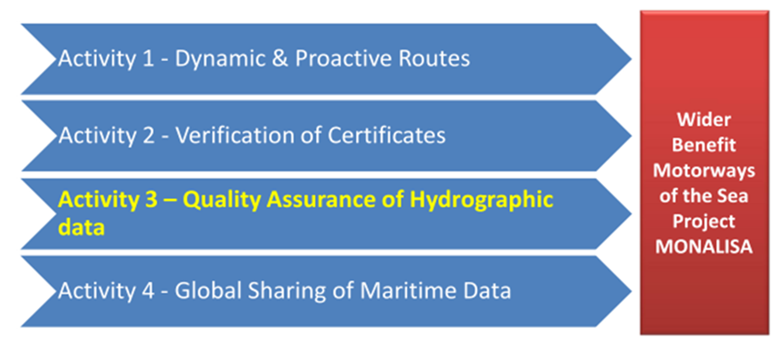
Dynamic & Proactive Route planning
[Activity 1]
This activity developed a new methodology in marine route planning, similar to air traffic management, based on the mandatory AIS system. This will improve the quality of maritime transport and safety at sea. It will provide:
- optimize and exchange routes and voyage plans -> effect on safety between ships as well as efficiency on local knowledge, pilot and berth availability;
- assistance and monitoring;
- decision support to prevent collisions, less radio communication;
- effective surveillance;
- legal impact study, looking in various convention instruments, e.g. COLREGs, SOLAS, STCW and UNCLOS;
- reduced costs and emissions;
- Big Data analysis: utilizing data from various sources in voyage planning (Figure 2) ;
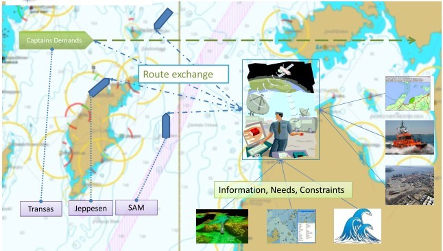
Activity 1 also covered the human interaction and legal aspects of using such a method and system. The activity has been widely presented to the maritime community all around the world and it has also resulted in the MonaLisa 2.0 project with a wide interest amongst the maritime nations, not least due to the grounding of Costa Concordia in January 2012 in the Mediterranean Sea.
A definite conclusion for Activity 1 is the EU TEN-T project MonaLisa 2.0 – to extend the test bed of MonaLisa, prepare for Sea Traffic Management and further focus on safety of navigation, safety in coastal waters and safety in ports. The MonaLisa Activity 1 identified the necessity for the introduction of Route exchange and Sea Traffic Management.
Verification System for Officers Certificates
[ Activity 2]
This activity investigated possible ways to verify, develop and test remotely, in an automated manner, different certificates held by on-board personnel that are of importance for a specific voyage. Also, studies on fatigue related questions on the officer on watch have been done.
A conclusion on Activity 2 are the safety of qualified watch-keeping personnel and occupational health to avoid fatigue and to constrain responsibilities. The study indicates a positive reception in the shipping industry, but not all flag states are supportive. A test and demonstration were performed successfully. Several studies were published addressing the various tasks, e.g. on human factors, legal and liability issues.
Ensuring the Quality of Hydrographic Data on Shipping Routes and Areas
[Activity 3]
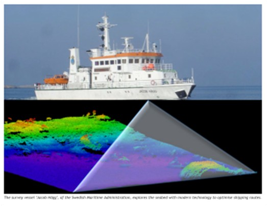
To improve safety of shipping, Activity 3 completed extensive areas of hydrographic surveys in the northern parts of the Baltic Sea by conducting re-surveys of HELCOM fairways and relevant port areas in the Baltic Sea. Re-surveys were performed with modern full coverage multi-beam method, Fig.3. Also a study was conducted towards a common vertical reference for the Baltic Sea. A Baltic Sea Bathymetric Model was built and it is freely available for uses other than safety of navigation.
Global Sharing of Maritime Information
[Activity 4]
Activity 4 tested regionally how to share maritime data on a global scale based on the experiences gained from HELCOM AIS, SafetSeaNet and Stires systems. The scenarios tested were using a high volume AIS throughput and using the proxy for open source SQL database management.
A conclusion on Activity 4 is wider public availability of common shipping data and common formats agreed in the International Association of Marine Aids to Navigation and Lighthouse Authorities (IALA), as the software and system are declared operational with the Maritime Data Exchange in Alaska and the IALA system hosted at Danish Maritime Authority. Additional test are in progress in Ireland and Canada.
This article concentrates on Activity 3, hydrographic surveys and some depth data related issues. The results of the other activities are available at http://www.sjofartsverket.se/en/MonaLisa/.
Speed up HELCOM re-surveys and ensuring the quality of hydrographic data
One of several key elements to reach a healthy Baltic Sea is safe navigation, which is not sufficient alone. It is equally vital to create knowledge about the bathymetry in the Baltic Sea through hydrographic surveys. In co-operation with the BSHC, plans for hydrographic surveys have been established within HELCOM Ministerial Declarations; see also a separate article in this issue of the IHR (Korhonen, 2014). In the HELCOM Scheme the surveys are referred to as re-surveys, since most areas are surveyed to some degree but up to 150 – 200 years ago. The sea area has been divided into three classes where category I and II (CAT I and II) are areas used by commercial shipping and category III (CAT III) are areas mostly used by leisure craft and are also important to survey for environmental purposes. The re-surveys have been conducted in areas according to the HELCOM Copenhagen 2001 and Moscow 2010 Ministerial Declarations.
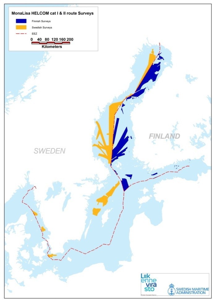
During 2011 – 2013, the re-surveyed areas have covered about 50 000 km² of HELCOM CAT I and II areas (from about 10 m depth contour and deeper) around Finland and Sweden, larger than the size of the entire land area of the Netherlands, see Figure 4. Areas vary in depth, bottom structure, water turbidity and weather vulnerability, which in turn had a direct effect on the difficulty and time spent on the field work and data post processing, as well as costs per surface area.
The areas being surveyed in this activity had previously not been surveyed with modern methods and according to international standards. In many areas, the only previously existing depth data was the result of lead line surveys being conducted over 100 years ago with very sparse depth information and several hundred metres between the spot soundings. After these modern surveys have been conducted, according to the IHO Standard for Hydrographic Surveys, S-44 ed. 5, full sea floor coverage has been obtained.
Good co-operation in the procurement process has been established and also benefitted both the Finnish Transport Agency (FTA) and the Swedish Maritime Administration (SMA):
- Common procurement documentation based on the Norwegian Hydrographic Office earlier procurement documentation (MAREANO), fine-tuned for the area and the Buyer. Each Hydrographic Office made a separate contract, due to national legislation regulations. (EU-TED 2010)
- In order to have clear requirements FTA and SMA have together agreed, with other relevant national authorities, upon a common Finnish and Swedish implementation of the IHO S-44 standard for hydrographic surveys. The implementation is called FSIS-44 (Finnish and Swedish Implementation of the S-44). To have a cross-border common implementation of the S-44 standard has proven to be a strong platform of requirements.
- Common test, start-of-work and work supervision procedures are honoured cross border.
- Exchange of work procedures and experiences in data verification to obtain quality data.
- Comparison of data on borders to enhance the ENC cell and paper chart quality and to avoid any data discontinuity steps.
- All this has contributed to the procurement transparency and data quality, which are further utilized in upcoming procurements and work processes.
In open procurement, several tenders were received. The decision was made such that in the first phase the requirements of the tenderers and the tenders had to be fulfilled. That is a typical public authority requirement, such as for social security fee and pension payment records. In the second phase price envelopes were opened and the lowest bidder received the work, after the contract had been signed. Some national security issues did apply for some of the work in territorial waters.
The quality of the work was good, after first delivery scrutiny and discussions. Sufficient time was provided for the tenderers, but some delays and delay penalties did occur due to the tenderers choice of vessels and work priorities.
About 20 Million Euros have been used for these hydrographic re-surveys during the three years 2011-2013. Of this amount about 65% has been for open public procurements, about 20% for services of general economic interest order (EU SGEI regulations) and about 15% for public administration work.
These hydrographic surveys have contributed to the safety of navigation providing full coverage bathymetric information and ensuring adequate water depth. Wider benefits include an excellent record on avoiding groundings, environmentally friendly shipping, base data for all activities and utilization for ice-breaker routing. Of course the data is used in producing new and updating existing ENCs and paper charts.
Further plans to continue and complete the HELCOM CAT I and II hydrographic surveys exist and CAT III survey plans are being drafted within the HELCOM Re-survey Scheme, as described in a separate article in this issue of the IHR (Korhonen, 2014).
Baltic Sea harmonized bathymetry model
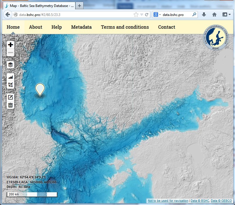
A common database of bathymetry data for the Baltic Sea Area has been established by BSHC and is hosted by the Swedish Maritime Administration. Data has been submitted from all Baltic Sea countries, except Lithuania and Russia, based on their legislation and availability of common data. For Lithuanian and Russian areas, data from the General Bathymetric Chart of the Ocean (GEBCO) is presently being used. The depth data and derived imagery is freely available under a Creative Commons Attribution license, including commercial use but not allowing use for safety of navigation purposes.
Readers are encouraged to visit: http://data.bshc.pro/ . In Fig.5 there is an example view of the user interface. The bathymetric model is also available as OGC service that is used as background charts in GIS tools and on other web- sites. The work on the Baltic Sea Bathymetry Data- base is further described in detail in a separate article in this issue of the IHR. (Hell, Öiås, 2014)
A common harmonized vertical reference for the Baltic Sea
A common harmonized vertical reference model follows the work performed in the BSHC member states Hydrographic Offices in co-operation with the national Meteorological Offices and Geodesy / Land Survey authorities.
Participation in the IHO Tidal and Water Level Working Group (TWLWG) and the EU INSPIRE Evaluation work has brought a wider viewpoint and encouragement to proceed with the work. The work requires a high level of expertise in geodesy and this has been a limited resource in both Finland and Sweden.
The common harmonized vertical reference, tied to EVRS, was decided at the BSHC17 conference in September 2012, and the national path in BSHC member states was approved in BSHC18 in September 2013. Each HO has committed to a transition into a harmonized chart datum within the Baltic Sea. The BSHC Chart Datum Working Group is fostering and monitoring this transition. There are more details on this work in a separate Note of this issue of the IHR (Mononen, 2014).
Within the MonaLisa project a study on the effects of a new harmonized vertical reference, based on the wider perspective on international work participation, has been made in the Swedish Maritime Administration and the conclusions were summarized in a report in April 2014. The report is: För-studie byte av referensnivå i SJKBAS, (Seiron, P- O., 2014) – only available in Swedish.
The conclusion from the report shows that implementation of a new vertical reference in Swedish official navigational chart products will result in some major changes. The coastline, the depth contours and the soundings (depth figures) in the navigational chart products must be changed to be in line with the new reference level This will be a heavily resource consuming task. It is however a very important task to do in order to improve safety for the shipping.
The situation, especially in the northern coast of Sweden, is today somewhat confusing for the mariners. During the ice age the pressure from the masses of ice pressed the land down and since then there is an effect of land uplift (post-glacial land uplift) in northern Scandinavia. Understanding this present situation is very complicated for the users. As an example, a depth which is presented in the chart as 10 m could actually be 9.5 m in reality. To implement the suggested new vertical reference level will be considerably simpler for the users.
In order to be able to adjust all the depth contours in the Swedish chart products, the existing depth data will be used to recalculate the depth contours according to the new chart datum. Due to the source and quality of the existing hydrographic surveys, different tolerances will be applied in different areas. In an area where S-44 is fulfilled, very tight tolerances will be used. If a depth contour, according to the new chart datum, is more than 2 meters outside the existing depth contour in the chart, this depth contour must be changed. In an area where S-44 is not fulfilled, tolerances from 20 to 21.5 meters will be accepted (depth dependant). The change to the new chart datum will lead to an important quality improvement in Swedish ENCs and paper chart products, since a new modern surveyed coast line will be implemented and a standard set of depth contours according to the modern vertical reference will be used.
Conclusions of Activity 3 and re-surveys:
Within Activity 3, the following experiences have been noted:
Procurement procedures:
Prerequisites
The overall experiences show that in order to sign a contract ensuring depth data delivery in time and with a quality in accordance with the requirements in the S-44, the organisation is dependent on experienced senior staff surveyors familiar with the latest technology. SMA and FTA have together with other concerned national authorities agreed upon a common implementation of the S-44 named FSIS-44 (http://www.transportstyrelsen.se/Global/Sjofart/Dokument/Sjotrafik_dok/Svensk-Finsk-realisering-av-S-44.pdf) in order to make it possible to make a common procurement and to make it easier for the tenderers.
To maintain the level of competence required within SMA, it is of their opinion that the organization needs to continue surveying with its own resources. In Finland Hydrographic Survey Data Management at FTA in turn has to be active in field supervision, but on the other hand is lacking resources.
The senior staff surveyors need to be involved in the process of writing the specifications of requirements. This is a very time consuming process. During the latest public procurement SMA used approximately 3500 hours within 9 months from starting writing the specifications to signing the contracts. This involves mostly senior surveyors, but also purchasing and legal experts as well.
Procurement
In some of the procurements, a “fixed sum” has been used and the tenderers have put in offers for the size of the areas they were willing to survey for that sum. It has shown that there is a real need to make good estimates of the time consumption/cost of the prepared sub-areas in order to have large enough areas for the tenderers to bid for. All risks have been handed over to the contractors; hence weather standby and other reasons for standby have to be taken into account by the tenderers.
SMA carries out procurements in accordance with applicable regulations. The primary law governing procurement processes in Sweden is the Public Procurement Act, which is based on several EC directives. Some differences exist between the Swedish and Finnish legislations and also somewhat larger differences in the actual routines used. Finland has also the General Terms for Public Service Procurement for the Government of Finland (2009) supporting the procurement process.
Hindrances during procurement
According to both Swedish and Finnish law a “Tender” is valid only if it is without reservation. In all procurements, we have been forced to disqualify some of the tenderers due to reservations similar to: “Our tender is subject to vessel availability at the time of the contract award” or “Vessels, systems and personnel are subject to availability”. These reservations appear to be standard terms for several companies but if they are not removed they will be disqualified according to the Finnish and Swedish Procurement regulations. Both Finland and Sweden have specific legislation on hydrographic surveys in territorial sea areas, which complicate the procurement process for such areas.
Market
The number of companies within the hydrographic surveying market is fairly limited. Many of them are involved in the lucrative offshore oil and gas industry. Some foreign companies have also sent in tenders, but it is assumed that mobilization costs have made it difficult for them to present winning bids. On the other hand these types of hydrographic surveys for hydrographic offices are long term work providing tasks for many years.
Quality and Delivery experiences
The foundation for getting depth data delivered in time and with a quality in accordance with S-44 is the Specification requirement. FTA and SMA have gained experience each time a public procurement has been made. However it is very complicated to foresee every possible upcoming situation when writing the specifications. Both FTA and SMA have experienced continuous problems with data quality in accordance with S-44. In order to secure depth areas shallower than 20 m (Special Order), which have been a very limited amount of areas in the MonaLisa project, SMA has placed on board one of their own senior surveyors as an observer. This is to emphasize the importance of safeguarding the higher quality required within Special Order and make sure that the accurate procedures in the contract are followed.
It has become a rule of thumb that service providers are given a vertical tolerance that is about half of the given order in S-44 ed. 5 / FSIS-44 (see Figure 6). This will leave some room for vertical offset errors that cannot be visualized and verified in relative data sets. All visual systematic errors shall be flagged, of course. (Hughes Clarke 2000)
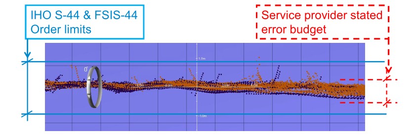
When it comes to the error budgets requested in the tender, it seems that many survey companies use only the input values from the system manufacturer’s data sheets. As an example, it seems normal to use an error value of 0.1 m/s for the sound velocity, as stated by the manufacturer, whilst the real errors, taking into account also spatial and temporal variations, rather might be around 2‑3 m/s as the taken profiles only are valid at the specific point and time it was taken.
In all procurements FTA and SMA have requested that each vessel has to prove that the complete survey system fulfils the requirements by surveying over a fixed geodetically surveyed manmade bottom object prior to commencing the survey. The Buyers have also demanded that a small test area (eight short run lines) in the survey area should be used as a horizontal and vertical reference to be surveyed in the beginning and as a final check so to see that nothing has changed in the system setup during the surveys.
If the surveying company has had a break in the surveying, then the test area has been surveyed prior to the ship leaving and at return to the area. Survey over a manmade bottom object has in some cases resulted in revealing static depth errors of up to 46 cm. The companies have been unaware of this and also unknown in their previous surveys.
SMA and FTA have also realized the importance of keeping a strict policy regarding the approval of a vessel survey system and its importance to calibration before the start of a survey. Approval procedures must be clearly explained and written in the specifications as well as the circumstances and cases when the system or calibration are not accepted and must be rectified. The contractors are of course eager to start the field survey as soon as they have arrived in the survey area and, in order not to cause any costly delays in approval procedures, one must have qualified personnel on standby 24/7 for reviewing the reports and as on-board overseer. In some occasions unnecessary and time consuming disagreement occurred be- tween the contractor and the buyer whether the survey system or calibrations met the qualifications according to the specifications.
All surveying has been carried out using traditional tidal corrections and, for that reason, both FTA and SMA have requested that tables of dynamic draft/squat should be used. This does not seem to be a standard procedure for the surveying companies because on all the vessels used, the depth dependent squat has been significantly higher than the companies had expected. FTA and SMAs opinion is that the vessel’s dynamic draft and squat needs to be taken into account both when using traditional tide correction and in order to make it possible for a direct comparison of traditional tides to tides derived using GNSS technology.
It is also fundamental to have experienced in house staff that can take care of and evaluate the delivered depth data in order to ensure that it meets the specified requirements. Many data sets have been rejected after the first delivery, and there have been several discussions regarding differing interpretations of the specifications. SMA has also encountered gaps in delivered depth data which in some cases has arrived several months after the vessel left the area and therefore, in these cases, it was very complicated to arrange infill in these areas.
FTA and SMA have also experienced several problems with the companies’ abilities to deliver data according to an agreed delivery schedule. There are examples where the contracted company, probably in order to reduce costs, has minimized their post processing staff which has led to much delays in data deliveries. In some cases maximum penalties for delays have been assigned to the service providers.
General Cost Levels
Comparison of cost between different vessels and different depth areas is extremely complicated. The Finnish and Swedish coastal areas are filled with islands and varying bottom topography. Using contracted companies has set focus on cost efficiency. In order to achieve the same survey costs (or lower) compared to contracted companies, SMA has utilized its own vessels in a more cost efficient way. Surveying 24/7 is now standard on vessels which are of sufficient size and are surveying in suitable areas. The Finnish Maritime Administration outsourced all its internal fleet when the Finnish Transport Agency was established (amalgamated).
Today, SMA has lower costs using their own vessels than when purchasing surveying services. The contracting survey costs are generally higher due to the companies’ necessary profit margin and the added costs for specification writing, procurement costs, quality assurance and approval procedures with experts and specialists as senior surveyors and post processing personnel.
Conclusions from the MonaLisa project
The possibility to get co-financing from the TEN-T program for this MonaLisa project has made it possible to survey much larger areas in Sweden and Finland, which had not been possible earlier with just ordinary resources. In the case of Sweden, 30 000 km were surveyed during 2011 – 2013. If only ordinary resources had been used, less than 50% of that amount would have been surveyed. In 2013, an area of 15 000 km was surveyed in Swedish waters. Such a large area of new surveys in one year has never been achieved before. When co-financing was made possible it was extremely important to be able to use contracted companies in order to extend the capacity of surveying.
In Finland some extra 10000 km2 was put out for open tendering and completed with the support of the MonaLisa grant.
The co-operation between FTA and SMA has been very fruitful during the project. Being able to pro- cure such extensive areas in both Sweden and Finland has probably led to lower surveying prices than would have been the case if just one part had procured smaller areas. FTA and SMA have learned a lot from each other at different levels within the two organisations. This includes project management, procurement procedures, quality assurance and data processing. The Swedish and Finnish Hydrographic Offices have a long tradition of co-operation and the MonaLisa project has certainly strengthened this close co-operation. A specific important result is that Sweden and Finland now have a common implementation of the IHO standard for surveying S-44; FSIS-44 (Finnish and Swedish implementation of S-44). This is now used by all authorities involved in surveying. When a harbour authority procures a surveying project in its harbour, the requirements in FSIS-44 should be fulfilled.
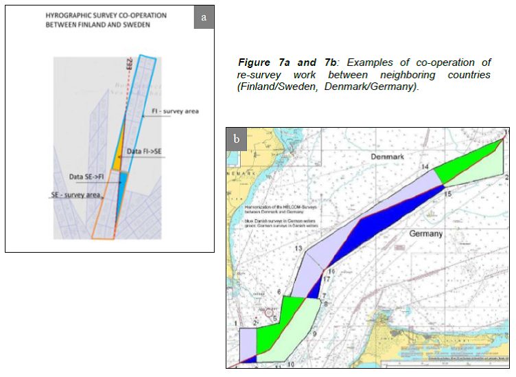
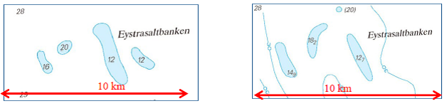
The efficiency of the re-survey work has increased. These activities have enhanced systematic planning and co-operation between neighbouring HOs regarding surveys along border areas and allowing surveys in each other’s areas of responsibility, and thus enabled more feasible re-survey tasks and more efficient survey operations. See two examples in Figure 7.
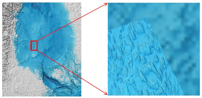
The re-surveys have already proved useful. The overall goal for the re-surveys is to increase safety of navigation and the protection of the marine environment. For instance, the re-surveys covered areas used by shipping where old or otherwise inadequate depth information currently exists. During the re-surveys, critical new shallows or shallows shallower than previously known have been found. Reliable full bottom coverage of surveys allow for more flexible route planning and enable revisions of fairways or routes and planning of modified or new Traffic Separation Schemes. New data will be available as extensive as possible e.g. via the Baltic Sea Bathymetry model, see an example view in Figure 8.
In addition to the above listed conclusions the Activity 3 re-surveys have fostered similar benefits as described in the Articles of the Baltic Sea Re-survey Scheme (Korhonen, 2014) and the Baltic Sea Bathymetry model (Hell, Öiås, 2014) in this IHR issue.
Future plans
At the HELCOM ministerial meeting in Copenhagen in June 2013, an updated time table for hydrographic surveys in the Baltic Sea was agreed upon. The plan encompasses all areas in the Baltic Sea used by commercial shipping and is very ambitious and challenging for all HOs involved. In order to be able to fulfil this ambitious plan, co-financing is essential. The success with the MonaLisa project surveying extensive areas has led to the conclusion that Sweden, along with the BSHC invited partners involved, plan for a new application to the EU.
The FAMOS project has been established in the beginning of 2014, planning for an application to the EU INEA CEF Transport to finalize the HELCOM CAT I & II hydrographic surveys within participating nations. Some plans for further surveys of HELCOM CAT III areas also exist, but not yet as far in planning as FAMOS.
Acknowledgements
References
EU-TED Invitation to tender BSS2011, EU – TED 2010 S/195 298217.
Hell, B., Öiås, H., 2014, A new bathymetry model for the Baltic Sea, International Hydrographic Review, October 2014.
Hughes Clarke, John E., 2000, Acoustic Seabed Surveying – Meeting the new demands for Accuracy, Coverage and Spatial Resolution, Geo-matica, v.54, no. 4, p.463-471.
Korhonen, J., 2014, Baltic Sea Hydrographic Re-Survey Scheme, International Hydrographic Review, October 2014.
Mononen, J., 2014, Harmonisation of Vertical References on the Baltic Sea, International Hydrographic Review, October 2014.
Seiron, Per Olof, 2014, Förstudie byte av referensnivå I SJKBAS, 10 April 2014 (only available in Swedish.)
Biographies
Seppo H Mäkinen has a M.Sc in Surveying Engineering at Aalto University (formerly the Helsinki University of Technology) in 1989. He has worked in various duties within the Finnish Hydrographic Office since 1990. Seppo has also attended the University of New Brunswick achieving the theory part of the FIG/IHO Cat A hydrographic certificate. Currently he is responsible for hydrographic survey data procurement and is also acting as head of the Hydrographic Survey Data Management unit. Mr. Seppo H Mäkinen has chaired for MonaLisa activity 1.
Ulf Olsson has a Master’s degree in Hydrographic Science, at the University of Southern Mississippi, 2003, and has a FIG/IHO Cat A certification. He also has a Master Mariner and Nautical Science education at Malmoe Merchant Marine Academy 1982. He has served as Hydrographic Quality Manager and Senior Surveyor 2003-2011 and from 2011 he has been Head of Hydrographic Field Survey at the Hydrographic office at the Swedish Maritime Administration.
Magnus Wallhagen is Production Manager at the Hydrographic Office at the Swedish Maritime Administration having production responsibility from surveying to nautical products. Working at SMA since 1991, he has a technical background as Manager of the Chart Database and has also been Project Manager during the 1990s when the Swedish paper charts were digitized. Magnus has also been involved in several development projects within SMA and with neighbouring countries’ HOs, as well as being involved in some of the IHOs technical working groups and regional commissions. Education at Higher Course includes Cartography, GIS, English and one year civil service on-board a surveying ship.
Hans Öiås has a High School degree in Electric Engineering at the Ebersteinska Higher Technological School in Norrköping. He has also studied a Higher Course in Computer science specializing in Logistics and Production Management as well as some courses in structured programming and GIS at the Linköping University. He has worked for the SMA since 1986 as a survey systems engineer and hydrographic surveyor. He has experiences in system development, system integration as well as procurements of both survey systems and hydrographic surveys. He was appointed as Project Manager for the development of the Baltic Sea Bathymetric Database within the MonaLisa Project