

Abstract
As of 2008, the Baltic Sea Hydrographic Commission (BSHC) had already developed a set of recommendations to harmonise its members ENCs covering the Baltic Sea. Most of these recommendations have now been completed and the implementation process is described below. Several future harmonisation issues are identified and future development plans described, including a FIN-SWE Pilot for harmonising depth presentation.
Baltic Sea ENC Harmonisation Recommendations 2008
Background
In 2007, the BSHC formally recognized the need for harmonisation of the ENCs covering the Baltic Sea. It established an ENC Harmonisation Working Group (BSEHWG) to review the inconsistencies between Baltic Sea ENCs and to propose actions to resolve them. The work resulted in 17 recommendations for improving the member states’ ENC consistency, and most were aimed at the ENC producers. In August 2008, the BSHC approved the working group’s report and recommendations. It also agreed on an implementation schedule for the majority of the recommendations and monitored their implementation over the following years.
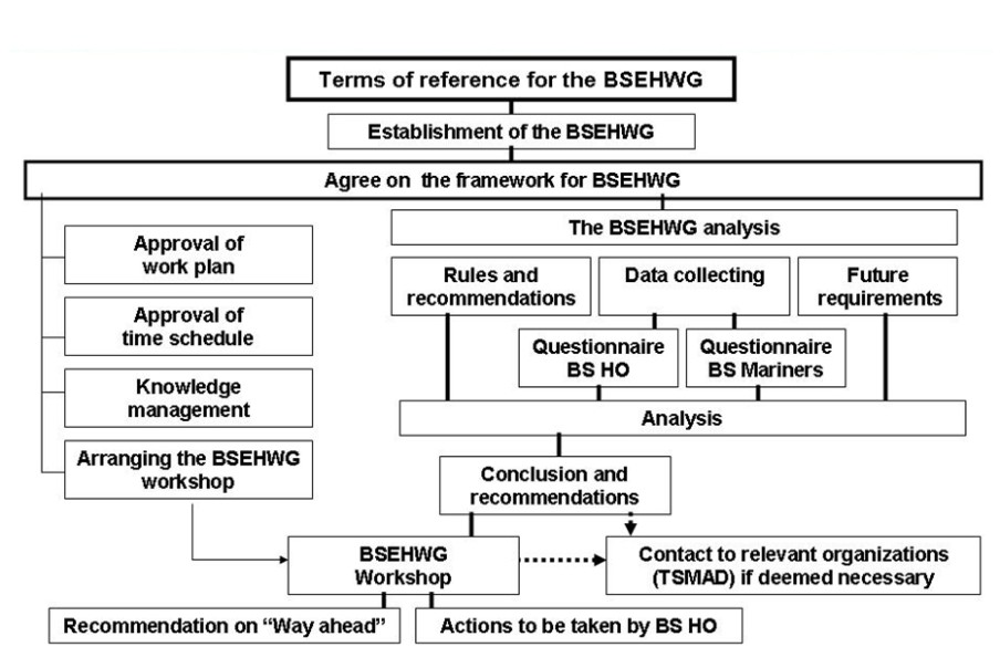
The BSEHWG work plan and time schedule were approved at the 12th BSHC Conference in Klaipeda in 2007, as illustrated in Figure 1.
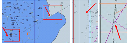
ENC coverage of the Baltic Sea was already fairly good in 2008, so it was an appropriate time for the HOs to concentrate on improving the quality and consistency of their ENCs. Therefore, the BSEHWG was able to commence its work with a study of the existing ENCs and identified a large number of inconsistencies between them. Most of the inconsistencies can be seen visually on the ECDIS screen at the border areas between countries. Some example cases are shown in Figure 2.
The Working Group designed and distributed two questionnaires: one for the Baltic Sea Hydrographic Offices and the second for mariners using Baltic Sea ENCs in their ECDIS.
Most of the inconsistencies identified can be found in the General, Coastal and Approach usage bands. There is only one Overview cell in the Baltic Sea. Harbour and Berthing cells are mainly disjointed, so no inconsistencies can be seen between them.
The Working Group evaluated the inconsistencies they and the questionnaire respondents had identified, with a focus on the following issues:
- Use of Compilation scale and Usage bands;
- Use of Scale minimum (SCAMIN);
- Use of Depth contours (DEPCNT) and Depth areas (DEPARE);
- “Across Borders” to cover all features in the border areas;
- Testing for harmonisation before launching ENC;
- Use of up to a 5-meter buffer zone to eliminate gaps.
Addressing these harmonisation issues was prioritised from a mariner’s point of view.
Clear needs for harmonisation
For mariners, most of these inconsistencies are not strictly critical in safety terms. Inconsistent ENC displays on ECDIS may require that mariners use additional attention to understand the discrepancies and thus experience extra work. Inconsistencies may also decrease mariners’ trust in the ENCs and the use of ECDIS.
There are also many international regulations and recommendations that require harmonisation. These include the following:
- SOLAS V Regulation 9 requests Member states to “co-operate”, “coordinate activities” and provide “greatest possible uniformity”.
- Mandatory ECDIS carriage requirements, which are now in the process of IMO approval, also imply that there is adequate ENC coverage and that their quality and consistency are at an acceptable level.
- The IHO WEND Principles and Guidelines also request uniform and consistent ENCs and regard ENC consistency issues as important as ENC coverage.
Implementation of Baltic Sea ENC Harmonisation Recommendations 2008
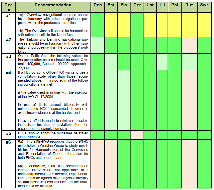
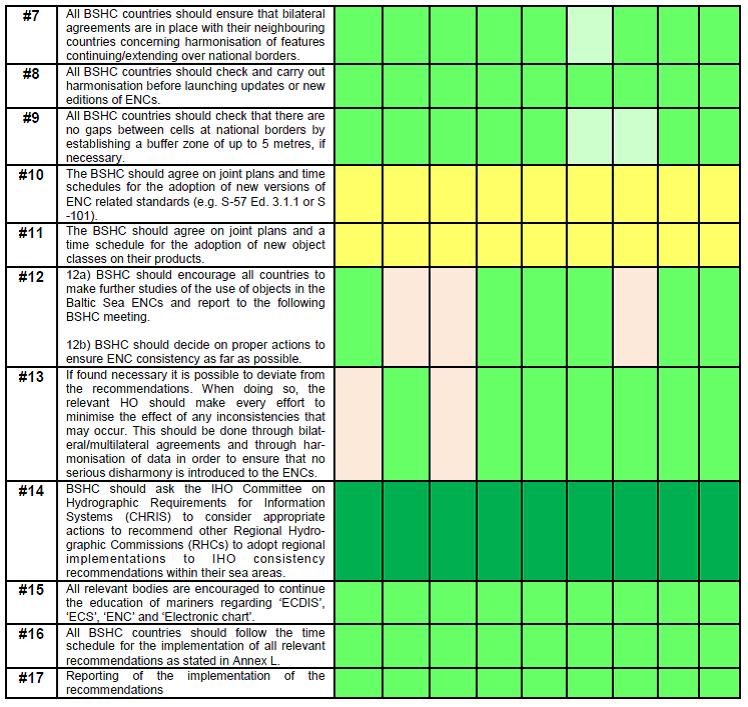
Based on the questionnaires and subsequent analysis, the BSEHWG crafted a set of 17 recommendations that are aimed at helping ENC producers to avoid the most obvious inconsistencies. These included the following:
- All BSHC countries should ensure that all navigational purposes are in harmony with other navigational purposes within the producers’ portfolios.
- All BSHC countries should use jointly agreed compilation scales and SCAMIN values for all Baltic Sea ENCs.
- All BSHC countries should harmonise, with their neighbouring countries, features continuing or extending over national borders.
- All BSHC countries should check that there are no gaps between cells at national borders by establishing a buffer zone of up to 5 metres, if necessary.
- All BSHC should check and carry out harmonisation before launching updates or new ENCs or new editions.
- The BSHC agreed that new versions of ENC related standards (e.g. S-101) or new object classes should be adopted according to jointly agreed plans and time schedules.
These recommendations are in line with IHO recommendations, with some deviations on the use of SCAMIN. It was found that it was not possible for all HOs to implement exactly the IHO recommendations, but that a more feasible compromise solution could be implemented by all Baltic Sea HOs.
Further, all BSHC countries were encouraged to make further studies of the use of objects in the Baltic Sea ENCs and report their findings at the following BSHC meetings. Additionally, all BSHC countries were asked to make proposals for further actions to ensure ENC consistency.
The working group also discovered that, even among professional mariners, there still are many misunderstandings regarding the terms ‘ECDIS’, ‘ECS’, ‘ENC’ and ‘Electronic chart’. Thus all relevant bodies were encouraged to promote the education of mariners regarding these issues.
At the BSHC 13th Conference, the commission’s members agreed that these recommendations should be implemented and that they would monitor the implementation at their annual Conferences.
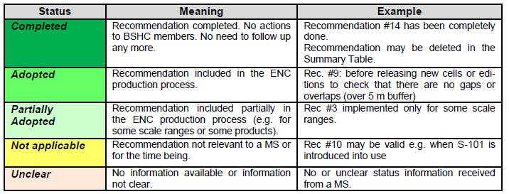
Most of the recommendations can now be regarded as completed or under implementation by all BSHC Members. The current status of implementation is shown in Tables 1 and 2 at Annex A.
IHO Recommendations
Based on this work, and on similar work done by Canada, the IHO WEND, now WENDWG and CHRIS, now HSSC Committees regard the improving of ENC consistency and thus fostering wider use of ECDIS and ENCs as important for increasing safety of navigation. They encouraged other RHCs to consider similar cooperation and harmonisation actions for adopting regional implementations of IHO recommendations. Also the IHO ENC Production Guidelines will be amended to allow and promote this kind of regional approach. [IHO, 2008]
At their 2008 meetings, the IHO WEND and CHRIS committees recognized regional implementation of the IHO recommendations to be feasible and to increase the safety of navigation and recommended to promote this kind of cooperation to all Regional Hydrographic Commissions.
WENDWG Analysis and Further Guidance
The IRCC WEND Working Group (WENDWG) monitors world-wide ENC coverage, gaps and overlaps, and some harmonisation issues (e.g. use of CATZOC). WENDWG reports the identified ENC gaps and overlaps. In agreement with the IRCC, WENDWG has developed procedures for actions to eliminate gaps and overlaps within 6 months’ time.
FIN-SWE Pilot for harmonising depth presentation
Already in 2008, it was evident that further studies would be required to solve some inconsistency issues, e.g. on conveying and the presentation of depth information. These are highly related to the specifications of production systems and databases, and demand major work to be undertaken. The BSHC established a Working Group to evaluate the depth harmonisation issue further, but the group made no remarkable progress. In 2012, the BSHC established a pilot project between Finland and Sweden for improving the harmonisation of depth information and presentation of both ENCs and paper charts.
The project has identified many inconsistencies, including mismatch of Navigational Purposes, density of soundings, SCAMIN settings on soundings and on depth contours, representation of depressions, mismatch of depth contours, generalization of depth contours, non-equivalent depth contours and rounding of soundings.
These different types of inconsistencies call for different actions that have now been grouped into three blocks. The first block being an update of the chart data, the second block being already planned actions and the third block being the development of new guidelines. See Figure 3.
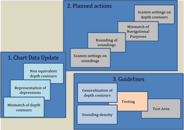
The deliverables of the third block “Guidelines” are finalized guidelines regarding sounding density and generalization of depth contours. A plan for the implementation of the guidelines in the chart products will also be a deliverable for the third block.
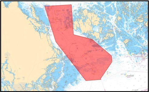
A joint chart updating process is being developed within the pilot project. Testing of the procedures will be formalized and the testing is planned to start in August 2014. The Åland Sea has been chosen as the test area partly because of the Traffic Separation Scheme and partly because Finland and Sweden both have Coastal ENCs of the area. The guidelines will be tested for navigational purposes General, Coastal and Approach on a test area between Finland and Sweden. See Figure 4.
Plans to further develop the Baltic Sea ENC Harmonisation Recommendations
Baltic Sea ENC harmonisation issues are coordinated by the Baltic Sea INT Chart Coordinating Working Group (BSICCWG). The BSICCWG noted in its meeting in April 2014 that recommendations need to be further developed and revised – at a minimum for the use of CATZOC, MAGVAR, SCAMIN, depth presentation and eliminating gaps and overlaps. In April 2014, the BSICCWG established a Correspondence Group to study these recommendations in more detail. The Correspondence Group should report to BSICCWG by April 2015.
Discussion
The aim to have more harmonized ENC data in the Baltic Sea via recommendations to member HOs has been found useful for encouraging HOs to find inconsistencies upon which they must report every year. This has improved ENC consistency in the Baltic Sea area. ENC consistency is better today than in 2008, but still there are issues to be harmonized. Status reports are seen as an important annual means of updating progress on the situation. More closer communication, co-operation and sharing of experiences of other RHCs will be welcome.
References
IHO (2004)Improving ENC Consistency, IHO Circular Letter 47/2004, www.iho.int
IHO (2008)IHO Circular Letter 89/2008, www.iho.int
Annex A: Status of Implementation of 2008 Recommendations
Biographies
Jens Peter Hartmann is Senior Advisor at the Danish Geodata Agency which also contains the Danish Hydrographic Office. He is the agency’s primary contact and coordinator for marine activities and is involved in the implementation of a Danish Marine Spatial Data Infrastructure and Marin Spatial Planning. He is Chairman of the IHO Marine Spatial Data Infrastructure Working Group (MSDIWG) and Chairman of the Baltic Sea Marine Spatial Data Infrastructure Working Group (BSMSDIWG) under the Baltic Sea Hydrographic Commission (BSHC). Jens Peter has been Head of the Danish Hydrographic Office and had served as Head of the Maritime Inspectorate at the Danish Maritime Administration. He has also served as chairman for a working group under the BSHC that addresses the harmonisation of ENCs in the Baltic region and as an external lecturer at Copenhagen Business School. Jens Peter is educated as a naval officer in the Royal Danish Navy and has worked as a master mariner in the commercial fleet and as a commercial pilot. Jens Peter holds degrees in organisation and strategy from the Copenhagen Business School.
Jarmo Mäkinen has worked at the Finnish Hydrographic Office since 1988. He has been involved with various tasks in the hydrographic field. He has many years competence of leading chart production and experience in working with international working groups and with private chart producers. He is the Chair for the BSICCWG. He has University Degree on Geography from the University of Helsinki.