
Abstract
Because there is no common vertical reference system for hydrographic or navigational tasks in the Baltic Sea, the Baltic Sea Hydrographic Commission (BSHC) considers this issue to be important to harmonise chart datums in the Baltic Sea. The BSHC Chart Datum Working Group (CDWG) has studied the needs and possibilities to move to a harmonised vertical reference system and evaluated alternatives for it. The European Vertical Reference System (EVRS), has been approved by the BSHC as a harmonised vertical reference system for the Baltic Sea. At the same time, the CDWG has proposed to the International Hydrographic Organization’s (IHO) Tidal and Water Level Working Group (TWLWG) to revise the IHO resolution on vertical datums to better reflect the non-tidal and inland waters (IHO Resolution 3/1919 as amended).
The CDWG has developed a roadmap for the transition to the EVRS based harmonised reference system and this has been approved by the BSHC. The goal is to establish the harmonised vertical reference system in use in the year 2020. To make the transition successful, all relevant stakeholders within the Baltic Sea region have to become informed and committed to support the work. To assist this process, the CDWG is also establishing closer co-operation with the Baltic Sea Oceanographic Observation System (BOOS).
Chart Datum Working Group (CDWG)
In 2005, the BSHC establish the CDWG to study and foster the harmonization of vertical reference systems. CDWG members include representatives from all Baltic Sea Hydrographic Offices, permanent representatives and observers from national geodetic and oceanographic organizations and BOOS.
The CDWG reports to BSHC which also approves the Terms of References and Work Plan of the CDWG. The CDWG has annual meetings for decision making, follow up and to review the current situation concerning harmonisation of vertical references. The CDWG can also prepare questionnaires to the members to study and clarify relevant issues.
Selection of the harmonised vertical reference system
As there is no common vertical reference system for hydrographic or navigational tasks in the Baltic Sea, BSHC has identified the importance to harmonize chart datums in the Baltic Sea. In harmonising the vertical reference system, there will be one common chart datum for the whole area. This provides numerous advantages for mariners, national hydrographic offices and other organisations using bathymetric data. It also allows the future capabilities of the new S-100 based products and water level data.
Today, countries have their own national systems differing from each other. Systems are based principally on mean sea level (MSL), but national realizations of MSL are different. This situation is inconvenient for navigators, for data transfer between Hydrographic Offices and for other users of depth and water level data. There are also some other reasons why MSL is no longer a feasible chart datum. One reason is the postglacial rebound which changes the depths around 7-9 mm in a year in the Bay of Bothnia. Another reason is that the prediction of MSL has become difficult because of different climatic phenomena.
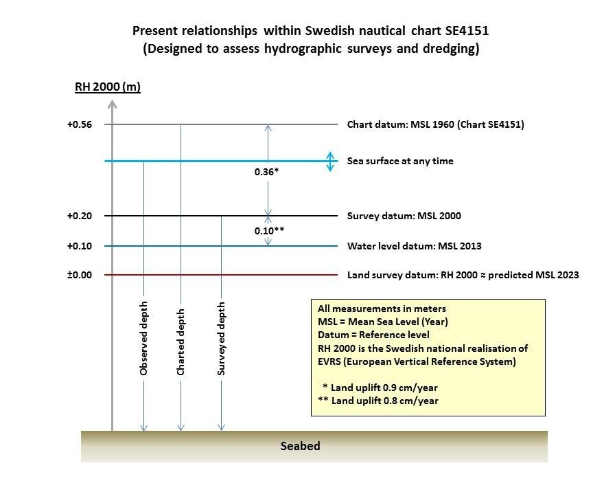
Figure 1a illustrates the present complex situation with different MSL-based chart datums. In MSL-based vertical reference systems, it has to be taken into account several different vertical reference levels related to MSL of different years. The surveyor and chart-maker need to be aware of the year of MSL used as the chart datum for a chart. Also they have to be aware of the survey datum where 0-level might be different than the MSL of the chart. Also the datum, in which the apparent height of the sea surface is provided, can be different than survey datum. In particular, the navigator, has also to be aware of the differences of chart datum and the datum, in which the apparent height of the sea surface is provided. This also applies to fairway planning and construction.
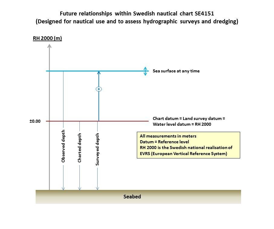
Figure 1b illustrates the clear situation after the EVRS based harmonized vertical reference system has been adopted. For all the navigational and hydrographic purposes there will be one reference level and also the apparent height of the sea surface will be referenced to it. Thus users have to be aware of only one reference level and water level changes can be simply and safely reduced to the correct chart datum.
The CDWG studied the feasibility of the European Vertical Reference System (EVRS) as a principal alternative for a harmonised vertical reference system for Baltic Sea nautical charts. At the same time, the CDWG also studied possible time schedules and the necessary preconditions for each Baltic Sea country to adopt the harmonized datum on their nautical charts. Based on these studies, the CDWG proposed the EVRS as a harmonised vertical reference system to be approved by BSHC.
BSHC accepted the EVRS as a harmonized vertical reference system for the Baltic Sea and there is good commitment among the Baltic Sea countries to adopt this harmonized datum.
There are numerous benefits which can be achieved with a well-defined, international EVRS-based harmonized vertical reference system. All the depth and water level information can be provided in the same datum for the whole Baltic Sea. At the same time, confusion between different chart datums can be eliminated. Data transfer between national Hydrographic Offices and other organisations will become easier and safer. The EVRS is also a common European vertical reference system to which many national height systems are based. Hence, depths on sea and heights on land can be referenced to the same vertical reference system.
Transition to the harmonised vertical reference system
Implementation is a long process and is estimated to be completed by the year 2020. There are several issues to be solved before all nautical information will be referred to the harmonised vertical reference system. The change to the EVRS-based reference system has practically no effect in the southern parts of the Baltic Sea, but in the northern parts it can have around 15 – 20 cm effect on depths. Thus it is important to analyse nationally the present situation to be able to make decisions such as the scope of the transition, technical and legislation issues, data transformation methods, water level information and publication of products. Also, it is important to inform users of navigational data about the change and how it affects them practically.
There are many national and international issues to take into account. To make the process successful and efficient, one of the key issues is to get all relevant national and international bodies to communicate and cooperate together. The CDWG supports the communication and cooperation e.g. by being a forum for all BSHC member countries and other relevant bodies.
One of the most important issues to remember is that the mariner needs the charted depths and broadcasted water level information in the same reference system. To provide all the information safely and reliably to the users during the transition period, it is essential to have good cooperation and communication between different organisations such as the national Hydrographic Offices, geodetic and oceanographic organizations (e.g. BOOS), mariners and other users of depths and water level data both in a national and international context.
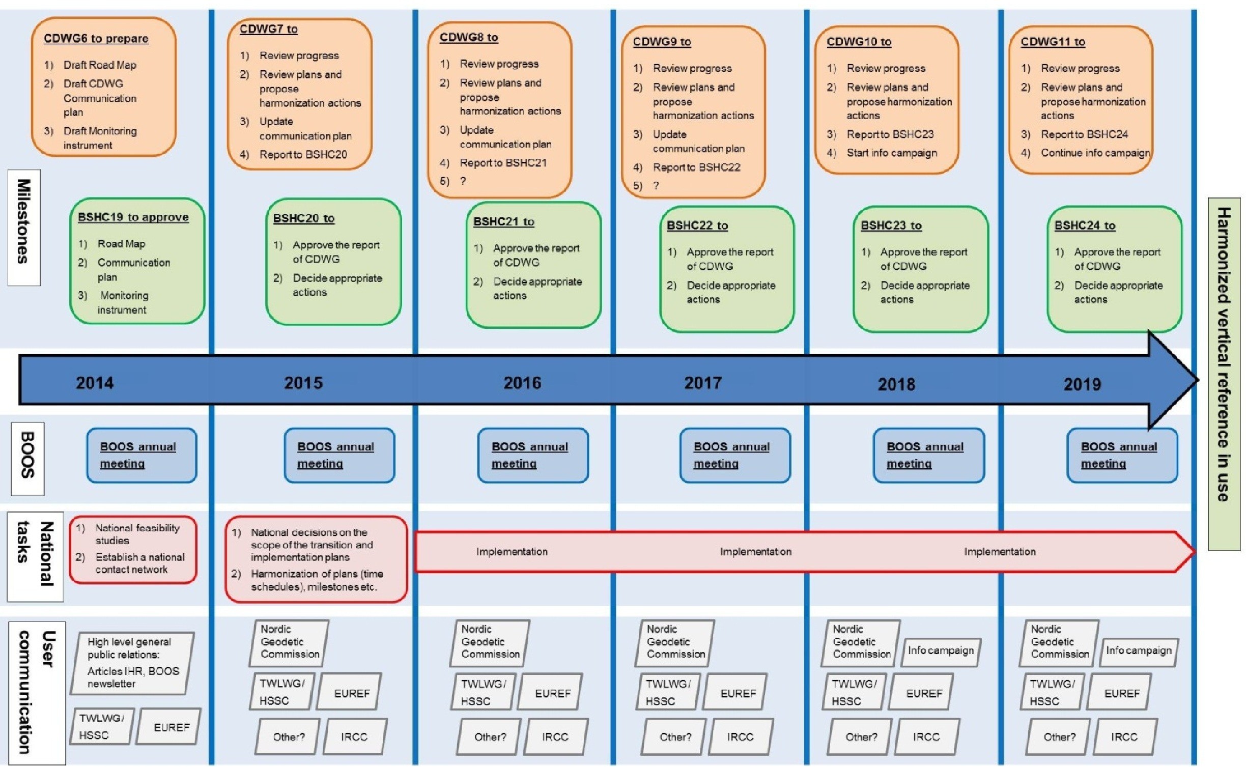
The CDWG will guide and follow-up the implementation process of the harmonized vertical reference system by preparing a roadmap time line (Figure 2) and monitoring the progress of the implementation process. Recommendations and guidelines on how the transition period could be implemented will be developed and if required, harmonisation actions will be proposed to be approved by BSHC.
Discussion
A harmonized vertical reference system enhances wider and easier use of the data in accordance with the INSPIRE directive and enables the full utilization of future enhanced navigation systems based on IHO S-100 standards.
The benefit for adopting the EVRS, is that it is a common European vertical reference system to which many national height systems are based on. Thus depths on sea and heights on land will be referenced to the same vertical reference system. The common levelling network around the Baltic Sea, Baltic Levelling Ring (BLR), computed and adjusted in 2006, provides the possibility to tie all mareographs to this common datum.
In the future navigation realm, i.e. the 3D-navigation can utilise ellipsoidal heights and accurate geoid models. Related to the harmonisation of a vertical reference, the CDWG will also study other water level related issues, e.g. possibilities to develop a common geoid model for the Baltic Sea and foster studies related to dynamic topography of sea surface in the Baltic Sea.
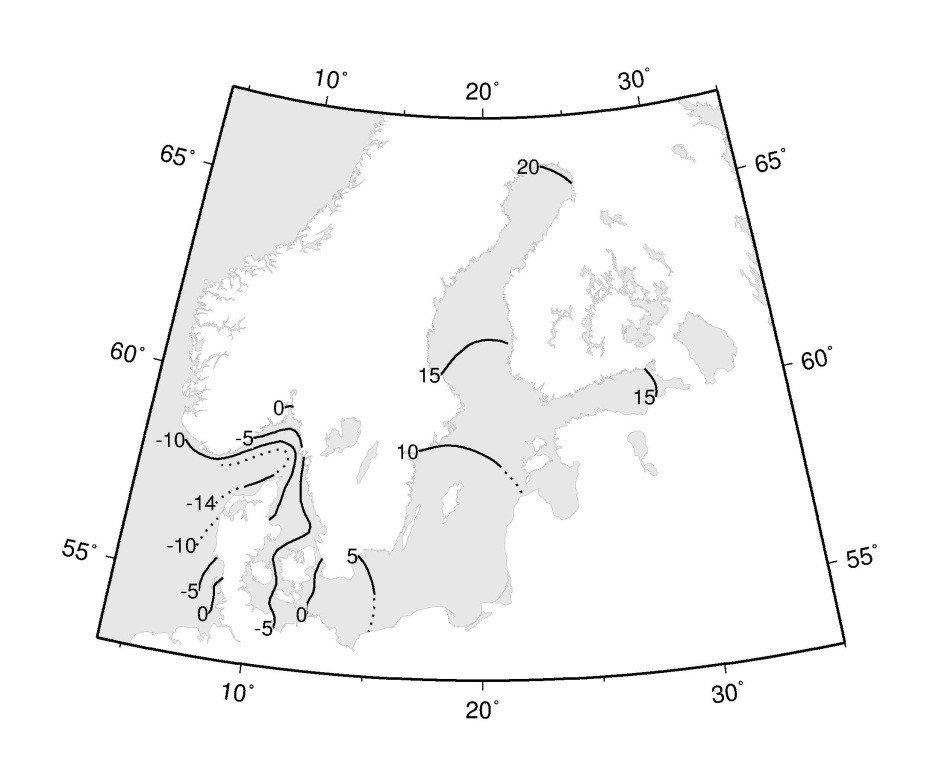
It is also important to understand the dynamic topography of the sea surface and how to predict water level changes to meet the future needs for more efficient and safer shipping. Figure 3 illustrates the Mean Sea Surface Topography. Improved water level information will enable shipping to improve its cargo carrying capacity whilst maintaining safer under keel clearances.
Reference
Ekman M. and J. Mäkinen, (1996) Mean sea surface topography in the Baltic Sea and its transition area to the North Sea: A geodetic solution and comparisons with oceanographic models. Journal of Geophysical Research: Oceans (1978-2012), Vol. 101, Issue C5, 15 May 1996, pages 11993-11999.
Biography
Jyrki Mononen has been working at the Finnish Hydrographic Office since 2006. He has been involved in acquiring hydrographic surveys, chart datum definitions and being responsible for the Finnish HO’s quality management system. Since 2013, he has been acting as the chairman of the BSHC CDWG. He has a MSc in land surveying from the Technical University of Helsinki in 1995.