

Abstract
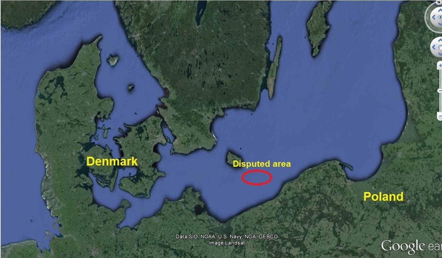
In 2011, during the 16th Baltic Sea Hydrographic Commission (BSHC) Conference in Norrköping (Sweden), Poland submitted for discussion and consideration the problem of surveying tasks in sea areas claimed by more than one coastal state. An example of this problem still exists between the Danish Bornholm Island and the Polish Coast in the Baltic Sea (see Figure 1). The Polish delegation presented the opinion that procedures for hydrographic surveys and general hydrographic tasks, done in disputed areas, should be worked out. In spite of the fact that Hydrographic Services have not been established to resolve disputes of any kind, which are in the domain of diplomacy, the Services (both Polish and Danish in this respect) remain responsible for surveying such areas. However, how can this responsibility be fulfilled when there are no procedures explicitly regulating particular hydrographic activities in these areas? If such circumstances sustain, sooner rather than later, the safety of navigation will suffer. The mentioned Zone is a result of the unsettled dispute between Poland and Denmark over limits of Exclusive Economic Zones (EEZ).
Both Polish and Danish Hydrographic Services are obliged to survey areas where the limits have been established by their respective national authorities. In the case of this particular Zone and unacceptable to each neighboring state, no rules apply. Even with no clear-cut limits, when it comes to paper charts, no problem exists as they not only cover national waters, but frequently waters of neighboring states as well. However, it is not the same when it comes to ENCs, surveys which collect data to update ENCs, or to Navigational Warnings Service. This situation becomes a matter of serious concern, since each state is responsible for its own area. Furthermore, this Conference agenda item was the result of concerns raised by the Hydrographic Office of the Polish Navy some years ago – how sea areas, claimed by coastal states, should be portrayed on paper charts because they have no relevant symbol in the S-4 Publication of the International Hydrographic Organization (IHO).
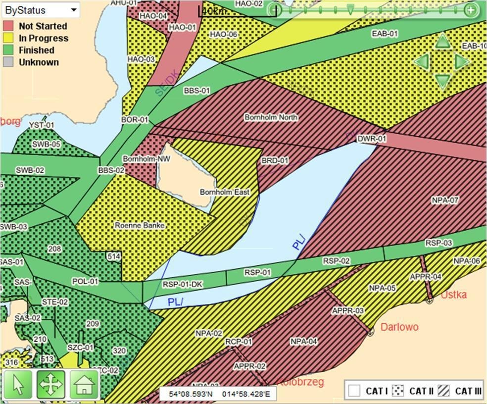
Due to the cooperation of both national Hydrographic Offices, this problem was solved last year when all the surveys, required to complete HELCOM routes, passing the disputed area, were completed (see Figure 2).
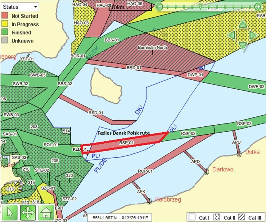
As a result of “hydrographic talks”, Denmark and Poland agreed to conduct a common survey of the route passing through the disputed area. Through diplomacy, a correct decision was reached in accordance with safety of navigation rules. They proposed that the best solution was to cut the disputed area into two parts, then survey and finally exchange the data (see Figure 3). The common understanding is that the survey effort bears no prejudice to any of the nations with regards to any future claims of the area.
This serves as a positive example of cooperation between Hydrographic Services, to solve a practical problem in an effective and successful way, thereby avoiding unnecessary problems for shipping in the area in the future.
Biographies
Commander Lars Hansen is the head of the Hydrographic Service in the Royal Danish Navy. His main field of expertise is shallow water and arctic bathymetry. Lars is currently posted at the Danish Geodata Agency, which is the agency responsible for charting in the Kingdom of Denmark. He has a broad practical experience as a Hydrographic surveyor and naval officer. His office is responsible for the planning and conduct of hydrographic surveys in Denmark and Greenland. Lars has been involved in IHO work since 2004. In this role he serves as an adviser to the National Hydrographer of Denmark and has participated in a number of working groups at the regional level. As a member of four regional Hydrographic commissions, Lars has a broad knowledge of what is going on in his region.
Captain (PN) Andrzej Kowalski is the National Hydrographer as the Chief of the Hydrographic Office of the Polish Navy since January 2014. During his naval career he served as Chief of Sea Training of the Polish Navy, Chief of Training and Deputy Commanding Officer of the 8th Coastal Defence Flotilla, Commanding Officer of the Hydrographic Squadron and Chief of Nautical Department and Deputy Chief of HOPN. He has participated in many national and international forums, representing the Polish Hydrographic Service in IHO, IMO and NATO Working Groups as well. He is decorated with numerous military and civilian medals.