
Abstract
At its 15th Conference, the Baltic Sea Hydrographic Commission (BSHC) decided to establish a working group on marine spatial data infrastructure (MSDI) with the task of promoting MSDI in the Baltic Sea region.
The working group’s focus is on national coordination of maritime information. Thus far, the group has conducted an in-depth survey of the participating countries’ respective approaches to coordinated access to maritime information. The study identifies areas where MSDI implementation is underway and where challenges can be foreseen.
Baltic Sea Marine Spatial Data Infrastructure Working Group (BSMSDIWG)
Background
At a time when the EU INSPIRE Directive (EU, 2009) is fully in its implementation phase across the European countries, and spatial data infrastructures (SDIs) are being developed worldwide at the national, regional and local levels, coordinated access to and management of geographic information has become standard. The IHO’s Marine Spatial Data Infrastructure Working Group has published C-17 – Spatial Data Infrastructures: The Marine Dimension – Guidance for Hydrographic Offices, which outlines the benefits of developing SDIs to reinforce coordination among maritime authorities (IHO, 2011). However, as the C-17 publication identifies, the integration of maritime data in SDIs has been limited at best, though there can be as many benefits to be gained by coordinated access to maritime information as to terrestrial data.
As coordinated maritime spatial planning also gains increased focus at the EU level, not least through the Integrated Maritime Strategy and the Marine Strategy Framework, the needs for better integration of maritime data are becoming increasingly evident. In Denmark, discussion has begun on the degree to which the maritime-oriented elements of the INSPIRE Directive can be implemented at an accelerated rate. Similar initiatives are expected to be underway across the Baltic Sea region.
In the future, we expect a growing demand for better coordination of the management of maritime information. While a national single window will aid in the reporting process among maritime stakeholders, the flow of information among the authorities is also a critical factor in ensuring the effective and efficient coordination of their work.
An MSDI ensures that relevant maritime authorities are able to contribute their spatial information and related updates in a way that they can be collated with other information to generate and maintain a current operational picture. The infrastructure is expected to support such applications as coastal zone management, planning of energy production at sea, fishery management, marine environmental protection and nature conservation, planning charts, navigation, civil and military preparedness, tourism, and future maritime spatial planning.
IHO Recommendations
The 18th International Hydrographic Conference (IHO, 2012) confirmed the importance of marine spatial data infrastructure (MSDI) activities for the IHO and its Member States as established at the 4th EIHC (IHO, 2009).
MSDI delivers the instruments for the enhanced scope of hydrographic information users. MSDI can create the framework for future provision of this information beyond the classic field of surface navigation. From an HO perspective, it is important that the IHO takes the lead in addressing MSDI matters for the maritime sphere through its MS; the MSDIWG is seen as an appropriate WG to deal with these opportunities, and the regional hydrographic commissions can be a platform for addressing regional MSDI issues through knowledge sharing, identification of best practice and pilot studies for exploring potential approaches to implementation.
In this context, and in order to promote an increased awareness of maritime spatial data infrastructure both within the Baltic Sea region and at the larger European scale, the BSHC launched its MSDI working group.
Responsibilities and activities of the working group
The remit of the Baltic Sea MSDI working group is to study how its members currently coordinate their national maritime information in order to identify areas where maritime SDI implementation is underway and where challenges can be foreseen. The study will result in a final report to the BSHC. This report is expected to include recommendations on how to proceed with MSDI implementation and an action plan with a specified time schedule for future MSDI actions in the region. The general activities and focus in the working group are further described below.
- Identify and analyse the current status of individual MS MSDI implementation.
- Consider MSDI policies within the related international project e.g. e-navigation, ICZM, INSPIRE, EU Integrated Maritime Strategy, the Marine Strategy Framework and EU Strategy for the Baltic Sea Region.
- Analyse how maritime authorities can contribute their spatial information and the necessary updates, so information can easily be collated with other information to a current overall picture for the region.
- Focus on how BSHC in the future can benefit from a regional approach.
- Monitor the development of SDI that could be relevant for the Baltic Sea.
First working group meeting – 2012
The work group launched its work with a workshop in Copenhagen in September 2012.
The first day of the workshop was intended to be a general presentation of the key elements of SDI, MSDI and INSPIRE. The second day of the workshop focused on the current status of the member countries’ MSDI and INSPIRE implementation. This assisted the working group members in addressing the level at which BSHC can benefit from a regional approach to MSDI in the future. Each participating country had the opportunity to give a short presentation on its national MSDI and INSPIRE implementation.
At the workshop, the working group also focused on future initiatives and the most important issues and challenges for future development of MSDI (from national and regional perspective). These were considered to be:
- Lack of awareness of MSDIs importance (and its linkages to INSPIRE) among potential MSDI stakeholders
- Lack of geo-related competence among potential users of an MSDI
- Determining what stakeholders there are for MSDI and assessing their requirements related to MSDI
- Producing adequate governance and agreements for MSDI development
- Lack of funding and human resources necessary for qualified MSDI development
- Finding consensus about which data should be fundamental to MSDI
- Organising and streamlining data sources between the contributors to an MSDI
- Lack of a clear strategy
- Ensuring existing initiatives aren’t duplicated
- Where to get started?!
Second working group meeting – 2013
The 2nd meeting of the BSHCMSDIWG took place in Copenhagen in 2013. The overall aim of the meeting was to create a common MSDI framework for the Baltic in order to establish an MSDI work plan for the Baltic Sea that focuses on how the BSHC can benefit from a regional approach to MSDI.
The meeting was conducted in two phases. The first included a general presentation from the IHO MSDIWG, national presentations from members on status of SDI, MSDI and INSPIRE implementation and a presentation of the proposal for a directive of the European Parliament and of the Council on establishing a framework for maritime spatial planning and integrated coastal management. The second phase of the meeting focused on a questionnaire on national use of marine data, the response from MSHC18 about MSDI and the creation of a draft work plan.
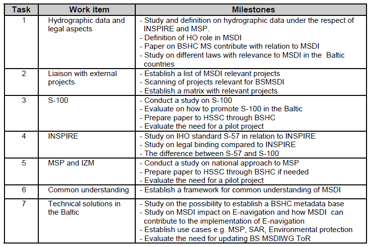
The resulting work plan focuses on MSDI-related tasks that are seen to be important and challenging from a regional and a national perspective. It includes seven work items, each of which includes relevant milestones. These are listed below.
The next meeting of the BSMSDIWG is planned to take place in the second half of 2014 in Germany.
Maritime spatial planning and integrated coastal management
The EU has recently published a proposal for a directive on establishing a framework for improved and effective maritime spatial planning in EU waters and integrated coastal management in the coastal areas of Member States. The main purpose of the proposed directive is to promote the sustainable growth of maritime and coastal activities and the sustainable use of coastal and marine resources.
The increasing and uncoordinated use of coastal and maritime areas results in competition for maritime and coastal space and inefficient and unsustainable use of marine and coastal resources. Uncertainties and lack of predictability on appropriate access to the maritime space has created a suboptimal business climate for investors, with potential job losses.
The proposal establishes a framework for maritime spatial planning and integrated coastal management in the form of a systematic, coordinated, inclusive and trans-boundary approach to integrated maritime governance. It obliges Member States to carry out maritime spatial planning and integrated coastal management in accordance with national and international law. The aim of the action is for Member States to establish a process or processes that cover the full cycle of problem identification, information collection, planning, decision-making, management, monitoring of implementation, and stakeholder participation.
The maritime spatial plans and integrated coastal management strategies will not set new sectorial policy targets. They have the purpose to reflect, integrate and link the objectives defined by national or regional sectorial policies, to identify steps to prevent or alleviate conflicts between different sectors and to contribute to the achievement of the Union’s objectives in marine and coastal related sectorial policies. Most importantly, the proposal requires Member State action to aim for coherence of management across sea basins, through trans-boundary cooperation in the same marine region or sub-region and related coastal zone and appropriate data collection and exchange.
Implementing acts will ensure consistent implementation of the Directive throughout the EU and facilitate reporting from the Member States to the Commission and, where relevant, the exchange of data between Member States and with the Commission. Article 10 in the proposed directive especially focuses on data collection and exchange of information. Article 12 and 13 describe Cooperation with other Member States and third countries.
Discussion
There are growing needs for better coordination of individual authorities’ management of maritime information. While a national single window can aid in the reporting process among maritime stakeholders, information flow among the authorities is also a critical factor for ensuring the effective and efficient coordination of their work.
An MSDI ensures that relevant maritime authorities can contribute their spatial information and related updates, and that this information can easily be collated with other information to generate a current operational picture. As a result, MSDI can support such varied activities as coastal zone management planning of energy production at sea, fishing, marine environmental protection and nature conservation, planning charts, navigation, civil and military preparedness, tourism, and maritime spatial planning.
From a more practical approach, there is a need to focus on and strengthen the maritime approach to MSDI and to insure that maritime information is included. Some of the challenges for BSHC MS in relation to MSDI reside in the needs to:
– Ensuring that Baltic HOs have the possibility to contribute to the development of the Baltic MSDI
– Ensuring the use of data/information provided by Baltic Sea HOs
– Ensuring that the Baltic Sea HOs have the possibility to contribute in creation of an Baltic MSDI reference model – A reference model that represents the component parts of any consistent idea, from business functions to system components
– Rules and rights in relation to the use of vector data between countries
– Establishing a structure to support the Baltic SDI
– Continuous updating of relevant data
– Clarify the financial aspect.
As seen from an HO perspective, the MS now have a direct possibility to actively participate in the development of a well-functioning MSDI within the hydrographic domain and its surroundings. This will generate the possibility to benefit from a national and a regional approach.
References
IHO (2009) IHO Resolution 5/2009 on MSDI policy, adopted by the 4th Extraordinary International Hydrographic Conference in June 2009, www.iho.int
IHO (2011) Spatial Data Infrastructures; The Marine Dimension – Guidance for Hydrographic Offices, IHO Publication C-17, Edition 1.1.0, www.iho.int
IHO (2012) 18th International Hydrographic Conference, Monaco, 2012, www.iho.int
EU (2009) EU INSPIRE Directive and respective national contributions of the MS, http://inspire.ec.europa.eu/
Biographies
Mr Jens Peter Hartmann is Senior Advisor at the Danish Geodata Agency witch also contains the Danish Hydrographic Office. He is the agency’s primary contact and coordinator for marine activities and involved in the implementation of a Danish Marine Spatial Data Infrastructure and Marine Spatial Planning. He is Chairman of the IHO Marine Spatial Data Infrastructure Working Group (MSDIWG) and Chairman of the Baltic Sea Marine Spatial Data Infrastructure Working Group (BSMSDIWG) under the Baltic Sea Hydrographic Commission.
He has previously been the Head of the Danish Hydrographic Office and served as Head of the Maritime Inspectorate at the Danish Maritime Administration. Jens Peter has also served as chairman for a working group under the Baltic Sea Hydrographic Commission that addresses the harmonisation of ENCs in the Baltic region and as an external lecturer at the Copenhagen Business School. Jens Peter is educated as a naval officer in the Royal Danish Navy and has worked as a master mariner in the commercial fleet and as a commercial pilot. Jens Peter holds degrees in organisation and strategy from Copenhagen Business School.