
Abstract
1. Introduction
The Bangladesh coast is located on the most active part of the Ganges Delta. The area is very shallow and a number of rivers and channels are situated along the coast. These rivers and channels carry huge amounts of water from upstream and flow into the Bay of Bengal throughout the year. The estuarine environment along the coast is different from other parts of the world. The water is exceptionally laden with sediment – mostly from the Himalayas. Annually, almost 2.4 billion tons (Coleman, 1968) of sediments are deposited in the Bay of Bengal. This deposition over the years has resulted in the Bay of Bengal being one of the most dynamic environments of world oceans.
The coastal area of Bangladesh has many notable physical characteristics such as the monsoon season, exceptionally high turbidity in the water, large tidal range along with strong tidal streams, tropical revolving storms, etc. The Monsoon causes heavy rainfall in the upstream from June to September each year with runoff into the Bay carrying large amounts of sediment. As the number and capacity of channels vary, there are inhomogeneous mélange of saline and fresh water along the coast. Spatial variation of salinity and temperature is prominent in the area. Various other characteristics that affect hydrographic surveying also differ from place to place.
Hydrographic surveying in the coastal waters of Bangladesh has never been an easy task for surveyors. Due to the unusual characteristics of the coast, most of the hydrographic equipment does not function to their optimum capacity. Sometimes, the degradation of performance is so prominent that the surveyors need extra time and effort to manage the survey work. Apart from the equipment performance, the prudence and professionalism of surveyors are critical factors to ensure the efficient progress of any survey work.
2. Description of the Coast
The extent of the coastal belt of Bangladesh is almost 710 km in an east-west and north-south direction (Golam Mahabub Sarwar, 2005). The coastline which runs in the north-south direction is relatively stable. However, the east-west coastline is highly dynamic. Hundreds of small islands and Low Tide Elevations (LTE) are situated along this coast. The area is very shallow and mostly inaccessible to medium and deep draft vessels. Most of the rivers which form the Ganges Delta fall into the Bay of Bengal through this area.
These rivers carry large amounts of sediment from upstream and deposit the sediment in the Bay. The result of this deposition is the rapid formation of new islands, LTE and shifting navigational channels. Two of the major sea ports of Bangladesh – Mongla and Payra are situated in this most dynamic part of the coast. These sea ports and their approaches require continuous survey to keep them accessible to sea going vessels.

3. Characteristics of the Coast
The coast of Bangladesh has a number of unique physical characteristics and phenomenon that makes the hydrographic surveying task highly challenging. Some of these are described below: (Figure 1 shows the main geographical features)
3.1 Tide
Accurate measurement of tidal levels is critical for all hydrographic survey tasks. Tides along the Bangladesh coast are mainly semi-diurnal with small diurnal inequality. Tidal range can reach more than 7m near the Sandwip channel, whereas, it is only 2-3 m on the western side near Hiran Point (BIWTA, 2015). The tide is significantly affected by local conditions such as the geomorphology, configuration and orientation of the coast, upstream flow of rivers, number of openings along the coast etc. As the coastal area is gently shelving and tidal range is high, tide gauges are needed to measure the tide. The offshore tidal range is larger than the onshore range in the central part of the coast which is a deviation from the normal phenomenon. The incoming tidal waters from the south are obstructed by the land features during flooding and the sea level rises very quickly. Time of rise and fall of tides also differs considerably in this region. For any hydrographic survey, much time is dedicated to collecting and analysing tidal measurements to ensure reliable tidal data.
3.2 Tidal Streams
Tidal streams in the coastal area of Bangladesh are very strong. In some areas it can reach up to 5.5 knots (BN, 2015), which makes the surveyor’s task very difficult. Strong tidal streams affect the speed of advance of survey motor boats and it is extremely difficult for the boat coxswain to steer the boat on the planned lines. The strong tidal streams also adversely affect the deployment and recovery of various equipment like Side Scan Sonar (SSS), Current Profiler, auto Tide Gauge, etc. Channels having multiple openings to the sea have peculiar tidal stream characteristics. In many channels, the direction of the tidal stream can be opposite within the same channel during the same tidal conditions.
3.3 Salinity
Salinity along the coast varies with strong gradients. There is fresh water influx into the sea from upstream. This mixing of fresh water varies with the number of channels present in the area as well as with the season of the year. During the monsoon, fresh water influx is considerably more than the dry season. Saline water of the sea is heavier than that of fresh water and hence it remains closer to the seabed. Fresh water coming from upstream remains above the saline water. This results in an inhomogeneous mixing of water layers around the coast. The surface salinity in the open part of the Bay oscillates from 32 to 34.5 ppt and in the coastal area it varies from 10 to 25 ppt. At the river mouths, the salinity decreases to 5 ppt or even less. Along the coast, salinity increases up to 15 to 20 ppt in winter (Firoz, 2007). If the surveyor is not careful, the error budget will increase and this creates difficulties in meeting the survey standard specified in S-44 (IHO, 2008) in terms of depth uncertainty.
3.4 Water Column Temperature
Temperature profile of the water column in the coastal area of Bangladesh is not homogeneous. Due to the influx of fresh water and the number of channels, the spatial variation of temperature is quite prominent and their discharge rate varies from place to place. This creates an inhomogeneous mixing of fresh water in the coastal area. The surveyor has to be very careful to ensure proper calibration of the sensors.
3.5 Turbidity
The coastal water of Bangladesh is heavily lad- en with suspended sediment. The cloudiness of this water especially during the monsoon is so high that it is impossible to see through it even for few centimeters. This extremely high turbidity degrades equipment performance. In many cases, the attenuation is so high, that sound energy is mostly absorbed and the equipment cannot perform as designed.
3.6 Monsoon Season
The Bay of Bengal is much affected by the monsoon with heavy rain fall experienced throughout the region. The runoff of water mostly drains into the Bay of Bengal through various river systems of Bangladesh. During the monsoon, turbidity around the Bangladesh coast increases and salinity decreases remarkably. The sea remains quite rough during monsoon which increases the risk for smaller vessels operating in the area. Survey vessels cannot operate during the monsoon season due to safety concerns of the survey motor boats and crew fatigue. This factor shortens survey operations time in the Bay of Bengal. The ideal survey season around the Bangladesh coast is during post-monsoon from November to March only.
3.7 Shallow and Indented Coast
The coastal area of Bangladesh is very shallow and indented in nature. Many of the inshore areas are inaccessible by survey vessel due to the presence of low tide elevation areas and shallow patches. Hence, the main survey vessel has to remain at anchor and send her boats for survey work to distant places. Variable and unpredictable sea conditions often make it very difficult to manage those boats and the progress of work is hampered. This also places the survey boats and teams at risk when returning to the mother ships.
3.8 Shifting Channels
Out of the three major sea ports of Bangladesh, Mongla and Payra ports are situated well inside the coast. So, any vessel coming to these ports need to traverse a long distance through inland waters. These navigational channels are highly dynamic and change al- most every year. Surveyors remain very active throughout the year to keep these channels safe for navigators.
3.9 Cyclone
During the pre and post monsoon period, tropical revolving storms (cyclones) are common in the Bay of Bengal. Every year a number of these cyclones hit the coast of Bangladesh often resulting in changes to the bathymetry of the coastal area with new islands and low tide elevation areas. South Talpatti was one such island that emerged after the cyclone of 1970 only to disappear due to the cyclone of 1985 (ITLOS, 2013). This island located at the mouth of the Hariabhanga River near the India-Bangladesh border area, had an area of 2,500 m2 in 1974 as per the satellite data released by USA. In the coastal area of Bangladesh, there are many such islands and low tide elevation areas which are created due to the devastating effect of cyclones that have occurred in the past. To identify these changes, frequent updating of the nautical charts is essential.
3.10 Presence of Fishing Fleets
The coastal area of Bangladesh is very rich for some species of fish. The vast majority of the coastal population lives on fishing. Apart from the licensed fishing fleet there are many conventional/traditional fishing activities all around the coast. Fishermen lay bamboo, different types of net and other gear in the sea which cause significant problems for navigation in the area. This fishing gear can also hamper survey operations in the area as many of the portable fixed and towed surveying instruments cannot be used for safety concerns.
3.11 Inaccessibility to the Coastal Area for Coastlining Activities
The coastal area of Bangladesh especially on the western side is mostly inaccessible. Shoreline and landform also change very rapidly in these places. The low gradient of the coast makes the intertidal zone quite large. In some places, there are marine growths as well as mangroves. It is almost impossible to walk along the coast. As a result, coastlining during hydrographic survey is a daunting task.
4. Overall Effect on Hydrographic Survey Operations
The characteristics of the Bangladesh coast described above significantly affects hydrographic surveying operations. Hydrographic sensors do not function as designed, the progress of survey work is affected by the inferior quality of data acquired using various equipment. Frequent re-survey/check surveys need to be undertaken given the changes that occur within short spans of time.
4.1 Equipment Performance
Various physical and environmental factors previously described affect the performance of hydrographic equipment while deployed in the coastal area of Bangladesh. The sensors mostly affected are:
4.1.1 Single Beam Echo Sounder (SBES)
SBES is widely used for bathymetric data collection during hydrographic surveys. SBES transducers can either be fixed on the ship’s hull or have a portable installation on boats/ survey crafts. In the coastal area of Bangladesh, a portable transducer installation is widely used on survey motor boats as the area is generally shallow. Performance of these echo sounders to provide depth information depends on many factors such as turbidity, tidal stream, water turbulence, bottom configuration, prevailing environmental condition, etc. Surveyors need to be cautious to understand the situation and to calibrate the echo sounder.
Sometimes, it is difficult to determine the actual bottom due to the presence of a column of soft mud near the sea bed. A dual frequency echo sounder helps in this situation to determine the actual bottom. Again, high turbidity in the water degrades the quality of data. During ebb tide, turbidity is higher as suspended sediments come from upstream. During the 3rd/4th hour of ebb tide when the tidal stream is stronger, the performance of the echo sounder is adversely affected. Sometimes the surveyor is forced to stop the data acquisition and wait for a more favourable condition.
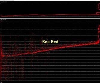
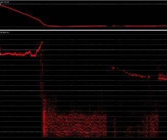
Figure 2 shows two echograms taken from a SBES profile near Sandwip Island where turbidity was very high and the tidal stream was very strong. The first echogram indicates the presence of noise which needs to be cleaned during processing. The second echogram indicates that bottom was lost and the echo sounder was unable to provide a depth reading. These are common phenomenon experienced.
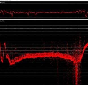
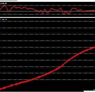
Figure 3 shows two echograms indicating the effects of turbidity. The first echogram was taken in Meghna Estuary where the sea bottom was composed of soft mud. The image of the sea bottom is almost 2m wide. So, it is very difficult to find the actual bottom. In this echogram there is considerable noise due to the presence of high turbidity. The second echogram was taken in the Cox’s Bazar area where the water is clean. The clean image of the echogram also confirms that there was no turbidity in the area.
4.1.2 Multi-Beam Echo Sounder (MBES)
Today, MBES technology is extensively used in hydrographic survey operations. MBES gives detailed information of the seabed and many hydrographic offices prefer to use this equipment at least for some important places of their waters such as port and harbour areas, their approaches, etc. Performance of this equipment in the coastal area of Bangladesh is highly affected by the local conditions. Due to the inhomogeneous mixing of fresh and salt waters, the sound velocity profile is unusual which impacts the calibration and performance of this equipment significantly. Again, due to turbidity, optimum swath coverage is not always attainable as the beams are concentrated towards the centre. The quality of collected data is often poor and requires extensive cleaning during processing. Like SBES, MBES also provides improved performance during flooding when turbidity is comparatively less in the area.
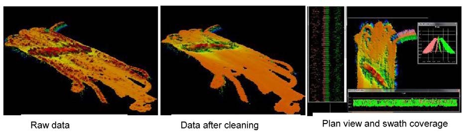
Figure 4 shows MBES data collected from Chittagong Port anchorage area at a depth of 9m during ebb tide in the month of April when the upstream discharge was quite high. Due to the presence of high turbidity and an unusual salinity profile, the raw data has significant noise. Even after extensive cleaning, the image of the wreck is not smooth. In the plan view, it is evident that beams are also concentrated towards the centre and swath coverage is 12m only. As per the equipment specification, the optimum swath coverage at 9m depth should be 90m.
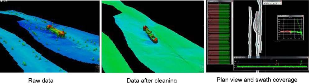
In comparison to the data shown in Figure 4, Figure 5 shows MBES data collected near Cox’s Bazar at a depth of 9m during flooding in the month of February when the upstream discharge was less. During this time, turbidity was less in the area. The raw data has less noise and the image of the wreck is quite smooth after cleaning. Here the swath coverage is almost 46m which is far better than the previous case.
4.1.3 Side Scan Sonar (SSS)
To comply with S-44 special order and order 1 (a) survey (IHO, 2008), full sea floor search is required during bathymetric survey. SSS plays a very important role for underwater search and detection of wrecks, obstructions etc. The performance of this equipment is also dependent on the environmental conditions. The SSS image is often not clear enough if the turbidity is very high. The operating range of the equipment also reduces significantly in such cases. Moreover, due to the presence of fishing gear all around the coastal area, it is not safe to operate the equipment in shallow waters. To overcome these limitations, the low upstream discharge period is selected for SSS operations and the area is cleared before lowering a towfish in the water.
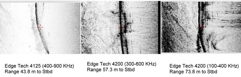
Figure 6 shows SSS images taken at the Chittagong outer anchorage on a known wreck where turbidity is exceptionally high. In ideal conditions, the definition of an image collected using a higher frequency would be better. In the third image, which is collected using a lower frequency, the wreck is more visible than in the other two. Transmitted energy is considerably absorbed by turbid water in the higher frequency. For that reason, even the first image, whilst taken from a closer distance, is not clear enough. Sometimes, the performance of high frequency equipment degrades so much that the feature is not visible on the image at all.
4.1.4 Current Profiler
For most hydrographic survey tasks, a current profiler is deployed for measuring tidal streams to depict on nautical charts. The quality of the collected data is influenced by the local conditions and noise to signal ratio is often higher than the normal level. It is difficult to deploy the equipment as the tidal stream is exceptionally strong in some places of the coast. Sometimes the equipment is snagged by fishing operations and lost, hence extra precaution is always needed while deploying this equipment.
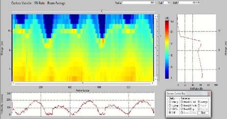
Figure 7 is a profile taken using a Sontek Current Profiler (500 KHz) near the coast of Bangladesh. In this image, the current velocity and Signal to Noise ratio (SNR) is visible. Maximum profiling range of this equipment is 120m in ideal conditions. Data less than 3dB cannot be used as it determines the maximum profiling range of the equipment. It can be seen that SNR is close to 0 dB beyond 10m-12m depth. Again, during slack water, the cut off line for 3dB extends beyond due to the presence of high turbidity in the water columns.
4.2. Re-survey/Check Survey
As the area is very dynamic, frequent check/re-survey is required along the coastal area of Bangladesh. The area is dangerous with high risk of grounding if mariners do not use the latest charts available from the Bangladesh Hydrographic Office. Due to the physical conditions, even the main shipping channels shift within a very short time span (see Figure 8). The figure is an extract of INT 7426 showing the approaches to Mongla Port. A marked change in the bathymetry is visible in the two images. These changes in the channel took place within a time span of 3-4 years. A number of vessel groundings were reported in the area in last few years where vessels were found to not have the latest updated chart.
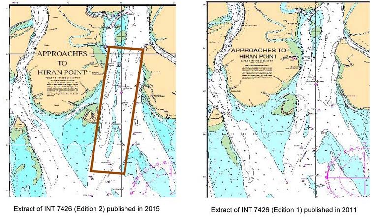
This makes it challenging for the national hydrographic office to manage the area with limited resources. Moreover, time available for survey operations is also limited due to the monsoon and other local factors mentioned before. The Bangladesh Hydrographic Office always remains busy to plan the survey activities of the area in the most effective way to keep it safe for mariners.
Figure 9 shows the area representing the main shipping route for Chittagong port on two products – BA 859 dated 2002 and BN 40001 dated 2009. On 28 March 2010, MV St Kiril grounded in position 21°35.4’ N, 091°44.8’ E where BA 859 chart shows a depth of 14m. However, bathymetry in that area changed considerably over the period and the recent edition chart published by BN indicates lesser depth in the same position. The vessel grounded for not following the most updated national BN chart available for the area.
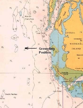

Figure 9: . Inconsistency in depiction between various chart products of differing HO maintenance programmes
4.3. Unsuitability of Modern Surveying Techniques
Undertaking hydrographic surveys with traditional survey technology and methods is a costly activity. Surveyors remain in the survey ground day after day with their vessels and work day and night to process the data for producing nautical charts. Presently, there are also modern techniques like LIDAR and Satellite Derived Bathymetry. These techniques have the inherent advantages of collecting data with less cost and time. However, these techniques are not suitable for the Bangladesh coast due to the turbid water heavily loaded with sediment.
5. Approach to the Problems
Hydrographic survey operations are not easy to perform in the coastal area of Bangladesh.
However, as a signatory of the SOLAS convention, Bangladesh is committed to providing updated hydrographic information to mariners as per the IHO’s S-44 standards (IHO, 2008). The following aspects are always considered both by the national hydrographic office and the surveyors whilst surveying in this dynamic environment:
- To ensure quality of the collected bathymetric data, extra effort is taken when measuring the sound velocity profile, tide and tidal streams in the area. Sound velocity profiles are collected at short distances to minimize errors.
- Frequent check survey/re-survey is undertaken to identify seafloor changes so that the mariners have confidence when navigating in the area.
- The whole year is not suitable for survey operations due to various factors that prevail in the area. To overcome this issue, increased numbers of survey platforms are being used during the suitable times of the year. BN requires the use of five survey ships/crafts to cover a small area of its jurisdiction.
Most of the equipment does not function to their optimum capacity in the area. To overcome this limitation, the highest quality equipment is used. Best results are achieved by combining the best quality equipment, sound survey methods and the dedication, commitment and experience of BN surveyors.
BN puts considerable resources into training activities. Much of the year is dedicated to training which ultimately improves the competence and confidence of the surveyors to ensure high quality survey results can be achieved for this dynamic environment.
6. Conclusions
Being situated in a deltaic region, the coastal area of Bangladesh is very dynamic. Siltation, shifting channels, emergence of new islands and low tide elevations, etc. are common phenomenon in the area. In addition to common deltaic conditions, there are many local conditions which are peculiar to this area. The coastal water is exceptionally laden with sediments coming from upstream and therefore, turbidity is extremely high. Monsoon in the region causes extra rain fall which makes the water characteristics for surveying more complex. The seasonal cyclone adds another dimension to the complexity of the area. Salinity in the area is not homogeneous and the temperature profile through the water column varies from place to place. It is very difficult to quantify the changes of these two parameters in the coastal area of Bangladesh. High turbidity degrades the performance of survey equipment. Even the most sophisticated state-of-the-art hydrographic equipment does not function as well as expected. Measurement of tidal level heights and tidal streams is also challenging. The deployment and recovery of survey equipment such as current profilers, automatic tide gauges, side scan sonar, etc. is difficult and the safety of equipment is a major concern for the surveyors. All these factors increase the difficulty to the surveyors while conducting hydro- graphic surveys in the area.
As a signatory to the SOLAS convention, Bangladesh is committed to provide up to date information to mariners. Frequent re-survey/check survey are conducted to delineate the changes. Extra efforts are provided for measuring sound velocity and temperature profile while conducting hydrographic survey. Additional resources are used for a comparatively small area. Extensive training activities are conducted so that the surveyors can maintain their competencies and perform their duties in a difficult environment to ensure survey quality requirements are met. Above all, the prudence, professionalism and dedication of the surveyors are one of the key factors for the successful hydrographic management of the area.
7. References
BIWTA (2015). Bangladesh Tide Tables, 2015, pp 1-6 and 43-48.
BN (2015). Chart 25002, Ed. 2, 8 October 2015.
Coleman, J.M. (1968). “The Sediment Field of Major Rivers of the World”, Water Resources Research, Vol. 4, No. 4, pp. 26-59.
Firoz Ahmed, S. (2007). “Surveying in the Ganges Delta Region”, Dissertation for M.Sc. in Hydrographic Surveying, Goa University, India, pg. 13.
Golam Mahabub Sarwar, Md. (2005). “Impacts of Sea Level Rise on the Coastal Zone of Bangladesh”, Masters Thesis, Lund University, Sweden, pg. 4.
IHO (2008). S-44 – IHO Standards for Hydro- graphic Surveys, International Hydrographic Organization, Ed. 5, Monaco.
ITLOS (2013). Arbitration under annex VII of the United Nations Convention on the Law of the Sea (UNCLOS), People’s Republic of Bangladesh v Republic of India, Reply of Bangladesh, Vol. I, 31 Jan 2013.
8. The Author Biography
Commander Sheikh Firoz Ahmed, (H1), psc, BN joined the Bangladesh Navy on 01 July 1992. He received the gold medal for outstanding performance during naval officers basic training. He completed his “Cat. B” hydrographic course from ‘Ecole des Hydrographes’, EPSHOM, France. He also completed his Cat. A Hydrographic course from the National Institute of Hydrography, India. He obtained his Masters in ‘Hydrographic Surveying’ from Goa University, India with distinction. He is a graduate of Defence Services Command & Staff College, Mirpur, Dhaka.
Cdr Firoz commanded a number of BN Hydrographic ships including BNS DARSHAK, BNS TALLASHI, BNS AGRADOOT, BNS SHAIBAL and BNS ANUSHANDHAN. During his tenure on board BNS TALLASHI and BNS AGRADOOT, he conducted bathymetric surveys in the western area of the Bangladesh coast near the Sundarban mangrove forest. As the commanding officer of BNS SHAIBAL and ANUSHANDHAN, he conducted a number of shallow water hydrographic surveys in the central and east coast of Bangladesh. He was involved in the survey of the newly built Payra port approaches which is a very dynamic area of Bangladesh coast. Cdr Firoz also served at the Naval Headquarters as the Deputy Director of Hydrography. There he was involved in the planning of hydrographic activities as well as the management of BN hydrographic resources.