
Abstract
1. Introduction
According to what has been agreed within the scope of the Commission on the Limits of the Continental Shelf, the Brazilian maritime limits comprise a jurisdictional area of over 4.5 million km2. The physical knowledge of this vast area coupled with 40,000 km of inland navigable waters, presents a significant challenge to the Brazilian Hydrographic Service. This challenge is aggravated by shrinking financial resources intended for research. This resourcing issue is common all over the world, especially in countries that are still striving for their full development, which is the case of Brazil.
Up to the end of 2014, the Brazilian Directorate of Hydrography and Navigation (DHN) had six research ships over 1000 ton and nine ships between 100 and 1000 ton. Most of these vessels were built at a time when the ships were conceived for an exclusive purpose (either hydrography or oceanography) and were normally used by only one institution. The gradual need for the change of these ships came together with the change of those concepts of exclusive purpose and use. Studies and proposals from within the Brazilian government comprised three projects for the purchase of research ships for multiple purpose operations and one of them to be used for the benefit of multiple institutions.
From these projects, eight vessels were purchased as follows:
a. One ship to survey the offshore maritime area. This purchase involved a partnership with four governmental organizations. The ship was named “Vital de Oliveira”, after the patron of the Brazilian Hydrography, Commander Vital de Oliveira.
b. Five ships to survey the Amazon Hydrographic Basin. These vessels work in partnership. The larger ship provides logistic support to the smaller vessels. The smaller vessels carry out the research wherever the larger vessel cannot go due to its draft and size.
- one 610 ton ship, named “Rio Branco” after the Brazilian diplomat who consolidated the borders of the country, and
- four smaller ships, named after the emblematic rivers of the region – “Rio Negro”, “Solimoes”, “Xingu” and “Tocantins”.
c.Two ships to survey the Pantanal Hydrographic Basin:
- one 100 ton ship, named the “Caravelas”, to pay homage to the city near which a naval combat was fought between the Brazilian and the Portuguese forces in 1823, the so-called “War of Independence”; and
- one small hydrographic motorboat called “India”, equipped with a multi-beam echo sounder.
The governmental organization in charge of the Brazilian waterway transportation took part in this project.
2. Hydro-oceanographic Vessel – “Vital de Oliveira”
The Hydro-Oceanographic research ship “Vital de Oliveira” (see Figure 1) was launched on 28 September 2014, at the Guangzhou Hantong Shipbuilding and Shipping Company, in Xinhui, the People’s Republic of China. It was introduced into service for the Brazilian Navy on 24 March 2015 during a ceremony held in Singapore and presided over by the Chief of Staff of the Navy, Admiral Wilson Barbosa Guerra.
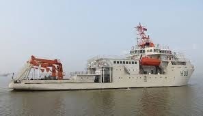
The ship has five laboratories, two are wet and three are dry. She is equipped with the most advanced technology in hydrography and oceanographic research. A highlight of this technology is the remotely operated vehicle (ROV) which can work at depths up to 4,000 meters.
Equipped with multi-beam echo sounders for shallow, medium and deep waters, the “Vital de Oliveira” will increase the capacity of the DHN in surveying, mapping and charting the national Territorial Sea, Exclusive Economic Zone (EEZ) and the extended Continental Shelf. She will also allow for the improved ensonification coverage of the seabed in strategic regions for the naval power and critical safety of navigation areas. Moreover, the ship can accommodate 40 researchers in addition to the crew of 90 military men and women. The ship can also be used in scientific research for the physical, chemical, biological, geological and environmental characterization of the Brazilian jurisdictional waters. The characteristics of the “Vital de Oliveira” are:
- Length: 78m
- Breadth: 20m
- Displacement: 4,200 ton
- Loaded draft (with gondola): 6,3m
- Deep load draft (with gondola): 5,3m
- Endurance: 30 days
- Fuel: 560 ton
- Water storage capacity: 125 ton
- Cruising Speed: 10 knots
- Maximum speed: 12 knots
- Crew: 90
- Researchers: 40
- Dynamic Positioning System: DP2
Scientific Equipment:
- Multi-beam Echo Sounder: Kongsberg EM 122 (12 KHz) and EM710 (70-100 KHz)
- Single beam Echo Sounder: Kongsberg EA600 (12, 38 and 200 KHz)
- Sub Bottom Profiler: Kongsberg SBP 120 (2,5 to 7,0 KHz)
- Side scan sonar (SVL): L-3 Klein 5000v2 (455 KHz)
- Current Profilers (ADCP): 75,150,300,600 and 1200 KHz
- CTD/Rosette, U-CTD, XBT and MVP300
- Remotely Operated Vehicle (ROV) and TV-GRAB operating depth: 4,000m
- High precision acoustic positioning system (HPR): HIPAP 501
- Bottom samplers: piston core, box core and Van-Veen
- Weather Station: Vaisala WAMS-410
The Brazilian Hydrographic Service, an organization under the Brazilian Navy, operates the “Vital de Oliveira”. Her missions, however, will support other organizations that are also interested in maritime data and contributed to the acquisition project. These organizations include the Ministry of Science, Technology and Innovation (MSTI), the private mining company Vale and the State-owned oil company Petrobras.
The acquisition of the ship was possible due to the integrated efforts of the above mentioned institutions. She will set a new level of effectiveness in the collection of hydrographic, geological, oceanographic and meteorological data in the South Atlantic and in the waters under Brazilian jurisdiction.
3. Fluvial Hydro-Oceanographic Vessels
The project for the construction of one large ship and the four smaller vessels was developed in partnership with the governmental organization known as the Center for the Management and Operation of the Amazon Protection System (CENSIPAM). This project was initiated to update the national cartography within the vastitude of the Amazon region.
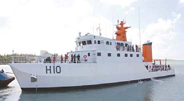
The “Rio Branco” (Figure 2) is able to carry out hydro-oceanographic surveys, comprising such diverse activities as bathymetry, physical oceanography and meteorology. She is called a fluvial ship due to its hull, which has been designed to operate in the rivers within the Amazon region. Her endurance is outstanding and she is able to navigate extensive distances without land logistic support.
The characteristics of the “Rio Branco” are:
- Length: 46,3m
- Breadth: 8,5m
- Draft: 1,7m
- Crew: 51
- Maximum speed: 12 knots
- Endurance: 25 days
- Range: 3.000 nm
- Loaded displacement: 610,6 ton
Scientific Equipment:
- Multi-beam Echo Sounder: Kongsberg EM2040
- Single Beam Echo Sounder: Kongsberg EA 400
- Positioning System: C-NAV RTG 2050
- Side Scan Sonar: Edgetech 272TD
- Gyro-Sensor GPS: Seatex Seapath 200
- Motion Sensor: Seatex MRU5
- Weather Station: Vaisala WAMS-410
- Rossette-CTD Seabird SBE32-SC and SBE19-plus
- ADCO portable Teledyne RDI WHM-600-RG
The four smaller Fluvial Hydro-Oceanographic Vessels “Rio Negro”, “Solimoes”, “Xingu” and “Tocantins” (Figure 3) are able to carry out hydrographic and oceanographic surveys. They also have an efficient hull design for the operational conditions suited to the Amazon region. Their small sizes and shallow drafts enable them to perform operations in shallower depths than those of the “Rio Branco”. Their endurance is however shorter and they are able to only navigate short distances.

General characteristics of the Fluvial Hydro-Oceanographic Vessels are:
- Length: 24,5m
- Breadth: 6,5m
- Draft: 1,4m
- Crew: 11
- Maximum speed: 10 knots
- Endurance: 10 days
- Loaded displacement: 145,9 ton
Scientific equipment:
- Single Beam Echo Sounder: Kongsberg EA 400 double frequency
- Positioning system: DGPS C-Nav RTG 2050
- Weather Station: VAISALA WAMS-410
Distances are the greatest operating factors for these ships. Table 1 and Figure 4 show the distances, in nautical miles, between the main ports, logistic base and international borders:
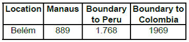

One of the key factors of considerable importance is the variable environment experienced throughout the Amazon basin. It affects capacity for fluvial transportation, which is indispensable to this region.
Some areas completely change their bathymetric configuration in an average period of six months.
The Cartographic Plan for the Brazilian Amazon region contains 185 nautical charts with variable dimensions and scales. They are subject to constant updates due to a series of variables related to the hydrographic dynamics of the rivers including:
- formation of shoals along all the water-ways, mainly caused by riverbank collapses;
- change of the design of the channel of navigation due to changes of the shoals; and
- the significant amplitude in the imbalance in the water levels in times of floods and droughts.
These factors generate the need for a constant monitoring of the depths. Since the rivers of the Amazon basin are young and highly variable, it is mandatory to carry out at least one bathymetric survey a year, preferably during the period opposed to the rains and floods. This occurs at different times in the tributaries of the left and right margins of the main rivers, the Solimoes and the Amazonas. Another relevant factor is the impact of the tides, which is felt even 500 miles inland from the river mouth. Finally, the social and economic aspects are also impacted by the dynamics of the environment.
The Amazon export trade is responsible for almost 20% of the total volume of the Brazilian export trade. Almost all export trade is transported through fluvial-maritime routes. The social aspects are related to the fact that the waterways are the most important means of communication within the region as most of the cities and villages are located at the margins of the rivers, and there are hardly any roads and airports. The waterways in many cases provide the only means of integration of the region to the other parts of Brazil and are of crucial importance to international integration. The traffic of SOLAS ships transporting Brazilian, Peruvian, Colombian and Venezuelan products increases every year. This consolidates the Amazon waterways as an important connection between the Pacific and the Caribbean countries with the Atlantic.
Besides these five vessels, another two ships also operate in the region. Of seven ships, four are based in Belém, and the other three in Manaus.
4. Fluvial Hydro-Oceanographic Vessel “Caravelas”
On 22 April 2014, the Fluvial Hydro-Oceanographic Vessel “Caravelas” was introduced into the Brazilian Hydrographic Service with the following characteristics:
- Length: 25,84m
- Breadth: 7,0m
- Draft: 0,79m
- Crew: 14
- Cruising speed: 7 knots
- Range: 800 nm
- Loaded Displacement: 100,36 ton
Hydrographic survey operations within the region comprising narrow and shallow rivers are undertaken using a hydrographic motorboat that is towed by the “Caravelas” to the area of the survey. This motorboat is fitted with a Kongsberg Multi-beam Echo Sounder EM3040 Dual Head. The “Caravelas” is capable of processing the collected data while the motorboat surveys.
The “Caravelas” operates within a waterway that cuts South America in a north-south direction. This 3,442km waterway runs from the city of Nueva Palmira in Uruguay to the city of Cáceres in Brazil. The waterway encompasses the two main rivers of the La Plata Basin – the Paraguay and the Paraná Rivers. These rivers are characterized by their great sinuosity and the average depth of 5 to 6m. Their waters in the Brazilian territory cover over 1,000 kilometers and are continually enlarged in the north-south direction by the tributaries.
With the variable declivity ranging between 1 and 2 cm per kilometer and in the north-south direction, the plain and low lands are inundated during the season of floods. These waters drain slowly from the plains toward the riverbeds during the dry periods, leaving a fertile environment behind for plants and animals.
Due to the proximity of the waterway to regions that are rich in the production of ore and grains, large, fully loaded convoys depart from terminals located mainly in Corumbá (Brazil), heading to the important Mercosur capitals (Asuncion, Buenos Aires and Montevideo). Part of the fluvial waterway is subject to the SOLAS regulation. Parts of the waterway also determine the borders between Argentina, Brazil, Bolivia, Paraguay and Uruguay and makes for the straight connection between the Brazilian Middle West region and the countries situated in the heart of South America – Paraguay and Bolivia – with the Atlantic Ocean. The acquisition of the “Caravelas” will contribute to the ongoing integration between the Brazilian Hydrographic Service with other agencies from Paraguay and Bolivia and will improve prosperity and safety of navigation of the fluvial traffic.
5. Conclusion
With the acquisition of new hydro-oceanographic vessels, the Brazilian Hydrographic Service continues to meet its surveying and charting responsibilities within an extensive maritime and inland water domain. Amongst tight budgetary restrictions, the acquisition process for the new vessels was to fundamentally update, improve and optimize the operational capabilities of the current research ships.
The collaborative efforts of various private and government stakeholder organizations led to the success in acquiring these vessels. These organizations are key stakeholders in maximizing the use the ships and sharing the ongoing research results. Such cooperative efforts will provide significant benefits to the neighboring countries of the fluvial basin of the Amazon and the Pantanal, as well as to those countries that share our borders of the South Atlantic.
6. Biography
Admiral Luiz Fernando Palmer Fonseca was born in Rio de Janeiro, Brazil, and joined the Brazilian Navy through the Naval High School when he was 16 years old. He graduated as Midshipman in the Brazilian Naval Academy in 1971 and first served on the Hydrographic Ship “Canopus” prior to specializing in Hydrography. This exposed him to hydrographic survey work performed in various coastal regions especially at the mouth of the Amazonas River. Later in his career, he would return to serve as the Head of the Department of Hydrography and as Captain of this ship.
He finished the hydrography course in 1975 and served as the Head of the Department of Hydrography of the Hydrographic Ship “Taurus” and as Commander of the Buoy Tender “Mestre João dos Santos”. He then undertook a General Staff course and took command of the Hydrographic Ship “Orion” and later the “Canopus”. Having spent much of his career on board survey ships, he under- took numerous surveys of Brazilian maritime and river nautical charts.
As Captain, he was the CEO of the Brazilian Aids to Navigation Center and as Admiral, was Director of the Sea Studies Institute “Admiral Paulo Moreira” for two years. For almost four years, he was the Director of Hydrography and Navigation (National Hydrographer).
His career in the Navy ended as the Chief of Naval Operations and Director-General of Navigation. Admiral Palmer is currently the Advisor of the Directorate of Hydrography and Navigation (DHN) to institutional affairs.