
Conducting hydrographic surveys is one of the main tasks that SHOA executes to obtain the necessary data required to produce nautical charts for the establishment of safe navigation routes of the waters along their extensive national coastline. The SHOA National Nautical Cartography capability provides an outstanding service that is of the utmost importance to Chile’s socioeconomic development.
Navigation, shipping, fisheries and aquaculture; nautical sports; tourism; national security and defense; search and rescue operations, maritime boundary delimitations; the management and the development of the coastal zone and marine scientific research, among other activities, cannot be conducted safely if reliable and up to date nautical charts are not available.
The nautical chart is a dynamic representation of the geographic characteristics of an area. Charts need to be updated due to the variability of the sea floor morphology, produced by currents and coastal processes of erosion and silting, and particularly in the case of Chile, due to the seismic activity. Improvements to charting coverage and data quality are the result of constant improvements in the technology used (e.g. instruments and methodologies) to collect and process hydrographic data.
For SHOA’s mission to be possible, it must have an adequate capability to conduct hydrographic surveys.
“LH-02” Hydrographic Launch Commissioning
In a ceremony led by Vice Admiral Osvaldo Schwarzenberg, Director of the General Directorate of the Marine Territory and Merchant Marine, on 11 December 2015, at the facilities of the Higuerillas´ Yacht Club, the “LH-02” Hydrographic Launch was officially commissioned into SHOA’s operational resources.
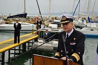
The Director of the SHOA, Rear Admiral Patricio Carrasco expressed: “This new boat, equipped with hydrographic equipment of the latest generation, will allow and contribute to, among other activities, the detailed investigation of the marine bottom, in areas near the coast, between depths of 10 and 200 meters, covering areas where access by larger hydrographic survey platforms becomes difficult and risky”.
Characteristics
The Defender-type Hydrographic Launch “LH-02”, was acquired from SAFEBOATS International Company, Bremerton WA., USA, and adapted to fulfill the role of a hydrographic survey boat. The hull is aluminum; 8.2m in length; 2.6m maximum beam; displaces 3,713 tons with a maximum speed of 46 knots and a cruising speed of 35 knots. It can be transported by land or air when the operational area cannot be reached by sea. The hydrographic equipment installed consists of a multibeam sonar, a motion sensor, a profiling probe (CTD) and additionally can support a side scan sonar (SSS).
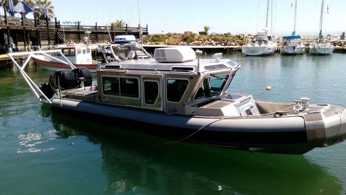
All these instruments will allow the collection of detailed seabed information in the areas close to the coast. This information will help to supplement other information required to produce nautical charts by SHOA.
Costs
The boat, including its trailer for towing and conditioned for the survey systems cost 325 million dollars CLP. The referential cost of a RESON 7125 was 235 million dollars CLP. The remainder of the hydrographic survey equipment, the integration of which was carried out in Chile, had a cost of 80 million dollars CLP. The total cost of the critical spare parts acquired was 41 million dollars CLP.
Equipment
The hydrographic equipment includes:
- Multibeam Sonar: allows for the sweep of the seabed to characterize its geomorphology;
- Motion Sensor: allows for the compensation of errors generated by the movement of the boat during its operation, obtaining reliable vessel positioning and reference information;
- Profiling probe: measures water column characteristics to determine the sound velocity in water to adjust the multibeam sonar to the existing conditions.
There is also the capacity to operate a portable Side Scan Sonar (SSS) system. The SSS generates high resolution images of the sea floor geomorphology, viewing towards both sides of the navigation route, thus complementing the multibeam sonar measurements.
“LH-02” complements the existing means for SHOA to carry out hydrographic surveys. Given its characteristics, the assigned operational areas include mainly those close to the coast, between depths of 10 to 200 meters. These are areas where hydrographic operations become difficult and risky to conduct by larger survey ships.
The inclusion of “LH-02” will impact the working plans of SHOA’s hydrographic survey program. To fully achieve this program, SHOA now has access to the latest generation tools that allows an increase in operations’ effectiveness. “LH-02” has no operational seasonal limitations and will actively participate and contribute to the annual programming of hydrographic surveys. The sea keeping conditions of the boat will enable sustained, stable and steady operations. Her speed makes “LH-02” an effective tool to arrive promptly to the working area and to cover the bathymetric surveying operations in a reasonable time. Her size and weight allows for transportation by land or air, improving flexibility to reach the area of operation particularly where sea access is not possible.
“LH-02” will not only contribute to the collection of bathymetric information required for the production of nautical charts, but has the potential, given her speed, to quickly respond and conduct search and rescue operations for aircrafts and vessels in waters of up to 200 meters deep.