
By the Japan Hydrographic and Oceanographic Department
Abstract
The Hydrographic and Oceanographic Department of the Japan Coast Guard (JHOD) has been conducting airborne lidar bathymetry (ALB) for 14 years. Owing to ALB’s survey efficiency and high resolution, JHOD has applied the technique to various purposes such as, to say nothing of charting, recovery of tsunami-stricken harbors, surveillance for security, and research into volcanic activity. This note briefly describes the operation of the JHOD lidar system and outlines our typical outcomes.
1. Introduction
The Japan Coast Guard (JCG), an external agency of the Ministry of Land, Infrastructure, Transport and Tourism, is responsible for maritime safety and security in Japanese waters. The Hydrographic and Oceanographic Department of the JCG (JHOD) is mandated to publish nautical charts around Japan to ensure navigational safety for mariners. In relation to the hydrographic survey for charting, JHOD provides a variety of information for minimizing damage caused by natural disasters, such as earthquakes and tsunamis, and by maritime disasters, such as oil spills, caused by accidents at sea. To support detailed bathymetry, an efficient survey technique with sufficient sounding density is required for shallow waters. Airborne lidar bathymetry (ALB) can rapidly survey a broad area of shallow waters even where there are rocks or coral reefs. JHOD introduced ALB in 2003 as a technique to complement multibeam echo-sounding, and overcame various problems with ALB in its initial stages over five years before it was put into practical operation.
2. Operation of JHOD Lidar System
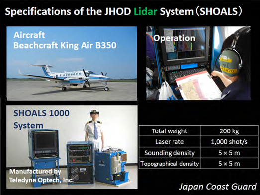
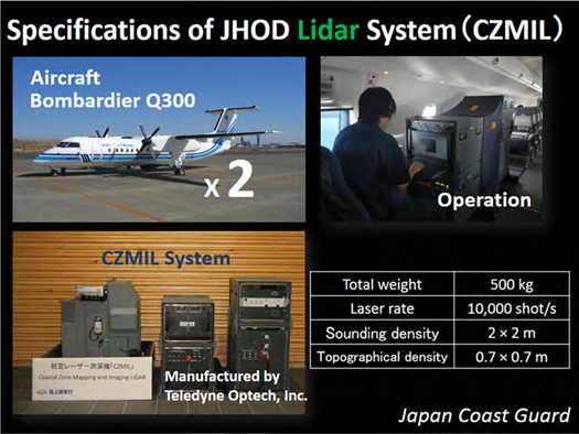
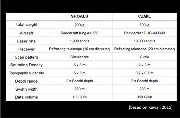
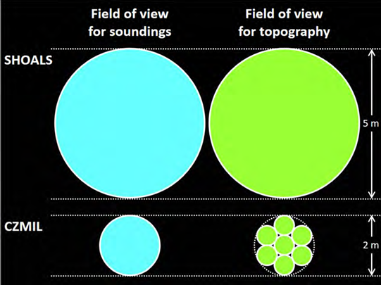
We have been operating two lidar systems manufactured by Teledyne Optech Inc.: Scanning Hydrographic Operational Airborne Laser Survey (SHOALS) 1000 (Figure 1) since 2003, and Coastal Zone Mapping and Imaging Lidar (CZMIL) (Figure 2) since 2013. Table 1 lists the main specifications of SHOALS and CZMIL. SHOALS scans the seafloor in a circular arc pattern, whereas CZMIL uses a full circular pattern at a measurement frequency 10 times higher (Kawai, 2015). CZMIL’s field of view for each laser shot is narrower, especially for land topography and shallow water (shallower than 15–20 m) (Figure 3). Thus, CZMIL has improved the point density of deep-water bathymetry 6-fold and that of shallow-water bathymetry and land topogra-phy 51-fold (Figure 3). Figure 4 depicts the common principles of lidar operation for the both systems.
The following sections give an overview some examples of the JHOD’s ALB survey. All of the figures shown in the following sections are preliminary results after simple noise reduction processing.
3. Supporting the Reconstruction of Disaster Areas Affected by the “2011 off the Pacific coast of Tohoku Earthquake”
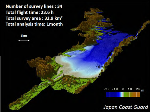
On 11 March, 2011, the northeastern part of the main island of Japan (Tohoku region), was struck by a megathrust earthquake called “the 2011 off the Pacific coast of Tohoku Earthquake”. This was the largest in Japan’s observation history, as well as the fourth-largest in the world since 1900, according to the records of the United States Geological Survey. In response, JHOD conducted ALB immediately and extensively to help remove obstacles in affected harbors to facilitate the transport of relief supplies to the disaster areas. Figure 5 shows part of the survey data from Miyako Bay obtained by SHOALS. Because this area is surrounded by mountains around 600 m high, aircraft cannot maintain an adequate survey line under normal operation conditions with an imposed bank restriction. For reliable reception of GNSS signals in a survey flight, the aircraft is allowed to turn with a bank angle within 20°, which is shallower than the constraint of the aircraft’s turning performance. Although it increas es risk of failure for the lidar system, we eased the bank restriction in this survey flight. Positioning accuracy was later verified to be 0.1 m or less, which is sufficient for a hydrographic survey. In the Tohoku region, laser penetration is usually shallow due to the abundance of plankton in the water. In addition, the inflow of turbid river water could decrease the transparency of the water in the bay. After the disaster, it was a concern that suspended material and spilled oil carried from the devastated coast into the bay could prevent laser penetration. Fortunately, the water depth was measured down to as deep as 15 m in most of the survey area, so that we obtained seamless topography on land and the seabed, including the destroyed breakwaters.
One possible factor for this result could be the small inflow of river water into the bay; this area had had no rain for two weeks before the survey flight (Ono and Shibata, 2012). The bathymetric and topographic data were used for revising the nautical charts, reconstruction planning of the destroyed harbors, tsunami simulations, and coastal erosion control.
4. Security for the Venue of the G7 Ise-Shima Summit 2016
Japan hosted the G7 Ise-Shima Summit in Mie Prefecture, central Japan, on 26 and 27 May, 2016. The Ise-Shima area is a national park that boasts the beautiful terrain of the Ria Coast on the Pacific Ocean. As part of the safety measures for the summit, a JCG fleet secured the waters around the venue. We provided the Coast Guard offices and patrol vessels with information, such as special nautical charts tailored to fit the needs of the patrols on the waters. We conducted ALB and multibeam echosounding using several survey vessels belonging to the main JHOD office and the regional headquarters. Figure 6 shows part of the survey results, at Ago Bay. Because the water transparency is excellent in this area, ALB complements the lack of multibeam survey data where a number of small islands, inlets, reefs, and other topographic features prevent survey boats from safe, efficient survey work.
The survey results were processed into an electronic navigational chart, which was viewable on tablets. The chart enhanced the patrol capability of the JCG fleet, including a small boat that cannot carry an Electronic Chart Display and Information System. JHOD provided the coastal municipalities with the survey results to help with their coastal zone management.
5. Nishinoshima Volcano
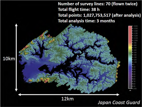
Nishinoshima is a volcanic island located about 1,000 km south of Tokyo. Between 2013 and 2015, intense volcanic activity occurred and a lava flow extended over the island. JHOD conducted a coordinated survey of ALB and multibeam echosounding in October to November 2016. The survey conditions were difficult for the aircraft, because the survey area was about 1,000 km from the air base in Tokyo, and there were no alternative airfields to divert to.
This survey provided the first quantitative topographic information about the shallow-water area around the volcano (Figure 7). ALB clearly captured the topography of the consolidated lava flow that had been already sighted in aerial photographs before the eruption from 1973 to 1974 (Figure 7, white rectangles) (Ono et al., 2017). CZMIL managed to acquire seamless bathymetric and topographic data. Despite the persistent presence of discolored water accompanying the volcanic activity near the coastline around Nishinoshima, CZMIL penetrated the water deeper than expected. The CZMIL data, combined with the multibeam data from a survey vessel and an unmanned survey boat, were used for charting. These fine seamless bathymetric and topographic data provide important clues to the evolution of Nishinoshima Volcano.
After one and a half years of dormancy, Nishinoshima Volcano has been erupting again since April 2017. Further resurveys after the eruption has ceased will quantify the topographic deformation, which may reveal the full picture of the ongoing volcanic activities.
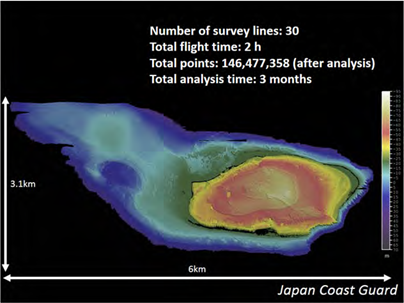
6. Hateruma Island
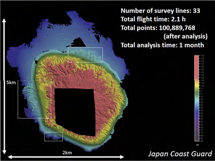
This section presents one of the best examples of our 14-year ALB operation. Figure 8 shows a bathymetric map of Hateruma Island in Okinawa, the southwestern-most prefecture in Japan. This survey area is characterized by high water transparency and clustered coral reefs, as commonly found in the subtropics. It is dotted with sunken rocks and wash rocks due to the development of coral reefs. In such an area, shipboard echosounding carries a high risk of grounding. We chose ALB to survey the broad area around the island efficiently.
CZMIL’s high resolution captured the complex terrain of coral features clearly over a wide area. Figure 9 shows the lagoon-like topography of the northwest offing of Hateruma Island. The detailed distribution of coral reefs is shown in Figure 10.
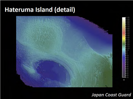
Figure 9: Enlargement of the chart in Fig. 8, showing the northwest offing of Hateruma Island. Lagoon-like topography is clearly reproduced. 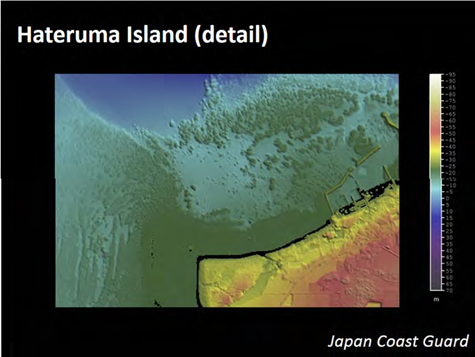
Figure 10: Enlargement of the chart in Figure 8, showing the area off the Hateruma fishing port. The detailed distribution of coral reefs is visible
CZMIL measured water depth down to around 50 m, which is the performance limit of the device. Seamless topography from land to seafloor was reproduced, except in some parts of the surf zone, where whitecaps prevented laser penetration. The broad coverage of the ALB data in this survey area was attributed to the high water transparency of around 30 m and the high reflection intensity of the seabed mainly formed from coral features.
7. Conclusion
ALB is much more than just for nautical charts. In connection with, or sometimes apart from charting, the JHOD has conducted ALB surveys to accomplish a variety of missions, such as disaster response, surveillance for security, and volcanological research.
The applications described here used the advantages of ALB of broad coverage, high resolution, and rapidity in shallow-water surveys. ALB’s seamless acquisition of bathymetric and topographic data is extremely effective; no other technique can achieve greater efficiency in surveying reefs, very shallow areas, or intertidal zones. However, the availability of ALB is susceptible to oceanic and weather conditions such as strong winds, waves, and water transparency. Combining ALB and shipboard surveys, primarily multibeam echosounding, produces a good balance of performance, efficiency, and cost. Keeping pace with advances in survey technology, we will strive for further efficient charting and mapping of shallow waters.
8. References
Kawai, K. (2015) Overview of the new LIDAR “CZMIL”, Report of Hydrographic and Oceano- graphic Researches, 52, 27-32. (in Japanese, with English abstract)
Ono, T. and H. Shibata (2012) Working with airborne LIDAR bathymeter system in Tohoku region, Report of Hydrographic and Oceanographic Researches, 49, 118-129. (in Japanese, with English abstract)
Ono, T, K. Nogami, I. Sato, T. Morishita, I. Fukuyama, S. Yosioka, K. Nakamura, and H. Yamano (2017) Topographic change of the sea floor after the 2013-2015 eruption of Nishinoshima, proceedings of JpGU-AGU Joint Meeting 2017, SVC47-P08. (in Japanese, with English abstract).