
Abstract
By K. Miller 1 , A. Armstrong 2 , R. Furness 3, A. Greenland 4 , G. Johnston 5, R. Nairn 6, N. Roscher 7, N. Seube 8, S. Syawie 9 and L. Tsoulos 10
- The University of the West Indies, Trinidad and Tobago. keith.miller@sta.uwi.edu
- NOAA/University of New Hampshire Joint Hydrographic Center, USA. andy.armstrong@noaa.gov
- IIC Technologies Pty. Ltd., Australia. rfurness@ozemail.com.au
- New Zealand Hydrographic Authority, New Zealand. agreenland@linz.govt.nz
- Venture Geomatics Ltd. UK, g.johnston@venture-geomatics.com
- Rod Nairn & Associates Pty Ltd Australia. rnairn797@hotmail.com
- Directorate of Hydrography and Navigation, Brazil. nickolas.roscher@dhn.mar.mil.br
- Interdisciplinary Centre for the Development of Ocean Mapping, Canada. nicolas.seube@cidco.ca
- Association of Indonesian Marine Survey Contractors (AKSLI). sobri.syawie@pageo.co.id
- National Technical University of Athens, Greece. lysandro@central.ntua.gr
1. Introduction
Hydrography and nautical cartography can be used for many disparate purposes, but irrespective of their application, the disciplines of hydrography and nautical cartography are necessarily international. For navigational purposes, watch-keeping officers are required to operate within international protocols, using nautical charts that comply with international standards. There must, then, be a requirement for hydrographers and cartographers responsible for producing those charts to work within a framework of international standards. Similarly, hydrographers and cartographers working in the offshore and construction sectors are expected to adopt professional practices compliant with standards that lead to competent operations and, ultimately, security of the environment. Trinder (2008) offers a partial review of how competency standards are adopted by professional bodies associated with surveying. These typically relate to a professional body within a particular state, sometimes based on legislation, and some states award licenses for surveyors to practice within that state while others have an international membership component. Membership status, or a regional license, is obtained through education, by successful completion of an accredited program of study, together with supervised experience. The individual then operates based on recognized professional status and experience accumulated. As individuals, members of these professional bodies are required to maintain ethical practices and undertake continuous professional development to maintain their membership status. Kapoor (1980) identified the need for international standards of competence for hydrographic surveyors in both the governmental and industrial sectors and reported on the origins of such standards that were first considered in 1972 with the first standards released in 1978. Standards for nautical cartographers were introduced in 2003. Both standards are highly detailed in comparison with those typically adopted by professional bodies and are endorsed by the International Federation of Surveyors (FIG), the International Hydrographic Organization (IHO) and the International Cartographic Association
(ICA); they have undergone major revisions through time with details to 2002 reported by Astermo and Gorziglia (2002). Overarching professional authorities of the FIG, the IHO and the ICA represent agencies and professional institutions within their respective membership at an international level rather than individuals, who are able to claim within their professional portfolio that they have completed a FIG/IHO/ICA recognized program. There is, however, an allowance for recognition through schemes whereby a professional body adopts the FIG/IHO/ICA competencies and makes enhancement through requirements for professional practice that then offers membership status. Nairn and Randhawa (2010) explain how such a scheme operates within the Surveying and Spatial Sciences Institute (SSSI) in Australia and the New Zealand Institute of Surveyors (NZIS). A comparable scheme exists through the Association of Canada Lands Surveyors (ACLS). Competencies provided within the standards are common to both program recognition and to schemes and form the basis for this paper.
The standards are drafted by the International Board on Standards of Competence for Hydrographic Surveyors and Nautical Cartographers (the Board) which, following rigorous assessment, awards recognition to programs that meet the relevant Standard. The Board comprises ten representatives, four nominated by the IHO, four by the FIG and two by the ICA. The IHO provides the Secretary and secretarial support to the Board. Members come from a mixture of academic institutions, government agencies and industry. At its annual meeting the Board consolidates its prior preliminary reviews of programs submitted for recognition. A program submission is normally supported by a presentation to the full Board by the submitting organization after which the Board makes its decision concerning the award of recognition. A program may be awarded recognition, conditionally recognized subject to an intersessional resubmission that addresses deficiencies, or, not recognized, in which case reasons are given and the applicants may return with a suitably modified submission the following year.
Maintaining the standards in line with changes in technology, practice and increasing diversity of the disciplines covered is an ongoing responsibility of the Board. Furthermore, developments in education also need to be considered. Given the significant changes in both of these areas that have taken place in the last decade, a decision was made by the Board to revisit the style in which the standards are presented. Over the last five years the Board has fully revised the standards in terms of their structure, coverage, content and description of competencies. Principles underpinning the new standards are presented here.
2. Trends in program recognition
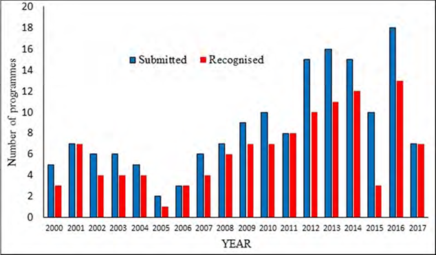
Programs submitted against the standards are considered by the Board each year through a report prepared by the submitting institution demonstrating that their offering is aligned; representatives are also strongly recommended to make a presentation to the Board. Guidelines to assist in the preparation of submissions developed by the Board are published by the IHO (2017a). Successful programs are awarded recognition for a period of six years; prior to 2007 it was ten years: in view of rapidly changing advances in technology ten years proved to be too long a period. Figure 1 shows that the number of programs being submitted for recognition has risen considerably since 2011; this is partly due to the reduction in the recognition period and partly due to new programs that are being put forward. There was a reduction of submissions in 2017 when a number of institutions requested a one year extension to their programs for hydrographic surveyors in order that they could revise programs in alignment with the new standards that came into force from 2017 for submissions.
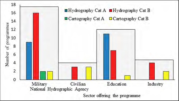
Standards for both hydrographic surveyors and nautical cartographers are provided at Category “A” and Category “B” levels. Kapoor (1980) explained why these terms were adopted rather than variants such as professional for Category “A” and technical for Category “B”. There are currently 60 recognized programs spread across 30 countries: the division between hydrography and cartography at the different levels and between sectors is provided in Figure 2. At a national level, the hydrographic office responsible for surveys and charting may come under military or civilian authority and this distinction is made. Education covers establishments such as universities and colleges where teaching towards qualification is the primary business. Programs offered by the industrial sector are either delivered commercially to fee paying students or internally for staff development within the organization. Category “A” programs in hydrographic surveying and nautical cartography are separated between national hydrographic agencies and educational institutions. All sectors run Category “B” programs in both disciplines, but more are offered in hydrographic surveying by the hydrographic agencies than in any other sector.
3. Structure of the standards
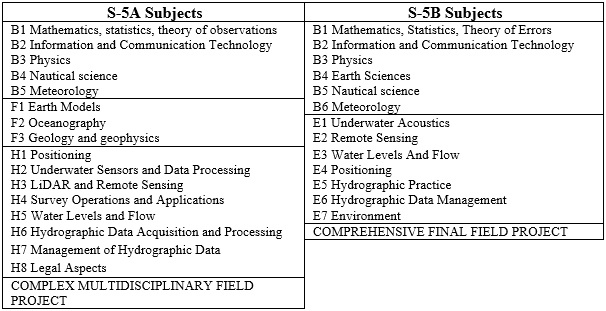
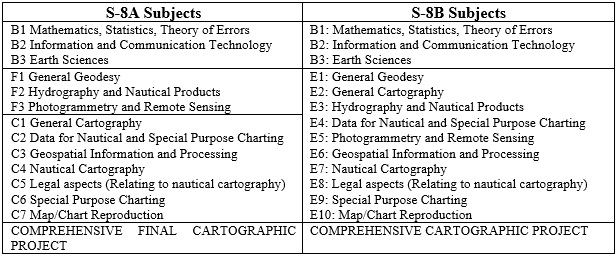
Until the recent revision of the standards, the Category “A” level was provided as an addition to the Category “B” requirements with Standard S-5 representing hydrographic surveying and S-8 nautical cartography. Under the use of modern technologies and associated quality control processes, the roles and responsibilities of those charged with managing the survey and cartographic operations have now become sufficiently differentiated from those conducting the survey and chart production to warrant separation of the standards. While the Category “A” requirements still include equipment operation, the required skill set expects much more in terms of the assessment and management of data acquired. On this basis, the suite of standards was separated into:
- S-5A Standards of Competence for Category “A” Hydrographic Surveyors (IHO, 2017b)
- S-8A Standards of Competence for Category “A” Nautical Cartographers (IHO, 2017c)
- S-5B Standards of Competence for Category “B” Hydrographic Surveyors (IHO, 2017d)
- S-8B Standards of Competence for Category “B” Nautical Cartographers (IHO, 2017e)
In addition to separation of the standards, options that were previously defined have been removed. An article that appears on the National Oceanographic and Atmospheric Administration (NOAA, 2014) website written to celebrate World Hydrography Day in 2014 with the theme “Hydrography – Much More Than Just Nautical Charts“, demonstrates how the disciplines of hydrographic surveying and nautical cartography have become more diverse in their applications than can be satisfactorily expressed in a short list of options. It is also considered desirable for students and for industry and government to have a range of programs offered globally, each with a unique flavor, rather than it is to have a set of clone programs offered in different locations. The minimum standards must ensure coverage of core components expected of any hydrographic surveyor or nautical cartographer while allowing flexibility to specialize in alignment with the aim of a particular program. Options that were included to allow specializations to be covered by the standards are no longer specified within the standards with some key components being incorporated into the body of the new standards.
Initially the disciplines of hydrographic surveying and nautical cartography are organized into the subject headings given in Tables 1 and 2, respectively. While some of the titles are the same in the different standards, the expectations are aligned differently and set at different levels. The aim of the standards is to describe the core requirements, but this is dependent on the academic background of the entering matriculants. Exemptions on the basis of prior learning may then be permissible. The standards are structured with subject groups identified as:
- Basic (B) and Essential (E) at Category “B” level; and,
- Basic (B), Foundation (F), and Hydrographic Science (H) or Cartographic Science (C) at Category “A” level;
with exemptions being allowed in the Basic and
Foundation subjects. The latter only exist at Category “A” level, which might be offered for example as a Master’s degree program. Then, in S-5A or S-8A, a student entering with a first degree in Land Surveying, Ocean Science, Geology, Cartography or Geographic Information Science could be exempt from the relevant Foundation subject provided evidence of prior coverage at the required level can be validated. Essentials and specialist science subjects in hydrographic surveying and nautical cartography are then grouped into relevant theoretical, operational and managerial headings.
4. Expressing competencies
Constructive alignment as presented by Biggs (1996) is a development in the guidelines for education that is now accepted practice in tertiary education: it is a component of the Bologna Process (European Commission/EACEA/ Eurydice, 2015) that standardizes educational practices across Europe. The intention is to deliver material constructively in a way that the learner thinks and to align the assessment accordingly through a set of learning outcomes: implementation is documented by Biggs and Tang (2011). The concept of alignment hinges on assessment against the desired outcomes of a course with appropriate verbs used to indicate the expected level of learning. It is not possible to assess each small component of a course independently and to determine that a student has grasped concepts that are spread across the course; the assessment must be set with a broad scope. Outcomes must therefore be generic. Williamson (2014) suggests that between 4 and 6 is a reasonable number for a program module and a typical university student would take about 6 modules per semester. On this basis, a student might spend 12 weeks of study towards about 30 learning outcomes at first degree or at master’s level. Outcomes must be well defined in terms of scope and measurable through assessment, although not all need to be assessed directly; this is considered in relation to the standards within the discussion.
The standards intend to express competencies necessary to function in a particular role. Kennedy, Hyland and Ryan (2006) consider the difference between competencies and learning outcomes, concluding that the term ‘learning outcomes’ is better defined in educational literature. Learning outcomes can be written to cover a range of skills based on knowledge acquired, understanding or ability to perform some task, which is exactly how a set of competencies can be described. However, the term ‘competencies’ is much broader in its scope; for example, at a technical level there could be a binary response to completion of some simple operation. As the standards intend to address programs of education at tertiary level, it is appropriate to write standards of competence in terms of learning outcomes. Drafting of the standards in this format was informed by documentation published by those involved in education for university curriculum design such as Biggs and Tang (2011), Williamson (2014) and Kennedy, Hyland and Ryan (2006). However, due to the generic nature of learning outcomes it was also found necessary to offer a context and to indicate required coverage, which is achieved by providing a list of content. Within the standards, the subjects identified in Tables 1 and 2 are further divided into topics and topics into elements with one or more learning outcomes associated with each element. Content may be shared across elements. The example provided in Table 3 from S-5A also indicates the intended scope of applications for the standards in relation to hydrographic surveying.
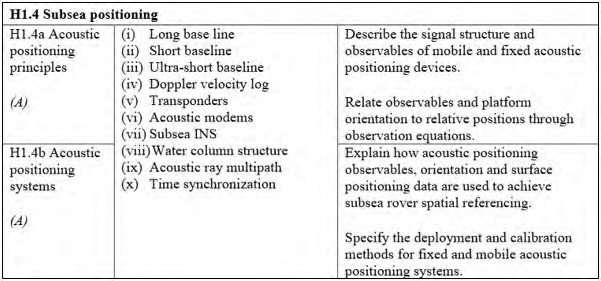
Bloom’s taxonomy (Bloom, B.S. (Ed.) 1984, Anderson, L.W. et al. 2001) has been applied to describe each element of the standards and the associated verbs used within the learning outcomes are an indication of the depth of learning. Verbs such as “define, identify, describe, explain, differentiate, predict” are associated with knowledge and comprehension, while “apply, use, calculate, solve, classify, analyze” require a deeper understandding of principles and are associated with application and analysis. Finally, to demonstrate deep knowledge required for synthesis and evaluation, students should be assessed on their ability to “evaluate, select, design, specify, plan, create”. Learning outcomes prescribed within the standards follow these guidelines; however, it was also considered necessary to introduce further indication of level expected and this is achieved through quantifiers: Basic (B); Intermediate (I); or, Advanced (A) that are given within the element as shown in Table 3. In this example, the verbs used in the learning outcomes (Establish, Specify and Evaluate) require deep knowledge and the level is Advanced. Another example provided in Table 4 uses verbs associated with learning levels of knowledge and comprehension, but the elements are also considered as Advanced to reflect the complexity of the subject. The two learning outcomes in element H1.4a (Table 4) draw on content from the Basic subject in Physics (B3) and on Vessel and Sensor Reference Frames (contained in H1) requiring application of principles learned in these elements, which have levels of Basic and Advanced respectively. While the verbs “describe” and “relate” used in H1.4a imply comprehension under Bloom, the student is expected to be able to offer a description and a relationship at a detailed (Advanced) level aligned with knowledge of concepts developed previously.
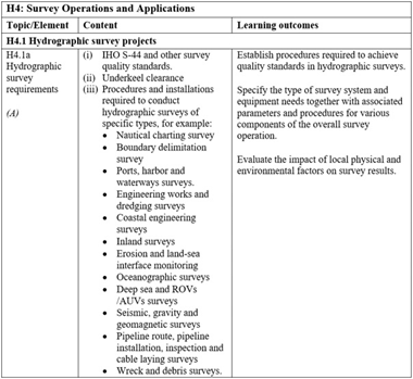
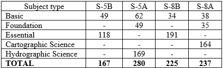
Table 5 gives the number of learning outcomes in each of the standards, broken down into subjects. There are more requirements in the Basic and Foundation subjects in the hydrographic standards; this is because there is a greater likelihood of students entering these programs possessing some relevant background with nautical cartography being less dependent on a material that might have been previously covered. There is little difference in the number of outcomes prescribed in the two nautical cartography programs, but the level of expectation of those outcomes is significantly different.
Minimum durations for programs are set at 24 weeks for Category “B” and 40 weeks for Category “A”. It is anticipated that students on an intensive program of such duration will spend in the region of 50 to 60 hours per week on their prescribed studies and personal study. Any Category “B” program in nautical cartography will be particularly intensive in terms of learning expectations over the minimum period. It should be noted that the program durations are set at a minimum, many programs submitted against the standards are longer. Here, the reader is reminded that the standards are minimum standards.
6. Final project
Each of the standards specifies the expectations for a comprehensive final project of 4 weeks in duration, which is independent of any practical work undertaken during previous program modules. Dunlap (2005) describes the advantages of problem-based learning in this style as a transition between education and the working environment. Project work in groups allows students to practice the knowledge acquired through program modules, operate in a team environment and reflect on their experiences. Specifications for project work given to students working towards a program that is recognized against the FIG/IHO/ICA standards expects the program participants to be involved in planning, execution and reporting on the project that is suited to the level of the standard. The objectives of the project are aligned with aspects of a “capstone project” that is common to engineering disciplines in the USA. As the accreditor for Engineering education in the USA, the Accrediting Board for Engineering and Technology (ABET) introduced a set of five engineering criteria for engineering programs, these are documented by Lattuca, Terenzini and Volkwein (2006). Criterion 3 relates to program outcomes and assessment requiring programs to demonstrate that students can apply knowledge gained in the program, design and conduct tests, function in a team, solve problems and communicate. Criterion 4 is aligned with preparing students for the professional environment through the application of knowledge gained in previous courses together with elements of professional conduct such as ethics and health and safety. A difficulty that is encountered with this type of team project is assessment of the individual against the prescribed learning outcomes. In conducting a review of the use of capstone project schemes offered by universities in the USA against ABET criteria 3 and 4, McKenzie, Trevisian, Davis and Beyerlein (2004) offer a summary of assessment techniques. They found that multiple assessments of different styles were generally applied throughout the project. While those associated with criterion 3 could be measured, it was more difficult to deal with criterion 4 with only about half of the requirements being considered measurable.
Most of the learning outcomes in the FIG/IHO/ ICA standards are aligned with criterion 3, only the measurable component of application of knowledge from criterion 4 is relevant. Professional elements of the ABET criterion 4 relate to requirements for individual membership of professional bodies, which is beyond the scope of the standards.
The final project specified in each of the standards is a learning exercise, it is aligned with some of the criteria set down by ABET and project work should be led by the students. By the time they reach this stage, the knowledge in each of the component parts should have been acquired, this is the opportunity for them to consolidate the information and skills gained within the prior program modules. However, they are still being assessed and relevant learning outcomes specified in the standards are applicable.
6. Quality assurance of programs
National councils such as the Quality Assurance Agency for Higher Education (QAA, 2017, part B) in the United Kingdom and the Tertiary Education Quality and Standards Agency (TEQSA, 2017) in Australia, lay down standards for academic programs that are designed to assure quality of the student experience. Aspects such as currency of material, standard of the learning environment and student engagement in the learning process are conducive to the acquisition of knowledge and skills that are relevant to potential student destinations. The S-5A, S-8A, S-5B and S-8B standards detail the minimum requirements of curricula and currency of content is maintained through updates to the standards. However, the Board also strives to ensure that further quality assurance measures are in place within organizations offering recognized programs. Guidelines for submissions against the standards (IHO, 2017a) detail expectations of internal quality assurance mechanisms that are expected to be in place.
An appropriate level of attainment prior to entry into any program of education is fundamental to the student experience and requirements for entry must be specific, together with details of any prior qualifications that may lead to exemptions from Basic and Foundation subjects. For host institutions in the commercial and academic sectors it is common to accept candidates who are changing career and may not have studied for some years. Such candidates may be required to undertake preentry refresher courses and a number of potentially relevant options exist online. It is important that students are prepared to undertake a program in terms of both their level of prior knowledge and state of preparedness to study for assessment. Individual students must then be monitored as they progress through the modules of the program. As indicated when discussing learning outcome H1.4a shown in Table 4, a program must be structured for progression with the later components having a dependency on prior material. In order to progress, each student must have demonstrated an understanding of learning outcomes within the earlier modules and work undertaken in the final project requires an understanding of all previous material. Means of assessment must be in place at each stage to ensure that students have grasped the concepts and practical skills at the level necessary for progression with an allowance for remedial action in case they have not. The required level is indicated by the verb used in the learning outcome and level associated with the element.
Resources must be available for delivery in all respects including specialist staff for delivery of the various components, teaching space including facilities for practical work, study space for students with access to reference material and specialist software. In addition to scheduled delivery times the students are expected to undertake guided study both individually and in group activities, the necessary space and access must be provided.
Institutions are required to have in place an internal review process for each program with the review considering feedback from stakeholders. The review considers aspects of the program such as content, scheduling, delivery and assessment with a view to improvement and update. QAA (2017, part B) recommends that any program should undergo a comprehensive internal review every 3-5 years, more frequently for new programs. An important part of the review is student feedback on their experience, which must be obtained from each cohort on exit for immediate consideration. Urgent issues raised by the student body can be dealt with for the next delivery. The institution must have in place a formal mechanism for obtaining documented feedback from students on program completion together with a structured approach for immediate review and reaction to responses.
To complement documentation submitted towards recognition and annual reports received for recognized programs, the Board also has a mechanism for undertaking on site visits to host organizations. A visit typically involves 2 or 3 Board members reviewing documentation submitted by the organization in advance then visiting the location of program delivery to meet with staff and stakeholders and review resources. Details of the purpose and procedures are provided in IHO (2017a).
7. Discussion
Competencies that are applicable internationally for hydrographic surveyors and nautical cartographers are now provided in a form that is accepted in educational practice. During development of the standards, a review process took advantage of professional events for presentation of progress and feedback. The structure and style of presenting standards through learning outcomes was readily accepted by members of the various sectors offering programs and by those in a position to employ graduates from the programs. Endorsement of the standards is given by the FIG, the IHO and the ICA; in the case of the IHO the approval depends on its 87 Member States. Constructive comments were all considered in detail and many led to the drafts being changed prior to adoption.
The standards express competencies in terms of learning outcomes and guidelines that accompany the standards lay down expectations in terms of quality assurance processes that must be in place together with requirements for submission against the standards. Organizations submitting programs are expected to provide details of teaching schemes, practical work, assessment specifications and assessment criteria for theoretical and practical elements. This information offers evidence that learning outcomes are being met at the level prescribed in the standards, that competencies are being gained through knowledge, that this is underpinned with experience and that practical skills are acquired. The standards are international and Miller (2010) considers the cultural differences in learning that will lead to different styles of delivery. The standards do not specify delivery mechanisms, but there is an expectation for sufficient practical content. Technology is available that will allow some of the competencies to be acquired remotely and some programs that incorporate e-leaning components are currently recognized at Category “B” level in hydrography.
Specifications within the cguidelines require that submitting institutions specify the program modules in which each element of the standard is assessed. In a well-constructed program module the learning outcomes will cover the material holistically, they do not provide a teaching scheme and as such it is not always possible to relate each individual learning outcome from the standards to a particular assessed task or practical exercise. Adam (2008) states that over-prescribed learning outcomes can lead to an assessment based curriculum that inhibits the learning process. The learning outcomes should be more general in their coverage of the material. Therefore, in reviewing submissions towards recognition, it would be difficult to determine whether each and every learning outcome is being assessed within the program. In many instances, learning outcomes from different elements will be merged into one practical task or into one exam question, a one-to-one relationship between learning outcomes and assignment components is not expected and, as such, it would be difficult to identify each individually within the assessment. For example, within S-5A an assessment task might require students to compare methods of seabed classification from optical and acoustic data in some carefully construed environmental situation. This is assessing learning outcomes in elements: H4.3a Explain the techniques available and their limitations for observing, interpreting and classifying differences in seabed characteristics from acoustic sensors and H4.3b Explain the techniques available and their limitations for observing and interpreting differences in seabed and intertidal zone characteristics from optical sensors. However, in constructing their arguments in response, students will be addressing other elements from the standards including H3.1b: Explain how to incorporate information from full wave- form analysis in the production of LiDAR mapping products and the specify element of H2.5a Specify and configure a side scan sonar and a swath echo sounder for backscatter acquisition under varying environmental conditions and for specific application. The configure requirement of this latter learning outcome will require a practical exercise, otherwise these latter two outcomes are being assessed indirectly within the response to the question. There is a requirement within the guidelines for a submission to identify time spent on each element, and it is this information together with the examples of assessment that is used by the Board to review the program against the standards. This informs on the scope of coverage in alignment with that of the learning outcomes and that the level conforms to the specifications in the standards.
The extract from S-5A on acoustic positioning provided in Table 4 demonstrates how learning outcomes are used to cover theoretical components as well as connecting that theory to applications and associated practical skills. Element H1.4a addresses the principles of acoustic positioning and draws on subjects covered at Basic and Foundation level. The first learning outcome in H1.4b then extends these principles to an application in positioning of a subsea rover and the second learning outcome requires the provision of specifications for an associated practical task. In order to respond to this requirement the student must have a full understanding of relevant methods available at a level where comparison can be made for justification of specifications. By comparison, a learning outcome at the Category “B” level in hydrographic surveying requires the student to be able to Describe the deployment, calibration, signal structure and performance of acoustic positioning devices and they must also be able to Deploy and recover oceanographic and hydrographic equipment, both at Basic level. Under these two learning outcomes the Category “B” student must demonstrate an ability to perform a practical task with an awareness for purpose and procedure. While this is relevant to acoustic positioning there is no specific requirement in the standards for students to deploy and use acoustic positioning equipment. It would be expected that a programme offering particular aspects of industrial hydrography would have access to such equipment, but this is considered beyond the resources that may be available to programs in other areas such as charting. Learning outcomes associated with equipment that is widely used across all applications are more specific in requirements for deployment, operation and detailing system specifications. All programs are expected to provide access to multibeam echo sounding equipment, the associated learning outcomes are written accordingly and the inclusion of multibeam echo sounders in the final projects in hydrographic surveying is a requirement.
In considering the number of learning out-comes in the standards as given in Table 5, it was noted that the expectation may be more than is typical of an academic program of the same duration. In providing learning outcomes to function professionally against international requirements, there are a number of learning outcomes within the Basic and Foundation subjects that are essential elements of a program and must be referred to specifically, but which are integrated within the wider scope. For example, many of the seamanship skills in nautical science would be incorporated within practical exercises afloat and in basic training and mobilization tasks that would be undertaken within practical work. These outcomes are included to ensure that the students themselves are actively involved in equipment mobilization and deployment. Some of the learning outcomes associated with these tasks will be delivered and assessed simultaneously in a short time-frame. Similarly, some outcomes within the standards deserve less attention than others. For example, the outcome of element F1.3e in S-5A reads Relate historical surveys to legacy positioning systems. This might be delivered briefly in a class room, afloat on a practical exercise while running survey lines, or in a mathematics class when considering error propagation. Once the students are responsive to the notion that GNSS technologies have not always been available and indicate an awareness of the deficiencies and accuracies associated with techniques of the past then the learning outcome has been covered. There may be no evidence of coverage of this outcome beyond a cross reference to a program module and a very short time allocation is expected.
6. Conclusions
Two new FIG/IHO/ICA standards of competence for hydrographic surveyors are in force, those for nautical cartographers were sent to the IHO Member States for ratification in 2017 for approval1. These replace the previous standards and offer a complete update in terms of structure of the documents and style in which competencies are presented. The drafting process took an intensive five years, included interaction with stakeholders and a full review by IHO member states was undertaken. Standards of Competence for Category “B” Hydrographic Surveyors (S-5B) was released in January 2016 and S-5A in August 2016, both were used for recognition of programs submitted in 2017 with the three programs submitted against S-5A and two against S-5B all being awarded recognition. Guidelines for submitting organizations have also been revised in alignment with the new standards, these provide full details of requirements for submission against the standards. Institutions submitting against the standards are expected to provide evidence that their program is compliant. There is a requirement to identify time spent on each element of the standards and the module in which this is delivered. The standards are not prescriptive in this regard and this is to allow flexibility within the aim of individual programs so that they carry an identity. However, time allocated to competencies that are common across the respective disciplines are expected to be set at an appropriate level with a suitable distribution between practical and theoretical components. The level of learning is evidenced by expectations within the program assessment, which must also demonstrate coverage across the scope of learning outcomes specified within the standards. The guidelines that accompany the standards specify further requirements for program management to ensure that quality assurance mechanisms are in place; these processes are designed to support the learning experience of the student. In addition, minimum time periods without exemptions are set for programs at 24 weeks for Category “B” and 40 weeks for Category “A”, these are considered as absolute with the amount of learning expected within this duration leading to highly intensive programs.
While professional bodies offer membership to individuals who meet academic and professional requirements, the FIG/IHO/ICA standards prescribe a detailed suit of theoretical knowledge and practical skills that reflect the international needs of the workforce in all aspects of hydrographic surveying and nautical cartography. Two professional bodies working at regional and national levels have adopted the standards as meeting competency requirements to practice in a professional capacity. The needs of industry and relevance of recognition against the standards is also apparent in the number of programs seeking recognition, which has increased from an average of 6 per year prior to 2012 to 13 since then.
Looking to the future, the standards have now been updated to reflect and incorporate the new trends, technologies and expectations of the profession. The hydrographic and cartographic professions are likely to have a greater emphasis on regulation, standards and the competencies of the work force placed upon them by a more diverse, demanding and knowledgeable stakeholder community. These four new standards and their associated guidelines aim to provide that foundation.
9. Acknowledgements
The Authors acknowledge, on behalf of the Board, the International Federation of Surveyors (FIG), the International Hydrographic Organization (IHO) and the International Cartographic Organization (ICA) for their ongoing support in all aspects of the Board’s work. The Board also acknowledges representatives from numerous institutions internationally who have contributed to the development of new standards by attending stakeholder meetings, providing feedback on drafts and hosting working group meetings of the Board. To the organizations who submit their programs to the rigors of the standards, the Board acknowledges the wider and mutual interest of all who seek to assure the adoption of best practice internationally for education in the disciplines of hydrographic surveying and nautical cartography.\
10. References
Anderson, L.W., Krathwohl, D.R., Airasian, P.W., Cruikshank, K.A., Mayer, R.E., Pintrich, P.R., Raths, J., Wittrock, M.C. (2001). A Taxonomy for Learning, Teaching, and Assessing: A revision of Bloom’s Taxonomy of Educational Objectives, 352p. New York: Pearson, Allyn & Bacon.
Astermo, S. and Gorziglia, H. (2002). Standards of Competence for Hydrographic Surveyors and for Nautical Cartographers. FIG XXII International Congress, Washington, D.C. USA, April 19-26, 2002, 12p.
Adam, S. (2008). Learning Outcomes Current Developments in Europe: Update on the Issues and Applications of Learning Outcomes Associated with the Bologna Process. Bologna Seminar: Learning outcomes based higher education: the Scottish experience, 21 – 22 February 2008, at Heriot-Watt University, Edinburgh, Scotland. 20p.
Biggs, J. (1996). Teaching Through Constructive Alignment. Higher Education. Vol. 32, No. 3, pp 347-364. Springer.
Biggs, J. and Tang, C. (2011). Teaching for Quality Learning at University (Society for Research into Higher Education), 4th Edition. 480p. Open University Press.
Bloom, B.S. (Ed.). Engelhart, M.D., Furst, E.J., Hill, W.H., Krathwohl, D.R. (1984). Taxonomy of Educational Objectives, Handbook I: The Cognitive Domain, 2nd Edition. 201p. Addison Wesley Publishing Company. Boston, USA.
Dunlap, J.C. (2005). Problem-Based Learning and Self-Efficacy: How a Capstone Course Prepares Students for a Profession. Educational Technology Research and Development, 53(1), pp. 65-85.
European Commission/EACEA/Eurydic (2015). The European Higher Education Area in 2015: Bologna Process Implementation Report. 304p. Luxembourg: Publications Office of the European Union.
IHO (2017a). Guidelines for the Implementation of the Standards of Competence for Hydrographic Surveyors and Nautical Cartographers, Second Edition, Version 2.0.0. The International Hydrographic Organization, Monaco. 31p.
IHO (2017b). Standards of Competence for Category “A” Hydrographic Surveyors, First Edition, Publication S-5A, Version 1.0.1. The International Hydrographic Organization, Monaco. 35p.
IHO (2017c). Standards of Competence for Category “A” Nautical Cartographers, First Edition, Publication S-8A, Version 1.0.0. The International Hydrographic Organization, Monaco.
IHO (2017d). Standards of Competence for Category “B” Hydrographic Surveyors, Publication S-5B, First Edition, Version 1.0.1. The International Hydrographic Organization, Monaco. 25p.
IHO (2017e). Standards of Competence for Category “B” Nautical Cartographers, First Edition, Publication S-8B, Version 1.0.0. The International Hydrographic Organization, Monaco.
Kapoor, D.C. (1980). Standards of Competence for Hydrographic Surveyors. International Hydrographic Review, The International Hydrographic Organization, Monaco, LVII (1), pp. 25-30.
Kennedy, D., Hyland, A. and Ryan, N. (2006). Writing and using learning outcomes: a practical guide, in Froment, E., Kohler, J., Purser, L. and Wilson, L. (Eds), EUA Bologna Handbook, Raabe, Berlin, 30p.
Lattuca, L.R., Terenzini, P.T. and Volkwein J.F. (2006). Engineering Change: A Study of the Impact of EC2000. ABET, Baltimore, USA, 30p.
McKenzie, L.J., Trevisan, M.S., Davis, D.C. and Beyerlein, S.W. (2004). Capstone Design Courses and Assessment: A National Study. Proceedings of the 2004 American Society of Engineering Education Annual Conference and Exhibition. Salt Lake City, Utah, USA. 20-23 June 2004, pp 9.286.1-9.286.18.
Miller, K. (2010). The Influence of Organizational Culture on Tertiary Education: Observations from the West Indies and North Africa. Teaching Matters 2010: Cultures of Learning, University of Tasmania, Australia, 24-25 November 2010. 9p.
Nairn, R. and Randhawa, J. (2010). Competency Certification for Hydrographic Surveyors – The Australasian Experience. FIG Congress 2010, Facing the Challenges – Building the Capacity, Sydney, Australia, 11-16 April 2010. 12p.
NOAA (2014). Hydrography: More than Nautical Charts. Viewed June 2017.
https://www.nauticalcharts.noaa.gov/staff/ news/2014/docs/135572_NOAA_Hydro- epubP7.pdf
QAA (2017). The UK Quality Code for Higher Education. Viewed June 2017.
http://www.qaa.ac.uk/assuring-standards-and- quality/the-quality-code/quality-code-part-b
TEQSA (2017). Higher Education Standards Framework (Threshold Standards) 2015– TEQSA Contextual Overview, Viewed June 2017
Version1.0.http://www.teqsa.gov.au/sites/ default/files/ HESF2015TEQSAContextualOver- view310316_1.pdf
Trinder, J.C. (2008). Competency Standards – A Measure of the Quality of a Workforce. The International Archives of the Photogrammetry, Remote Sensing and Spatial Information Sciences, Vol. XXXVII. Part B6a. Beijing 2008, pp165-167.
Williamson, M. (2014). Good Practice Guide on Writing Aims and Learning Outcomes. The Learning Institute, Queen Mary University of London, Viewed June 2017.
https://capd.qmul.ac.uk/wp-content/ uploads/2014/05/Aims-and-Outcomes- Guide.pdf
Biography
The International Board on Standards of Competence for Hydrographic Surveyors and Nautical Cartographers consists of ten members nominated by the parent organizations of the FIG, the IHO and the ICA. The diverse interests of these bodies brings a wide range of experience and expertise to the table. Board members are regularly employed in various roles within national hydrographic agencies, educational institutions and industry, with many having career paths that extend across these sectors. All are further involved in professional activities within their region and internationally. Their common interest is the support of training and education in hydrographic surveying and nautical cartography for the development of professionals to operate at different levels required within all sectors. The worldwide composition of the Board together with their combined experience of working globally provides the insight to the needs of the disciplines necessary to cover the breadth and depth required of standards of competence that are applicable internationally.
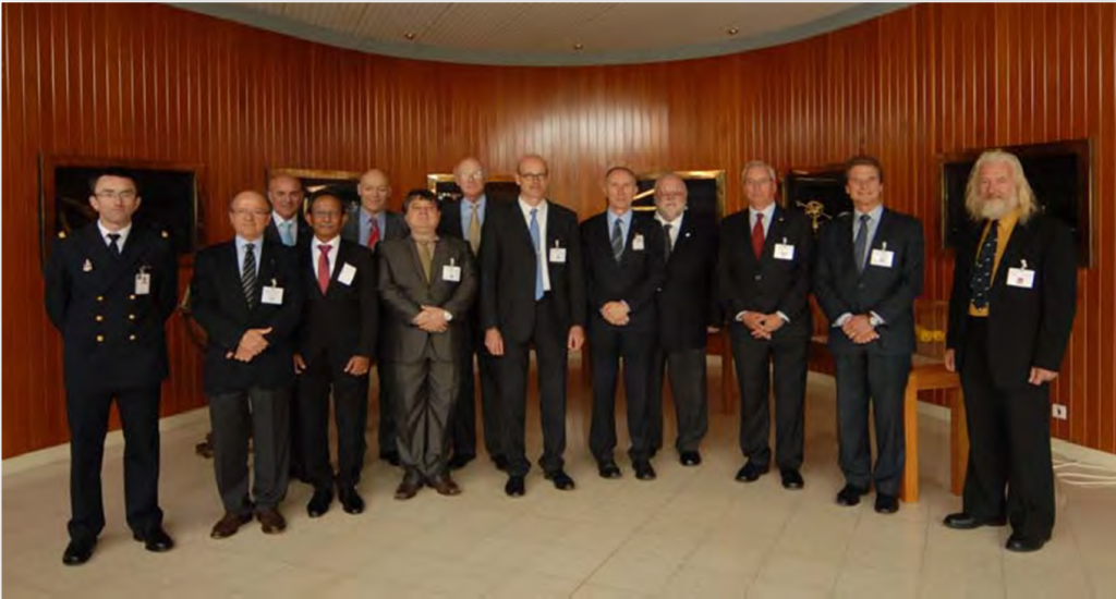
The 2016 annual meeting of the International Board on Standards of Competence for Hydrographic Surveyors and Nautical Cartographers hosted by SHOM in Brest, France. From left to right with Board members identified by their representative organization and territory: Ronan Leroy (SHOM), Lysandros Tsoulos (ICA, Greece), Alberto Costa Neves (IHO, Secretary to the Board), Sobri Syawie (FIG, Indonesia), Gordon Johnston (FIG, UK), Nickolas Roscher (IHO, Brazil), Andy Armstrong (IHO, USA), Nicolas Seube (IHO, Canada), Bruno Frachon (SHOM), Ron Furness (ICA, Australia), Adam Greenland (FIG, New Zealand), Rod Nairn (IHO, Australia), Keith Miller (FIG, Trinidad and Tobago).