

1 Introduction
The global water cycle is of vital importance to life on Earth (Poeter et al., 2020). It is the process by which freshwater continuously moves through the oceans, atmosphere and land. The oceans contain an astonishing 97.5 % of the planet’s water. However, due to its high salinity, this vast quantity of seawater cannot be used directly as freshwater. Natural desalination of seawater is powered by the sun’s energy and happens through evaporation. The water enters the atmosphere as vapour, leaving the salts behind. The water then condenses into clouds, which release rain or snow onto the land, replenishing rivers and lakes with fresh water.
Only 2.5 % of the planet’s water reserves are freshwater. A large proportion of this, 69 %, is locked in glaciers and the polar regions as ice. It is estimated that only 1.2 % of this freshwater is found in rivers, lakes and swamps. So where is the remainder? Around 30 % of the world’s freshwater reserves are stored beneath the Earth’s surface as groundwater. If we ignore the ice, an impressive 99 % of all liquid freshwater is groundwater. Therefore, of all the water on Earth, both seawater and freshwater, only a tiny fraction, less than 1 %, is accessible liquid freshwater. This groundwater flows through aquifers. These are permeable geological layers of sand, gravel or fractured rock. Flowing through these porous materials is considered slow, and finer materials, such as sand, act as natural filters for contaminants.
2 Karst aquifers
Karst landscapes are home to a particular type of aquifer. This type of landscape forms in regions with soluble rock, such as limestone, dolomite and gypsum. One of the defining features of karst is the absence of surface rivers. The dissolution of these rocks allows water to infiltrate into vast underground drainage systems. Around 20 % of the Earth’s total land surface is covered by karst, and karst aquifers supply water to over 25 % of the global population. Karst aquifers can transport large quantities of water very quickly. Unlike other types of aquifers, such as those found in sand and gravel, karst aquifers do not have filtering capacities. Consequently, pollution can spread quickly. This makes the careful study and management of karst aquifers particularly important. The presence of caves can sometimes allow access to these important aquifers.
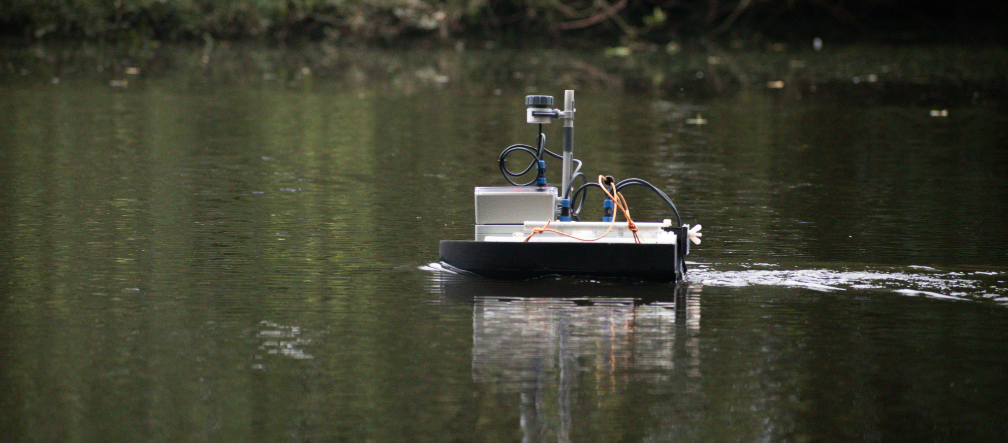
Working in caves is demanding on both people and equipment due to its peculiarities. Therefore, an unsinkable, remote-controlled, portable boat (Fig. 1) was built to map difficult-to-reach underground drainage systems. It is equipped with a single-beam echo sounder (SBES), the Ping2 from Blue Robotics and two Blue Robotics T200 thrusters.
3 No GPS in caves
Ocean survey vessels use GPS to determine their exact location. This data, combined with sonar depth readings, is used to create seafloor maps. However, GPS does not work in caves, so an alternative localisation system must be used. We use a two-way ranging (TWR) real-time location system (RTLS) based on the ultra-wideband (UWB) transceiver module DWM1001C from Qorvo. These devices exchange ultra-short 6.5 GHz (channel 5) pulses and calculate round-trip times to determine distances. Our setup includes six fixed UWB anchors and a UWB tag mounted on the boat. The exact positions of the anchors must be known and are measured using a LiDAR scanner. The distances between the anchors and the tag are recorded several times per second and saved together with the sonar data on an SD card. Back in the office, we use our own software, which uses multilateration and Kalman filtering, to calculate the boat’s position in relation to the fixed anchors. With this setup, we can cover a 100-metre stretch of water. This is significant in caves. The ranging accuracy falls to within 20 cm.
4 A cave-proof construction
Since cave passages can be very narrow, the boat must be small. Measuring just 540 mm × 380 mm × 220 mm and weighing only 7 kg, it can easily be stowed in an airline suitcase or backpack (Fig. 2). It is also built to withstand serious wear and tear when being dragged through caves. After considering materials such as acrylonitrile butadiene styrene (ABS) and polyester plastics for the hull, the rather unusual material Ethylene-vinyl acetate (EVA) foam was chosen. This closed-cell material is lightweight, flexible, chemically resistant, highly durable and easy to work with. It is the same material used in running shoes, for example.
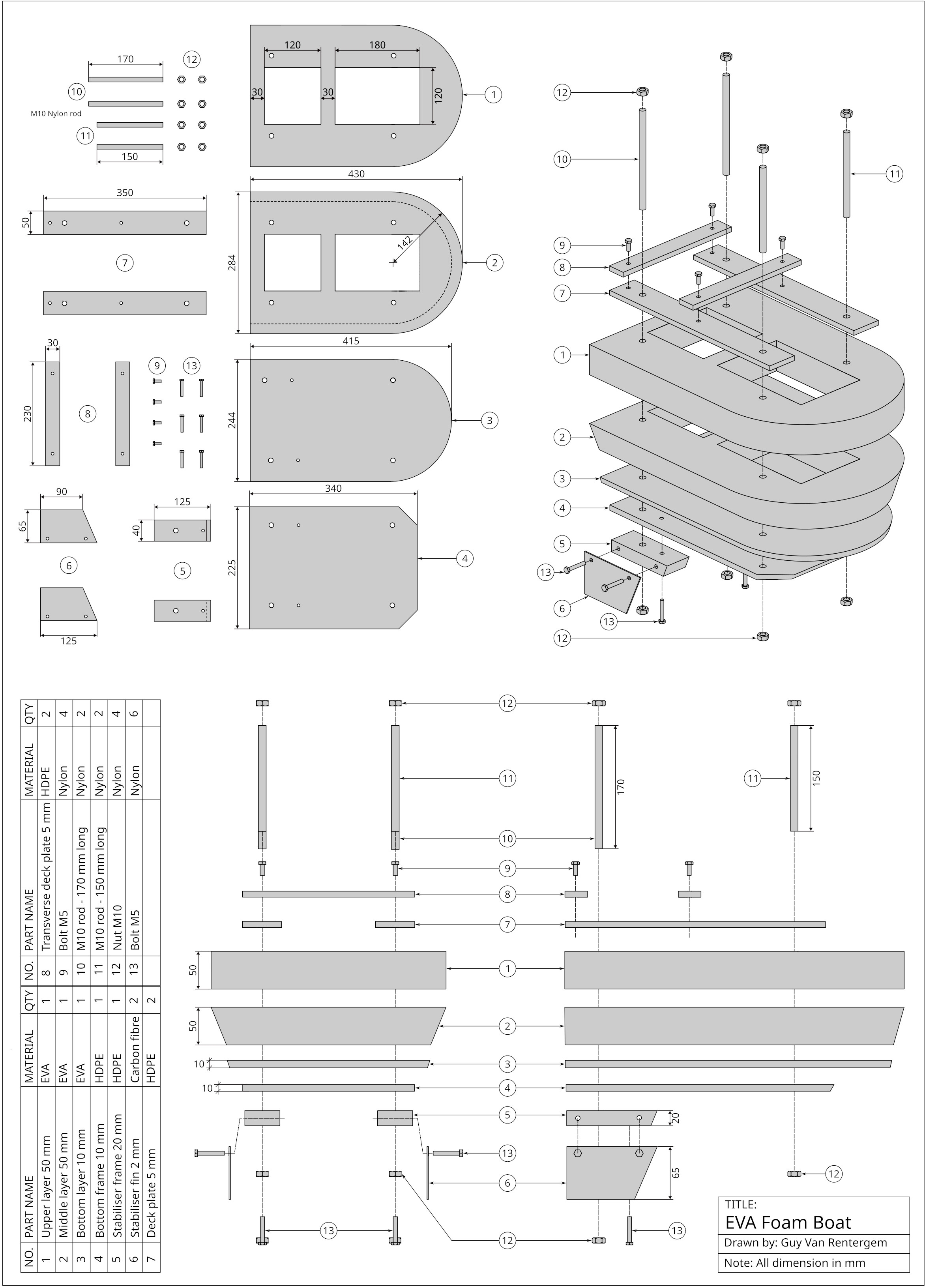
Another basic requirement was that the construction should be simple and use readily available parts, to make assembly and repair in the field easier. The boat’s hull is made of two 50 mm-thick, low-density EVA foam blocks (EVA-45 kg) sandwiched between two 10 mm-thick polyethylene (HDPE) boards. The construction is held together with four 10 mm threaded nylon rods. Two compartments cut into the EVA foam tightly fit two water-resistant boxes that house the batteries and electronics. These enclosures are made of polycarbonate or a similar plastic, with a minimum ingress protection class of IPX5. IPX5 provides protection against water jets. Higher protection ratings, such as IPX7 or IPX8, are unnecessary as this is not a submarine. The boat only needs to be protected against the occasional splash of water, which makes it cheaper to build.
5 Power supply
Batteries are another important component of a boat. Due to their weight and size, they significantly impact the boat’s stability and usability. Nickel-metal hydride (NiMH) batteries are used for power. Although lithium polymer (LiPo) or lithium-ion batteries have a higher energy density and are much lighter, they have one major drawback. They are classified as dangerous goods by airlines due to a potential fire risk, so size, number and packaging limits are imposed. We aren’t as concerned about weight with a boat as we would be with a drone or an RC airplane. In fact, a boat can benefit from some extra weight to go deeper into the water and become more stable. The system has two separate battery circuits. One delivers higher voltage and more power for propulsion, while the other, with lower voltage, powers the sonar and other electronics. This separation prevents brownouts. If all circuits were on the same power rail, a sudden high current demand from the motors could cause a voltage dip and reset of the built-in controllers, which would ruin the measurements.
6 Conclusion
A sturdy and versatile small survey platform that works very well in caves and other extreme or remote locations can be built using simple materials. For example, this mini sonar boat has been deployed in ‘Laguna Caliente’, the hyperacidic (pH 0.5) and hot (55 °C) crater lake of the Poás Volcano in Costa Rica. As we did not want to use our thrusters in such an extreme environment, we equipped the boat with an air propeller mounted on a steerable mast. The boat’s design is highly versatile, and new modules can easily be added to provide additional functionality.
7 Projects
As part of his doctoral research, Romain Deleu surveyed several segments of the subterranean course of the Lesse River in Belgium using a mini-sonar boat, under the supervision of Professor Vincent Hallet at the University of Namur.
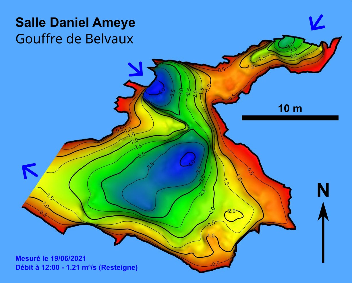
Upon reaching the Grottes de Han limestone massif, the river disappears into a 45-metre-deep siphon known as the Gouffre de Belvaux. To bypass this, a narrow tunnel was excavated by dedicated cavers over eight years. On the other side, the now underground Lesse can be explored for more than 900 metres before it disappears again in an area called Au-delà. A bathymetric survey was conducted in the Salle Daniel Ameyer (Fig. 3). The sonar scan revealed an unknown large sump, which was identified as the main inlet through which the river enters the chamber.
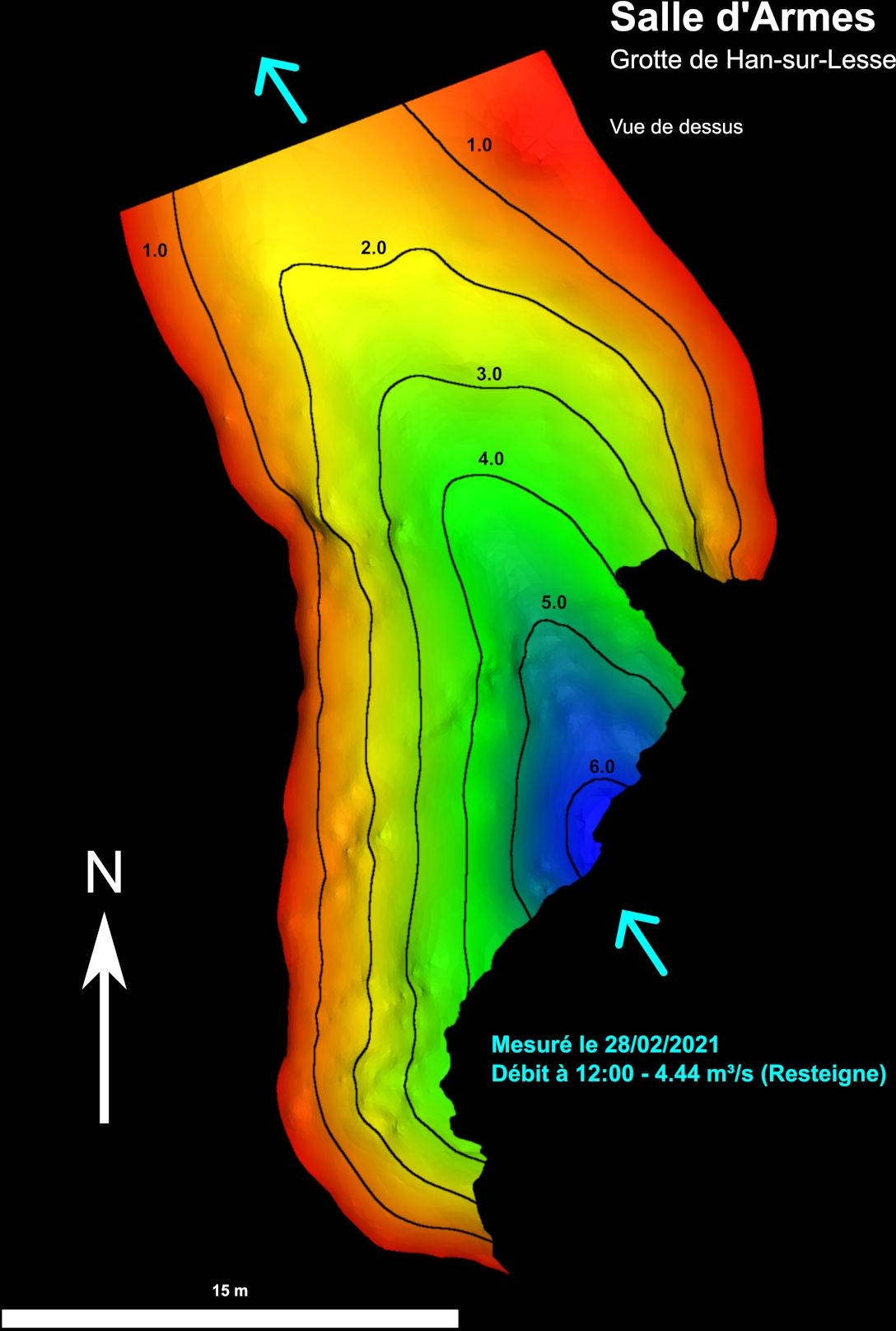
After disappearing into the Au-Delà, the water re-emerges in the Salle d’Armes, a chamber within the famous Grotte de Han tourist cave. The exact location of this siphon was not well known, and it was assumed that the water came from a passageway on the right when looking upstream. This opening can be explored for some distance until it ends in a sump. However, the sonar boat revealed the true position and depth of the siphon (Fig. 4).
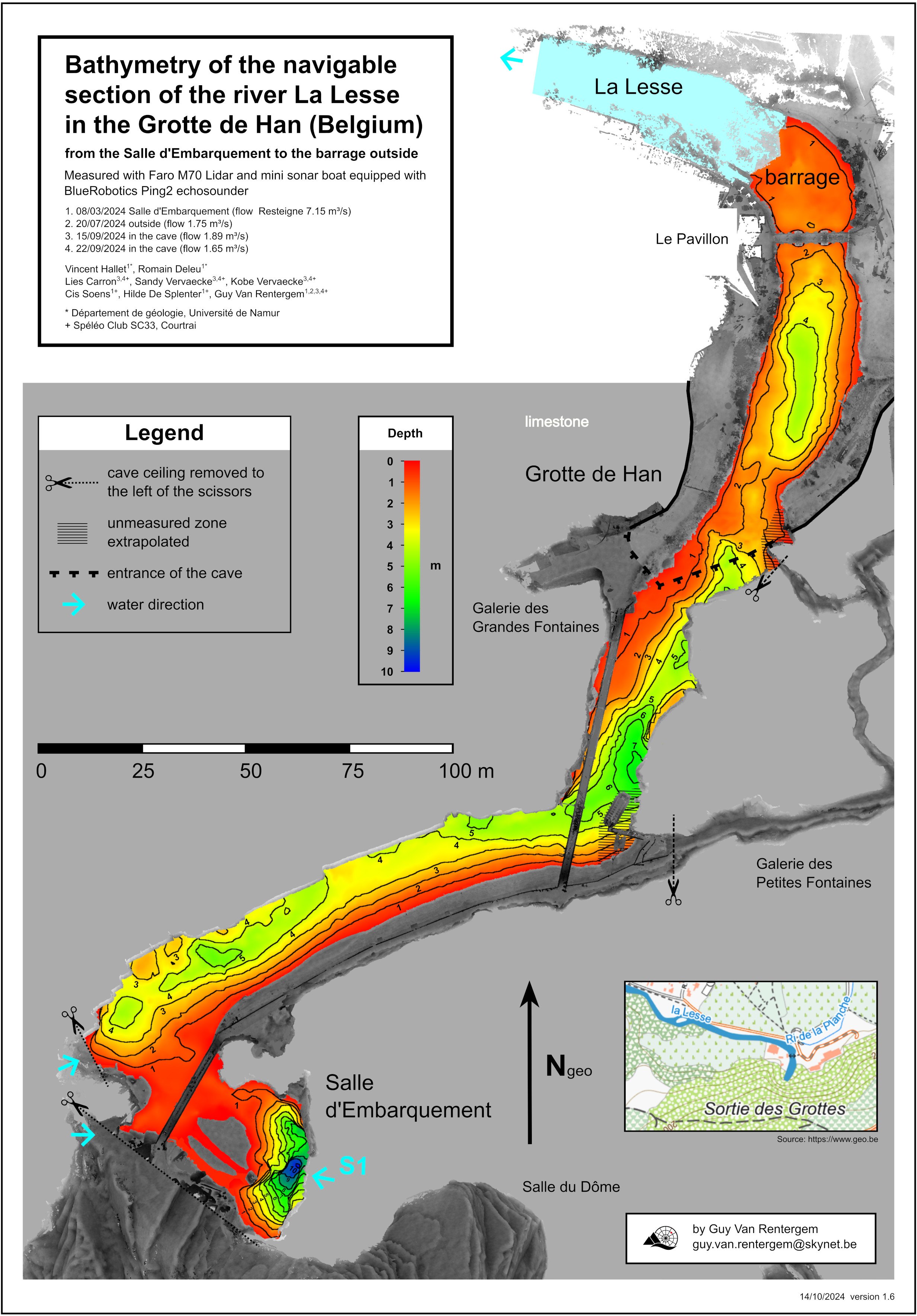
Once the Lesse enters the Grotte de Han, it passes through several more sumps before flowing into the Salle d’Embarquement. From there, it travels through a large external tunnel via the Trou de Han. A survey was conducted of this navigable section of the river, from the Salle d’Embarquement to the barrage outside (Fig. 5). As this distance is rather long for UWB technology, the measurements have been divided into eight sections.
In this project, the geometry of the riverbed was mapped and correlated with multipoint fluorescent dye tracing tests (Deleu, 2024). Dye tracing is a valuable technique that is often used in karst systems due to their complex and heterogeneous hydrogeology. It involves injecting a fluorescent dye into the water and tracking its movement using optical or manual monitoring tools, providing insights into groundwater flows and networks. For this project, TRAQUA’s STREAM fluorometers were used. These optical sensors detect fluorescent dye. Tracer tests involved placing multiple fluorometers at various locations, revealing significant heterogeneity in the results. This is due to the cave’s complex geometry, which induces variability in underground river hydrodynamics. The hydrogeological information obtained through the tracer tests provides a clear insights into the behaviour of underground rivers in karst systems. This extensive research will improve our understanding of karst aquifers and consequently help to preserve this vital resource.
References
Deleu, R. (2024). Hydrodynamics of solute transport in karst conduits: Assessment by multi-point dye tracing and numerical modelling [Doctoral dissertation, Université de Namur].
Poeter, E., Fan, Y., Cherry, J., Wood, W., Mackay, D. (2020). Groundwater in our water cycle – getting to know Earth’s most important fresh water source. The Groundwater Project, Guelph, Ontario, Canada. https://doi.org/10.21083/978-1-7770541-1-3