
1. Need for Hydrographic Services in Mauritius
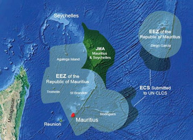
Mauritius is an Island nation of 2,040 Km2 situated 20° South of the Equator and on longitude 57.5° East with a large Exclusive Economic Zone (EEZ) of around 2.3 million Km2. In addition, an area of 396,000 Km2 of seabed in the Mascarene region is jointly managed by the Government of Mauritius and the Republic of Seychelles. This enormous EEZ provides the maritime state significant economic opportunities waiting to be embraced. Furthermore, sea borne trade is vital for our national and economic development.
The fragile coastal area requires environmental protection and management based on scientific research for sustainable development. Maritime security, environmental protection, ensuring safety of life at sea, marine scientific research and exploration for living and non-living resources in the vast EEZ hold the key to the future of Mauritius. The island nation is heavily dependent on sea borne trade for meeting requirements of energy and other essential commodities. Updated nautical products are one of the most essential tool for safety of navigation at sea and also the foundation for any further study and development in the marine environment. Therefore, fully evolved Hydrographic services are a critical instrument in realizing the government’s vision of ocean based economy.
Recognizing the vital and valuable role of hydrographic information in fulfilling the vision of ocean economy, the need for establishing hydrographic services at Mauritius was identified. The Hydrographic Unit, Mauritius was established in November 2013 consisting of surveyors from the Ministry of Housing and Lands (MHL) and hydrographers from the Indian Navy with the aim:
To develop indigenous capability of hydrographic surveying at Mauritius using the capacity building program and MoU on Hydrographic Cooperation.
The defined objectives were to:
- Carry out hydrographic surveys of navigable waters and passes around mainland Mauritius and outer Islands.
- Provide quality training in the field of hydrography to develop local expertise.
- Develop and strengthen hydrographic research capability.
- Provide nautical information to the international marine community for safe navigation.
- Provide hydrographic and geodetic data for the delimitation of maritime zones.
- Promote technical cooperation in the domain of hydrographic surveying and marine cartography.
- Provide training to surveyors, officers from MHL and other stakeholders in the field of hydrography.
- Cooperate with other stakeholders and provide expertise on matters related to maritime domain.
2. Achieving the Objectives
The goal of developing the hydrographic services was pursued in a systematic manner. The key steps followed were:
(a) Consultation with National Stakeholders: In addition to the seagoing fraternity, organizations related to marine navigation, protection of marine environment, tourism, maritime security, scientific research, disaster management, meteorology experts and ocean exploration are major stakeholders in hydrographic services. The identified stakeholders were consulted for their data requirements, areas of interest and were in parallel appraised of potential use of hydrographic services in their respective spheres.
(b) Compilation and Prioritization of Hydrographic Requirements: Coordination meetings were held for compiling the detailed survey requirements. A total of 112 requests were received during the initial interaction with various stakeholders resulting in 78 surveys in near shore/coastal areas and four deep sea surveys warranting ocean data collection for exploitation of resources. Requirements concerning expertise on matters related to coastal zone management, navigation and the delimitation of maritime boundaries emerged during the meetings. The requirements were prioritised based on available resources and importance of surveys towards maritime safety/development projects.
(c) Asset Operationalization and Management: Hydrographic equipment was received from the Governments of Japan and India in the year 2005 and 2013 respectively. The equipment was made operational in a phased manner with in-house efforts and innovation.
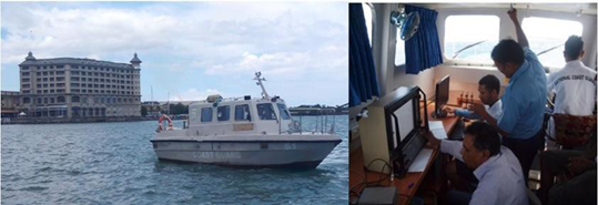
(i) Inshore Survey Vessel “Pathfinder”: This vessel was supplied by the Government of India in 2013. Its shallow draught and good maneuverability made the vessel ideal for operating in shallow, reefstrewn waters.
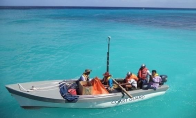
(ii) Portable Equipment: Harbour inspection and sea trials of portable equipment received from the Government of India and Japan was carried out. The vintage sets were re-energised and reconfigured to make the output data compatible with the modern data processing suite. Necessary modifications were carried out for deploying the equipment on-board any available craft of opportunity. The portable equipment later added the capability of collecting bathymetric data in extremely shallow lagoons.
(iii) Data Logging System: The hydrographic suite of ISV Pathfinder includes an echo sounder, satellite Differential Global Positioning System (DGPS), Dynamic Motion Sensor, data logging software, Side Scan Sonar (SSS) and Sound Velocity Profiler (SVP). The equipment were tested, serviced, configured, successfully interfaced and made fully operational in-house by the team.
(iv) Procurement of Additional Equipment and Establishing Office Infrastructure: The available inventory of equipment was considered insufficient considering the nature of operations envisaged. Therefore, after due deliberations, the following new additional equipment were procured:
- Very High Frequency (VHF) Radio and Emergency Position Indicating Radio Beacon (EPIRB) to enhance communication with shore authorities and safety of life at sea.
- Current meter (Infinity EM)
- Sound Velocity Probe (SVP)
- Seabed Grab
- Tide gauge
- Office infrastructure at Ministry of Housing & Lands (MHL), consisting of work- stations, digital data processing suite and necessary peripherals for producing CAD and hydrographic drawings.
- The Hydrographic Unit has recently procured and operationalized Portable Echo-Sounder Hydrotrac-II. A multipurpose portable pole has been designed in- house to mount the transducer on any craft of opportunity.
(d) Training and Human Resource Development: Trained and professional manpower is the bedrock of any successful organization and certainly, one of the main pillars of dependable hydrographic services. Formal training involving theoretical classes and On Job Training (OJT) were conducted for land surveyors of MHL, Survey Recorders of NCG and officers from other organisations. To date, numerous personnel have been trained. This includes Officers from MHL, Mauritius Oceanographic Institute (MOI), National Coast Guard (NCG), Mauritius Meteorological Services (MMS) and Ministry of Environment. The training encompasses the entire range of survey operations including planning and execution of surveys, data processing, rendering of data and compilation of hydrographic products. The surveyors are regularly exposed to emerging surveying techniques, latest equipment and developments in the fields related to hydrography for continuous skill development. Apart from the in-house training efforts, the officers from the MHL have also benefited from a number of IHO CAT A, CAT B and Diploma certification programs conducted by University of Southern Mississippi, University of New Hampshire and National Institute of Hydrography, India under various IHO Capacity Building Schemes.
(e) Establishing clearly defined procedures for data collection, processing, Quality Assurance, Quality Control and data archival as per IHO standards, to meet accuracy requirements for charting purpose.
(f) Enhancing cooperation with International Hydrographic Organization (IHO), South African Islands Hydrographic Commission (SAIHC), North Indian Ocean Hydrographic Commission (NIOHC) and utilising their capacity building programs for meeting cartographic and hydrographic training requirements.
(g) Streamlining procedures for correction, update and sales of nautical products. Focussing on providing updates to the mariner by establishing procedures for reporting, collation of navigational dangers and issuing Navigational Area warnings through the NAVAREA coordinator.
3. Enhancing Awareness about Hydrographic Services
As hydrography is a novel field in the country, very few individuals were previously exposed to the hydrographic profession and related services. In the beginning, introductory sessions and lectures on the role of hydrography in national development were organised for officers of various ministries and departments. Equipment demonstrations, interaction at various forums and conduct of World Hydrography Day (WHD) events on a grand scale have contributed immensely towards increasing awareness about hydrographic services.
(a) Establishing clearly defined procedures for data collection, processing, Quality Assurance, Quality Control and data archival as per IHO standards, to meet accuracy requirements for charting purpose.
(b) Enhancing cooperation with International Hydrographic Organization (IHO), South African Islands Hydrographic Commission (SAIHC), North Indian Ocean Hydrographic Commission (NIOHC) and utilising their capacity building programs for meeting cartographic and hydrographic training requirements.
(c) Streamlining procedures for correction, update and sales of nautical products. Focussing on providing updates to the mariner by establishing procedures for reporting, collation of navigational dangers and issuing Navigational Area warnings through the NAVAREA coordinator.
4. Results Achieved To Date
In the past two years, the hydrographic unit has grown from strength to strength, adding new survey capabilities and equipment. Expanding its reach to the outer islands of Mauritius has strengthened the Maritime Safety Information Services framework and is now well on its way to become a fully evolved Hydrographic Service capable of meeting the emerging requirements associated with the ocean economy.
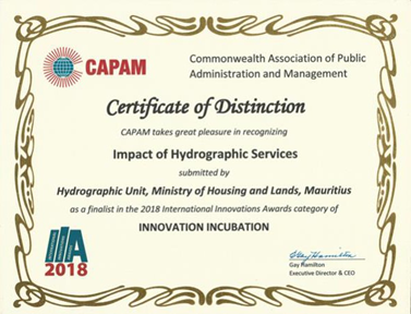
The efforts of the unit have been recognized at the International level, the Mauritius Hydrographic Service has been awarded the Certificate of Distinction as finalist during the International Innovation Awards (Figure 4) conducted by the Commonwealth Association for Public Administration and Management (CAPAM) at Guyana in 2018.
During the past five years, phenomenal success has been achieved in providing hydrographic services at the national level. Apart from supporting the seagoing fraternity, hydrographic services have been provided to the Continental Shelf, Maritime Zones Administration & Exploration Division – Prime Minister’s Office, Shipping Division, Mauritius Ports Authority (MPA), National Coast Guard, Department of Fisheries, Ministry of Tourism & External Communication, Ministry of Environment, Sustainable Development and Beach Nourishment, MOI, National Disaster Risk Reduction and Management Authority and Mauritius Meteorological Services. Our activities have contributed to the implementation of various projects of national importance.
Apart from 25 major hydrographic surveys undertaken by this Office, numerous other commitments to various stakeholders have also been fulfilled, including:
(a) Surveys of Passes around mainland Mauritius: The bathymetric data on the existing chart (INT 7737) Mauritius is inadequate for navigation through the passes due to sparse soundings and limited information on seabed topography. Bathymetry in lagoons is a critical input for storm surge and tsunami inundation modelling. Various other stakeholders also identified the requirement of surveying navigable passes in the lagoons. To address these multilateral requirements, the survey of 78 passes around Mauritius has been initiated. To date, 28 passes have been surveyed. The surveys completed cover from Grande Riviere Noire Bay in the south west to Cap Malheureux in the north of Mauritius.
(b) Data for implementation of Early Warning System for Storm Surge and Tsunami Modelling: Being an island nation in an equatorial region, Mauritius is under constant threat of storm surge. Bathymetric data surrounding Mauritius, Rodrigues and Agalega has been provided to establish the model for the storm surge early warning system. The model has significantly enhanced disaster management capabilities in case of such catastrophe.
(c) Data for Extended Continental Shelf Claim: Bathymetric data for supporting the extended continental shelf claim east of Rodrigues was provided to The Continental Shelf, Maritime Zones Administration & Exploration Division – Prime Minister’s Office.
(d) Charting Scheme for Mauritius: Finalization of the charting scheme consisting of 14 navigational charts covering Mauritius and other Islands in consultation with National Hydrographic Office, India. The new charting scheme will significantly enhance the navigational safety in Mauritian waters.
(e) Delineation of islets: A detailed survey was carried out for three newly formed islets north of Port Louis harbour. The detailed coordinates for the islands were forwarded for updating of national records.
(f) Interfacing of GIS data sets for enhancing scientific research and inundation modelling: To strengthen hydrographic research and improve appreciation of sea and land based topography to multiple agencies on a master fair sheet required numerous spatial and non-spatial data sets to be combined through innovative use of a wide variety of software tools.
(g) Survey for Petroleum Hub Project being developed at Albion.
(h) The unit has also developed capabilities to carry out hydrographic surveys for the support of outer islands around Mauritius including Rodrigues and Agalega to meet the requirements of various stakeholders.
(i) All the seven (07) series charts for Mauritius through collaboration with India have been accorded INT status.
5. Roadmap for the Future
Significant milestones have been achieved in terms of developing hydrographic capability. The expansion of the services is currently being pursued with a firm roadmap for the future. The main areas of focus are:
(a) Transition from current data processing practice to GIS-based processing and data compilation tools. Adding marine cartographic capability for paper chart compilation and implementing related Quality Control procedures.
(b) Establish maintenance and support procedures for specialized equipment to ensure sustained availability for hydrographic operations.
(c) Provide legal framework for hydrographic services.
(d) Develop deep sea surveying capability.
(e) Procurement of advanced hydrographic equipment suite like Portable MBES, ADCP, ROV, Unmanned Surface Vessels (USV), etc. suitable for this region.
6. Conclusion
Significant milestones have been achieved since the inception of this unit in 2013. The unit interacts on a regular basis with national and international agencies on matters related to Hydrography. Therefore, in order to better reflect its role and capabilities, the unit has been renamed the Mauritius Hydrographic Service.
As a result of establishing the hydrographic services, the country now has the capacity to survey areas critical for shipping and surface navigation, carry out underwater search operations for wreck/obstruction detection and survey of extremely shallow lagoons surrounding Mauritius for supporting economic/tourism related activities. In addition, significant progress has been made towards hydrographic support for scientific research and disaster management and expertise in matters related to maritime domain. The unit has now developed capability to independently undertake surveys in outer islands including Agalega and Rodrigues which are a few hundred miles from Mauritius.
Through innovation, resourcefulness and active support of the Ministry of Housing and Lands (MHL), seminal work in the field of hydrography has been carried out. The first steps taken in this novel field have the potential to bring the country closer to exploitation of huge ocean resources available in the surrounding waters.