


ABSTRACT
NaAVIC is a free and downloadable Electronic Chart System app, specifically developed for safe and professional navigation, functional on mobile devices and/or laptops. Downloading and updating of the electronic chart is not required because data is streamed in real-time from a cloud based open source database. The data supply engine behind NaAVIC is Nautilus Cloud, a cloud-based infrastructure designed for marine solutions and services that leverages high quality, open source components as its base technology. It uses open standards throughout to build a low-cost system which is flexible and has a much greater degree of interoperability. A key feature is the expansion of data holdings into a much wider family of related geospatial data products including the S-100 framework, harmonized metadata, raster and real-time sources. This enables the integration of real-time tides, weather, currents and other oceanographic information.
1. INTRODUCTION
1.1 Current chart carriage requirements
The International Maritime Organization (IMO, 2019) is the United Nations specialized agency with responsibility for the safety and security of shipping and the prevention of marine and atmospheric pollution by ships. The agency has established a comprehensive regulatory framework of over 50 international conventions and agreements that allow all of its 174 Member States to consistently implement and enforce a set of international maritime regulations.
The International Convention for the Safety of Life at Sea (SOLAS) is one of the key IMO conventions as it sets minimum safety standards. SOLAS, specifically Chapter V, sets forth the safety of navigation provisions applicable to all vessels on all voyages. A key safety provision is the requirement for all ships to carry up to date nautical charts and publications on board to be able to plan and execute the intended voyage safely. The same Chapter V defines additional provisions related to the use of an Electronic Chart Display and Information System (ECDIS) as an accepted way of meeting the chart carriage requirements.
1.2 Role of the International Hydrographic Organization (IHO)
Although the IMO is responsible for establishing all key safety provisions which require type approved ECDIS to be used in conjunction with up to date official ENC data, it is the IHO who develops and maintains the portfolio of relevant data standards (IHO 2019), including: S-57 for data content and encoding, S-52 for data rendering, S-58 for data validation, and S-63 for data protection specifically referenced by the IEC testing standard, which verifies an ECDIS against the IMO performance standard. The IHO is also working on the new family of S-100 standards that will eventually replace S-57 for ENC provision.
1.3 SOLAS and Non-SOLAS ships
The rules surrounding carriage requirements for ECDIS equipment have evolved considerably over the last 25 years. The implementation path gradually transitioned ECDIS equipment loaded with Electronic Navigational Charts (ENCs) from being approved as permitted replacement for paper charts in 2002 to eventually becoming a mandatory system for almost all vessels on international voyages in 2018.
The related rules were implemented using a rolling timetable factoring in vessel size, type and age to eventually make ECDIS mandatory for all vessels over 500 GT. This rolling implementation schedule distinguishes between the ships which must carry ECDIS and comply with all related provisions and those who do not. Fundamentally when an ECDIS is being used to satisfy SOLAS carriage requirements, it must: be type approved, have an adequate backup in place, be adequately maintained, remain compatible with the latest applicable International Hydrographic Organization (IHO) standards and use up to date ENC data.
1.4 One SOLAS convention – two different user communities
The ECDIS system is without a doubt one of the most significant advancements in marine navigation. The efforts of countless professionals are paying off and we are observing a well-established ecosystem with global data coverage, well established international standards, mature data distribution chains, and sophisticated bridge systems all greatly contributing to safety and operational efficiencies.
At the same time, outside the primary SOLAS community, there is a much larger Non-SOLAS user community of smaller, mainly recreational boat operators which has considerably different operational needs. This community also has markedly different service level expectations. Accustomed to an instant information delivery, these users expect to simply turn on a mobile app and start navigating with real time data simply “being there “, without having to go through a complex process of ordering official ENCs, waiting for them to arrive, manually uploading and updating them on a certified piece of equipment – the steps professional ECDIS users normally have to deal with.
2. INNOVATIONS
2.1 NaAVIC
NaAVIC is a free and downloadable ECS app that can function on any mobile Android or iOS device, where the data, including the ENC information, does not physically reside within the on-board device. The app offers a wide range of essential features needed to maintain safety and situational awareness while making navigation easier and more reliable. There is no downloading and local storage of data. All data, including chart data, is streamed in real-time from a fully maintained and up-to-date database. The data comes from the Nautilus Cloud, a cloud-based infrastructure specifically designed for marine data. The on-demand data delivery model is not confined to conventional chart data. Whilst it includes ENC-derived data as a base layer, it is also designed to take additional data layers, like raster satellite imagery, high-resolution bathymetry, weather radar imagery, predicted tides and currents, as well as real-time weather data streams and domain and locale-specific information.
The technology is designed to provide the basis for maintenance and distribution services for any marine data supplier. The Nautilus Cloud adopts a “cloud native” approach where the technology is built from components designed to run in cloud environments as well as leveraging open standards and open source components. The NaAVIC ECS can operate on real-time and up-to-date information from data providers. This can include the government agencies looking to make more efficient the accessibility to their data without compromising its integrity.
The app offers a comprehensive range of essential features needed to maintain safety and situational awareness while making navigation easier and more reliable. The result is a powerful and flexible system with a much greater degree of interoperability in its components. This compatibility includes the emerging S-100 framework, harmonized metadata, raster datasets and real-time sources.
2.2 Core Navigation features
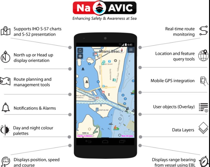
Designed to provide a top of the line navigation experience, the NaAVIC app incorporates functionality for increased safety and enjoyment, even for the unseasoned sailor. Unlike many other apps available in the market, NaAVIC provides full ENC support using familiar S-52 feature colours and styles. This allows mariners to view the same content as normally seen on a type approved ECDIS, as data is rendered with high quality in the same way, in the app.
With accurate positioning being essential to any voyage, the software application is integrated to the GPS on the mobile phone to allow for safe and intuitive navigation. This mobile GPS integration not only provides accurate positioning, but also underpins all the related functionality allowing for route planning and sharing using waypoints. Mariners can save and share the existing routes with other fellow mariners for improved voyages.
A set of features aid navigation by showing safety contours, maritime boundaries, navigation hazards etc. Since staying on course and avoiding hazards while following a route is tantamount to any seafarer, route monitoring is another feature that makes NaAVIC the go-to app for sailing. It integrates tools that make route monitoring simple and effective with alarms and indicators helping ensure safety and avoid accidents. The mariner can create scripts in English and other languages and can also view feature names in their local language. In addition, data layers can be activated and deactivated at will for an optimum view of a geographic area.
Figure 1 below provides a view of the app’s interphase and its key features.
2.3 Add on Features
On top of its core navigation functionality, the app also has Add on Features to provide extra confidence during sailing. Voyages and tracks can be stored to avoid repetitive tasks when transiting regularly through an area. The mariner can also add annotations to tracks and locations to record elements of interest found in the route and points of interest can be added or removed as needed. The mariner can plan voyages either online or offline for added convenience.
The app is also equipped with key navigation features like the capability to display high resolution bathymetric data and the details of wrecks and obstructions can be viewed in greater detail. Also, to make the app even more versatile, sailors can access online tides and weather data services to obtain a more complete picture of the area they are transiting through.
The goal is to provide the mariners with a complete view of the route, pairing features inherent to positioning and navigation with other important aspects like voyage info speed, bearing along with Estimated Time of Arrival, together with information on the next waypoint. Another exciting feature of the app is the capability to add Points of Interest during a voyage and the possibility to share them with fellow mariners and the sailing community in general.
As mentioned in the previous section, one of the essential navigation features of the app is the capability to set up warnings and alarms, allowing the mariners to stay alert in the face of route changes or potential navigation hazards like low depth areas, etc. (Figure 2)

2.4 Points of Interest
With its wide array of options and functionality, NaAVIC presents a significant value, especially to the recreational users, whose access to reliable and up to date information can become difficult due to them requiring a different level of service from data providing agencies. On the other hand, traditional hydrographic offices can now have access to a solution that can help provide fast and efficient services to this other large community of users of navigational data.
The app not only allows seafarers to navigate safely, but also implements all the benefits of modern mobile communications so that users can create communities and forums to stay in touch and send notifications to their fellow mariners on points of interest like hazards, fishing or diving areas or other elements that require attention during their voyage.
In addition, the Points of Interest feature can also provide access to detailed localized information about small craft facilities, local services, gas stations, current gas prices and many others that typically large vessels would not need. Recreational boaters can use this common information to know where they can get services for their vessels, where they can go for a nice dinner or where to get gas. This makes NaAVIC a socially able application as mariners can post and share reviews and opinions related to specific details like the quality of a marina as well as technical services or amenities available in any given area.
The importance of the Points of Interest feature becomes even more relevant to the sailors as it allows them to share and access information that is not included in the chart, pushing the versatility of the app beyond the use of cartographic information for safe navigation.
2.5 The Nautilus Cloud Framework
The data powering the ECS is supplied by Nautilus Cloud, a cloud-based platform for marine data, designed for solutions and services within government organizations, industry and consumers. Nautilus Cloud is an enterprise-grade system which is both flexible and has a much greater degree of interoperability with pre-existing components and multiple data sources. As such, Nautilus Cloud is optimized for import, validation, and data management, as well as commercial distribution of marine geospatial data for government organizations, the marine industry, and end consumers. Figure 3 illustrates the many additional ECS features that are supported by the Nautilus Cloud framework.

2.6 Key benefits
One of the key features of Nautilus Cloud is the expansion of data holdings into a much wider family of related geospatial data products. It is designed to handle the many forms of marine geospatial data under the emerging IHO S-100 framework. The modular design allows front-end applications to access the spatial data feed on any platform, from desktop and mobile platforms to OGC-compliant (OGC 2019) web service clients and web map tile services for onward consumption of data by other organizations.
The NaAVIC ECS app takes full advantage of many advanced features provided by Nautilus Cloud making it possible for charting agencies to distribute pre-updated data in real-time. This includes distribution of temporal services such as tides, weather, currents and other oceanographic data. This achieves a group of three important requirements for the ECS: content, quality, and data updating.
2.7 Reliability of data delivery
NaAVIC addresses the concern of reliable internet connection by providing a smart, user-controlled data caching functionality. It is capable of automatically caching data to ensure consistent availability. Users, based on their environment, will be able to set the app to auto-cache required data ahead of time for a predefined area. Alternatively, they can interactively define the area to cache before departure. Even for users using the app in nearshore coastal areas where modern data networks have coverage readily available however, caching can fulfill an important redundancy feature.
2.8 Key enablers
The Nautilus Cloud platform has the following key features:
– A ’cloud-native’ approach where the technology is built from components designed to be run solely from cloud environments.
– A strong integration between data distribution and storage/management.
– A system leveraging open source components as its base technology and which utilizes open standards exclusively building a low-cost system which is flexible with a great degree of interoperability.
2.9 Connecting the data producer and end user
The approach taken is a conscious attempt to connect the user with the producer of nautical data. This closer engagement between supplier and consumer is a phenomenon often seen across the many domains in the geospatial industry. Data holdings are ever expanding and becoming more accessible, and under a common framework, S-100, which provides unparalleled opportunities for compatibility and interoperability between previously unrelated marine geospatial domains.
This approach facilitates ’pluggable’ architecture and allows for extensible, customizable data imports into the system, future-proofing it for a wide variety of organizational use cases. Additionally, a metadata management sub-system provides functionality to allow individual customers to easily generate metadata records compliant with their individual national metadata profiles.
More closely connecting the data produced and end user also aligns well with the overall Marine Spatial Data Infrastructure (MSDI) vision for the data exchange between various user communities in the marine domain. A case could be made that in the future applications like NaAVIC should be able to connect to the MSDI systems hosted by the national agencies and dynamically discover and consume navigational data as needed in real-time. While this concept might seem as something too futuristic now in reality it is not. The current NaAVIC app coupled with the Nautilus Cloud infrastructure effectively realizes this very idea in practice and adding more distributed nodes to this system to enable data to be streamed by multiple agencies is certainly achievable using our current platform.
2.10 Intelligent voyage visualization
NaAVIC and the Nautilus Cloud also aim to support the next generation of Intelligent Visualization technology – “the right information at the right time ” – adding a completely new dimension of customization to traditional geospatial data rendering engines. This will make data intuitively useable for end users and, through web services, to onward systems and derived applications. This technology aims to solve the issue of properly balancing the availability of a wide range of data layers available but only selectively displaying those of most relevance to the task at hand.
2.11 Sharing the journey
We are seeing with land-based journeys and within recreational activities as a whole, that users want to share. The desire to share individual experiences comes with a desire to benefit from collective experiences of like-minded people. This has propelled social media to be the preeminent guidebook.
Up until now, ECS catered to the person controlling all aspects of the vessel, including its navigation. By utilizing a cloud-based approach with data streaming, NaAVIC ECS enables all members of an expedition to more actively engage in the voyage as well as sharing that voyage to fellow ’marine friends’. It provides ways for everyone to have a more enjoyable boating experience, providing an easy way to monitor the route with the main navigator, to see the basic boat information such as location, speed and heading, and exchange information about various points of interest with friends.
All users get access to community features, which include the capability to post messages, share pictures, locations and to record and share voyages. Users can also add location sensitive notifications. The app also enables crowdsourcing activities by allowing users to use a set of pre-defined icons to capture items of interest to specific communities. For example, marking new diving spot locations for the diving user community is as easy as dropping a marker and the platform will automatically share it with all other users, a specific group. Users can also keep all information private if they want to keep their findings to themselves!
2.12 Flexible Business Model
Nautilus Cloud’s commercial distribution interface can assist organizations who need to sell data as part of their operating model. By offering both free and paid access to data, the system gives organizations the ability to switch between free and cost-recovery models as their demands dictate. It allows the substitution of multiple disparate systems which may be already in place, with a system at substantially lower costs for implementation and support.
The system uses a highly standardized data output interface and a comprehensive approach to data integrity which is crucial in the modern marine data environment. By providing open and efficient access to marine data, the system facilitates social and environmental value (e.g. providing easy standardized access for data to be used for marine pollution prevention, alternative energy production and marine research).
3. DATA NEEDS OF NON-SOLAS USER COMMUNITY
3.1 Initial response to NaAVIC
Ever since the original NaAVIC release back in 2018 we have enjoyed a positive response from the recreational boating communities and from various workboat communities alike. We have also seen NaAVIC steadily growing in popularity month over month, opening the opportunities for us to get comprehensive feedback directly from the end users. In general, NaAVIC users are very enthusiastic about the data streaming aspects and the app simply working out of the box without the need for manual chart data installation as this the model they are familiar with from using other mobile apps. Similarly, they appreciate a balance between the higher-end navigational features and more fun oriented social sharing aspects.
3.2 Use of ENCs by Non-SOLAS user community
Interacting with NaAVIC users also enabled us to learn more about their existing chart and chart data use patterns. Although we have not conducted a systematic study, our internal findings indicate that recreational boaters do not generally use the up to date products available. Instead, they often use a combination of outdated paper/raster chart products or 3rd party vector charts that have not been updated since they have acquired them, typically along with the equipment. The use of ENCs within the recreational boating seems to be minimal. The main reasons behind what appears to be a very limited ENC adoption are: costs, inconvenience of having to manually install and keep them update to date, as well as perceived low value proposition offered.
3.3 Increasing ENC adoption by Non-SOLAS user community
The contrast between the enthusiastic adoption of streamed, up to date ENC information provided by NaAVIC app and the limited adoption of ENC data otherwise by the same user group is a good indication that NON-SOLAS user community expects much different value proposition to be provided by the national hydrographic agencies. One which offers them the convenience of maintenance free portfolio of vector data at a much lower cost, ideally free of charge. In most countries, the current ENC licensing and cost recovery models make it very difficult for the recreational boaters to adopt ENCs in practice.
Moving away from the traditional distribution model and using cloud-based infrastructure to stream the data instead while lowering the cost of data for Non-SOLAS use could dramatically change that. Doing so would have very minimal impact on the operational costs but would deliver a significant public benefit by radically increasing safety for recreational boaters.
4. CONCLUSION
NaAVIC is a free and downloadable mobile ECS that represents a new approach where the electronic chart data does not physically exist within the onboard computer. After several years of continuous improvement and with an integrated team of developers and support staffers, NaAVIC has reached a maturity that makes it the ideal solution for small craft and recreational mariners. It is IIC Technologies´ goal to continue improving the app so it can become an irreplaceable tool for any serious mariner.
The app attempts to thrust the sailing experience several steps further with all the features it offers to its users. The system provides a flexible business model by facilitating the ability to switch between free and cost-recovery models of data distribution as their requirements dictate.
While the NaAVIC app mainly targets the Non-SOLAS user community, it showcases many advanced capabilities for both the app and the underlying Nautilus Cloud that could be very useful for the SOLAS community as well. It is our goal to see these innovations eventually transitioning into both communities as we believe they would benefit greatly vessels alike. Some of the innovations described aim to inspire both communities to see that the possibilities of streaming marine data real-time, consolidating multiple data sources and providing consistent data access to them is currently achievable. These advances can be used to power the next generation of ECDIS and ECS systems untimely benefiting all mariners.
5. REFERENCES
IMO (2019a). Introduction to the International Maritime Organization (IMO). Viewed on 7 August 2019, http://www.imo.org/en/About/Pages/Default.aspx.
IMO (2019b). International Maritime Organization. International Convention for the Safety of Life at Sea (SOLAS), 1974, viewed on 7 August 2019, http://www.imo.org/en/about/conventions/listofconventions/pages/international-convention-for-the-safety-of-life-at-sea-(solas),-1974.aspx.
IHO (2019). International Hydrographic Organization (IHO) Publications, viewed on 7 August 2019, http://www.iho.int/downloads.
OGC (2019). Open Geospatial Consortium (OGC) Standards, viewed on 7 August 2019, https://www.opengeospatial.org/docs/is.