
Abstract
Preamble
The following work was presented at the Hydrographic Conference HYDRO 2024, 5–7 November 2024, Rostock-Warnemünde, Germany in the oral session New trends in positioning.
1 Introduction
In Fugro’s continuous efforts to improve GNSS positioning accuracy, various services making use of the L-band of geostationary satellites have been developed since 1997. MarinestarTM is one of the services that currently provides precise orbit, clock, and phase bias corrections of satellites to marine clients. These corrections enable precise point positioning (PPP) with integer ambiguity resolution (IAR) with almost the same accuracy as traditional real time kinematic (RTK) produces, without using reference stations nearby. The service supports four constellations: GPS, Galileo, BeiDou, and GLONASS, with approximately 120 satellites in total. This article highlights several enhancements to the service achieved in 2024, with a focus on faster convergence, higher accuracy, scintillation mitigation, and anti-spoofing.

2 Network configuration
The reference network consists of 130 reference stations with Trimble NetR5, NetR9, Alloy and Septentrio PolaRx5 GNSS receivers. Two GNSS manufacturers are used so the orbit and clock calculations can continue if one of the receiver types fail. The orbit and clocks for GPS, Galileo, BeiDou and GLONASS (G4) are calculated in three calculation centres in Norway, Sweden, and Germany. At each location at least two independent computers calculate orbit and clock solutions. There are two network control centres each with a backup to continue to work in case of hurricanes, power, or major internet outages. One of the backups is now cloud-based. Using the cloud improves robustness against local or regional hazards such as for example, hurricanes and power outages.
There are six geostationary L-band satellites with two uplink locations. There is one primary uplink and a backup uplink in case of bad weather, power, or internet outages.
Over the geostationary L-band satellites orbit and clock corrections are sent for G4 and XP3.

3 XP3
Using independent orbit and clock sources from a third-party GPS and GLONASS corrections have been broadcast since 2006. The main purpose of XP is to increase independent solutions for the dynamic position market. In 2024 corrections for Galileo have been added improving the robustness of this independent service considerably against local radio interference and ionospheric scintillation. Adding Galileo increases the average number of satellites from ~15 to ~22 satellites and the addition of Galileo E5ab adds an independent frequency making the solution less sensitive to radio interference.
4 Triple frequency implementation
A significant improvement in 2024 involves the addition of third-frequency phase biases and inter-frequency code biases of Galileo and BeiDou for the Integer Ambiguity resolution to the existing dual-frequency service. This enhancement allows clients to utilize the third frequency GNSS measurements in conjunction with more reliable and intelligent Integer Ambiguity Resolution strategies. This enhancement has been notably contributed to faster convergence and higher accuracy.
From the three frequencies by adding the frequencies L1+L2 and L1+L3 two narrow lanes with wavelengths in the order of 10 cm can be constructed. By subtracting the frequencies L1-L2 and L1-L3 wide lanes with wavelengths of 80 to 100 cm can be made. Combining the lanes using the MLambda integer search technique allows for much faster fixing of the correct ambiguities and thus faster convergence time.


5 Global position accuracy
Using measurements of 24 globally spread GNSS reference stations for 10 days 95 % north accuracies between 10–16 mm and east 10–15 mm and height 30–50 mm was achieved. Every hour the position calculation was restarted. See Fig. 4.

6 Convergence time
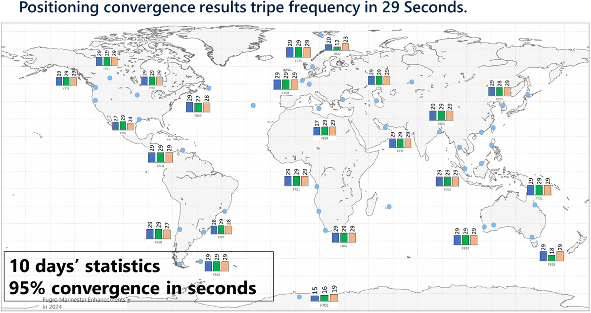
The convergence time is defined as 95 % of the samples are better than 10 cm for height and better than 5 cm for north and east. The convergence time has been reduced from approximately 12 minutes to better than 3 minutes (95 %), while the accuracy has seen a global improvement to 2.5 cm horizontally and 5.0 cm vertically (95 %). Many ideal experimental sites have achieved even higher accuracy, reaching 1.5 cm horizontally and 3.5 cm vertically (95 %), with almost instantaneous convergence (with one minute). See Fig. 5.
Resetting the solutions every hour in a period of 10 days gives nominal 29 seconds for the north and east to be better than 5 cm and 10 cm for height in 95 % of the 240 restarts.
7 Scintillation position improvements
From 2022 until 2027, ionospheric scintillation is experiencing a period of high activity, with an expected peak in 2025. Scintillation is frequently observed near the equator and in the Arctic region, where many of Fugro’s clients have ongoing engineering projects. As a result, GNSS measurements are significantly degraded, leading to positioning with much lower accuracy and occasional positioning resets. The largest improvement is by adding BeiDou3 with 36 nominal satellites in 2023 increasing the used GNSS satellites from 30 to 40 satellites. To further improve scintillation handling, Fugro enhanced its PPP engine with various level of quality controls in 2024. These improvements have effectively mitigated or largely reduced the impact of scintillation. Consequently, the position performance is now significantly better than it was before.
8 Satguard spoofing mitigation
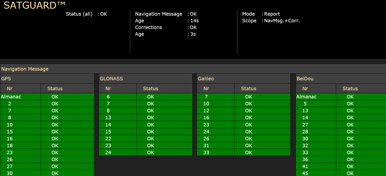
GNSS signal spoofing represents an intelligent and sophisticated form of signal interference, where malicious actors may employ a device to transmit fake GNSS ephemeris, measurements, or corrections, deceiving a receiver into calculating an incorrect position. Fugro has introduced the authentication service Satguard®, which has the capability to distinguish fake and true signals (i.e. navigation messages and corrections) from the four constellations. The service offers an opportunity to prevent the injection of fake signals into the PPP engine, thereby, ensuring accurate positioning for clients. The raw ephemeris is collected from all reference stations in the world. The ephemeris sources are compared and verified and a hash per ephemeris is created. The hash is a cryptographic code which is used to verify that the ephemeris is original and has not been modified. This checksum is broadcasted over the L-band. Also, the corrections do have a checksum which is broadcast.
The NMEA GGA Station ID is used to show the state of the receiver.
9 Atomichron
As timing is also relevant for offshore operations Fugro has added Satguard® to the timing service. Atomichron timing service is than 1 nanosecond. This is achieved by broadcasting the difference in system time of GPS, GLONASS, Galileo and BeiDou to a Fugro timing standard, which is close to UTC. This precise time can be used in timing operations to prevent time spoofing.
10 Conclusion
The 2024 enhancements to Fugro’s GNSS PPP service have significantly advanced its technical capabilities. The integration of triple-frequency phase biases and inter-frequency code biases for GPS, Galileo, and BeiDou has resulted in faster convergence times and higher positioning accuracy. The addition of Galileo corrections to XP3 has increased the robustness of the service against local radio interference and ionospheric scintillation, with the average number of satellites used rising from approximately 15 to 22.
The improved PPP engine, with enhanced quality controls, has effectively mitigated the impact of scintillation, particularly in equatorial and Arctic regions. Furthermore, the introduction of the Satguard® authentication service provides a robust mechanism to detect and prevent GNSS signal spoofing, ensuring the integrity and reliability of positioning data. These technical advancements collectively enhance the precision, reliability, and security of the Marinestar service for marine applications.