

Abstract
Preamble
The following work was presented at the Hydrographic Conference HYDRO 2024, 5–7 November 2024, Rostock-Warnemünde, Germany in the oral session Quality aspects of MBES measurements.
1 Introduction
In order to assess the quality of the bathymetric and backscatter (BS) datasets from different multibeam systems and different vessels, a reference area on the Belgian part of the North Sea has been established: the Kwinte area. This natural reference area has been included in the Marine Spatial Plan (MSP) 2020–20261 for the Belgian Part of the North Sea as a reference area for the calibration and quality evaluation of measuring devices. In practice, all seabed disturbing activities are prohibited inside this area in order to preserve at long term an undisturbed seabed for bathymetric and BS measurements. Extensive survey work by Flemish Hydrography (VH)2, Continental Shelf Service (COPCO)3 and other participants to this project has been carried out during the last decade here. Multiple surveys allow to cross check the depths and positioning of the different measurements and to build up a reference bathymetric model of the area.
The purpose of this conference paper is to present the essential information about the Kwinte reference area and to show how it can be used for both bathymetry and BS data quality control and calibration. The results were presented during the Hydro 2024 conference in November 2024 in Rostock, Germany.
2 Location
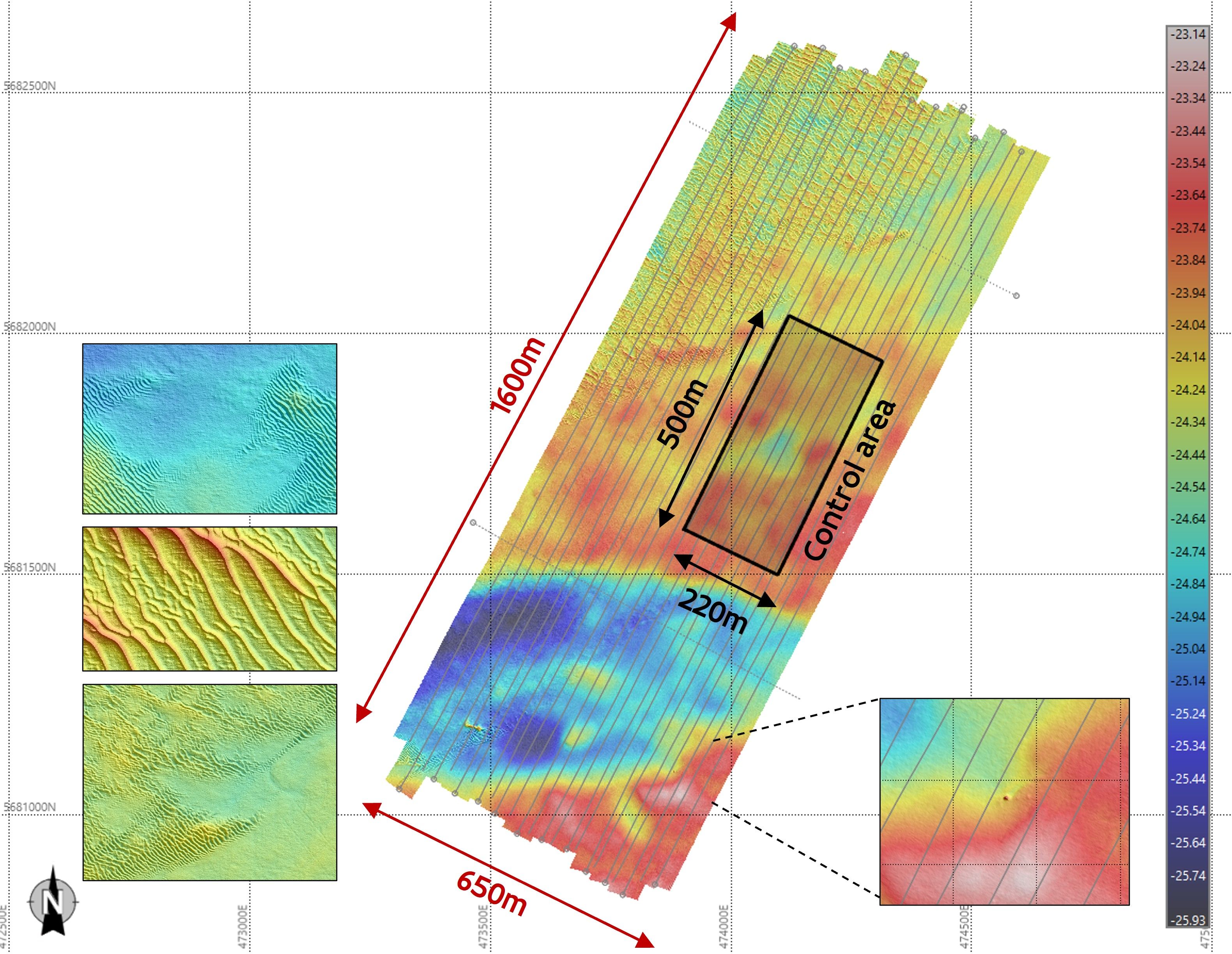
The Kwinte reference area lies 17 km from the coast in the gulley between two sandbanks (Fig. 1). It has a length of 1,5 km and a width of 650 m, with depths ranging from 23 to 26 m LAT (Fig. 2). The area is to a large extent flat. Slope breaks affect its southern part. The NW part is shaped by a network of small to medium dunes of 10–30 m wave length. No dunes are observed in the SE part of the larger Kwinte area, which is dominated by rounded and irregular hills and depressions of decimetric height forming a typical hillocky morphology, characteristic of the relatively flat gravel areas of the troughs between sandbanks. In the Kwinte channel, tidal currents can reach up to
1 m/s during periods of spring tides and remain around 0,5 m/s during neap tides. The sedimentary cover of the Kwinte reference area consists of gravelly sand (gS) and sandy gravel (sG) with a high carbonate content exceeding 15 %, due to the abundance of shells. This composition has been verified through four series of Van Veen grab samples and Sediment Profile Imaging (SPI) system images collected from 2001 to 2022.
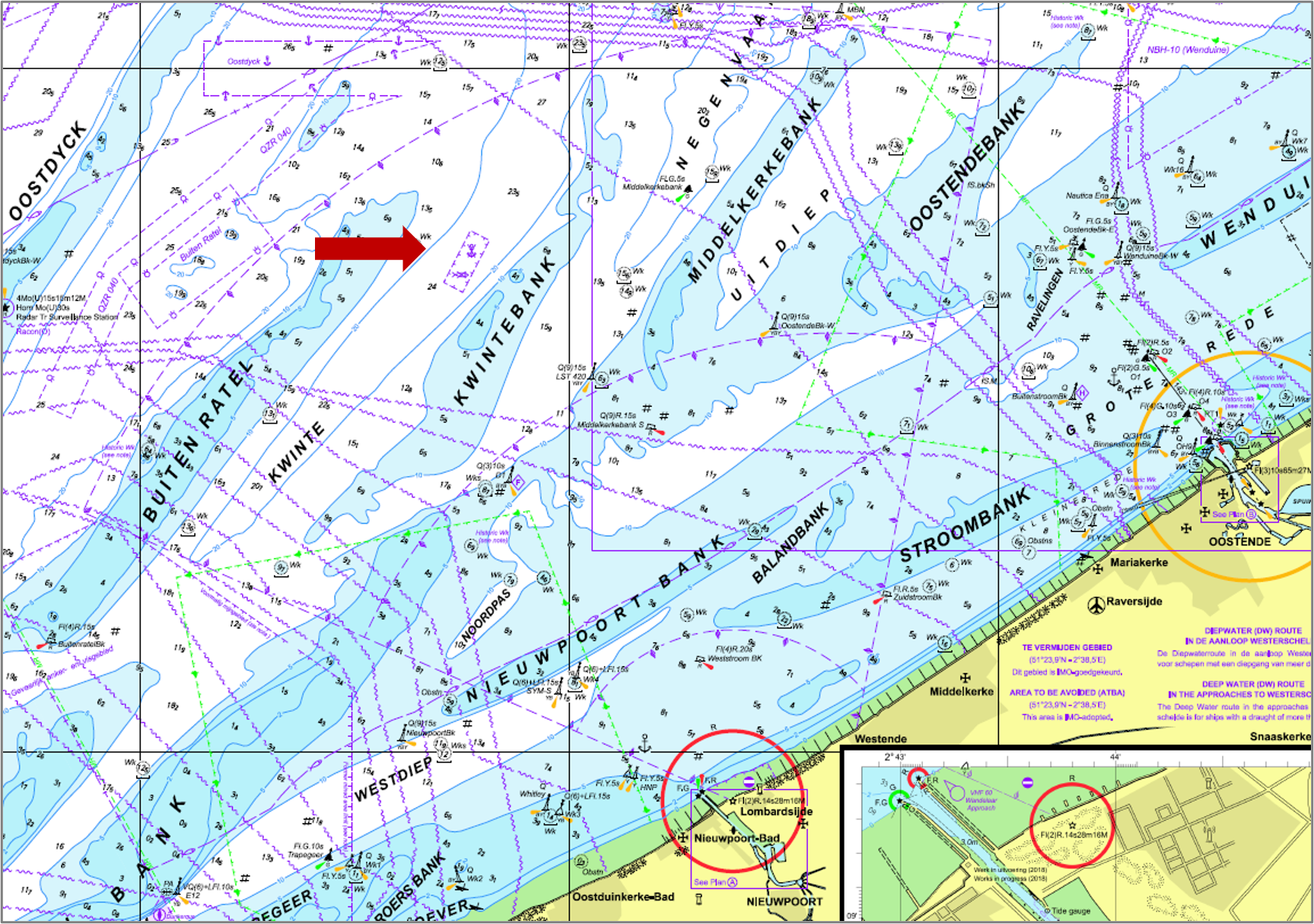

The Kwinte area is defined in the current Marine Spatial Plan (MSP) 2020–2026 and will be kept in the follow-up MSP 2026-2032 as an area where seabed disturbing activities are prohibited. Seabed anthropic alteration cannot be overlooked, as trawling marks are clearly visible on some BS images of the Kwinte area. Any impact by human activities (trawls, anchors, dredging, …) on the seabed surface will change the bathymetry and by modifying the sediments, inducing a change of the BS level. This human impact has to be excluded to assess the natural value of the calibration area. During the last few years there has been less impact but nevertheless some fishermen still trawl in the area. A control mechanism by the authorising government has been put in place.
3 History
In 2003, COPCO selected the Kwinte area as a reference site for sandy gravels during the development of a supervised acoustic classification system for surficial sediments in the sand extraction areas of the Belgian part of the North Sea. This classification system was based on backscatter (BS) data from a 100 kHz Kongsberg Discovery EM1002 MBES.
Subsequently, as part of monitoring the impact of sand extraction on the marine environment, this small area was considered by COPCO as a control area and measured sporadically. Over the years, it became clear that the Kwinte area was very stable, both in terms of bathymetry and BS.
Since 2009, extensive surveys of the Kwinte area have been carried out by COPCO and VH using multiple MBESs installed on several vessels, with different setups and at different times. The resulting long time series of bathymetric and BS data demonstrates that the seabed remains remarkably stable throughout the years (Fig. 3). Over a period of 10 years, the Kwinte area shows neither significant accretion nor erosion of the seabed. This demonstrated stability gives the Kwinte area the status of an ideal natural reference area for controlling the hydrographic quality of bathymetry measurements. Due to the stable seabed in terms of morphology and sedimentology, it is also an ideal reference area for controlling the repeatability of BS measurements done by individual MBES.

In 2023, a collaborative effort with Ifremer (France) on board the HV Sirius enabled the acquisition of reference BS angular responses by employing a single-beam echo sounder (SBES) that had undergone meticulous calibration using reference spheres prior to deployment. The recorded frequencies, ranging from 50 kHz to 400 kHz, encompass a substantial frequency spectrum, including the frequencies typically utilized by shallow-water MBESs. The calibrated BS angular responses resulting from these measurements constitute the reference BS levels that allow the BS from any MBESs operating at comparable frequencies to be calibrated.
Since its incorporation into the MSP 2020–2026, the Kwinte area has been maintained as accessible and open, with the objective of encouraging all users of MBES to visit and assess the quality of their data by sharing their measurements with VH and COPCO, fostering a mutually beneficial relationship (Deleu & Roche, 2020).
Contracting survey companies working for VH are obliged to carry out a series of acceptance tests prior to the start of the first survey. Only when they pass the tests successfully, can they start the contract and carry out hydrographic MBES measurements with the used vessel and setup. The final test is a survey on the Kwinte area, as it is a very stable and well-known area and gives VH the necessary confidence regarding data quality.
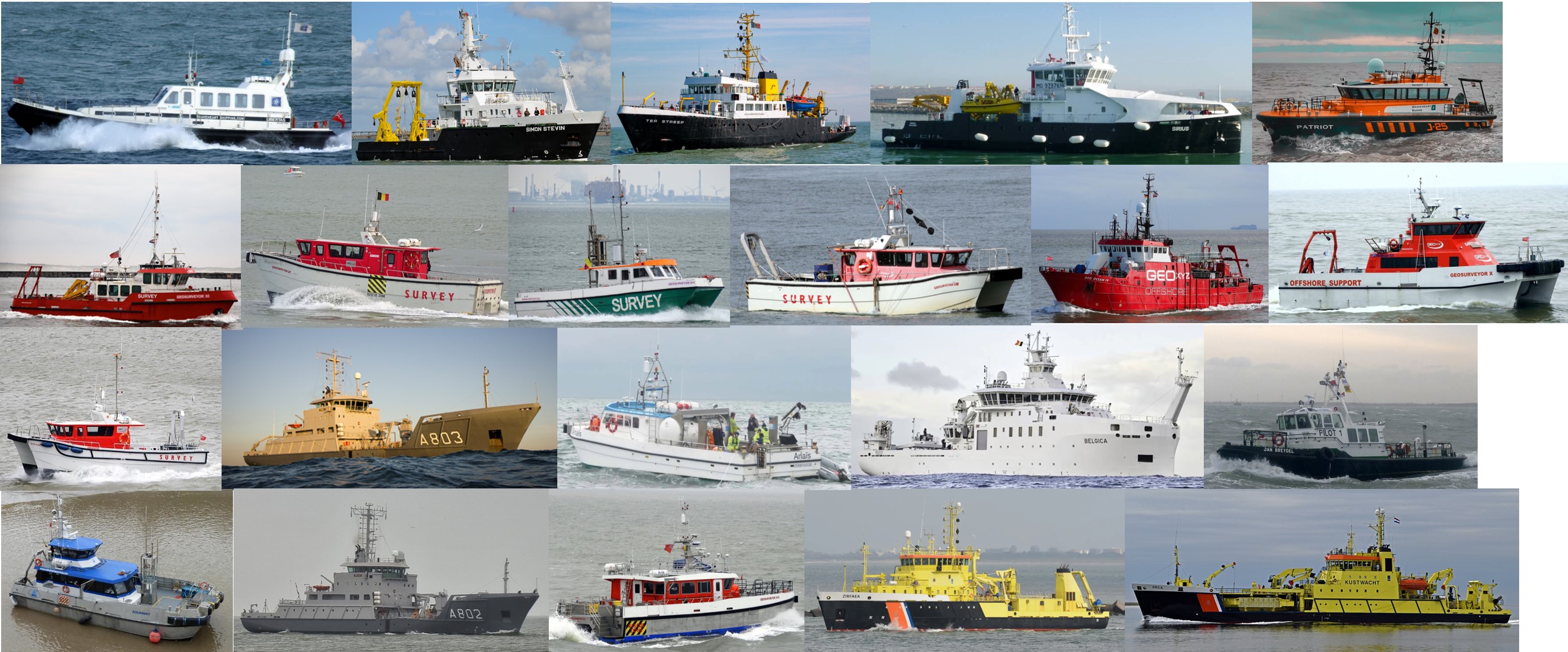
The accessibility of the Kwinte area, coupled with the VH contractual imperative to utilize it for hydrographic data quality control, has resulted in a substantial accumulation of bathymetric data collected by a diverse array of MBESs deployed on various Belgian and Dutch vessels (Fig. 4).
Over the past two years, the potential of the Kwinte area to evaluate the quality and calibration of BS data has begun to garner attention from numerous surveyors, and this interest is anticipated to escalate in the forthcoming years.
4 Results
4.1 Bathymetry
The effective control area is focused on a sub area within the Kwinte area with a demonstrated flat seabed. The mean depth value of this control area (Fig. 2) is around -24.00 m LAT which means that, following the International Hydrographic Organization (IHO) Exclusive Order Limits (using the Matrix Reference; IHO, 2022), the Maximum Allowable Vertical Uncertainty TVUmax) is around 0.23 m, using the following formula:
 |
(1) |
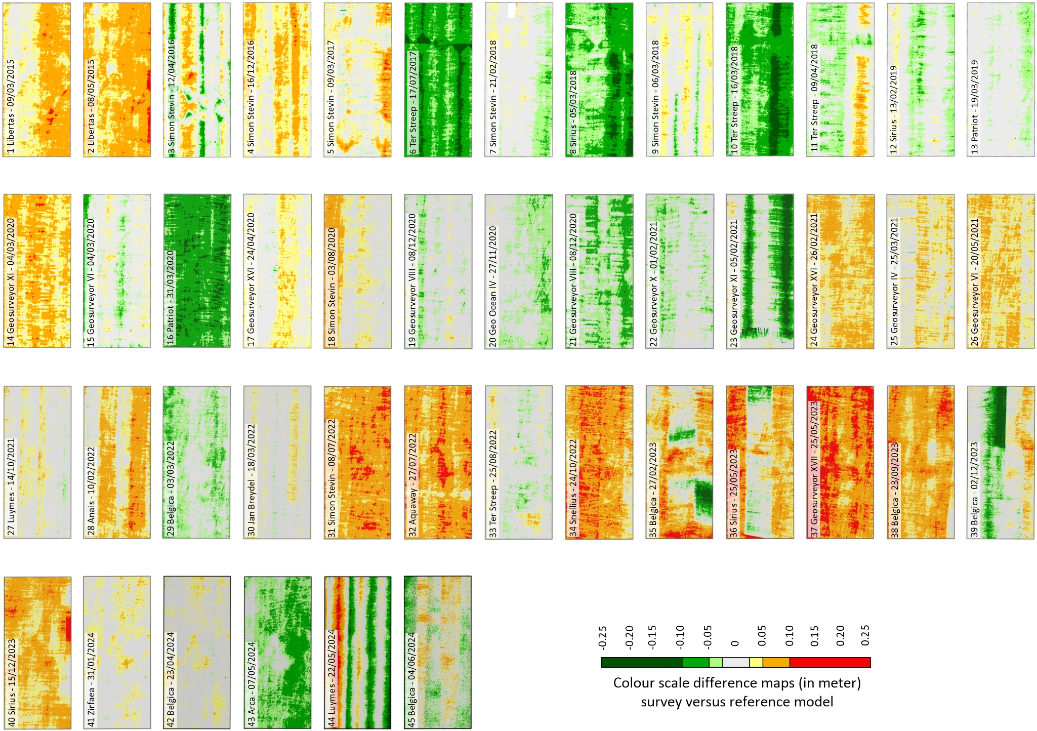
Before everything else, datasets are examined on overlap, visible artefacts, spikes, confidence levels, statistical analysis and checked with reference to the TVU of the IHO Exclusive Order Norm. Difference maps are generated to compare each survey with any other survey and with the model (Fig. 5).
After each accepted new survey, the model is updated. A mean value per survey on a small subarea is calculated for each survey and plotted in time with reference to the mean model value and the IHO Exclusive Order Norm limits (Fig. 6). Up until now 45 surveys are accepted, with the first accepted survey being done in 2015. The time span of 10 years does not reveal a trend in bathymetry which ensures us that the area is bathymetric stable. Next to the 45 accepted surveys a number of surveys did not pass the acceptance criteria and are not included in the pipeline of accepted surveys. Some of the reasons up until now are: not enough data points, mean value out of limits IHO Exclusive order, too much noise and spikes, too many motion artefacts and bad positioning accuracy.
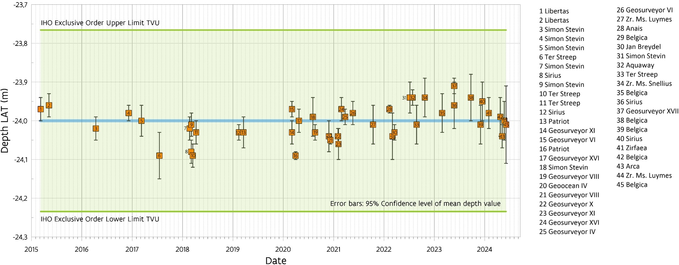
For each survey, statistics are calculated and a whole table of these is stored to assess the quality of that survey. Some of the used parameters are: 95 % confidence levels, amount of accepted and rejected footprints, hit count, span and differences towards the model. The results of all these analyses determine if a new survey is accepted or not and provides certainty of the quality of the multibeam setup. It is also used as the final control during acceptance tests for survey companies carrying out survey work on the Belgian part of the North Sea for Flemish Hydrography. If the survey does not pass, that specific vessel with that specific multibeam setup cannot be used for survey work until a new survey on the Kwinte area is accepted.
In the southern part of the reference area, a clear object can be detected (Fig. 2). Its shape is conical, which makes the shallowest point an ideal control point for horizontal uncertainty. The coordinates of the shallowest point of this object or all accepted surveys are plotted with reference towards the Total horizontal uncertainty (THU) based on the IHO Exclusive Order. This gives a good idea if the used geodetic settings and lever arms are correct.
4.2 Backscatter
MBES BS is commonly used to map habitats and sediments. In the sand extraction areas of the Belgian part of the North Sea, BS has also been used since 1999 as a proxy to monitor changes in the seabed related to dredging activities. However, from 1999 to 2009 the BS remained uncalibrated with poorly controlled quality and repeatability. These shortcomings have prevented the cross-comparability of data collected by different MBES carried by different vessels, limiting the use of BS in monitoring programs to BS time series collected with a single MBES on one vessel.
Since 2013, the Backscatter Working Group (BSWG) has been working to establish practical methods for achieving quality control and calibration of MBES BS data (Lurton et al., 2015). Natural reference areas have emerged as a pragmatic solution to this problem (Eleftherakis et al., 2018). The approach, which relies on the stability of the seafloor of the natural reference area, allows for three main objectives: 1. Cross calibration using reference measurements from a pre-calibrated singlebeam echosounder (SBES); 2. Repeatability assessment through regular MBES measurements in the reference area as part of monitoring programs and 3. Data comparability measurements from different MBES systems by using data collected in the same reference area (Roche et al., 2018).
The Kwinte natural reference area, characterized by shallow bathymetry, homogeneous sediment cover and low temporal variability, provides stable and consistent characteristics essential for the BS calibration, quality and repeatability control.
Calibration in a natural reference area requires angular BS response curves (ARC) from measurements made in the same area using a calibrated singlebeam echo sounder (SBES). Through a partnership with Ifremer (France), the reference ARC’s were obtained in the Kwinte area between May 22 and 25, 2023, using three Kongsberg Discovery (KD) EK80 SBES transducers installed on the HV Sirius, covering frequencies from 50 kHz to 440 kHz (Fig. 7a). The transducers, mounted on a pan-and-tilt device, were deployed in the HV Sirius moonpool (Fig. 7b). A reference sphere was used to calibrate the EK80 transducers. The pan and tilt unit was remotely controlled from the bridge, rotating the transducers between -10° and +75° in 5° increments. The survey covered 18 lines in both directions per frequency, creating a detailed reference library of ARC’s for the Kwinte area (Fig. 7c). These calibrated angular responses serve as a reference for the calibration of the MBES BS (Fezzani & Berger, 2023). For frequencies from 50 kHz to 250 kHz, the average BS level in the ±[30°,50°] angular incidence range varies linearly from -15.5 dB to -11.5 dB. After 250 kHz, the average BS level stabilizes at about -11.5 dB (Fig. 7b). At this angular interval, the reference value for the 300 kHz frequency commonly used for sand extraction monitoring is therefore -11.5 dB.

The BS stability of the Kwinte area is a sine qua non for its use in calibrating and controlling the BS quality of MBESs. This stability is amply demonstrated by the successive average BS levels recorded from 2009 to 2021 at 300 kHz with the KD EM3002D MBES installed on the former RV Belgica (Fig. 8). In this reference time series, BS levels remain comfortably within ± 1 dB of the overall mean, and no significant trend is observed over the time period considered. Beginning in 2022, a series of measurements were made at 300 kHz with different models of the KD EM2040 MBES carried on different vessels. In the absence of calibration, these BS measurements are not comparable with each other or with previous measurements (Fig. 8).
The mean difference between the average BS level measured by a MBES in the ±[30°,50°] angular incidence range and the reference value of -11.5 dB is an estimation of the metrological accuracy of the MBES in measuring BS at 300 kHz. For measurements made from 2009 to 2011 with the KD EM3002D, this deviation is 5.5 dB. In energy terms, this means that the KD EM3002D measured only 30 % of the expected backscattered energy. With deviations of around 2.5 dB from the reference level, the KD EM2040 systems installed on the new RV Belgica and RV Simon Stevin show much better metrological quality for BS measurements at 300 kHz by measuring 60 % of the expected backscattered energy.

The MBES BS cross calibration process follows a systematic approach using Ifremer’s SonarScope®, an open Matlab software that applies precise correction to each term of the sonar equation. BS measurements taken with the calibrated SBES EK80 guarantee the reference mean Angular Response Curve (ARC).
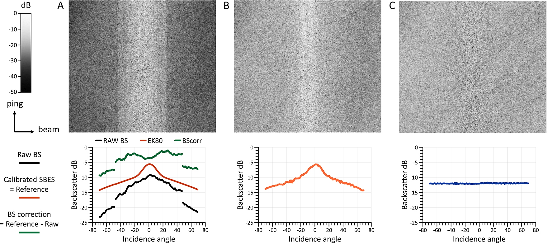
For each angle of incidence, the calibration corrections to be applied to the MBES BS data correspond to the differences between the MBES measurements and the reference mean ARC from the calibrated SBES EK80. Beam pattern correction is included in the BS correction values relative to the mean reference ARC (Fig. 9a). All BS measurements involved are taken at the same frequency and strictly within the Kwinte calculation sub area. The BS calibrated and corrected for the beam pattern keeps the BS angular dependence, which is related to the seabed’s characteristics (Fig. 9b). It can be used for analyzing and modeling the angular response across different habitats. The calibration ensures the intercomparability of BS from different MBESs acquired with similar frequencies. A flattening correction is then applied to the calibrated BS corrected for the beam pattern. This correction keeps the calibrated average level of the BS consistent over the entire surveyed area. With no further artefacts, the resulting calibrated BS, corrected for the beam pattern and for the angular response, can be used as a basis for acoustic classification and seabed habitat mapping (Fig. 9c).
As part of the monitoring of the environmental impact of sand extraction in the Belgian part of the North Sea, MBES measurements are systematically carried out at 300 kHz. The stability of the Kwinte area and the reference mean ARC from the EK80 calibrated at 300 kHz provide a reliable basis for cross-calibrating all the MBES BS data from different shipborne systems. However, a systematic measurement of the MBES BS of the Kwinte sub area during each survey campaign is necessary to take into account the instrumental variation of the BS linked to fluctuations in seawater temperature.
This cross-calibration method has been successfully applied to BS time series from sand extraction monitoring zones. It facilitates the intercomparison of BS data from different MBESs, corrects for instrumental discrepancies and ensures the integrity of the BS data over the long term (Roche et al., 2025). An example of cross calibration of BS data from one monitoring area is presented in Figure 10. Data regularly acquired from the monitoring zone located on the sandbank to the north of the Kwinte area have been systematically calibrated using the Kwinte subarea survey that is closest in seawater temperature and in time (Fig. 10a). Calibrated and beam pattern corrected BS data can be used to extract angular responses in areas of interest for detailed analysis of acoustic-sediment relationships (Fig. 10b). Mean BS level in the ±[30°,50°] angular range is a reliable proxy for assessing changes in sediment cover. Cross-calibration allows data from different MBES to be considered within the same time series (Fig. 10c).
Currently, cross-calibration is carried out during post-processing, but future advances could allow real-time corrections to be integrated into MBES acquisition systems.
5 Get started yourself and contribute to the project
If you undertake a new survey in the Kwinte reference area, please inform VH4 and COPCO5. The recommended procedure is described on our website6. It takes about two to three hours to survey the area. We ask to acquire the data with online RTK (Real Time Kinematic) for positioning and we ask to refer the data to LAT (Lowest Astronomical Tide). VH can assist with this, if needed.
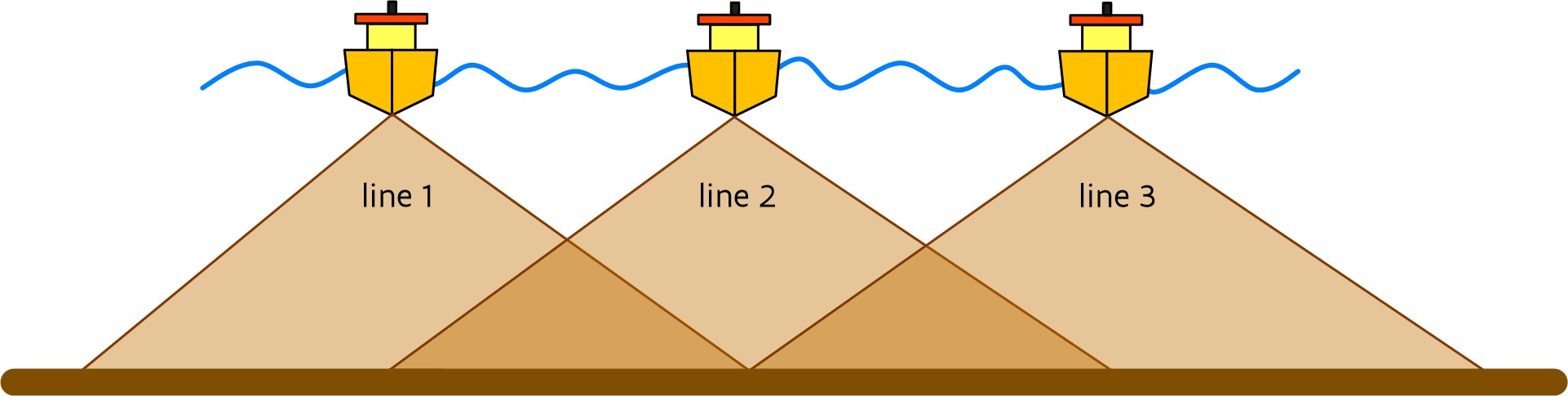
A typical survey consists of a set of parallel lines with 200 % overlap (Fig. 11). The aim is to achieve a filled 1 m × 1 m grid after processing. It is important to survey with RTK accuracy or similar and to refer towards Lowest Astronomical tide (LAT).
Once the survey has been carried out and has been processed, please send the complete project to VH and COPCO. All participants will receive feedback on their survey. The data in the control area will be checked towards the IHO Exclusive Order for bathymetry and compared with the model. The delivered datasets will also be checked on artifacts resulting from timing, motion, sound velocity or other problems. If the bathymetric survey is accepted, the participant will be asked for approval to incorporate the results in the mean reference model calculation. If the participant agrees, info regarding the approved survey will be published on the website. A remark here: an accepted survey over the Kwinte area does not guarantee that all subsequent surveys with the vessel in other areas are also accepted. This is not the responsibility of the project partners.
For each accepted survey an extensive report is prepared with a description of the results and with reference towards the mean model.
6 Conclusion
The Kwinte reference area is a key site for monitoring the quality of bathymetry and BS measurements by MBES. Its stability, sediment composition and protection from seabed disturbance make it an ideal site for ensuring reliable and comparable bathymetry and BS data from MBES systems. Long-term monitoring of the area has confirmed its value as a reliable natural reference site.
Its accessibility and integration into the marine spatial plan reinforces its importance. A policy of free access encourages public and private entities to use it for hydrographic surveys. The Kwinte area’s accessibility, along with VH’s contractual requirement for its use in hydrographic data quality control, has led to a significant collection of bathymetric data from various MBES operated on Belgian and Dutch vessels.
The stability of the bathymetry is a major advantage of the Kwinte area. Decades of surveys reveal minimal changes in the elevation of the seabed, allowing for an accurate assessment of instrument performance and repeatability. The consistency of these results between the different MBES configurations makes the Kwinte area an essential reference for the validation of bathymetric data, the detection of biases and the refinement of measurement techniques in order to meet international hydrographic standards.
As a stable BS reference, the Kwinte area plays a crucial role in ensuring the accuracy, the consistency, the repeatability and the comparability of MBES BS measurements, particularly in the context of seafloor scientific monitoring programs. Long-term BS measurements done with the same MBES demonstrate a remarkable BS level consistency without any trend over more than a decade. This stability ensures that any variations observed in the BS levels can be confidently attributed to instrumental bias rather than real sediment changes. In addition, the reference angular response curves (ARC) derived from calibrated single beam echo sounder (SBES) measurements provide a robust framework for cross-calibrating MBES BS data. The cross-calibration methodology allows the instrumental variations associated with seawater temperature to be taken into account. By systematically surveying the Kwinte area during each monitoring campaign, a retrospective calibration of the BS measurements ensures the inter-compatibility of BS data from different MBES. This approach has been successfully applied to sand extraction monitoring areas, allowing the integration of BS data from different MBES into a single coherent time series, thus improving the reliability of seafloor evolution studies.
Currently used for post-processing, this methodology could, in the future, ideally be integrated into MBES acquisition systems to allow real-time calibration.
As research progresses, the Kwinte reference area will continue to serve as a reference for high quality, reproducible and scientifically rigorous MBES bathymetric and BS data, reinforcing its essential role in validating MBES data used in hydrography, marine habitat monitoring and sediment dynamics studies.
In practice, the definition, initial assessment, monitoring, and management of a reference area fall under the responsibility of a specific organization or group of stakeholders. However, establishing collectively a network of calibration zones would enhance accessibility for all relevant actors in the field, enabling calibration and repeatability checks of bathymetry and BS for any MBES used in international campaigns and research and monitoring initiatives. Mandating that contractors involved in hydrographic survey, monitoring and mapping programs regularly survey reference areas to calibrate their sonar systems would convey a strong and positive message to the hydrographic and scientific communities. In particular for the BS users community, for which no BS quality scale has yet been established, this requirement would underscore the significance of quantitative BS signal acquisition and processing, marking a significant advancement in this research field.
Acknowledgements
The authors wish to thank their colleagues at VH and COPCO who participated in the project. We would like to warmly thank our colleagues Ridha Fezzani, Arnaud Gaillot and Laurent Berger for their work in calibrating, acquiring, analyzing and producing the Kwinte area BS reference angular responses. The authors also thank the participating institutes and companies and the crews of the Hydrographic and Research Vessels involved in acquiring the data presented in this contribution.
References
Deleu, S. and Roche, M. (2020). KWINTE, a Dedicated Quality Control Area in the North Sea with Stable Seabed. Reference Area for Multibeam Bathymetry and Backscatter. Hydro international, 1, pp. 18–20.
Eleftherakis, D., Berger, L., Le Bouffant, N., Pacault, A., Augustin, J. M. and Lurton, X. (2018). Backscatter calibration of high-frequency multibeam echosounder using a reference single-beam system, on natural seafloor. Marine Geophysical Research, 39, pp. 55–73.
Fezzani, R. and Berger, L. (2023). Creation of a reference area for backscatter calibration of shallow and medium depth multibeam sounders. Ifremer internal report, ASTI-2023-300, 24.
IHO (2022). Standards for Hydrographic Surveys (ed. 6.1). IHO Special Publication S-44, International Hydrographic Organization, Monaco. https://iho.int/uploads/user/pubs/standards/s-44/S-44_Edition_6.1.0.pdf (accessed 18 March 2025).
Lurton, X., Lamarche, G., Brown, C., Lucieer, V., Rice, G., Schimel, A. and Weber, T. (2015). Backscatter measurements by seafloor-mapping sonars. Guidelines and recommendations. doi:10.5281/zenodo.10089261 200
Roche, M., Degrendele, K., Vrignaud, C., Loyer, S., Le Bas, T., Augustin, J. M. and Lurton, X. (2018). Control of the repeatability of high frequency multibeam echosounder backscatter by using natural reference areas. Marine Geophysical Research, 39, pp. 89–104.
Roche, M., Birkenes Lønmo, T. I., Fezzani, R., Berger, L., Deleu, S., Bisquay, H., Gaillot, A., Vanparys, K., Vercaemst, J., Degrendele, K., Barette, F., Fonseca, L., Verstraeten, J., Jensen, K., Echholt Nilsen, K., Montereale Gavazzi, G., Lurton, X., Augustin, J.-M. (2025). Instrumental temperature-dependence of backscatter measurements by multibeam echosounder: findings and implications. Frontiers in Remote Sensing, Special Issue Multibeam Echosounder Backscatter: Advances and Applications, accepted 8 May 2025.
- https://www.health.belgium.be/en/environment/seas-oceans-and-antarctica/north-sea-and-oceans/marine-spatial-plan (accessed 15 March 2025).
- https://www.agentschapmdk.be/en/flemish-hydrography (accessed 15 March 2025).
- https://economie.fgov.be/en/themes/enterprises/offshore-sand-and-gravel (accessed 15 March 2025).
- Please send an email at samuel.deleu@mow.vlaanderen.be (subject Survey Kwinte reference area).
- Please send an email at marc.roche@economie.fgov.be (subject Survey Kwinte reference area).
- Kwinte reference area: https://www.agentschapmdk.be/en/acoustic-reference-area-kwinte (accessed 18 March 2025).