


Abstract
1 Introduction
Documenting the seabed of specific areas or the ocean, in general, is the foundation of the oceanography fields and the hydrospatial domain (Hains et al., 2022). This scientific field pertains to the introductory study of ocean features, including currents, tides, and waves. It is crucial in applications ranging from the safety of navigation, management of sea resources, monitoring the effects of the sea on marine structures and ecosystems, and assessment of climate change. For the last ten years, new technologies have risen that have brought bathymetric science to another level where surveying the ocean floor becomes precise and detailed.
As said earlier, quality bathymetry data is crucial. From enabling the international maritime business to promoting sustainable fisheries, these data underpin significant determinations in global and local settings. Furthermore, bathymetry is critical to finding viable solutions to even the most burning issues related to climate change because it supplies the primary baseline information required for resolving issues associated with sea-level rise, shoreline shifts, and the effects of storms.
Over the past ten years, significant advances have been achieved concerning new advanced technologies, which include multibeam sonars, satellite-derived bathymetry, and laser imaging detection and ranging (LiDAR). Compartmentalized systems such as autonomous underwater vehicles (AUVs) and unmanned surface vehicles (USVs) have expanded the capabilities of bathymetric and hydrospatial surveys to complex and sometimes dangerous areas. In addition, international projects like the Nippon Foundation-GEBCO (General Bathymetric Chart of the Oceans), Seabed 2030 Project have advanced calls to focus on the worldwide goal of mapping all the world’s oceans.
Notwithstanding these developments, some issues have cropped up in organizations. The expensive venture in sea drilling, lack of information on a significant portion of the ocean, and accessibility and technology constraints in developed countries demonstrate that the field is sustainable for further development. This paper reviews the developments associated with ocean bathymetry from 2015 to 2025, discusses the contemporary issues that continue to be experienced, and looks ahead to the future of bathymetry based on advances in technology and collaboration for fair sharing of valuable information.
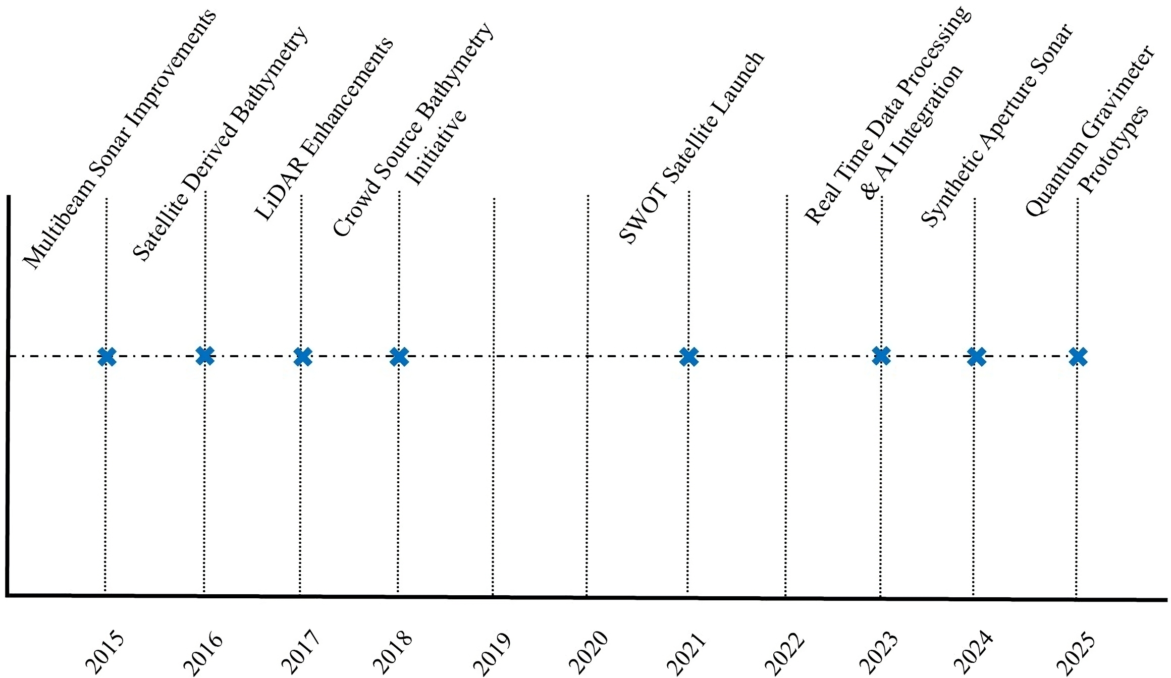
2 Technological advances in ocean bathymetry
2.1 Multibeam sonar systems
Multibeam sonar technology has evolved with advancements that enable high-resolution deep and shallow water mapping. Improvements, especially in signal processing and Data fusion techniques, have made these systems more accurate and efficient (National Research Council, 2015; IHO, 2021b). Current multibeam systems have a wider band and real-time viewing instruments, making it easier to generate accurate terrain during surveys.
2.2 Satellite-derived bathymetry
Satellite-derived bathymetry (SDB) is highly cost-effective technique for mapping coastal and shallow inland waters where water clarity allows. Methods based on points like Real Time (RT) and Direct LiDAR Waveform (DLW) LiDAR have enhanced SDB precision (Ouellette et al., 2023; Zhang et al., 2024). The International Hydrographic Organization (IHO) has been enthusiastic about SDB applications, launching practices like the Ocean Decade Bathymetry Data Sharing Guideline (UNESCO-IOC, 2024). Additional improvements in imagery resolution, especially in cloud penetrations, and more frequent satellite revisit rates have strengthened SDB.
2.3 Autonomous vehicles and remote sensing
Using the autonomous underwater and unmanned surface vehicles have opened up the bathymetric surveys in remote and dangerous areas. Modern AUVs belong to vessels capable of high-resolution seafloor mapping in compliance with standards set by the IHO (Kyoko, 2024; Reithmeier, 2024). New accomplishments include swarm robotics, where several AUVs work jointly, another improvement in navigation, which increases data accuracy when operating in a deep-sea area.
2.4 LiDAR technologies
New airborne and topo-bathymetric LiDAR systems developments improved new shallow nearshore and shallow water mapping where water clarity allows. These cost-effective technologies offer hi-resolution data and are especially useful in locations where sonometer techniques pose challenges (Corcoran & Parrish, 2023; Ekelund, 2023). Newer technologies are green-wavelength, which sees deeper through water columns, and multispectral LiDAR, which acquires other ecological and geological data.
2.5 Crowdsourced bathymetry
Crowdsourced bathymetry (CSB) has, therefore, risen to popularity as one of the economical ways of enhancing global data acquisition. Commercial and recreational vessels can contribute to the bathymetric data under the IHO’s CSB initiative (IHO, 2024b; Goddard, 2025). Much progress has been made in integrating mobile apps and onboard data logging systems so that nontechnical people can easily acquire and share good bathymetry data. The question of data quality and data liability remains an issue. However, CSB could be adapted as a tool for reconnaissance, hazard detection and temporary navigational warnings (Hains et al., 2024).
2.6 SWOT satellite missions
Radar interferometry from Satellite Surface Water and Ocean Topography (SWOT) has introduced new techniques in seafloor mapping where water clarity allows. The operation of these missions gives the global coverage and advances the knowledge of major oceanographic characteristics (Fu et al., 2024). Subsequent versions of SWOT are likely to enhance radar altimeters having better resolution and accuracy.
2.7 Synthetic aperture sonar
This work introduces a new technology known as synthetic aperture sonar (SAS), which is seen as a capability-enhancing tool for high-definition seafloor mapping where water clarity allows. SAS systems involve sophisticated signal analysis to capture clear pictures of the seabed, particularly in deep, dark waters. They are most helpful in recognizing objects and topographical formations and are essential for geological and industry use (Kyoko, 2024).
2.8 Real-time data processing and machine learning
With the help of machine learning algorithms, the integration of real-time data processing has challenged the way bathymetric data are analyzed. These technologies allow for automated detection of features, erroneous data correction, and automated modelling, saving time in post-survey data processing (Wu et al., 2021; GEBCO, 2025a).
2.9 Fiber optic sensing for seafloor mapping
In recent years, new developments in fiber optic sensing have demonstrated capability in seafloor mapping. One such system uses distributed acoustic sensing (DAS) to detect seismic and acoustic signals over large distances, which can carry out large-scale bathymetry surveys at a cost (Cheng et al., 2021).
2.10 Deep learning for feature extraction
New learning algorithms have further enriched the possibility of feature extraction from bathymetry data sets. Sparker and boomer can locate underwater structures, sediment types and ecological habitats more efficiently than conventional techniques (Corcoran & Parrish, 2023).
2.11 Hybrid systems
Multimodal solutions integrating sonar, LiDAR, and optical imaging in a single framework are frequently used for successful and efficient surveys in various underwater terrains. These systems take advantage of two or more technologies to give a better insight into the conditions on the ocean floor (Kyoko, 2024). Details of technologies utilized for mapping is mentioned in Table 1.

3 Global initiatives and collaborative efforts
3.1 The Nippon Foundation-GEBCO, Seabed 2030 project
The Global Exploration of the Continuous and Ongoing Processes of the Earth, also known as Seabed 2030, is an initiative led by GEBCO and supported by the Nippon Foundation. This goal is being completed through the cooperation efforts of governments, commercial organizations, research institutes, technologies and CSB (Jakobsson et al., 2024; GEBCO, 2025a).
3.2 The International Hydrographic Review contributions
In addition, The International Hydrographic Review (IHR) has been instrumental in reporting developments and research findings in bathymetry. IHR articles have pointed to different means to increase knowledge and understanding of the roles of machine learning in data analysis and the applicability of SDB methods at large (Ferreira et al., 2022; Ouellette et al., 2023).
3.3 GEBCO training program
The Training Program of General Bathymetric Chart of the Oceans (GEBCO) aims to strengthen the bathymetry study by building up the qualified human resources of various countries and areas. This effort has resulted in a colossal improvement in seafloor mapping and data integration around the globe (GEBCO, 2025b).
3.4 IHO capacity building initiative
The main objective of the IHO Capacity Building Initiative is to enhance the technical and institutional capacity of under-resourced nations. This program improves developing nations’ capacity to engage in bathymetric efforts (IHO, 2023) through capacity building, knowledge transfer and funding support.
3.5 The United Nations Ocean Decade bathymetry data sharing guidelines
As per the Ocean Decade initiative, the IHO has formulated some principles to help different countries share data fairly. Recognizing bathymetry as a global public good, these guidelines are intended to reduce restrictions to this fundamental geospatial dataset and promote global cooperation and openness (UNESCO-IOC, 2024).
3.6 Arctic bathymetric mapping collaboration
Cooperative work in the Arctic, like the International Bathymetric Chart of the Arctic Ocean (IBCAO), has made it possible to map areas that were not mapped before. Such projects are essential for assessing the effects of climate change in Polar Regions (Jakobsson et al., 2024).
3.7 Regional partnerships for SDB and CSB
Organizations in the Caribbean and Pacific have collaborated to advance the use of satellite-derived bathymetry and crowdsourced bathymetry approaches to enhance coastal protection. Such efforts point out the applicability of regional organizations to ending localized bathymetric deficits (Dery, 2024; Thomas et al., 2021). Key initiatives are mentioned in Table 2.

4 Supporting under-resourced nations
4.1 Challenges faced by under-resourced nations
Currently, there are several problems with using the most sophisticated bathymetric resources for many countries, especially for the states of the South and Small Island Developing States. These challenges include high costs, limited technical skills, and limited access to data-sharing networks (Hariram, 2024; GEBCO, 2025b). Most developing countries find it very challenging to fund and conduct large-scale bathymetric surveys. Landlocked countries face difficulties acquiring raw ocean information through various means influencing their interests. Because of technical limitations and insufficient funding, many coastal nations have failed to create coastal mapping initiatives properly. Therefore, some important areas are still not protected against climatic factors, and maritime areas are not secure.
4.2 Capacity-Building Initiatives
For many underdeveloped countries, capacity-building programs are indispensable. The IHO and GEBCO have used training workshops and scholarships to promote human capital by developing local professionals with expertise in hydrography and bathymetry (IHO, 2023; Midford & Østhagen, 2024). Some of the training, including the Nippon Foundation-GEBCO Training Project, has been useful in preparing the participants for the mapping tasks worldwide. For instance, Ghana has benefited from such endeavours; currently, the trained personnel are accruing the upgrade of the bathymetric survey along the coast of Ghana.
4.3 Collaborative data sharing
Understanding and addressing these lapses could be achievable by pulling the plugs in our technological releases that neglect the modern means of making data open access to everyone. The IHO Crowdsourced Bathymetry Initiative and Ocean Decade Guidelines are transparent about using bathymetric data openly for the benefit of all countries (IHO, 2024b; UNESCO-IOC, 2024). An example of the above model is EMODnet (European Marine Observation and Data Network), which works to improve data sharing (IHO, 2024a).
4.4 Financial support mechanisms
Access to international funding sources and cooperation may contribute to the funds required to conduct bathymetric surveys in the least-developed countries. For instance, the World Bank’s Blue Economy program has helped finance coast mapping and resilience investment in Mozambique and Bangladesh. They have also facilitated the movement of technology and skills between developed and developing countries (National Research Council, 2015; Jakobsson et al., 2024). Ghana has also partnered with organizations such as the African Union and UNECA (United Nations Economic Commission for Africa) to take the initial form of the development of more contemporary hydrographic offices.
4.5 Leveraging low-cost technologies
Crowdsourced bathymetry and satellite-derived bathymetry are also possible low-cost solutions for Low- and Middle-Income Countries (LMICs). These approaches minimize the use of costly multibeam sonar systems and large survey vessels (Corcoran & Parrish, 2023; Ekelund, 2023). Ghana has recently adopted satellite-based techniques for mapping important coastal areas susceptible to flood and erosion.
4.6 Case Studies
- Fiji’s Bathymetric Mapping Initiative: Fiji used international collaborations and crowdsourced bathymetry to enhance its coastal mapping capabilities (IHO, 2024b; Goddard, 2025).
- The Caribbean Region: Support Regional partnerships facilitated scaling of SDB projects utilizing deep learning and cloud technologies improving coastal resilience (IHO, 2024a).
- The African Region: Evaluation of EU international goals reveals that hydrographic capacity development for Africa can provide important backing for port infrastructure expansion and blue economic growth, sustainable fisheries promotion, and stronger maritime security (IHO, 2024a).
- Ghana’s Coastal Resilience Program: To mitigate vulnerabilities to climate change and maritime security, Ghana has undertaken projects to improve coastal mapping infrastructure using international aid and satellite-derived bathymetry (Dery, 2024).
5 Persistent challenges
5.1 Data gaps in deep ocean mapping
Even with all technological advances, large swaths of the deep ocean remain unmapped. Due to the high cost and logistical complexity of deep-sea expeditions, progress is hindered (IHO, 2023; Hariram, 2024). Furthermore, the Southern Ocean and areas around the Pacific Ring of Fire pose significant problems because of extreme depths, remoteness and harsh environmental conditions. Unfortunately, these gaps are compounded by the lack of global funding for deep-sea exploration, which leaves many critical ecosystems and geological features unknown (National Research Council, 2015).
5.2 Integration and standardization
Standardization and quality control have been challenging in integrating different datasets from multibeam sonar, SDB, and AUVs. Global data sharing is complicated without uniform data formats (Hankin et al., 2010; IHO, 2023). For example, large-scale mapping projects using these data may be prone to errors due to inconsistent data sets generated by different nations or institutions. To address these discrepancies, we need to develop international standards and automated means to harmonize data.
5.3 Environmental and geopolitical barriers
Some surveys are only feasible within a narrow environmental range, for example, adverse weather, strong currents or rough seas. Meanwhile, access to exclusive economic zones (EEZs) is also restricted by geopolitical conditions, preventing complete mapping. Territorial boundary disputes and restrictions on data collection in sensitive areas continue to hold up progress (National Research Council, 2015; Midford & Østhagen, 2024). The list of current geopolitical barriers and its impact on mapping is mentioned in Table 3.

5.4 Limited access to advanced technologies
High costs, special training requirements, or unavailability limit the use of advanced bathymetric technologies in many under-resourced nations. However, this limitation maintains the divide in the global bathymetric data, with significant discrepancies in sub-Saharan Africa and parts of Southeast Asia (Hariram, 2024). In addition, these countries face further hurdles due to a lack of infrastructure for processing and keeping large datasets.
5.5 Data privacy and security concerns
While crowdsourced and shared bathymetric data have been increasingly approaching utility for more and more applications worldwide, we are seeing growing concerns with data privacy and security. For example, sensitive coastal and underwater infrastructure data could be vulnerable to misuse or cyber-attacks in geopolitically sensitive regions. To handle them, it is important to develop robust sharing systems of data and security structures (Trice et al., 2021).
5.6 Resource and capacity constraints in bathymetric science
Large-scale bathymetric surveys are associated with high costs, often resulting in uneven resource allocation in which wealthier nations can afford to map areas of present interest. As a result, much of the world, especially in the Global South, remains insufficiently mapped and studied. Equitable progress in bathymetric science (Jakobsson et al., 2024) requires collaborative funding mechanisms and international partnerships.
6 Future horizons
6.1 Artificial intelligence, machine learning and deep learning
AI, machine learning and deep learning will revolutionize automated feature detection and error reduction of bathymetric data. Such technologies will improve data accuracy and shorten processing time (Ferreira et al., 2022; Long et al., 2023). For example, machine learning algorithms are taught to recognize certain seafloor features like underwater ridges and fault lines from large datasets. Additionally, AI-powered automation will facilitate cross-referencing diverse data sets, such as sonar, satellite and LiDAR data, for seamless integration.
6.2 Advances in satellite technology
With improvements in the resolution and spectral capabilities of new satellites to be launched, SDB will be expanded. Given missions of SWOT satellites, such as those of Fu et al. (2024) and Araujo & Hedley (2023), seafloor mapping applications are promising. Satellite technologies on the horizon will enhance polar coverage and other areas with sparse coverage due to high cloud cover, expanding the existing coverage of optical and radar-based systems. Hyperspectral imaging and nanosatellite constellations are innovations that will improve data resolution and accessibility for smaller nations and research institutions.
6.3 Expanded use of AUVs and USVs
Multibeam sonar, LiDAR, and optical imaging are hybrid sensors that will find their way onto future AUVs and USVs. These systems will enable comprehensive mapping in complex underwater environments (Constantinoiu et al., 2023; Kyoko, 2024). Their operation in remote areas for extended periods will require advances in autonomous navigation and energy efficiency and will reduce the need for crewed missions. Modular designs will also allow for rapid customization of AUVs and USVs to meet the needs of particular research objectives from deep sea geology to biodiversity assessment in the hydrospatial domain.
6.4 Open data and collaborative platforms
Multinational web-based tools and data releases will stimulate international projects to undertake bathymetric studies. e.g. the IHO collaborates with the GEBCO Strategy 2023–2030 (IHO, 2021a). This white paper also details how data sharing will transition to future platforms based on cloud computing and blockchain technology to enable open and direct data sharing between buyers, suppliers and third parties. This will support data-sharing platforms that facilitate global collaboration and data integrity of ocean bathymetry safely and transparently. The process, explanation and procedure of blockchain technology adoption, are given in Table 4. EMODnet and NOAA’s Digital Coast improve engagement by developing interfaces with more up-to-date data feeds to the broader public.

6.5 Emerging sensor technologies
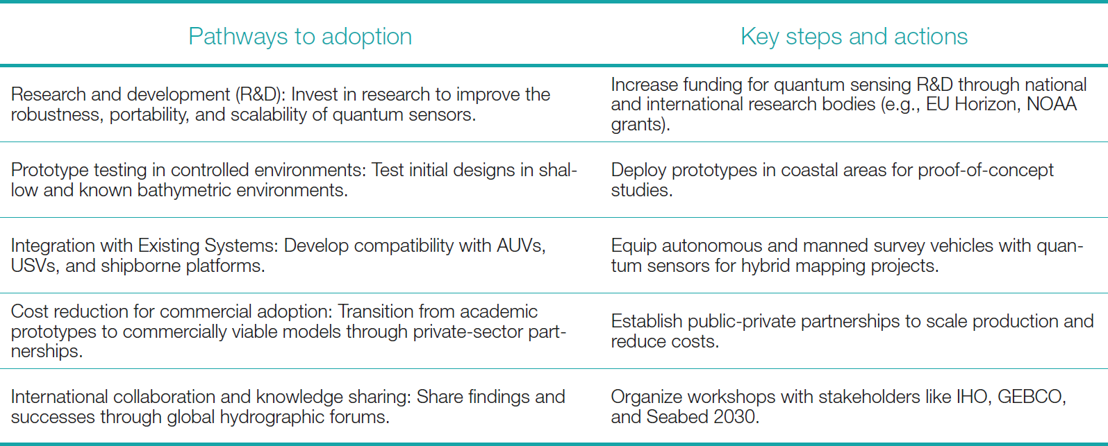
Bathymetric and hydrospatial data collection is poised to be revolutionized by recent innovations in sensor technology, quantum gravimeters and distributed acoustic sensing. For example, quantum gravimeters can detect the minutest differences in gravitational fields and tell us much about seafloor structure (Ekelund, 2023). Quantum gravimeters are revolutionary tools which offer the possibility of making ultra-sensitive measurements of gravitational fields to yield high-resolution seafloor mapping. However, these sensors, developed from these capabilities and advancing fiber optic technologies, will be taken to previously closed-off regions beneath ice shelves and sediments. The pathway to adoption of quantum sensors is mentioned in Table 5.
6.6 Integration of citizen hydrospatial science
The role of the broader citizen science in expanding data coverage will be key to the expanded data collection effort. On the one hand, existing datasets will be significantly augmented through programs encouraging recreational boaters, fishers, and coastal communities to contribute geospatial data (IHO, 2024b; Goddard, 2025;) in the hydrospatial domain. In order to have widespread participation and data validation, emerging tools like mobile applications with user-friendly interfaces will be utilized.
7 Conclusion
Over the past decade, ocean bathymetry has received transformative advances in technology, global collaboration, and science. With advanced seafloor mapping technologies such as Multibeam sonar, LiDAR, and Satellite-Derived Bathymetry, the scale and precision of mapping have greatly increased, propelling us to map all of the world’s oceans. Concurrently, autonomous vehicles and advanced sensor systems have extended human reach into deep marine environments, from the most remote and hostile to the deepest parts of the ocean, providing unique glimpses into deep-sea ecosystems and geological processes.
However, there is much left to be worked on. Ocean regions far from landmasses have data gaps that need more global funding and logistical support. Geopolitical disputes, environmental constraints, and gaps in technological access are among additional barriers that further hinder the completion of a fully mapped seafloor. Overcoming these blockages will depend heavily on active international collaboration, fair resource distribution, and comprehensive capacity-building programs aimed at under-resourced nations.
The field promises to be transformed by nimble technologies such as artificial intelligence, quantum sensors and blockchain-enabled data-sharing platforms. The improvements in oceanographic and hydrospatial data accuracy, uncertainty and accessibility will spur progress in linked multidisciplinary areas such as climate science, maritime safety, marine and hydrospatial resource management. The Seabed 2030 Project and GEBCO’s training programs represent best practices in bringing together collective action to achieve scientific goals inclusively and equitably.
When completion of the Gulf (referred to as a metaphor for seabed mapping) is realized, the future of ocean bathymetry, unveiling the mysteries of the seafloor, relies on the future marriage of technology and collaboration to enable the benefits of such knowledge to be universally enjoyed. Bathymetric and hydrospatial sciences is yet another knowledge gap that will be bridged, and global communities will be empowered by better understanding and assisting in the preservation of the health of our oceans and for continued sustainable use of our oceans for many generations unless it is stopped.
Learning algorithms for hydrographic mapping, the accuracy of these depth measurements remains inferior to that achieved using acoustic equipment (Saeidi et al., 2023; Pike et al., 2019). Among acoustic devices, the multi-beam echo sounder (MBES) has gained significant attention in national ports over the last decade. The volume of data captured by MBES is exponentially higher than that of single-beam echo sounders (SBES), providing continuous seabed coverage, which accelerates depth measurement and reduces field operation times (Costa et al., 2009).
References
Araujo, A. A., Hedley, N. (2023). Bathymetric data visualization – A review of current methods, practices and emerging interface opportunities. The International Hydrographic Review, 29(2), pp. 150–163. https://doi.org/10.58440/ihr-29-2-a29
Cheng, F., Chi, B., Lindsey, N. J., Dawe, T. C. and Ajo-Franklin, J. B. (2021). Utilizing distributed acoustic sensing and ocean bottom fiber optic cables for submarine structural characterization. Scientific reports, 11(1), 5613.
Constantinoiu, L.-F., Bernardino, M. and Rusu, E. (2023). Autonomous Shallow Water Hydrographic Survey Using a Proto-Type USV. Journal of Marine Science and Engineering, 11(4), 799.
Corcoran, F. and Parrish, C. E. (2023). DORSL-FIN: A Self-supervised Neural Network for Recovering Missing Bathymetry from ICESat-2. Photogrammetric Engineering & Remote Sensing, 89(9), 561-575.
Dery, P. J. (2024). West Africa Coastal Areas Resilience Investment Project 2. World Bank Group. https://projects.worldbank.org/en/projects-operations/procurement-detail/OP00305223 (accessed 13 August 2024).
Ekelund, A. (2023). Rising tides: exploring the expanding horizons of bathymetric Lidar applications. Hydro International. https://www.hydro-international.com/content/article/rising-tides-exploring-the-expanding-horizons-of-bathymetric-lidar-applications (accessed 21 March 2025).
Ferreira, I. O., Andrade, L. C. d., Teixeira, V. G. and Santos, F. C. M. (2022). State of art of bathymetric surveys. Boletim de Ciências Geodésicas, 28(1), e2022002.
Fu, L. L., Pavelsky, T., Cretaux, J. F., Morrow, R., Farrar, J. T., Vaze, P., Sengenes, P., Vinogradova-Shiffer, N., Sylvestre-Baron, A. and Picot, N. (2024). The surface water and ocean topography mission: A breakthrough in radar remote sensing of the ocean and land surface water. Geophysical Research Letters, 51(4), e2023GL107652.
GEBCO (2025a). General Bathymetric Chart of the Oceans (GEBCO). British Oceanographic Data Centre (BODC), National Oceanography Centre, United Kingdom. https://www.gebco.net/ (accessed 21 March 2025).
GEBCO (2025b). Nippon Foundation/GEBCO Training Program. British Oceanographic Data Centre (BODC), National Oceanography Centre, United Kingdom. https://www.gebco.net/training/ (accessed 21 March 2025).
Goddard, J. (2025). Meet the deep-sea explorer with a plan to map the whole ocean floor. The Times. https://www.thetimes.com/world/us-world/article/the-ocean-floor-map-crust-deep-sxg9s8mn9 (accessed 21 March 2025).
Hains, D., Keating, S. G., Rathnayake, C., Obura, V., Sharma, S. and Hall, S. (2024). Citizen Hydrospatial Sciences − To csB or not to csB, that is the question! The International Hydrographic Review, 30(1), pp. 162–170. https://doi.org/10.58440/ihr-30-1-n02
Hains, D., Schiller, L., Ponce, R., Bergmann, M., Cawthra, H. C., Cove, K., Echeverry, P., Gaunavou, L., Kim, S.-P., Lavagnino, A. C., Maschke, J., Mihailov, M. E., Obura, V., Oei, P., Pang, P. Y., Njanaseelan, G. P., Sharma, S. L. (2022). Hydrospatial – update and progress in the definition of this term. The International Hydrographic Review, 28, pp. 221–225. https://doi.org/10.58440/ihr-28-n14
Hankin, S., Bermudez, L., Blower, J. D., Blumenthal, B., Casey, K. S., Fornwall, M., Graybeal, J., Guralnick, R. P., Habermann, T. and Howlett, E. (2010). Data management for the ocean sciences—perspectives for the next decade. Proceedings of OceanObs, 9.
Hariram, V. (2024). Bathymetry, the Future Potential of Ocean Mapping, and the Seafloor Revolution. Available at SSRN 4977191.
IHO (2021a). Data Centre for Digital Bathymetry. International Hydrographic Organization, Monaco. https://iho.int/en/data-centre-for-digital-bathymetry (accessed 14 Januar 2025).
IHO (2021b). IHO Capacity Building Strategy (ed. 0.3). IHO Publication P-7, International Hydrographic Organization, Monaco. https://iho.int/uploads/user/Inter-Regional%20Coordination/CBSC/MISC/Capacity_Building_Strategy_2021_ver05.pdf
IHO (2023). Annual Report 2023 (ed. 1.0). International Hydrographic Organization, Monaco. https://iho.int/uploads/user/pubs/periodical/P7_2023_EN.pdf
IHO (2024a). IHO and EC cooperation in third countries – A proposal for hydrographic capacity development. IHO. International Hydrographic Organization, Monaco. https://iho.int/uploads/user/Inter-Regional%20Coordination/IENWG%20and%20EC%20-%20IHO%20Cooperation/IENWG14/IENWG14_2024_WT4.1A_EN_A%20proposal%20for%20hydrographic%20capacity%20development.pdf (accessed 14 Januar 2025).
IHO (2024b). IHO Crowdsourced Bathymetry Initiative. International Hydrographic Organization, Monaco. https://iho.int/en/iho-crowdsourced-bathymetry-initiative
Jakobsson, M., Mohammad, R., Karlsson, M., Salas-Romero, S., Vacek, F., Heinze, F., Bringensparr, C., Castro, C. F., Johnson, P. and Kinney, J. (2024). The International Bathymetric Chart of the Arctic Ocean Version 5.0. Scientific Data, 11(1), 1420.
Kyoko, O. (2024). Advances in Bathymetric Technology and Ocean Floor Geoscience. Ocean Policy Research Institute. https://www.spf.org/opri/en/newsletter/575_2.html (accessed 21 March 2025).
Long, J., Zhang, H. and Zhao, J. (2023). A comprehensive deep learning-based outlier removal method for multibeam bathymetric point cloud. IEEE Transactions on Geoscience and Remote Sensing, 61, pp. 1–22.
Midford, P. and Østhagen, A. (2024). The East China Sea: A Case of Ocean Geopolitics and Maritime Conflict. East Asia, pp. 1–32.
National Research Council (2015). Sea Change: 2015–2025 Decadal Survey of Ocean Sciences. Washington, DC: The National Academies Press. https://doi.org/10.17226/21655
Ouellette, G., Fargo, K., Charry, H. (2023). Satellite computed bathymetry assessment – Developing satellite LiDAR methods to enhance coastal bathymetry coverage. The International Hydrographic Review, 29(2), pp. 208–212. https://doi.org/10.58440/ihr-29-2-n05
Reithmeier, M., Laut, I., Gawehn, M., Kleih, C., Schneider von Deimling, J., Hartmann, K. (2024). Improving global coastal bathymetry from waves – Introducing scalable processing and post-processing workflows for 100 m resolution grids. The International Hydrographic Review, 30(2), pp. 30–43. https://doi.org/10.58440/ihr-30-2-a18
Thomas, N., Pertiwi, A. P., Traganos, D., Lagomasino, D., Poursanidis, D., Moreno, S. and Fatoyinbo, L. (2021). Space-borne cloud-native satellite-derived bathymetry (SDB) models using ICESat-2 and Sentinel-2. Geophysical Research Letters, 48(6), e2020GL092170.
Trice, A., Robbins, C., Philip, N. and Rumsey, M. (2021). Challenges and opportunities for ocean data to advance conservation and management. Ocean Conservancy: Washington, DC, USA.
UNESCO-IOC (2024). Ocean Decade Bathymetry Data Sharing Guideline. The Ocean Decade Series, 58. UNESCO, Paris.
Wu, Z., Mao, Z. and Shen, W. (2021). Integrating multiple datasets and machine learning algorithms for satellite-based bathymetry in seaports. Remote Sensing, 13(21), 4328.
Zhang, Q., Chai, H., Wang, M., Sun, S. and Liu, Y. (2024). Station-based SDB correction for GPS triple-frequency observations and its application on relative positioning. Measurement Science and Technology, 35(11), 116312.