


Abstract
1 Introduction
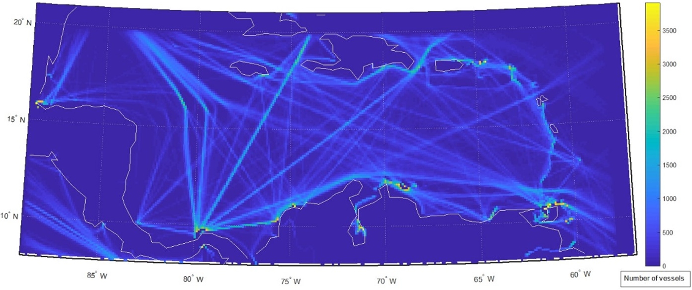
Maritime transportation is the backbone of global trade, accounting for 90 % of international commerce (IMO, 2025). It underpins economic development by facilitating foreign trade, industrial growth, and market accessibility. As global markets expand, demand for shipping continues to rise, driving advancements in vessel technology, port infrastructure, and navigational safety. While automation and intermodal logistics have improved operational efficiency, growing vessel traffic density has also increased the risks of collisions and congestion, particularly in heavily trafficked waterways. Ensuring safe and efficient maritime operations therefore requires comprehensive risk assessments and stricter regulatory measures. The Caribbean Sea serves as a vital maritime corridor, connecting major international and regional trade routes. Bordered by Venezuela, Colombia, Central America (including Panama), the Greater and Lesser Antilles, and the Atlantic Ocean, it ranks among the world’s busiest shipping regions. The Panama Canal enhances its global significance by facilitating interoceanic trade between the Pacific and Atlantic Oceans. The region is also a major hub for passenger vessels, hosting 50 % of the world’s cruise ships (Strauch, 2015). Key ports such as Freeport, Colón, and Port of Spain operate as transshipment hubs, supporting both regional and global commerce (Wilmsmeier & Sánchez, 2009). Fig. 1 illustrates the region’s high vessel traffic density, with 67,289 vessel tracks recorded in 2016 using Satellite Automatic Identification System (SAIS) data. Traffic is particularly concentrated near the Gulf of Paria and the Panama Canal, underscoring the complexity of maritime operations and associated safety concerns. While AIS coverage is not comprehensive, owing to limited equipment installation across vessel types and the possibility of manual transponder deactivation, it remains a critical tool for mapping vessel movements and delineating key shipping lanes. As maritime activity in the Caribbean increases, rigorous safety assessments and targeted risk mitigation strategies become increasingly significant. This study examines accident trends, vessel risk factors, and high-risk areas globally and within the Caribbean Sea, offering insights into navigational safety challenges. By analyzing spatial concentrations of maritime events, vessel types with high accident rate, and temporal risk patterns, the research aims to inform interventions that enhance safety and reduce maritime accident risks.
2 The importance of maritime safety and risk management
Maritime transport, while essential for global trade, carries inherent risks, making safety a critical priority. Beyond its economic importance, maritime safety is vital for environmental protection and societal well-being, as marine ecosystems are highly susceptible to pollution from oil spills, chemical leaks, and vessel groundings (Rodrigue, 2017). Ensuring robust safety practices safeguards human lives, marine biodiversity, and coastal communities, reinforcing the need for sustainable and resilient shipping operations. These maritime operations can be affected by a range of adverse events, broadly described as accidents or incidents. In this paper, an accident, also referred to as a marine casualty, denotes any event or sequence of events arising from vessel operations that results in serious consequences, such as loss of life, significant structural damage, grounding, collision, or major environmental harm (UN, EU, & ITF, 2019). An incident refers to an occurrence during vessel operations that does not produce such severe outcomes but poses a credible risk to the vessel, personnel, or the environment if not effectively managed (MAIB, 2019). Accidents ranging from collisions and oil spills to cargo losses can have severe economic, environmental, and human consequences. Beyond financial losses, these events contribute to long-term environmental degradation, biodiversity loss, and disruptions in trade flows (Goerlandt & Kujala, 2011). Notable disasters such as the MV Prestige sinking and the Deepwater Horizon oil spill highlight vulnerabilities in maritime operations and the critical need for stringent safety regulations. The maritime industry operates in an unpredictable environment affected by mechanical failures, human factors, extreme weather, and geopolitical tensions (Montewka et al., 2011). Human factors encompass not only individual actions but also procedural shortcomings, organizational culture, and operational conditions, recognizing that not all human contributions to accidents are the result of errors in the strict sense.
Analyzing maritime accident data is crucial for enhancing safety standards and improving operational protocols. Statistical analysis of past events helps identify patterns, assess risk factors, and develop predictive models to prevent future occurrences (Johansson & Molitor, 2011). Regulatory bodies like the International Maritime Organization (IMO) rely on accident data to enforce safety measures, including mandatory crew training, ship maintenance requirements, and advanced navigation technologies (Baldauf, 2016). Technological advancements, particularly artificial intelligence and data analytics, have further improved maritime traffic monitoring, anomaly detection, and early hazard warnings, enabling more effective risk management strategies (Fratila et al., 2021). A thorough examination of maritime accident databases is essential for uncovering critical causation factors, including human factors, mechanical failure, adverse weather conditions, and navigational hazards. Analyzing vessel records also provides insights into operational history, such as age, maintenance schedules, and compliance with safety regulations. Older vessels are often more prone to structural weaknesses, outdated safety systems, and mechanical breakdowns, increasing their risk of incidents (Maharaj, 2020). By systematically assessing these variables, regulatory bodies, ship operators, and policymakers can implement data-driven strategies to enhance maritime safety, improve vessel design standards, and enforce stricter maintenance protocols.
Long-term analysis of maritime accident trends enables researchers to identify recurring patterns, assess risk levels across shipping routes, and refine international safety regulations. A comprehensive review of accident data over the past two decades provides valuable insights into accident trends, causative factors, and areas for improvement (Smith & Cox, 2007). Understanding these statistical dynamics facilitates the implementation of effective safety regulations, technological innovations, and policy reforms to minimize risks. By prioritizing data-driven accident analysis, the maritime industry can foster a culture of safety, resilience, and sustainability, ensuring the continued growth and reliability of global shipping networks (Williams, 2015).
3 Literature review
Accurate and comprehensive maritime accident data is crucial for effective safety analysis and risk mitigation. The global analysis of maritime accidents reveals a complex landscape of risks influenced by human, technical, environmental, and organizational factors. Studies such as Akyuz & Celik (2023) highlight that cargo vessels are particularly vulnerable to collisions, while tankers face a higher risk of groundings, reinforcing the need for vessel-specific safety measures. Similarly, Zhou et al. (2020) emphasize that accident risks are not uniform across regions, with high-risk hotspots such as the South China Sea and the Gulf of Mexico necessitating tailored safety frameworks. A major challenge in maritime safety is the underreporting of accidents, which limits a comprehensive understanding of risk factors and hinders effective regulation (Psarros et al., 2010). Additionally, Liu et al. (2024) integrate environmental risk factors into maritime accident analysis, showing how severe weather and complex navigational routes significantly influence accident rates. Bowo et al. (2017) further highlight the role of human and organizational factors, identifying management practices, communication breakdowns, and machinery failures as primary contributors to maritime accidents. These findings stress the importance of crew training programs and improved management systems to enhance operational safety.
While global case studies provide essential insights, the Caribbean Sea remains under-researched despite its dense vessel traffic and strategic shipping routes. Existing studies, such as Maharaj (2020), explore AIS data for tracking vessel movements, but lack integration with detailed accident reports and modern analytical techniques, leaving gaps in understanding maritime risks. Historical analyses, such as Gomez Pretel et al. (2023) on the USS Kearsarge grounding, provide valuable perspectives but fail to address contemporary traffic patterns, regulatory changes, or technological advancements, further underscoring the need for updated, data-driven research. The global maritime safety framework is shaped by institutions such as the Marine Accident Investigators’ International Forum (MAIIF), Marine Accident Investigation Bureau (MAIB) and the European Maritime Safety Agency (EMSA), which investigate maritime accidents, identify causes, and promote industry-wide safety improvements. However, discrepancies in data collection, reporting criteria, and regulatory enforcement create challenges in developing standardized safety measures, especially in regions like the Caribbean, where multiple coastal and flag states interact.
The IMO plays a central role in maritime safety by promoting international conventions and regulatory frameworks. However, the slow adoption and enforcement of these measures delay critical legislative responses to major accidents. Flag state performance remains a significant factor in vessel safety, with organizations such as the International Chamber of Shipping (ICS), Maritime International Secretariat Services (MARISEC), and the International Transport Workers’ Federation (ITF) publishing annual performance indicators on treaty enforcement, maritime security, and seafarers’ welfare. These assessments reveal systemic strengths and weaknesses, reinforcing the need for stricter oversight and improved regulatory compliance to enhance global maritime safety.
In the Caribbean, the role of flag states becomes even more critical due to the dominance of open registries, particularly Panama and Liberia, which attract older vessels due to lenient registration policies. This practice compromises safety standards, increasing the likelihood of maritime accidents. The high vessel density and prevalence of open registry vessels place the Caribbean at heightened risk. This issue is further exacerbated by a lack of regional studies that integrate geostatistical methods, AIS data, and detailed accident reports. This study aims to bridge the research gap in the Caribbean Sea by conducting an in-depth geostatistical analysis of maritime accidents over the past two decades. By leveraging comprehensive datasets and advanced analytical methodologies, this research seeks to generate region-specific insights to support policymaking, improve navigational safety, and mitigate accident risks. Furthermore, this study complements global maritime safety efforts by offering data-driven recommendations tailored to the Caribbean’s operational challenges. Strengthening flag state oversight, improving data transparency, and integrating modern analytical techniques will be crucial for establishing a robust maritime safety framework in the region. By aligning global safety benchmarks with localized data, this research aims to enhance maritime risk assessments and support regulatory improvements. The findings from global case studies serve as valuable benchmarks, while the localized analysis addresses the specific challenges of the Caribbean. Ultimately, this study contributes to safer maritime operations, more effective accident prevention strategies, and a more sustainable shipping industry in one of the world’s most strategic maritime regions.
4 Data and methodology
The Global Integrated Shipping Information System (GISIS), maintained by the International Maritime Organization (IMO), serves as the primary data source for this study. GISIS compiles marine casualty and incident reports from national administrations, containing factual records and detailed investigative findings (IMO, 2012). The database provides key attributes such as incident date, vessel type, flag state, gross tonnage, spatial location, and causation factors, enabling the identification of accident trends and safety concerns. This study analyzed 6,260 maritime events reported globally between January 2002 and December 2021. While GISIS is a critical repository, it is affected by underreporting, resulting in the underestimation of maritime incidents (Psarros et al., 2010). Some records are supplemented by Automatic Identification System (AIS) transmissions, which provide vessel-specific details such as ship type, location, and casualty type. However, SOLAS regulations require AIS transponders only for vessels of 300 Gross Tonnage (GT) and above, excluding smaller vessels from mandatory reporting (IMO, 2012). Additional inconsistencies arise from missing vessel attributes, inaccurate navigational status, and human error in AIS data entry (Calder & Kurt, 2009).
To address these limitations, a comprehensive quality assessment was conducted, and a custom script was developed to retrieve missing static and voyage-related vessel information from online databases such as MarineTraffic and VesselFinder. By cross-referencing vessel attributes including ship type, gross tonnage, flag state, and year of construction with these sources, dataset completeness and reliability were substantially enhanced, improving the accuracy of maritime accident analyses and supporting evidence-based safety measures. For analytical clarity, the 145 distinct vessel types recorded in GISIS were reclassified into eleven broader categories, following the approach of Calder & Kurt (2009). This standardization reduced discrepancies between AIS data and supplementary vessel information, provided a structured view of shipping activity and global traffic density, and improved the consistency of maritime safety assessments. The analytical framework employed geostatistical techniques to map accident distribution and identify high-risk zones. Temporal analyses examined seasonal and daily patterns, while causation factor analysis determined the leading causes of events. Flag state performance was also assessed by examining accident frequency. This integrated methodology produced a robust understanding of maritime accident risks, with particular emphasis on the Caribbean region, and informed the development of targeted safety interventions.
5 Results
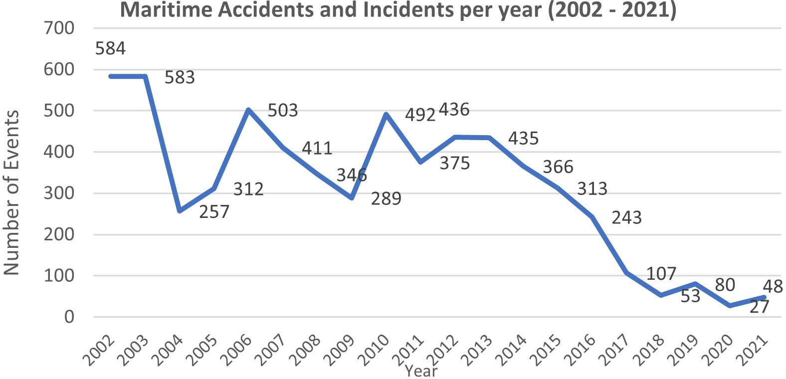
A comprehensive analysis of global maritime casualty and incident statistics over a 20-year period identified the primary factors contributing to maritime accidents. This timeframe was selected to include significant maritime disasters, such as the Prestige, Deep Water Horizon and Costa Concordia accidents, which catalysed major advancements in maritime safety regulations. The chronological timeline of regulatory changes presented in this study provides insight into the evolving landscape of maritime risk management. The analysis revealed that 2002 recorded the highest number of reported maritime events (584) with cargo vessels, container ships, tankers, fishing vessels, and passenger ships being the most frequently involved. Over time, the overall number of accidents exhibited a substantial decline (Fig. 2). Notably, 2004 and 2009 saw sharp reductions in accident frequency, aligning with the enforcement of the Safety of Life at Sea (SOLAS) Convention. These regulations mandated that all ships of 300 gross tonnage (GT) and above engaged in international voyages, cargo ships of 500 GT and above operating domestically, and all passenger vessels, regardless of size, be equipped with AIS transponders. The AIS regulation, which became fully effective on December 31, 2004, significantly improved vessel tracking and monitoring, enhancing navigational safety (IMO, 2012).
However, periods of increased accident frequency were observed in 2002, 2003, 2006, and 2010, coinciding with global fleet expansions (Gasparotti & Rusu, 2012). This suggests that while regulatory interventions have effectively reduced maritime accidents, fluctuations in fleet numbers and traffic density continue to influence accident trends. Understanding these dynamics is crucial for policymakers and industry stakeholders to further enhance maritime safety and develop adaptive risk management strategies.
5.1 Temporal variation of maritime accidents and incidents by vessel type
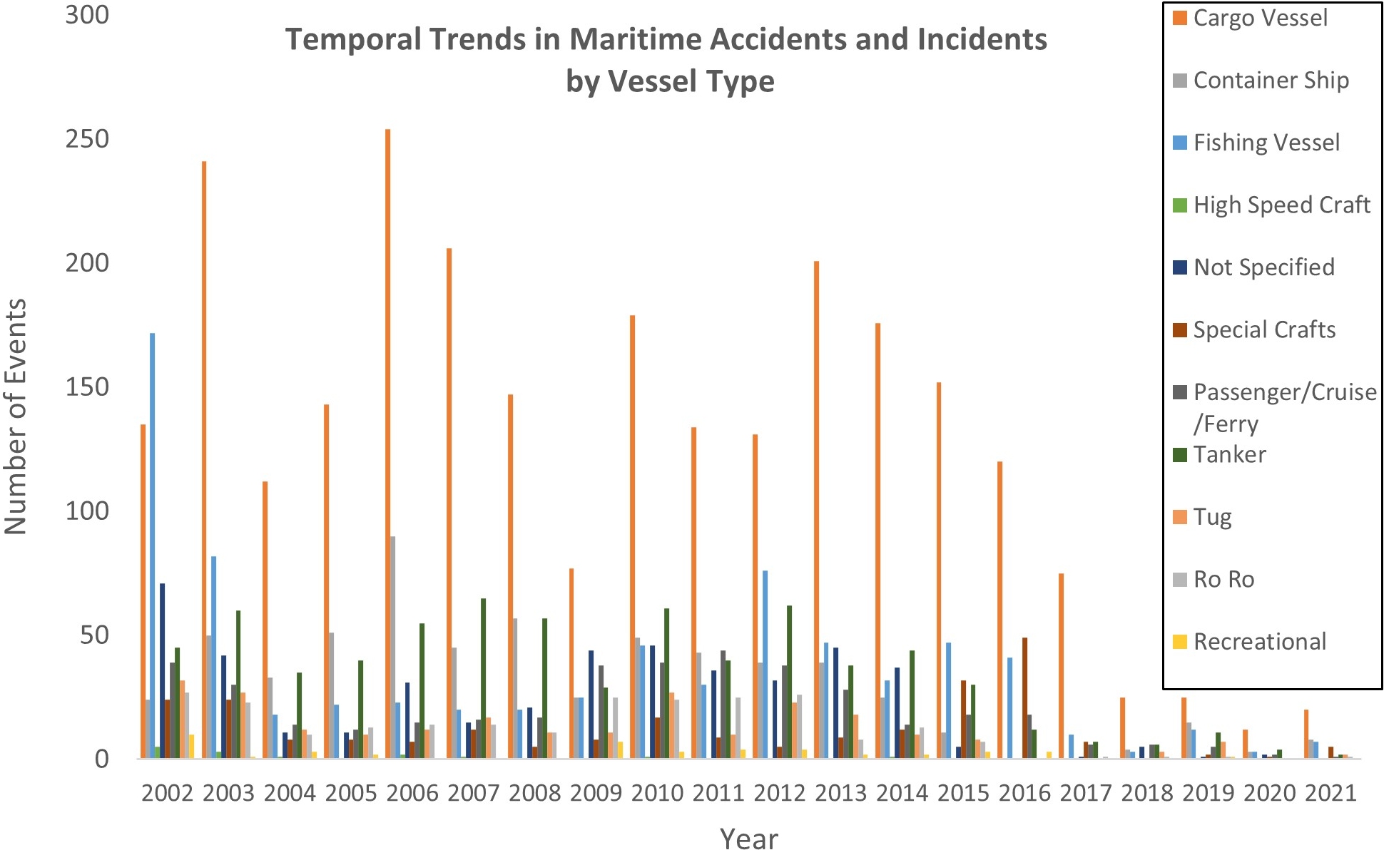
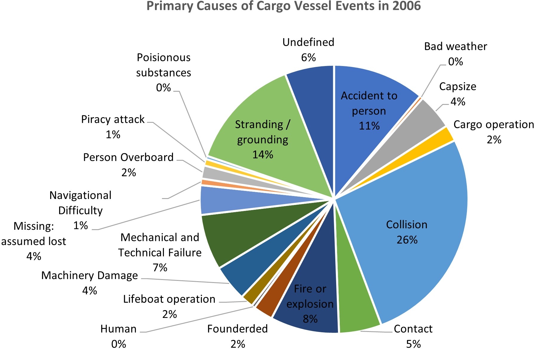
An analysis of maritime accidents and incidents by vessel type from 2002 to 2021 reveals notable temporal variations (Fig. 3). Throughout the study period, cargo vessels consistently recorded the highest number of events, reaffirming their status as the most frequently involved vessel type in maritime accidents. The year 2006 (Fig. 4) saw the highest number of cargo vessel events (254 cases). with collisions accounting for 26 %, followed by groundings (14 %) and accidents involving personnel (11%). A significant decline in cargo vessel events was observed after 2013, likely due to the introduction of newer cargo carriers with improved safety measures and technology (Butt et al., 2015). Other vessel types also exhibited distinct peak years, with container ship incidents reaching their highest in 2006 (90 cases) and fishing vessel accidents peaking in 2002 (172 cases). High-speed crafts and recreational vessels had minimal occurrences, whereas other offshore ships recorded their highest number of events in 2016 (49 cases). It is important to note that the decline in reported events from 2018 onward may not reflect an actual reduction in accidents, but rather incomplete records in the GISIS IMO Database for 2018–2021. This pattern is likely due to delayed reporting in the GISIS IMO Database, as earlier years in the dataset also showed artificially low counts until records were updated in subsequent years. This potential underreporting highlights the need for improved data collection mechanisms to ensure a more accurate representation of maritime accident and incident trends.
5.2 Distribution of maritime accident causes
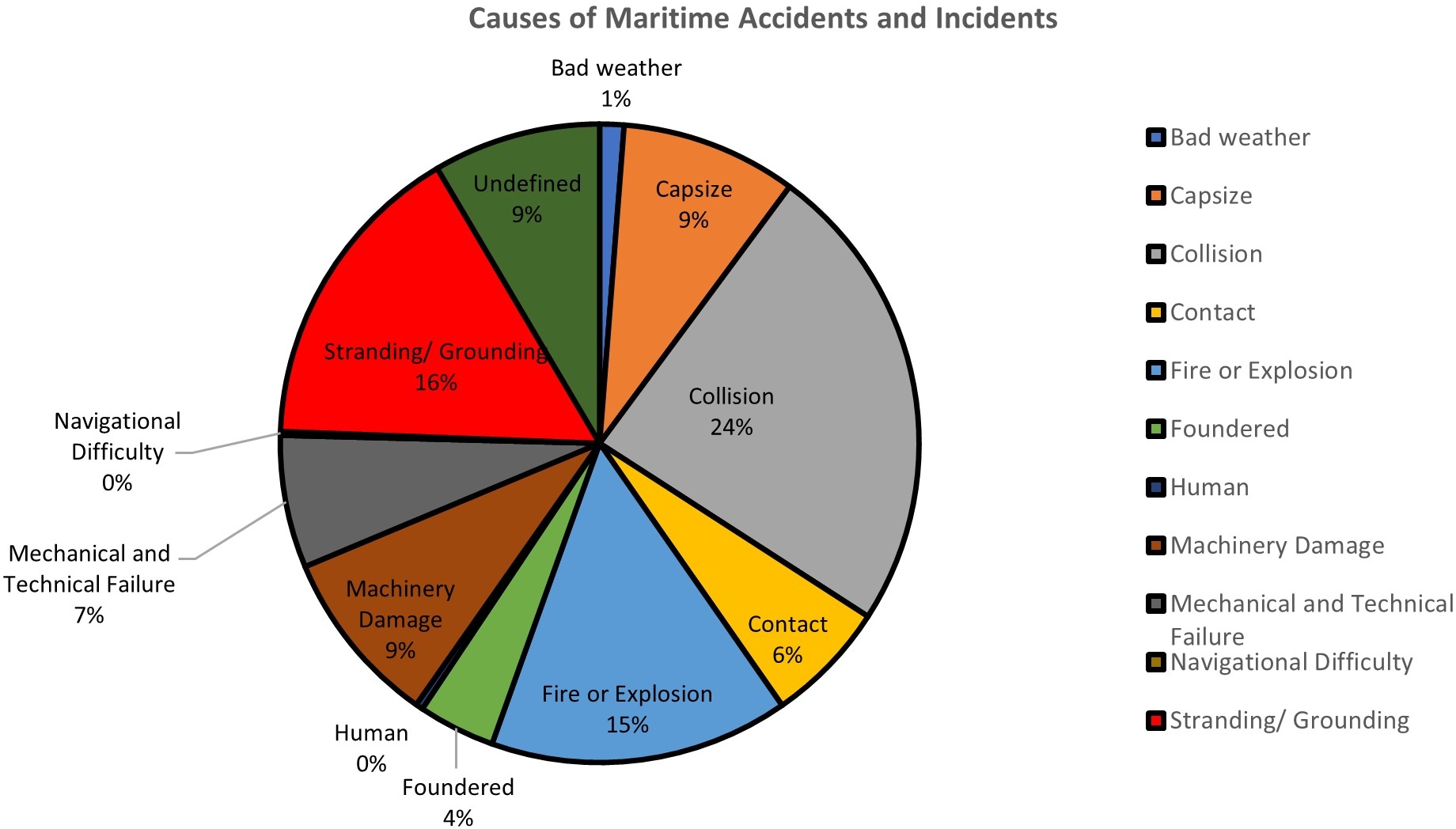
The analysis of maritime events reveals distinct variations in frequency and causation factors across different incident categories. Collisions emerged as the most prevalent accident type, with 1,254 recorded cases, attributed to navigational challenges in congested ports and narrow waterways (Fig. 5). Factors such as restricted visibility, high traffic density, and limited manoeuvring space further increase collision risks, making them a major maritime safety concern.
Stranding/grounding events ranked second, accounting for 16 % of total accidents (832). These events often result from navigational errors, unfavourable currents, wave impacts, or excessive speed (Antão & Guedes Soares, 2006). While groundings pose fewer risks to human life, they increase environmental hazards, such as oil spills and hull damage. Fires and explosions were the third most frequent accident type (15 %, 792 cases), primarily caused by engine failures, electrical malfunctions, or hazardous cargo combustibility (Akten, 2006). These events disproportionately affect tankers and container ships, reinforcing the need for fire prevention measures and advanced firefighting systems. Machinery damage and capsizing events each accounted for 9 %, with 468 and 466 recorded cases, respectively. Machinery failures often stem from structural weaknesses or mechanical breakdowns, leading to propulsion or steering loss (NTSB, 2017). Capsize events, on the other hand, are frequently linked to improper cargo loading, shifting cargo, progressive rolling, or extreme weather conditions (EMSA, 2014). Other notable causation categories include mechanical and technical failures (7 %, 351 cases), often involving engine malfunctions, GPS failures, or overpressure scenarios (Awal & Hasegawa, 2017). Contact-related events (6 %, 324 cases), occur when vessels collide with submerged objects, offshore platforms, or berths due to adverse weather and navigational miscalculations. Foundering events accounted for 4 % of accidents, occurred primarily in high-risk regions such as the North Sea and Black Sea. These events were typically caused by hull integrity failures, propulsion system breakdowns, and severe storms. The distribution of maritime causation factors highlights the complexity of vessel risks, reinforcing the need for targeted safety interventions that address navigational challenges, human factors, equipment reliability, and environmental conditions. Implementing vessel-specific risk mitigation strategies is essential for enhancing maritime safety and reducing accident rates worldwide.
5.3 Leading cause of maritime events per year
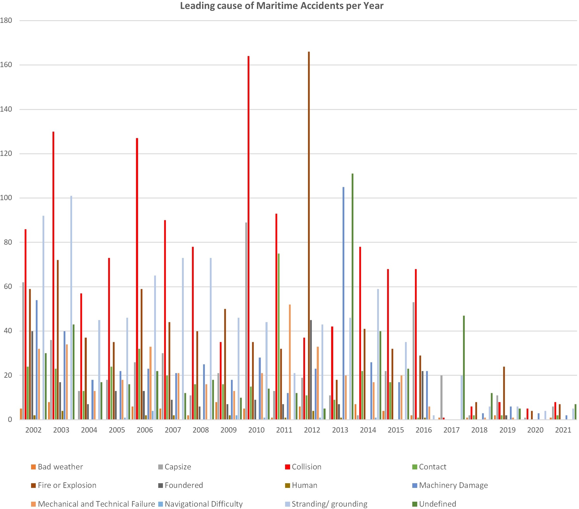
The frequency and nature of maritime events have fluctuated significantly over the study period, with collisions, groundings, and fires or explosions emerging as the most prevalent accident types (Fig. 6). The analysis highlights that certain vessel types are more susceptible to specific accident categories, with cargo vessels, container ships, and tankers most frequently involved in collisions, while cargo vessels and tankers also accounted for a significant share of groundings and fire-related incidents. Between 2011 and 2021, the leading causation factor alternated between collisions and groundings, though collisions remained the dominant accident type for most of the study period. Cargo vessels, tankers, and container ships were consistently the most affected vessel types. Notably, collision events declined significantly in 2017, with only one recorded case. However, this trend reversed over the next three years, with a steady increase in collision occurrences. This fluctuation suggests that while advancements in navigational technologies, safety regulations, and vessel monitoring systems may have temporarily reduced collision rates, dense maritime traffic, congested port operations, and human error continue to be major risk factors.
A closer examination of temporal trends reveals that groundings were the most frequently reported incident in 2002. However, from 2003 to 2008, 2010–2011, and from 2014 onward, collisions overtook groundings as the most common maritime event. Despite this shift, groundings remained notably high in 2002, 2009, 2012, and 2013, which may be associated with shallow-water navigation, adverse weather conditions, and depth miscalculations significantly contributed to accident occurrences during these years. The dominance of collisions and groundings throughout the study period highlights the critical need for enhanced navigational safety measures, stricter traffic separation schemes, and improved situational awareness training for vessel operators. While collisions remain the primary concern due to their high frequency and potential for severe consequences, groundings pose substantial risks, particularly in environmentally sensitive areas, where they can lead to hazardous spills and long-term ecological damage. Addressing the root causes of these accidents through regulatory oversight, technological advancements, and improved vessel traffic management is crucial in reducing future maritime incidents and ensuring safer global shipping operations.
5.4 Analysis of work-related injuries and fatalities among seafarers and passengers
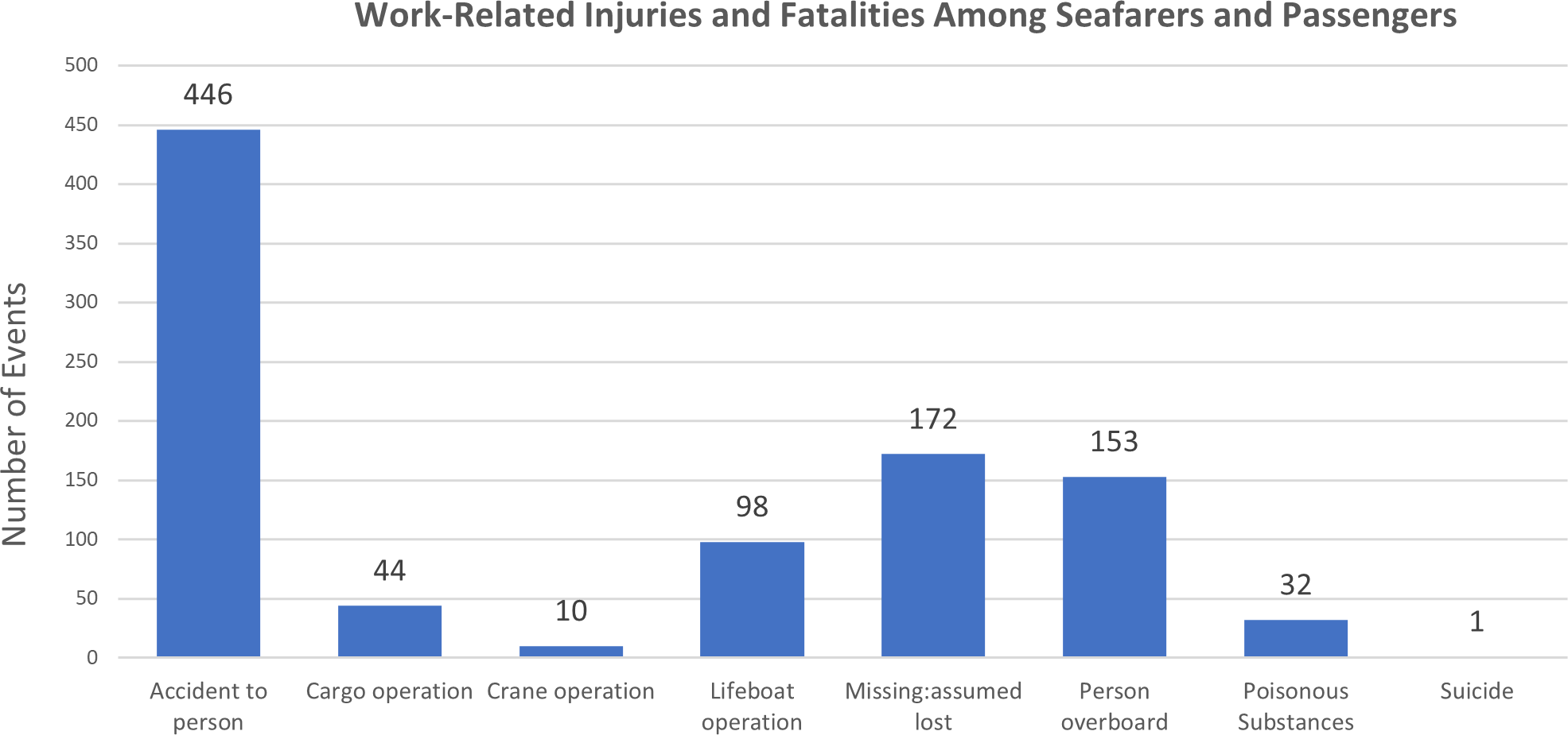
Maritime fatalities and injuries are not solely the result of vessel-related events such as collisions and groundings; many occur due to hazards associated with onboard work processes (Butt et al., 2015). Various sections of a vessel including the deck, cargo area, engine room, and galley pose occupational risks to crew members, often leading to serious injuries or fatalities. The analysis of work-related accidents highlights several dominant categories (Fig. 7). Among these, Accidents to Persons emerge as the leading category (446 cases), encompassing trips and falls, fatal medical emergencies such as heart attacks, and structural failures. Missing: Assumed Lost refers to crew members who disappeared while on duty and were never recovered, underscoring gaps in monitoring and onboard safety procedures. Persons Overboard incidents, where mariners fall into the sea during work-related activities, pose grave risks due to hypothermia, drowning, and delayed rescue responses. Similarly, lifeboat operations present notable occupational hazards, with accidents occurring during routine drills, emergency evacuations, and equipment malfunctions.
The high incidence of work-related injuries and fatalities underscores the occupational dangers of maritime professions, emphasizing the need for enhanced safety protocols, improved crew training, and stricter enforcement of onboard risk management measures. Reducing these risks requires advanced safety equipment, standardized emergency response training, and rigorous compliance with international labour safety regulations. Implementing these measures can significantly lower accident rates and improve overall maritime workplace safety.
5.5 Maritime events by time of day: Yearly analysis
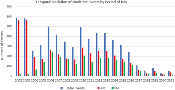
A detailed analysis of maritime events from 2002 to 2021 reveals significant variations between morning (AM) and evening (PM) accident frequencies. The findings indicate that most events occurred during morning hours, suggesting a correlation between increased operational activity and heightened accident risks during daytime navigation (Fig. 8). The highest number of AM events was recorded in 2002 and 2003, with 565 reported cases, while PM events remained significantly lower, with only 18 occurrences. This pattern underscores the heightened exposure to maritime risks during peak operational hours, when vessel movements are at their highest. Conversely, in 2010, AM events were the third highest on record (287 events), whereas 2020 had the lowest AM events (19 cases), likely due to reduced maritime activity during the COVID-19 pandemic. For PM events, the highest number of cases occurred in 2006, with 242 events. Apart from the historically low PM accident counts in 2002 and 2003, 2020 also recorded one of the lowest evening incident totals, with only 8 occurrences. These findings highlight the need for heightened vigilance during high-risk operational periods, particularly morning hours when vessel activity peaks. The discrepancy between AM and PM accident frequencies suggests that factors such as crew workload, fatigue, reduced visibility, and port congestion contribute to elevated accident rates during peak hours. Recognizing these temporal patterns is essential for developing strategic interventions, including adjusting operational schedules, implementing fatigue management protocols, and enhancing vessel traffic management systems, to mitigate maritime risks during the most vulnerable periods.
5.6 Maritime events per hour
An hourly analysis of maritime events revealed notable discrepancies and distinct temporal trends in accident occurrences. A significant anomaly was identified in 2002 and 2003, where all reported events were recorded at 12:00 AM UTC. This systematic error in the GISIS IMO database, likely caused by default time entries or incomplete data submissions, artificially inflated midnight accident statistics. To ensure accurate trend analysis, these two years were excluded from further evaluations. The time interval 12:00 AM – 1:00 AM remained a high-risk, suggesting that restricted nighttime visibility, reduced situational awareness, and crew fatigue significantly contribute to navigational errors and accidents. Daily maritime event patterns exhibited distinct peaks at various times (Fig. 9). Early morning peaks (labelled “A” and “B”) align with heightened maritime activity, particularly port arrivals and departures, leading to increased congestion and higher risks of collisions, groundings, and fires. Cargo vessels, tankers, and container ships were the most frequently involved vessel types during these peak hours. Another significant spike occurred between 3:00 PM and 4:00 PM (labelled “C”), where collisions, groundings, and fires were the predominant accident types. The combination of extreme weather conditions, navigational complexities, and human error contributed to elevated risks during this period, especially in high-density port areas where vessels engage in frequent manoeuvring.
A key finding is that collisions, the leading cause of maritime events, peak during nighttime hours, particularly between 12:00 AM and 1:00 AM, with 754 recorded cases (Fig. 10). While this may reflect genuine risk factors such as limited visibility, obstacle detection challenges, and delayed reaction times, it is also possible that the peak is partially influenced by reporting anomalies in the GISIS IMO database. The highest number of vessel contact events with platforms and other fixed objects also occurred during this timeframe, with 26 recorded cases (Fig. 11), reinforcing the risks associated with poor nighttime navigation and inadequate lighting systems. These findings emphasize the need for strategic interventions to mitigate risks during high-incident periods. The high frequency of nighttime accidents underscores the importance of enhanced vessel monitoring, improved lighting and signalling systems, and stricter adherence to nighttime navigational protocols. Additionally, targeted measures such as adjusting port scheduling, enforcing fatigue management regulations, and deploying advanced navigational technologies can significantly reduce accident risks. Understanding these temporal trends is crucial for strengthening maritime safety measures and minimizing casualties at sea.
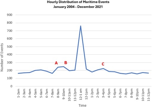
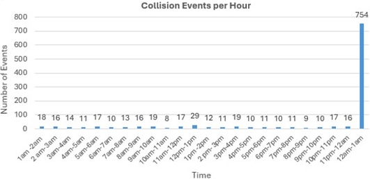
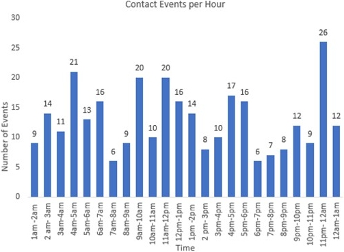
Fig. 11 Contact events per hour.
5.7 Seasonal distribution of maritime events
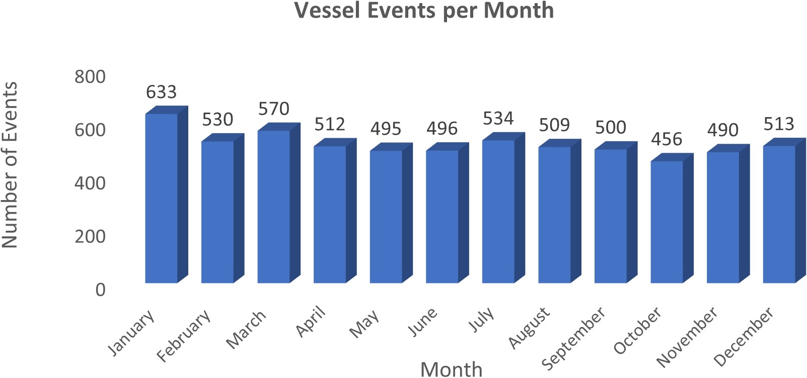
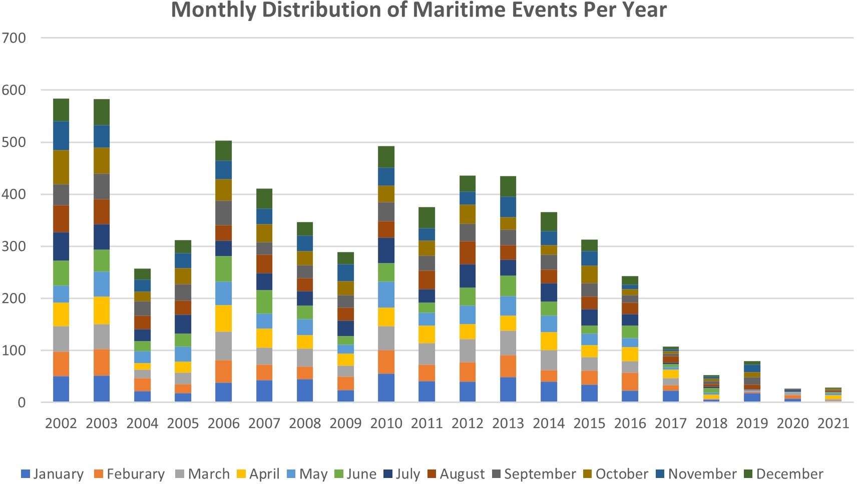
The analysis of seasonal trends reveals significant fluctuations in frequency throughout the year. As shown in Fig. 12, January recorded the highest number of reported accidents, with 633 occurrences, making it the most hazardous month for maritime operations. March and July followed, with 570 and 534 incidents, respectively, while October recorded the lowest accident count (456 cases), indicating a relative decline in maritime incidents during this period. A 20-year breakdown of monthly accident distribution confirms that January consistently exhibited the highest accident rates (Fig. 13). This seasonal peak was primarily driven by cargo vessel events, which appear more vulnerable to maritime risks during this time. The prevalence of adverse winter weather conditions in the Northern Hemisphere is a significant contributing factor, as vessels face rough seas, strong winds, and reduced visibility, all of which increase accident likelihood. The analysis further reveals that winter months (December to February in the Northern Hemisphere and June to August in the Southern Hemisphere) accounted for approximately 52 % of all maritime events. This aligns with the expected impact of extreme weather phenomena, including storms, high waves, and icy conditions, which pose substantial navigational challenges. However, 17 % of events were recorded between June and July, suggesting that early summer also presents notable risks. While this period follows a mid-year dip in May, the uptick may be influenced by seasonal weather changes, increased maritime traffic, and the intensification of cruise vessel operations during peak tourism months in the Northern Hemisphere. Although the dataset does not isolate cruise ship activity, the timing aligns with known cruise season patterns, warranting further investigation into the role of passenger vessel traffic in summer incident trends. This could be attributed to increased maritime traffic, seasonal weather shifts, and operational adjustments, all of which affect vessel manoeuvrability and accident risk. These findings emphasize the need for seasonally adjusted risk management strategies, particularly during high-risk months such as January and July. Enhanced weather monitoring, seasonal route planning, and stricter navigational safety protocols could help mitigate the impact of seasonal variations on maritime safety. Additionally, cargo vessels, which are disproportionately affected during peak accident months, should be a priority for targeted safety measures, ensuring improved operational preparedness during winter and early summer periods.
5.8 Impact of flag state on maritime accidents and incidents
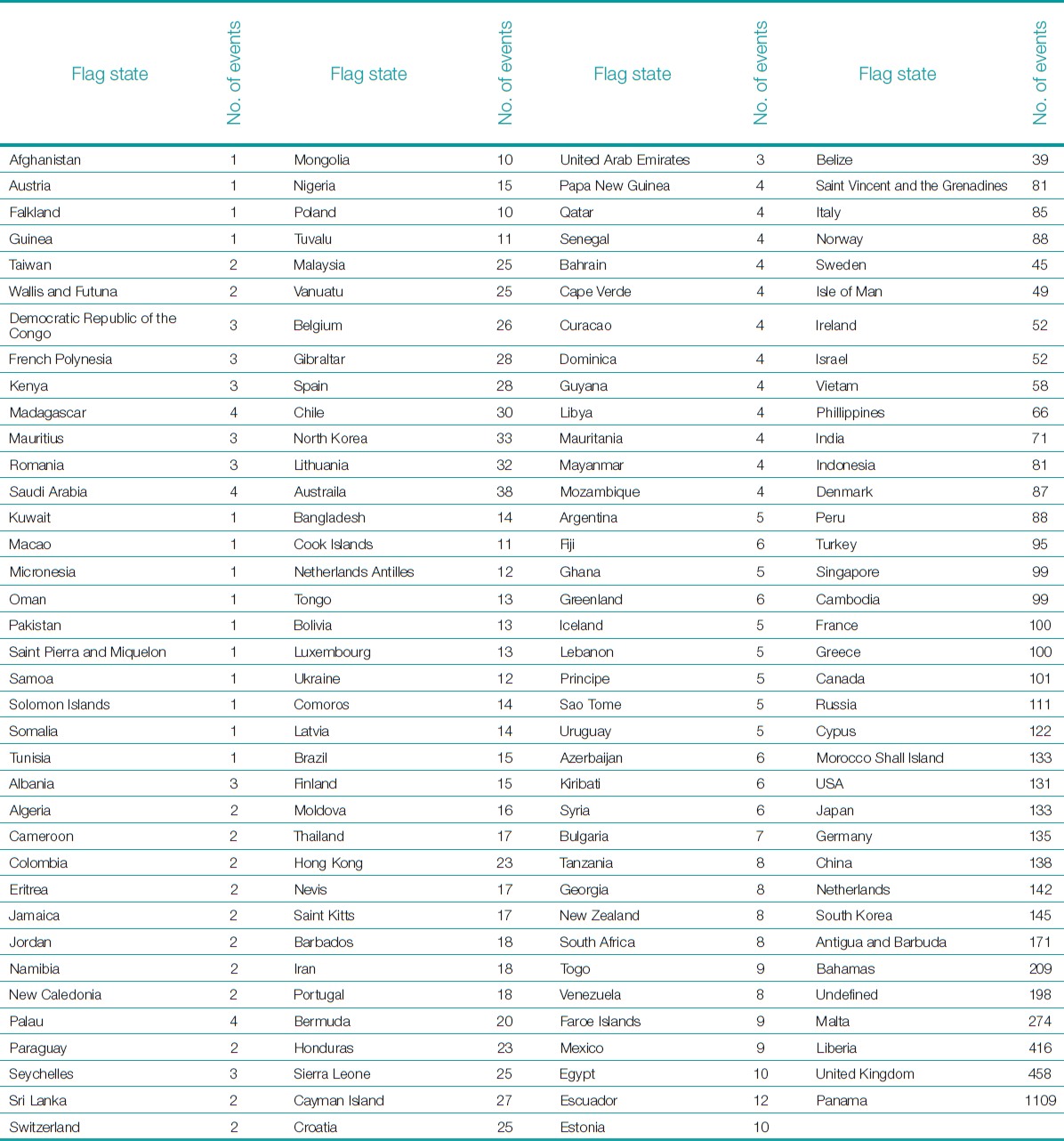
A vessel’s flag state plays a crucial role in maritime safety, influencing maritime accident rates through factors such as regulatory enforcement, vessel age, and operational oversight. While maritime events are often the result of multiple interrelated factors, studies have identified flag state, vessel age, and traffic volume as key contributors to accident probability. Under international maritime law, all merchant ships must be registered with a flag state, which assumes responsibility for ensuring compliance with safety regulations, vessel maintenance, and crew qualifications (Williams, 2015). However, flag state performance varies significantly, as evidenced by accident statistics across different registries. The age of vessels also plays a critical role, as technical standards and crew efficiency tend to deteriorate over time. Many studies have linked a higher probability of accidents to older vessels, often due to corrosion-related structural weaknesses, machinery failures, and reduced manoeuvrability (Görçün & Burak, 2015). While some argue that regular maintenance and repairs can mitigate age-related risks, vessel aging remains a notable concern in accident causation (Butt et al., 2015). Another major factor influencing maritime events is traffic density, with studies confirming that higher vessel activity levels in congested maritime routes correlate with increased accident risks (Stornes, 2015; Houghton & Ulmke, 2014). The review of maritime accidents by flag state reveals significant disparities in safety performance. Panama, which operates the world’s largest shipping registry, recorded the highest number of events (1,109 cases) (Table 1). The dominance of Panama-registered vessels in accident statistics can be attributed to its open registry system, which attracts foreign shipowners seeking to circumvent stricter safety regulations imposed by their home countries (Wang, 2017). The flexibility offered by open registries allows operators to reduce operational costs through lenient safety compliance requirements and the employment of lower-cost foreign labour, often at the expense of vessel maintenance and safety oversight. Following Panama, the United Kingdom registered the second-highest number of events (458), followed by Liberia (416) and Malta (274). Notably, 198 events were classified under “Undefined” flag state, representing cases where registry information was missing or unreported in the GISIS database. The high frequency underscores the need for more complete and standardized reporting. These findings highlight that while some flag states maintain relatively stringent safety regulations, others operate under lax enforcement mechanisms, contributing to higher accident frequencies. The persistent high accident rate among Panama-flagged vessels suggests that regulatory oversight remains insufficient, despite international efforts to improve compliance standards. Although normalizing accident counts by fleet size would provide a more precise measure of flag state safety performance, the lack of consistent historical fleet size data across the study period prevents such an adjustment in this analysis.
Within the Caribbean region, similar patterns were observed. The Bahamas recorded the highest number of maritime events among Caribbean flag states, with 209 reported cases, followed by Antigua and Barbuda (171) and Saint Vincent and the Grenadines (81). The high accident rates among these Caribbean registries can be linked to regulatory shortcomings, as weaker enforcement of safety standards and vessel inspections increases the likelihood of operational failures (Butt et al., 2015). These findings emphasize the critical need for stronger regulatory frameworks, enhanced oversight of open registries, and stricter enforcement of vessel maintenance standards. The prevalence of accidents among certain flag states underscores the necessity of global maritime governance reforms to ensure that ship registration policies prioritize safety over cost-cutting measures. Improving flag state accountability, standardizing safety regulations, and enhancing international cooperation will be essential in reducing accident rates and improving overall maritime safety.
5.9 Geographic distribution of maritime events
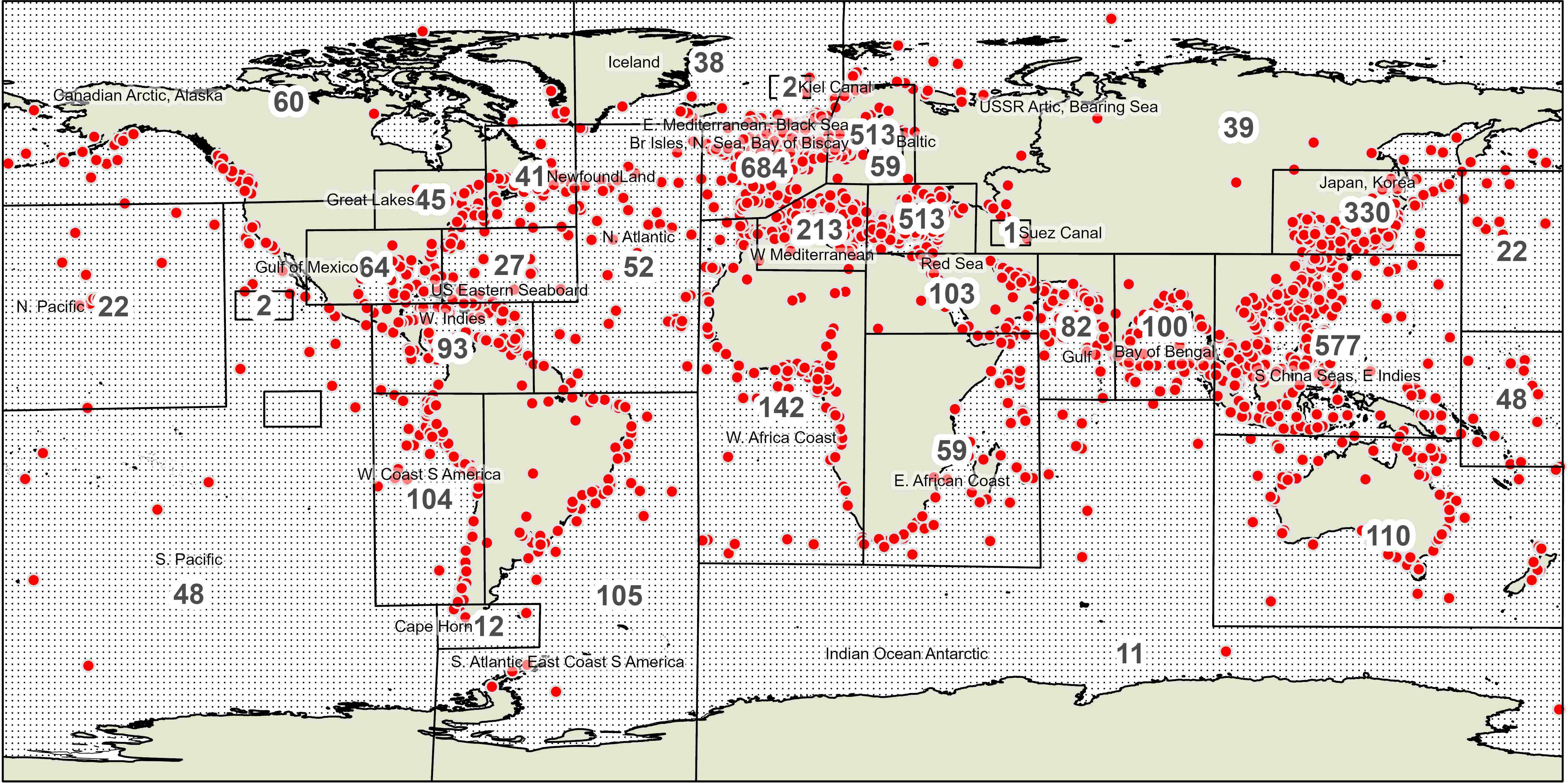
The analysis of maritime events by geographic area over the 20-year period reveals distinct high-risk zones where events occur more frequently. Variations in accident frequency may partly reflect differences in reporting practices across regions, with some high-risk areas potentially underrepresented in official records. Geographic accident patterns should also be interpreted in relation to vessel traffic density, as high-traffic routes face inherently greater exposure to maritime risks. Fig. 14 presents 3,676 maritime events; however, over 2,500 events recorded in the IMO database lack location details, suggesting that certain high-risk maritime areas may be underrepresented.
The regions with the highest number of maritime events were identified as:
- Bay of Biscay
- South China Sea (SCS)
- Eastern Mediterranean & Black Sea
- Japan & Korea
These maritime hotspots align with findings from Zhang and Feng (2018) in The Routledge Handbook of Transport in Asia, which analysed maritime accident distribution from 1978 to 2013. Their study highlighted similar high-risk areas, reinforcing that certain maritime regions have persistently high accident rates over multiple decades. A critical observation from these findings is the recurrence of events in densely trafficked waters, particularly in Europe and Asia, where port congestion, complex navigational routes, and high levels of commercial shipping activity contribute to heightened accident risks. Additionally, severe weather conditions, strong currents, and underwater obstructions further exacerbate the likelihood of maritime incidents in these regions.
The Bay of Biscay, located along the western European coast, is particularly known for adverse weather conditions, rough seas, and strong Atlantic storms, all of which pose significant navigational challenges for vessels. A breakdown of incident types in the Bay of Biscay reveals that collisions accounted for 126 cases, while groundings totalled 124 incidents. Additionally, fires and explosions were recorded in 64 cases, highlighting the diverse nature of maritime risks in this area. The South China Sea, a critical global shipping corridor, faces dense maritime traffic, geopolitical tensions, and unpredictable monsoon conditions, increasing the risk of collisions and vessel groundings. The South China Sea recorded 577 maritime events over the study period, with collisions accounting for 32 % of all events, followed by groundings (15 %) and fires/explosions (11 %). The high rate of collisions and groundings can be attributed to dense shipping traffic, contested maritime boundaries, and challenging weather conditions, which collectively increase the likelihood of navigational errors and operational hazards.
The geospatial distribution of maritime accidents provides key indicators for where international safety efforts should be focused. Strengthening safety regulations, enforcing navigational protocols, and improving vessel traffic management systems in these high-risk areas could significantly reduce the occurrence of maritime accidents. These findings highlight the dominance of cargo vessels in maritime incidents, emphasizing the need for targeted regional safety measures, including advanced navigational technologies, stricter enforcement of maritime safety laws, and enhanced training for crew members operating in high-risk areas.
5.9.1 Collisions
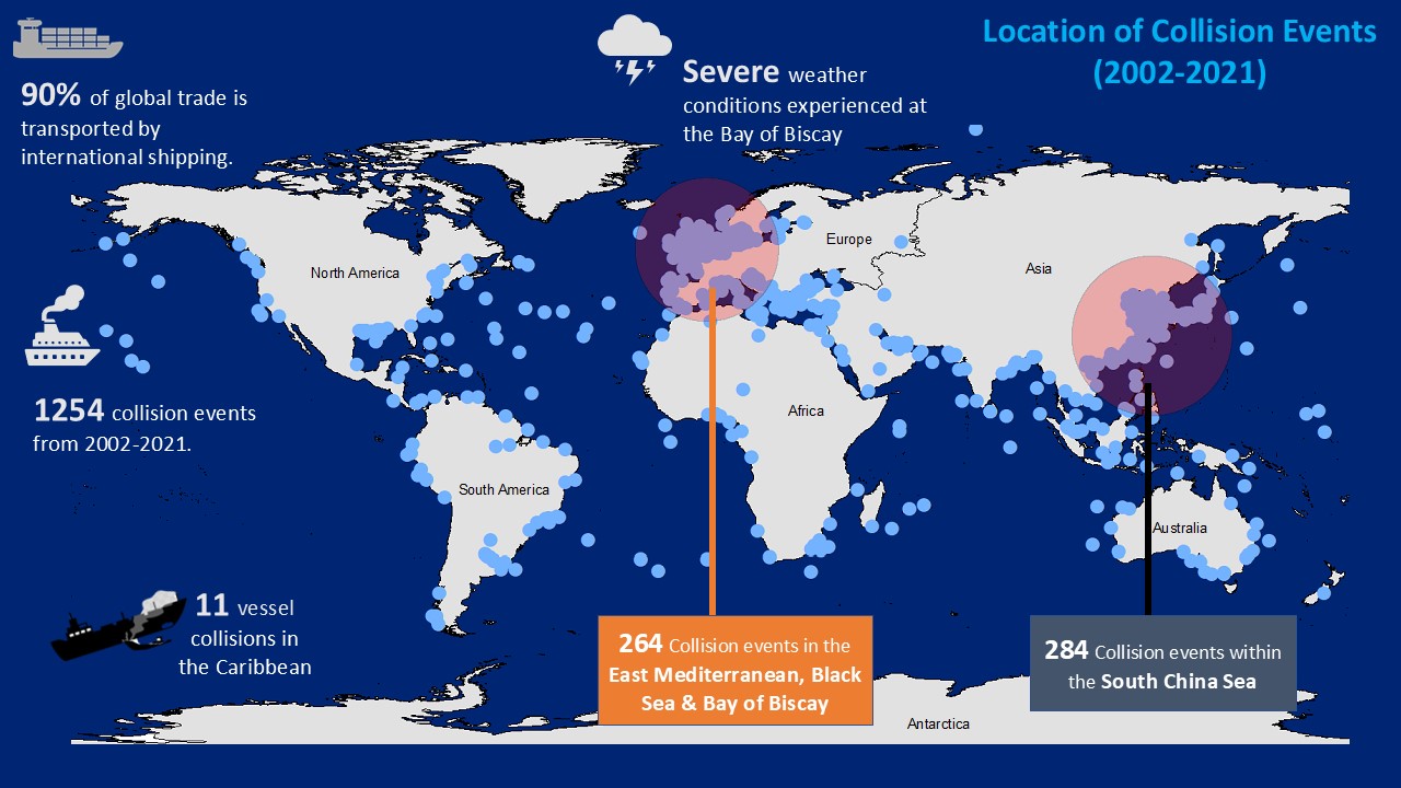
Collisions are frequently reported within the South China Sea (SCS), one of the world’s busiest and most geopolitically sensitive maritime regions (Fig. 15). The dominant vessel types operating in this area include cargo ships, container vessels, and tankers. This is largely due to the SCS serving as a critical maritime corridor linking the Indian Ocean with East Asia. Many of these vessels operate under a tramp trade regime, meaning they lack fixed schedules or designated routes, which contributes to navigational unpredictability and elevated risk. Moreover, the region is characterized by overlapping jurisdictional claims and competing interpretations of freedom of navigation within Exclusive Economic Zones (EEZs), which further intensify the risk of military encounters and accidental collisions. The Bay of Biscay records the second-highest number of maritime collisions globally. The area supports significant cargo, container, and fishing vessel traffic. Severe meteorological conditions are prevalent in this region, particularly during winter months, when the area is routinely affected by strong storms and persistent rainfall. The bay is notorious for the formation of depressions that intensify into thunderstorms, contributing to hazardous sea conditions and numerous reported shipwrecks. These observations highlight the strong influence of environmental conditions and regional geography on maritime incident patterns.
5.9.2 Foundered events
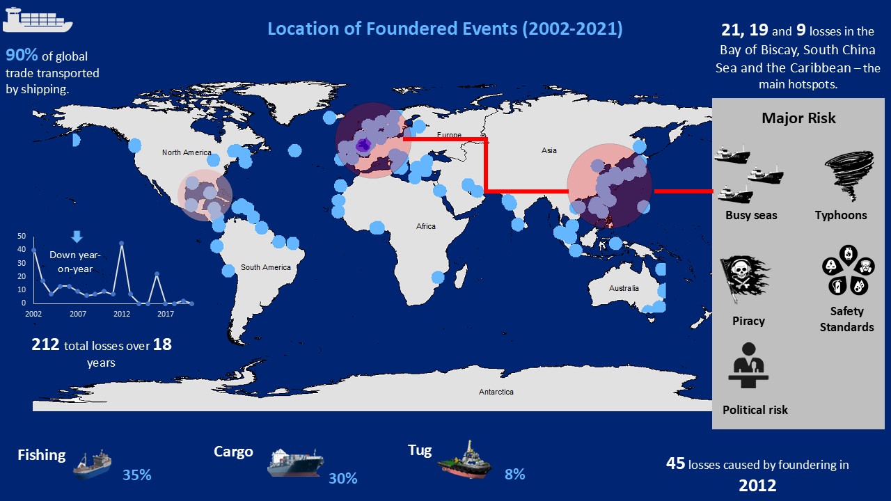
A similar spatial pattern is evident in the distribution of foundered incidents, which are closely tied to specific geographic regions and are often exacerbated by extreme weather conditions. The Bay of Biscay records the highest number of foundered events globally, followed by the South China Sea (Fig. 16). The Caribbean Sea, particularly the area encompassing the Panama Canal, ranks third. Vessels most commonly involved in these incidents include fishing vessels (35 %), cargo ships (30 %), and tugboats (8 %). Foundering is typically initiated by severe meteorological conditions or structural failures such as hull breaches or leaks. These types of incidents are also prevalent in the North Sea, Black Sea, and coastal waters around Japan regions characterized by dense maritime traffic and extensive short sea shipping networks. This distribution underscores the influence of environmental factors, vessel type, and navigational density on the occurrence of foundering.
5.9.3 Heavy weather and grounding events
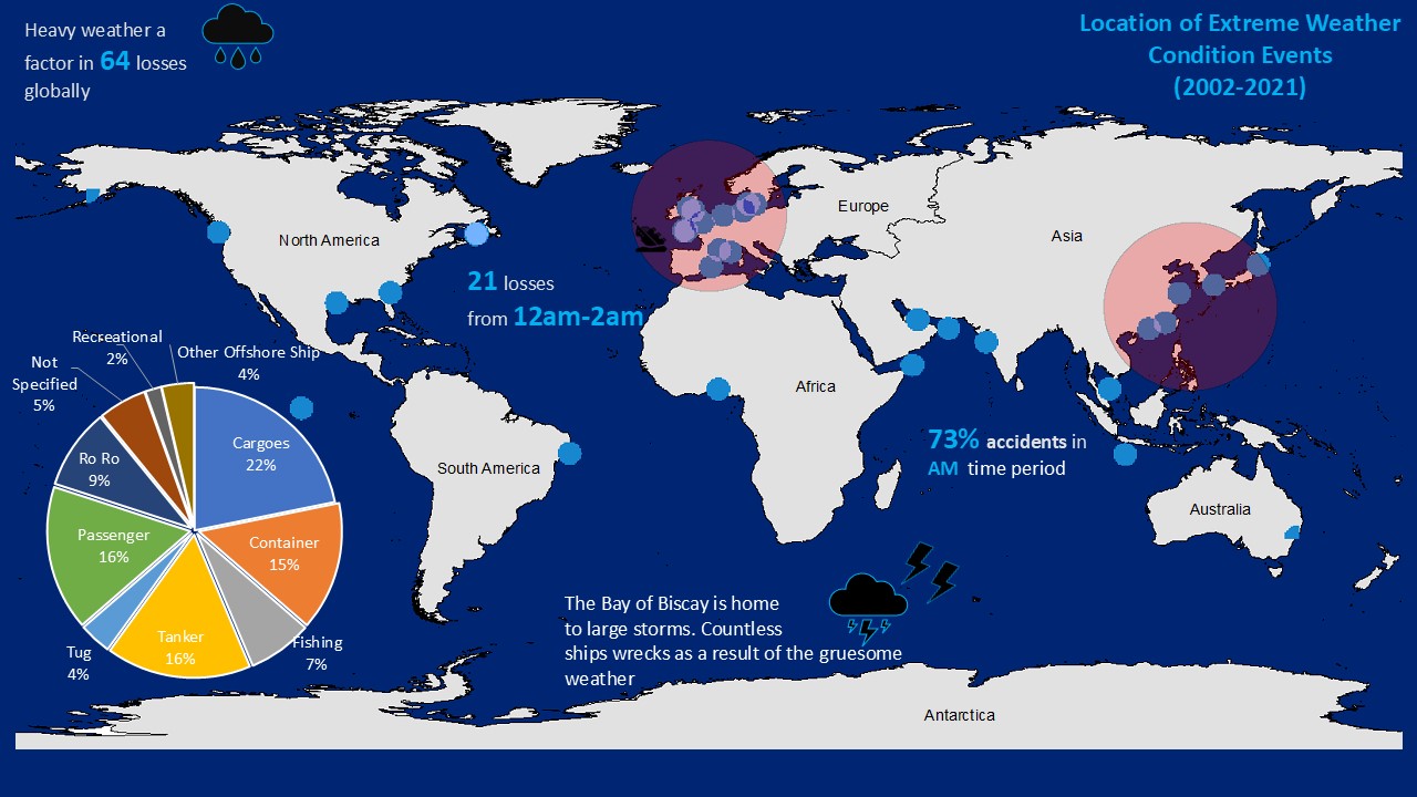
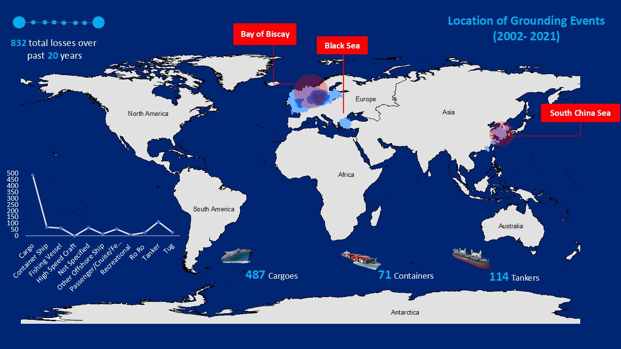
During the 20-year period under review, 64 maritime events attributed to heavy weather conditions involved a total of 10 different types of vessels (Fig. 17). Analysis reveals that cargo vessels were the most frequently affected, accounting for 27 % of the total, followed by passenger, cruise, and ferry vessels (16 %), and container vessels (15 %). A significant temporal pattern was also observed, with over 73 % of these incidents occurring during the AM period particularly between 12:00 AM and 2:00 AM. While this may partly be attributed to the severe weather conditions sometimes encountered during these hours, coupled with reduced visibility that increases navigational risk, it is also possible that the pattern reflects reporting inconsistencies or default time entries in the GISIS IMO database rather than actual accident timing. Likewise, 832 grounding incidents were recorded globally during the same timeframe, with the distribution also potentially reflecting reporting inconsistencies (Fig. 18). Cargo vessels were again the most frequently involved, accounting for 52 %, followed by tankers (12 %) and container ships (8 %). The East Mediterranean and Black Sea, Bay of Biscay, and the South China Sea emerged as the regions with the highest concentration of grounding events. Notably, 638 of these incidents occurred during AM hours, suggesting that reduced visibility, early-morning operational factors, and potential reporting inconsistencies may also play a role in these types of incidents.
5.10 Impact of vessel age on maritime accidents and incidents
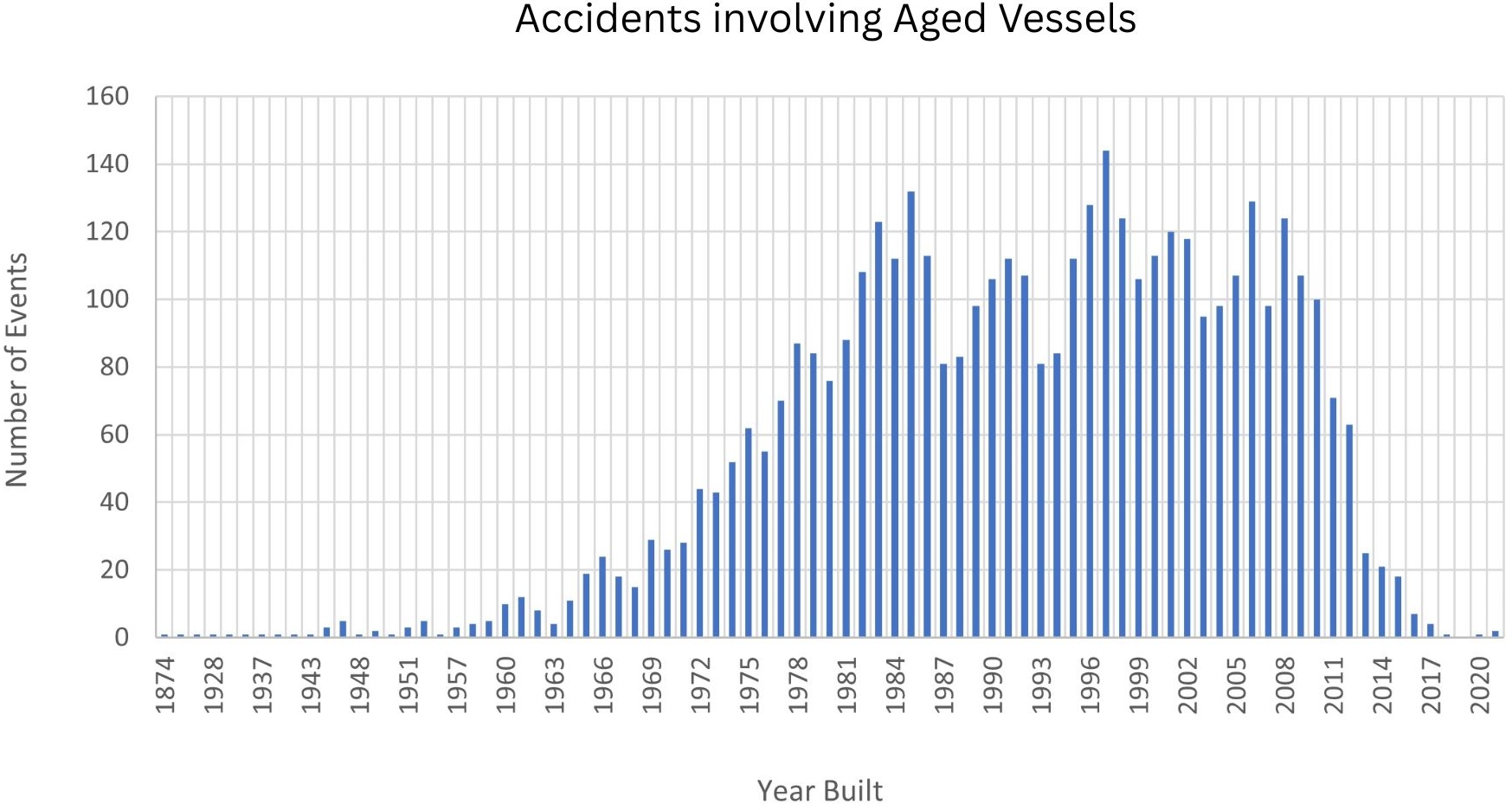
The analysis reveals a strong correlation between vessel age and accident frequency, with older vessels accounting for most maritime events (Fig. 19). Ships over 20 years old face higher risks due to aging structures, mechanical wear, and outdated safety systems. Vessels built in 1997 recorded the highest number of accidents (144), with 10 % registered under Panama and 6 % under Tanzanian and Comorian flags. This trend aligns with open registry policies, allowing older vessels to remain in operation under lenient regulatory frameworks. Similarly, 1985-built vessels recorded 132 events, ranking second, while 2006-built ships had 129 events, reinforcing the link between aging fleets and accident risks. Structural deterioration over time contributes to hull integrity issues, propulsion failures, and navigation system malfunctions, all of which increase accident likelihood (Butt et al., 2015). While routine maintenance can mitigate risks, aged vessels require more frequent repairs and stricter oversight. These findings highlight the need for stricter vessel age regulations, particularly for open registry states. Stronger international safety protocols, stricter inspections, and incentives for fleet modernization could significantly reduce accidents tied to aging vessels, improving global maritime safety.
6 Maritime accidents and incidents in the Caribbean Sea: Trends and comparative analysis
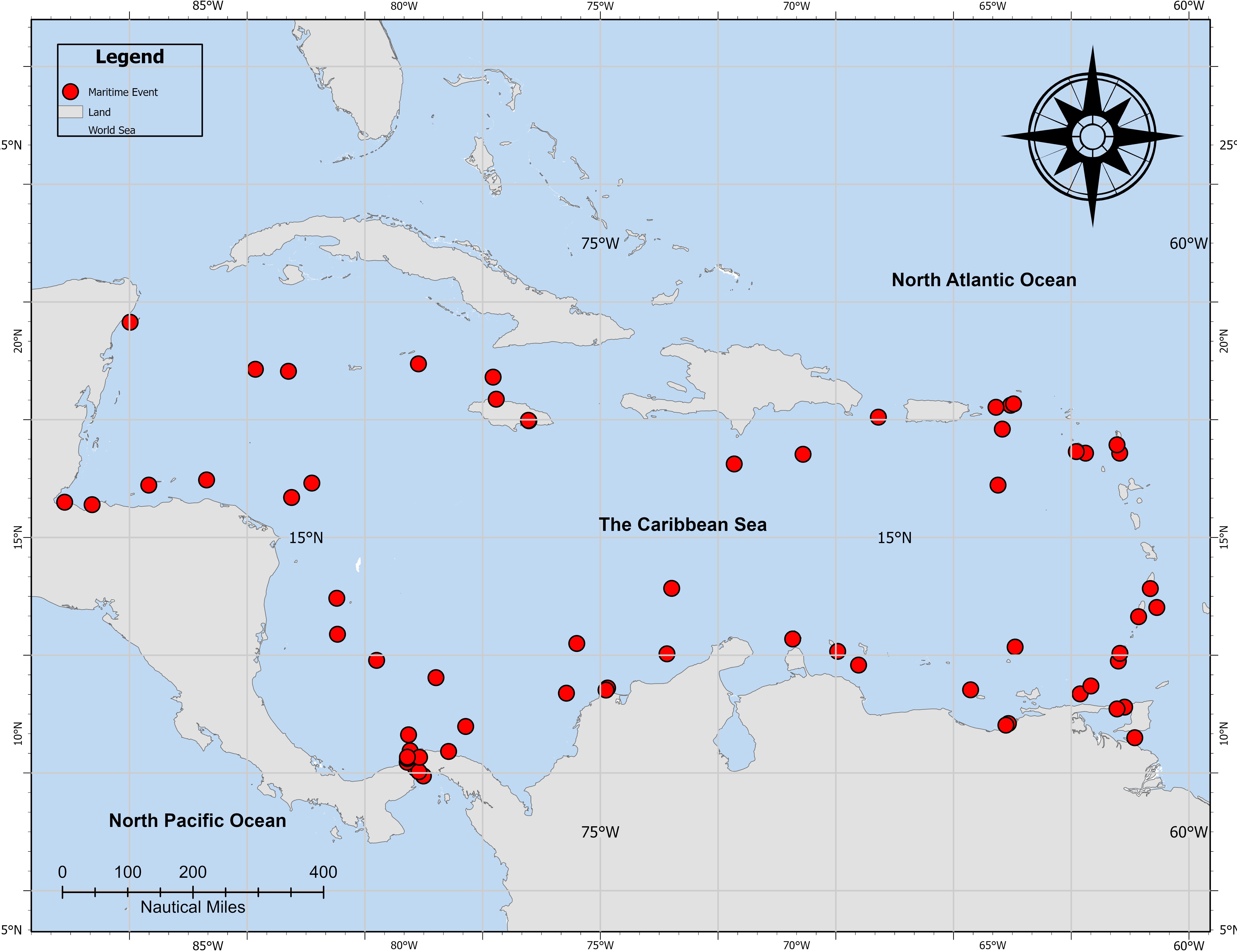
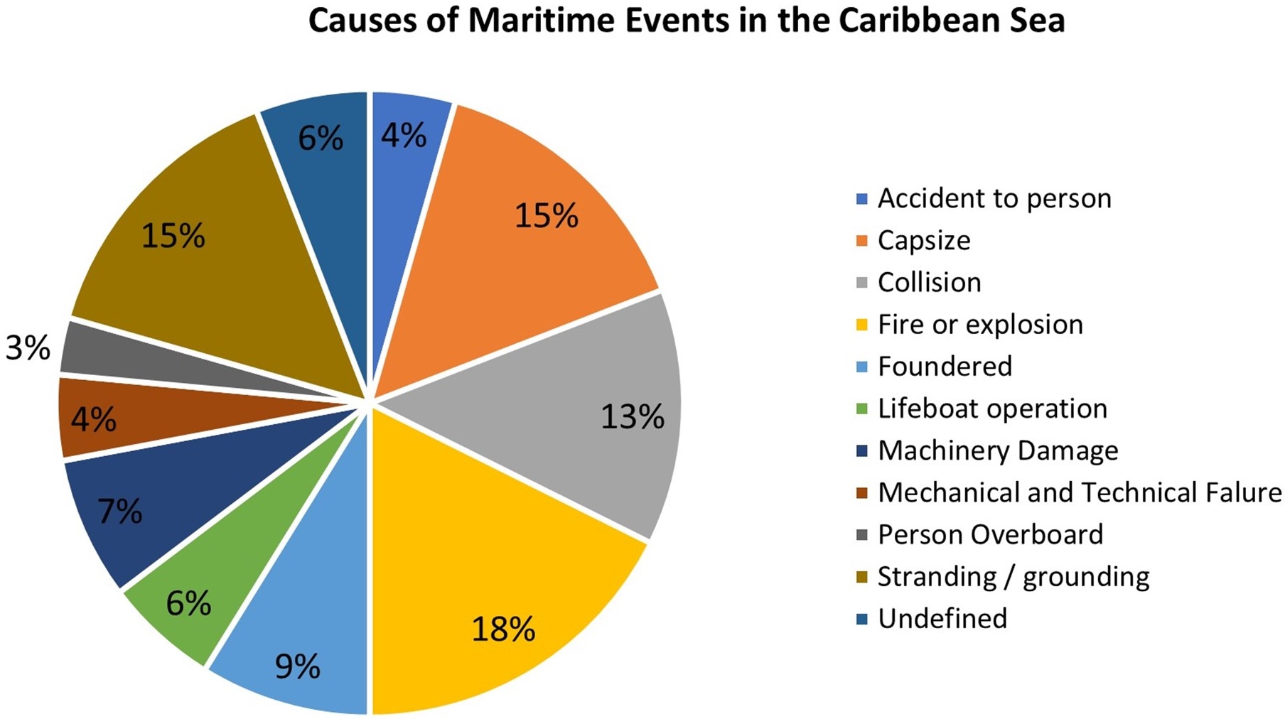
The Caribbean Sea, a major global shipping corridor, recorded 69 reported events between 2002 and 2021 (Fig. 20), accounting for just 1.1 % of worldwide maritime incidents. However, the nature and consequences of these events highlight significant regional risks. Fires and explosions were the most common causes, representing 18 % of all accidents, predominantly involving cargo vessels and tankers, followed by groundings (15 %), capsizing (15 %), and collisions (13 %; Fig. 21). This pattern contrasts with global trends, where collisions dominate (24 %), particularly in congested waterways such as the South China Sea, Bay of Biscay, and Black Sea. The high incidence of fires and explosions in the Caribbean aligns with global findings that tankers are especially vulnerable to fire-related events due to transporting flammable materials (Ugurlu et al., 2012). Despite SOLAS fire safety regulations, these incidents persist, underscoring the need for stricter enforcement and improved prevention measures (Molitor, 2012).
Groundings remain a critical concern in both regional and global contexts. In the Caribbean, cargo vessels are particularly at risk, operating along short sea shipping routes and frequently calling at smaller island ports with challenging hydrographic conditions. Contributing factors include navigational errors, adverse weather, submerged obstacles, and hydrographic uncertainties such as outdated charts, insufficient survey coverage, and inaccurate depth soundings. These risks are compounded in areas with dynamic seabed changes, sediment deposition, or uncharted hazards. In the Greater Caribbean Region (GCR), several risk assessments have found that many secondary ports and nearshore approaches still rely on historical survey data, reducing navigational confidence and increasing vulnerability to accidents in restricted waters (Miller, 2015; Seepersad et al., 2021).
6.1 The role of aged vessels in maritime events within the Caribbean Sea
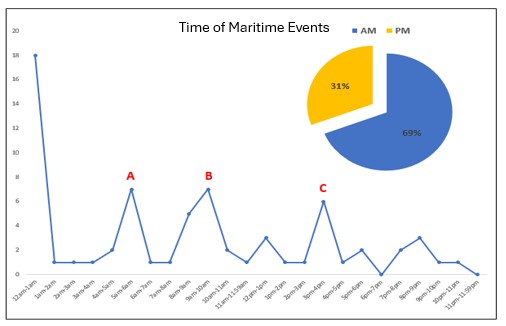
Despite the relatively low number of maritime events (69) in the Caribbean Sea, 41 events involved aged vessels. Analysis indicates that 29 events were recorded by vessels built between 1984 and 2004 and 12 events for vessels built between 1963 – 1983. This highlights the ongoing issue of older ships operating beyond their economic lifespan. Studies have consistently shown that aged vessels, particularly those over 20 years old, are at greater risk of structural failures, mechanical breakdowns, and compliance deficiencies. All events that occur at midnight (12AM–1AM) involved aged vessels built between 1991 and 1999. Additionally, cargo vessels accounted for 50 % of these events, followed by fishing vessels (17 %) and tankers (11 %). This trend aligns with global studies, indicating that older vessels operating under open registries are more prone to events due to substandard maintenance and safety compliance (Singh & Raju, 2016). A time-based analysis of maritime events in the Caribbean Sea also reveals notable patterns. Approximately 70 % of events occurred during morning hours (AM), with 41 recorded cases (Fig. 22). The highest concentration of events took place between 12 AM and 1 AM, a period associated with reduced visibility, crew fatigue, and navigational errors. Early morning peaks (labelled “A” and “B”) correspond to periods of high maritime activity, likely due to vessel arrivals, port calls, and increased traffic density. Evening events also follow distinct patterns, with a notable peak (labelled “C”) occurring due to capsizing incidents involving fishing vessels.
6.2 Flag state performance in maritime accidents in the Caribbean Sea
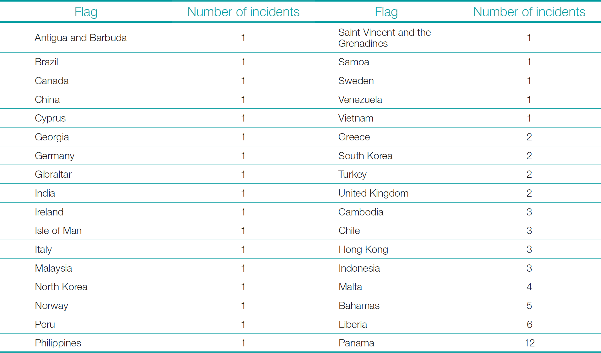
A review of the maritime events by flag state highlights Panama, Liberia, and the Bahamas as the most frequently involved registries within the Caribbean Sea (Table 2). Panama accounted for 12 events, followed by Liberia (6) and the Bahamas (5). Given that Panama operates the world’s largest open registry, this trend is expected, as many vessels registered under open registries prioritize cost savings over stringent safety compliance (Gasparotti & Rusu, 2012). Panama’s high accident involvement was primarily due to capsizing events, which accounted for 18 % of total regional events, followed by groundings and fires/explosions. Notably, 45 % of Panamanian-registered vessels involved in maritime events were cargo, tankers, or passenger vessels, further reinforcing concerns regarding the operational safety of aging vessels registered under open registries. These findings emphasize the critical need for stricter regulatory frameworks, enhanced oversight of open registries, and stronger enforcement of vessel maintenance standards. The prevalence of accidents among certain flag states underscores the necessity for global maritime governance reforms to ensure ship registration policies prioritize safety over cost-cutting measures.
7 Discussion
This study provides a comprehensive assessment of maritime events over the past 20 years, consolidating key insights into incident trends, vessel characteristics, flag state performance, and regulatory implications. A critical evaluation of maritime accident data underscores the importance of thorough statistical validation before drawing conclusions about accident causes and distributions. Although global accident rates have declined, poorly performing flag states continue to influence maritime risk. Other key determinants that influence a vessel accident includes vessel age, type, navigational environment, limited visibility, and operational timeframes. The study further highlights the need for enhanced regulatory oversight, stricter enforcement of international safety standards, and technological advancements to address persistent maritime risks.
Maritime safety has improved overall, with accident rates declining relative to fleet expansion due to advancements in technology, stricter port state controls, and international safety initiatives. However, accidents remain a persistent threat, particularly in high-risk regions and environmentally sensitive areas, where even minor incidents can cause severe ecological and economic damage (NTSB, 2017). Climate change further increases maritime risks, with storm surges, extreme weather, and changing ocean patterns expected to escalate vessel foundering and navigational hazards (Hauser et al., 2018). Smaller vessels, particularly those in coastal waters, remain more vulnerable to accidents than larger ocean-crossing ships. The study also confirms that human fatigue significantly impacts maritime safety, aligning with Project Horizon’s findings, which showed that sleep deprivation impairs watchkeepers’ cognitive performance, increasing collision and grounding risks (Frith, 2020). Despite safety advancements, poor-performing flag states continue to be a major concern, especially due to inconsistent enforcement of IMO conventions and outdated reporting frameworks, which hinder accurate accident investigations particularly for underreported fishing vessel and work-related onboard incidents.
In the Caribbean Sea, unique challenges such as unregulated Traffic Separation Schemes (TSS), aged vessels, and weak regulatory enforcement further complicate safety efforts. To address these risks, the study recommends:
- Strengthening flag state regulations by enforcing stricter IMO compliance on open registries.
- Implementing TSS to reduce congestion and collision risks.
- Clarifying that TSS issues pertain to inadequate implementation or supervision of existing schemes, rather than the absence of regulation.
- Enhancing fatigue management through better scheduling, improved aids to navigation, and collision avoidance technologies.
- Improving accident reporting systems by establishing a standardized global database, particularly for fishing vessels and onboard work-related incidents.
- Encouraging fleet modernization by phasing out aged vessels and promoting investment in safer ship designs.
- Expanding regional cooperation among Caribbean port authorities and international oversight bodies to enhance enforcement and vessel inspections.
- Strengthening hydrographic surveys, particularly in secondary ports and approaches, to reduce grounding risks linked to chart insufficiencies.
- Encouraging non‑IHO member Caribbean states to join the IHO, thereby enhancing hydrographic capacity across the region. Trinidad and Tobago is already a member of the Meso-American and Caribbean Sea Hydrographic Commission (MACHC), while six countries in Central America (Panama, Costa Rica, Nicaragua, Honduras, El Salvador, Belize), and seven islands (Antigua and Barbuda, Barbados, Grenada, Haiti, Saint Kitts and Nevis, Saint Lucia, Saint Vincent and the Grenadines) are not IHO Member States (IHO, 2025).
These measures are essential to improving maritime safety, reducing accident risks, and ensuring sustainable shipping operations worldwide.
8 Conclusion
This study highlights persistent risks and evolving safety challenges within global and Caribbean Sea maritime operations. While technological advancements and regulatory improvements have contributed to a decline in accident rates, key vulnerabilities remain, particularly regarding collisions, nighttime navigation risks, aged vessels, and open registry oversight. In the Caribbean Sea, the absence of Traffic Separation Schemes (TSS) in certain routes, reliance on aged vessels, and open registry policies present significant safety concerns. Panama, Liberia, and the Bahamas continue to dominate accident statistics, largely due to lenient registration policies that attract older and potentially substandard vessels. To improve maritime safety, stricter enforcement of international regulations is necessary, particularly for open registries. Encouraging fleet modernization by phasing out older, high-risk vessels could significantly reduce accident rates. Additionally, implementing fatigue management systems could help mitigate human error risks, particularly during late-night and early-morning navigation periods. Strengthening nighttime navigation safety through improved lighting, automated alert systems, and the establishment of TSS in congested areas could further reduce collision risks. Beyond regulatory and operational measures, the adequacy of hydrographic surveys in the Caribbean Sea plays a vital role in navigational safety. Several areas in the region still rely on outdated or incomplete survey data, which may not accurately reflect current seabed conditions, shifting channels, or newly emerging hazards. Such deficiencies increase the likelihood of grounding incidents, particularly for vessels operating in shallow or poorly charted waters. Updating nautical charts through systematic hydrographic surveys and promoting International Hydrographic Organization (IHO) membership among non-member states, could significantly enhance situational awareness and reduce accident risks. These findings provide critical insights for policymakers, regulatory bodies, and maritime operators. Addressing maritime safety challenges through technological advancements, stricter oversight, and enhanced risk management while prioritizing up-to-date hydrographic data will be crucial for ensuring a safer and more sustainable maritime industry worldwide.
References
Akten, N. (2006). Shipping accidents: A serious threat for marine environment. Black Sea/Mediterranean Environment, 12, 269–304. http://www.blackmeditjournal.org/pdf/2006_vol12_no3-5.pdf (last accessed 21 August 2025).
Akyuz, E. and Celik, M. (2014). Utilisation of cognitive map in modelling human error in marine accident analysis and prevention. The Scientific World Journal, 1–28. https://doi.org/10.1155/2014/489461
Antão, P. and Guedes Soares, C. (2006). Fault-tree models of accident scenarios of RoPax vessels. International Journal of Automation and Computing, 3(2), 107–116. https://doi.org/10.1007/s11633-006-0107-8
Awal, Z. I. and Hasegawa, K. (2017). A study on accident theories and application to maritime accidents. Procedia Engineering, 194, 298–306. https://doi.org/10.1016/j.proeng.2017.08.149
Baldauf, M. (2016). Improving and assessing the impact of e-navigation applications. International Journal of E-Navigation and Maritime Economy, 4, 1–12. https://doi.org/10.1016/j.enavi.2016.06.001
Bowo, L. P., Mutmainnah, W. and Furusho, M. (2017). The development of marine accidents human reliability assessment approach: HEART methodology and MOP model. TransNav: The International Journal on Marine Navigation and Safety of Sea Transportation, 11(2), 249–254. https://doi.org/10.12716/1001.11.02.06
Butt, N., Johnson, D., Pryce-Roberts, N. and Vigar, N. (2015). 15 years of shipping accidents: A review for WWF. Southampton Solent University, Southampton, UK. http://awsassets.panda.org/downloads/15_years_of_shipping_accidents_a_review_for_wwf_.pdf (last accessed 21 August 2025).
Calder, B. R. and Kurt, S. (2009). Traffic analysis for the assessment of risk assessment methods. US Hydrographic Conference. The Hydrographic Society of America, Stamford, USA.
EMSA (2014). Annual overview of marine casualties and incidents 2014. European Maritime Safety Agency, Lisboa, Portugal. https://www.emsa.europa.eu/publications/reports/download/3149/2303/23.html (last accessed 3 September 2025).
Fratila, A., Gavril, I. A., Nita, S. C. and Hrebenciuc, A. (2021). The importance of maritime transport for economic growth in the European Union: A panel data analysis. Sustainability, 13(14), 7961. https://doi.org/10.3390/su13147961
Frith, J. (2020). Human error accounts for 75% of marine liability losses. Maritime Journal, Fareham, UK. https://www.maritimejournal.com/news101/insurance,-legal-and-finance/human-error-accounts-for-75-of-marine-liability-losses
Gasparotti, C. and Rusu, E. (2012). Methods for the risk assessment in maritime transportation in the Black Sea Basin. Journal of Environmental Protection and Ecology, 13(3A), 1751–1759.
Gomez Pretel, W., Jeong, M., Rodríguez-Gutiérrez, C. E. and Ortiz, A. J. R. (2023). Preserving sunken military vessels as underwater cultural heritage in Colombia: Legal challenges and prospects for the USS Kearsarge wreck site. Heritage, 6(6), 4843–4863. https://doi.org/10.3390/heritage6060250
Goerlandt, F. and Kujala, P. (2011). Traffic simulation-based ship collision probability modeling. Reliability Engineering & System Safety, 96(1), 91–107. https://doi.org/10.1016/j.ress.2010.09.003
Görçün, Ö. F. and Burak, S. Z. (2015). Formal safety assessment for ship traffic in the Istanbul Straits. Procedia – Social and Behavioral Sciences, 207, 252–261. https://doi.org/10.1016/j.sbspro.2015.10.094
Hauser, D. D. W., Laidre, K. L. and Stern, H. L. (2018). Vulnerability of Arctic marine mammals to vessel traffic in the increasingly ice-free Northwest Passage and Northern Sea Route. Proceedings of the National Academy of Sciences, 115(29), 7617–7622. https://doi.org/10.1073/pnas.1803543115
Houghton, K. and Ulmke, M. (2014). Semi-automatic sea lane extraction combining particle filtering and geographic information systems. Proceedings of GI_Forum 2014: Geospatial innovation for society, 2, 2–11. https://doi.org/10.1553/giscience2014s2
IHO (2025). Yearbook 26 August 2025. IHO Periodic Publication P-5, International Hydrographic Organization, Monaco. https://iho.int/uploads/user/pubs/periodical/P5YEARBOOK_ANNUAIRE.pdf (last accessed 3 September 2025).
IMO (2012). Implications of the United Nations Convention on the Law of the Sea for the International Maritime Organization. International Maritime Organization, London, United Kingdom. https://no0ilcanarias.wordpress.com/wp-content/uploads/2012/11/implications-of-unclos-for-imo.pdf (last accessed 3 September 2025).
IMO (2025). Protecting the environment. International Maritime Organization, London, United Kingdom. https://www.imo.org/en/OurWork/Environment/Pages/Default.aspx (last accessed 21 August 2025).
Johansson, J. and Molitor, E. (2011). Risk assessment of the vessel traffic in the Kattegat including effects of traffic separation schemes from the Skaw to the Sound – Oil spill accidents relevant for the coast of Halland. http://193.183.15.115/PageFiles/27517/risk-ssessment-of-the-vessel-traffic-in-the-kattegat-eng-tot-21-march-2011.pdf (last accessed 21 August 2025).
Kujala, P. (2012). Influences of variables on ship collision probability in a Bayesian belief network model. Reliability Engineering and System Safety, 102, 27–40. https://doi.org/10.1016/j.ress.2012.02.008
Maharaj, A. (2020). Geostatistical analysis of marine traffic in the Gulf of Paria, Trinidad and Tobago (Master’s thesis). The University of the West Indies, The Republic of Trinidad and Tobago.
MAIB (2019). MGN 564: Marine casualty and marine incident reporting. Marine Accident Investigation Branch, Department for Transport, Southampton, UK. https://assets.publishing.service.gov.uk/media/5ca36e19ed915d0c55c71ef1/MGN564-Amendment1.pdf (last accessed 21 August 2025).
Miller, K. (2015). Needs for professional hydrography in the Caribbean towards risk reduction in maritime navigation. The West Indian Journal of Engineering, 38(1), 70–78. http://sta.uwi.edu/eng/wije/vol3801_jul2015/documents/M08_v38n1p70-78KMiller-Jul2015.pdf (last accessed 21 August 2025).
Molitor, E. (2012). Feasibility study on LNG fuelled short sea and coastal shipping in the wider Caribbean region. Caribbean Maritime Journal, 46(0), 8–31.
Montewka, J., Krata, P., Goerlandt, F., Mazaheri, A. and Kujala, P. (2011). Marine traffic risk modelling – An innovative approach and a case study. Proceedings of the Institution of Mechanical Engineers, Part O: Journal of Risk and Reliability, 225(3), 307–322. https://doi.org/10.1177/1748006X11399988
NTSB (2017). Sinking of US cargo vessel SS El Faro, Atlantic Ocean, Northeast of Acklins and Crooked Island, Bahamas, October 1 2015. Accident Report, NTSB/MAR-17/01 PB2018-100342, National Transportation Safety Board, Washington, DC, USA. https://www.ntsb.gov/investigations/AccidentReports/Reports/MAR1701.pdf (last accessed 21 August 2025).
Psarros, G., Skjong, R. and Eide, M. S. (2010). Under-reporting of maritime accidents. Accident Analysis & Prevention, 42(2), 619–625. https://doi.org/10.1016/j.aap.2009.10.008
Rodrigue, J. P. (2017). The governance of intermediacy: The insertion of Panama in the global liner shipping network. Research in Transportation Business & Management, 22, 21–26. https://doi.org/10.1016/j.rtbm.2016.11.005
Seepersad, D., Miller, K., Greenland, A. and Eriksson, O. F. (2020). Benefits of assessing risk in maritime navigation using IALA and LINZ methods. The International Hydrographic Review, 23, 7–33. https://ihr.iho.int/articles/benefits-of-assessing-risk-in-maritime-navigation-using-iala-and-linz-methods/ (last accessed 21 August 2025).
Singh, A. and Raju, T. B. (2016). Hazards analysis of routine ship towage operations in Indian coastal waters. International Journal of E-Navigation and Maritime Economy, 4, 62–74. https://doi.org/10.1016/j.enavi.2016.06.006
Stornes, P. (2015). Risk influencing factors in maritime accidents: An exploratory statistical analysis of the Norwegian Maritime Authority incident database. Studio Apertura, NTNU Social Research, Trondheim, Norway. http://hdl.handle.net/11250/2360509 (last accessed 3 September 2025).
Strauch, B. (2015). Investigating fatigue in marine accident investigations. Procedia Manufacturing, 3, 3115–3122. https://doi.org/10.1016/j.promfg.2015.07.859
Smith, K. D. and Cox, G. J. (2007). Improving hydrographic information: Zones of confidence (ZOC) for New Zealand. Journal of Spatial Science, 52(1), 121–131. https://doi.org/10.1080/14498596.2007.9635107
Ugurlu, O., Yildirim, U. and Yuksekyildiz, E. (2012). Marine accident analysis with GIS. Journal of Shipping and Ocean Engineering, 3, 21–29. (last accessed 3 September 2025).
United Nations, European Union and ITF. (2019). Glossary for transport statistics (5th ed.). https://www.itf-oecd.org/glossary-transport-statistics
Wang, M. (2017). The role of Panama Canal in global shipping. Maritime Business Review, 2(3), 247–260. https://doi.org/10.1108/mabr-07-2017-0014
Williams, R. (2015). Potential acoustic impacts of vessel traffic from the Trans Mountain Expansion Project on Southern Resident Killer Whales. Raincoast Conservation Foundation.
Wilmsmeier, G. and Sanchez, R. J. (2009). The impact of port characteristics on international maritime transport costs. Research in Transportation Economics, 16(1), 117–140. https://doi.org/10.1016/S0739-8859(06)16006-0
Zhang, J. and Feng, C.-M. (Eds.). (2018). Routledge handbook of transport in Asia (1st ed.). Routledge. https://doi.org/10.4324/9781315739618
Zhang, L., Wang, H., Meng, Q. and Xie, H. (2019). Ship accident consequences and contributing factors analyses using ship accident investigation reports. Proceedings of the Institution of Mechanical Engineers, Part O: Journal of Risk and Reliability, 233(1), 35–47. https://doi.org/10.1177/1748006X18768917
Zhou, X., Cheng, L. and Li, M. (2020). Assessing and mapping maritime transportation risk based on spatial fuzzy multi-criteria decision making: A case study in the South China Sea. Ocean Engineering, 208, 107403. https://doi.org/10.1016/j.oceaneng.2020.107403
Authors’ biographies

Amrika Maharaj is a Lecturer in the Department of Geomatics Engineering & Land Management, Faculty of Engineering, The University of the West Indies. Her research focuses on spatial data analysis, geostatistics, and risk assessment, with emphasis on maritime navigation in the Caribbean Sea. Some of her current areas of research expertise include numerical modelling, GIS, remote sensing, hydrography, and maritime navigation studies.

Dr. Keith Miller is a former lecturer at the University of the West Indies where he specialized in Geodesy and Hydrography, now retired and living in Trinidad and Tobago. He has worked as a lecturer at universities in the UK, Egypt and Australia. In a professional capacity, he was a member of the Chartered Institution of Civil Engineering Surveyors and served for eight years on the IBSC.

Dexter Davis is a Lecturer in Geomatics Engineering and Head Department of Geomatics Engineering & Land Management. His research is focused on engineering surveying, digital photogrammetry and digital mapping, geodesy and geodetic applications, as well as GNSS and hydrographic surveying. Some of his current areas of research expertise include sea level monitoring and low cost and disaster relief mapping.

Dr. Michael Sutherland is currently an Adjunct Professor at the Department of Geodesy and Geomatics Engineering, University of New Brunswick. He was also a Professor of Land and Marine Administration Systems at the Department of Geomatics Engineering and Land Management, The University of the West Indies, St. Augustine Campus, Trinidad and Tobago. Dr. Sutherland has many years of direct and indirect geomatics-related research experience in the fields of GIS, multidimensional geospatial modelling, land and marine administration systems, climate change, and ocean governance