
1. Introduction
Shipping provides the most important means of transporting goods on a national, regional and global scale. Shipping is particularly important for Chile as the bulk of its commercial trade relies on export and import movements through ports located along its long coast. The Chilean coast is particularly complex in its southern half, where channels, fiords, narrows, inlets and straits exist. The geography of southern Chile present significant navigation challenges. Reliable and precise nautical charts, nautical publications and aids to navigation play a vital role to ensure shipping opera- tions are conducted safely.
Puerto Natales is the port city capital of the Ultima Esperanza Province in the Magellan and Chilean Antarctic Region. Access to the port through the Kirke Channel presents difficult environmental conditions for navigation. The Kirke Channel is approximately 5 nautical miles long with a mean width of 3 cables and a mean depth of 60 metres. At the eastern entrance, between Zeta Island and Punta Restinga, the Kirke Narrow presents a significant and challenging limitation as its navigable width is reduced to approximately 0.2 cables. Further, a phenomenon exists that distorts the tidal wave, making its propagation an irregular wave. This presents range attenuation and a notable mismatch with the wave at the two entrances of the channel. This phenomenon is called “Tidal Choking” and is generated due to one or more constrictions that exist in the channel.
A study of the tidal choking in the Kirke Channel was conducted to model the characteristics of the tide in the area. Through field observations and analysis of historical and observed data, variations of the phase and range of the tide were determined along the channel.
2. Development
To measure the tidal wave, five tide sensors were installed along with atmospheric pressure sensors for a period of two months. The sensors were distributed along the Kirke Channel as indicated in Figure 1.
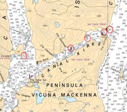
The layout was designed to consider the three constrictions and both entrances to the channel. The main constriction is the Kirke Narrow located at the eastern end of the channel (Figure 2).
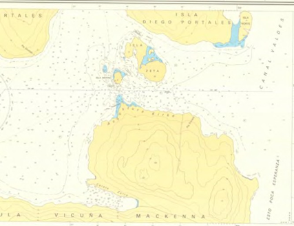
In this location, the main variations of the tidal wave were observed and required an additional three temporary sensors to be installed for a shorter period (24 hours). This improved the precision of the measurements in the choke zone, close to the eastern entrance between Punta Entrada and the access to the Mal Paso passage. In this location the observed tidal wave was of similar characteristic to that observed close to Isla Norte, but different from that observed close to Isla Zeta. This indicated that the phenomena are developed due to the constrictions between Islas Zeta and Merino with the coast of Isla Diego Portales and the Peninsula Vicuña Mackenna respectively (Figure 3).
A harmonic analysis was conducted using the observed data to determine the tidal harmonic constituents for the sites and the tidal wave was characterized according to the tidal regime. Also a forecast was calculated and registered values were compared with historic data for Punta Restinga. The results were similar for the tide for Isla Zeta and Isla Norte and that in this sector, the choke is produced and affects the narrow. The observations located to the west (Islote Julia, Isla Espinosa and Isla Medio Canal) demonstrated that the tide experiences a progressive attenuation in its range, without presenting significant changes to the phase (Figure 3). From the harmonic analysis, a study of the non-linear component generated by sea-floor friction was conducted to determine if these impacted symmetric and asymmetric distortions of the tidal wave was conducted (Figure 4). Based on the established relations it was verified how these distortions take place in the channel.
From the collected data, considerable variations were observed and sea level is significantly influenced by atmospheric pressure (Figure 5). Due to the importance of this vector in determining the range variability, the height observed, without atmospheric pressure corrections between the two entrances of the channel exists with an attenuation range of 1.35 metres and a mean phase gap of approximately 3 hours (Figure 6 and Table 1).
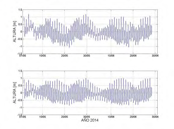
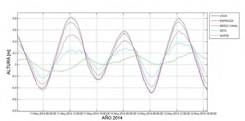
Figure 5. Isla Julia sensor observations: Tidal wave (upper part) and data corrected with atmospheric pressure information (lower part) 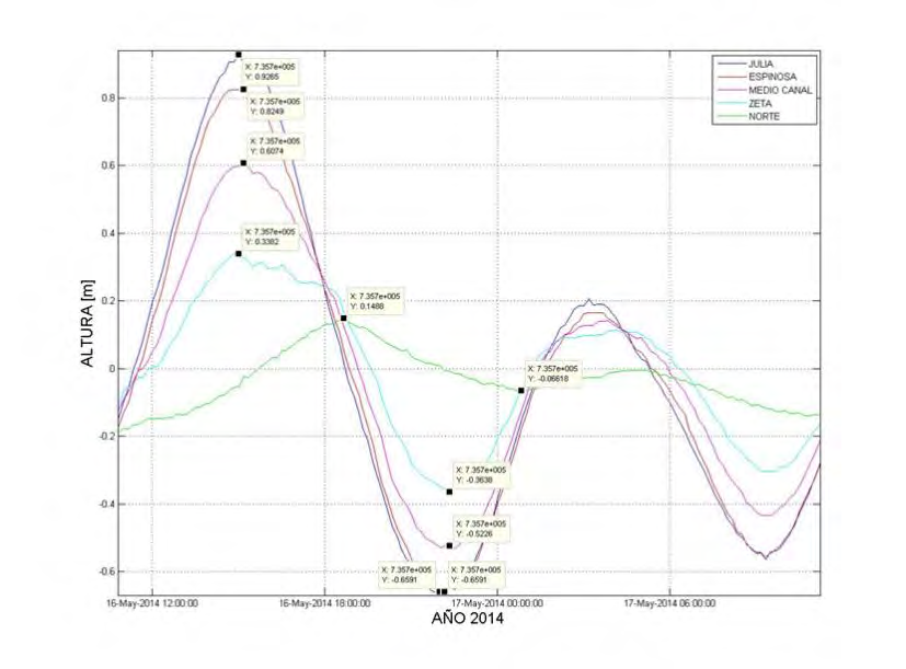
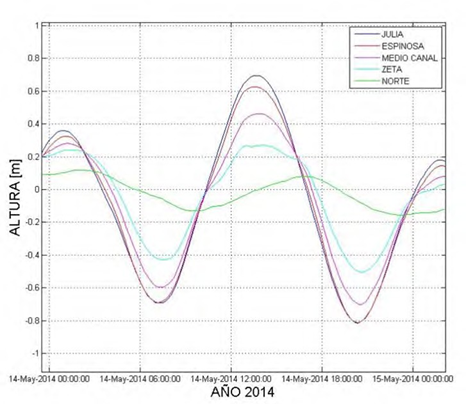
Figure 6. Tidal wave registered with maximum and minimum height values for each sensor defined as variable “y” (16th and 17th May)
| Date | High or Low | JULIA | ESPINOSA | MEDIO CANAL | ZETA | NORTE |
| 03 May | H | 16:20 | 16:20 | 16:20 | 18:40 | 21:30 |
| 04 May | H | 17:30 | 17:30 | 17:40 | 19:10 | 20:40 |
| 06 May | H | 20:20 | 20:30 | 21:00 | 21:10 | 22:30 |
| 12 May | H | 12:20 | 12:10 | 12:20 | 12:40 | 13:50 |
| 15 May | L | 20:50 | 20:50 | 20:40 | 20:50 | 23:10 |
| 16 May | H | 02:20 | 02:30 | 02:40 | 02:20 | 04:40 |
| 25 May | H | 11:40 | 11:50 | 11:50 | 11:50 | 14:50 |
| 27 May | H | 12:50 | 12:50 | 13:10 | 13:10 | 16:30 |
6. Conclusions
Kirke Channel has several constrictions that create a tidal pattern generating anomalies in the characteristics, ranges and phases of the tide. The most significant effect is produced by the constriction that exists in the vicinities of Isla Zeta and Isla Merino at the eastern end of the Kirke Channel. At this location, the greater gap is produced and there is a notable attenuation of the tidal range. The wave in this sector is distorted due to the effect of the sea-floor friction which was determined from the non-linear harmonic constituents. Despite the distortions that the wave presents along the channel, this wave is classified as a semidiurnal mixed tide regime, along its entire extension. It was also observed that the atmospheric conditions, particularly the atmospheric pressure have considerable influence along the Channel.
6. Author biography
Lt Matías I. Sifón graduated from the Chilean Naval Academy in 2008. Following different postings, he was selected to undertake the Hydrographic and Oceanographic Engineer Course for Officers, recognized as Cat ”A” in SHOA. After graduation, he participated in hydrographic surveys as Leader of the Hydrographic Teams. Since 2017, he is the Head of the Hydrographic Department at SHOA, responsible for the planning, execution, processing and production of nautical charts.