


1. INTRODUCTION
Bathymetry underpins the safe, sustainable, cost effective execution of nearly every human activity at sea. Yet, despite the multitude of data that have been collected over the last two hundred years, roughly twenty percent of the world’s ocean depths have been measured with direct observation and shared with the global community (GEBCO_2021). The rest of the data used to compile seafloor maps are estimated depths largely derived from satellite gravity measurements, which can miss significant features and provide only coarse-resolution depictions of the largest sea- mounts, ridges and canyons. Progress in mapping coastal waters is only marginally better. IHO publication C-55, Status of Surveying and Charting Worldwide, indicates that about fifty percent of the world’s coastal waters shallower than 200 meters remain unsurveyed to modern standards.
While the hydrographic and scientific community lament this lack of data, the world’s interest in seas, oceans and waterways continues to increase. The concept of a sustainable growing blue economy is firmly established, along with an ever-growing public awareness of mankind’s dependence upon, and vulnerability to, the sea. Several high-level global initiatives are now in place that seek to address ocean issues, including the United Nations Decade of Ocean Science 2030 Agenda for Sustainable Development Goals, the Paris Agreement under the United Nations Framework Convention on Climate Change, the Sendai Framework for Disaster Risk Reduction 2015-2030, and The Nippon Foundation-GEBCO Seabed 2030 Project.
The IHO has a history of encouraging innovative and collaborative ways to gather data and data maximizing initiatives so that we can better understand the bathymetry of the seas, oceans, freshwater navigable waterways and coastal waters. In 2014, the IHO, at its Fifth Extraordinary International Hydrographic Conference, recognized that traditional survey vessels alone could not be relied upon to solve data deficiency issues and agreed there was a need to encourage and support all mariners in an effort to “map the gaps.” One outcome of the conference was an initiative to support and enable mariners to collect crowdsourced bathymetry (CSB).
The IHO defines CSB as the collection of depth measurements from vessels, using standard navigation instruments, while engaged in routine maritime operations. The information, adequately categorized with respect to quality, would be used to supplement the more rigorous and scientific bathymetric coverage undertaken by hydrographic offices, industry, and researchers around the world.
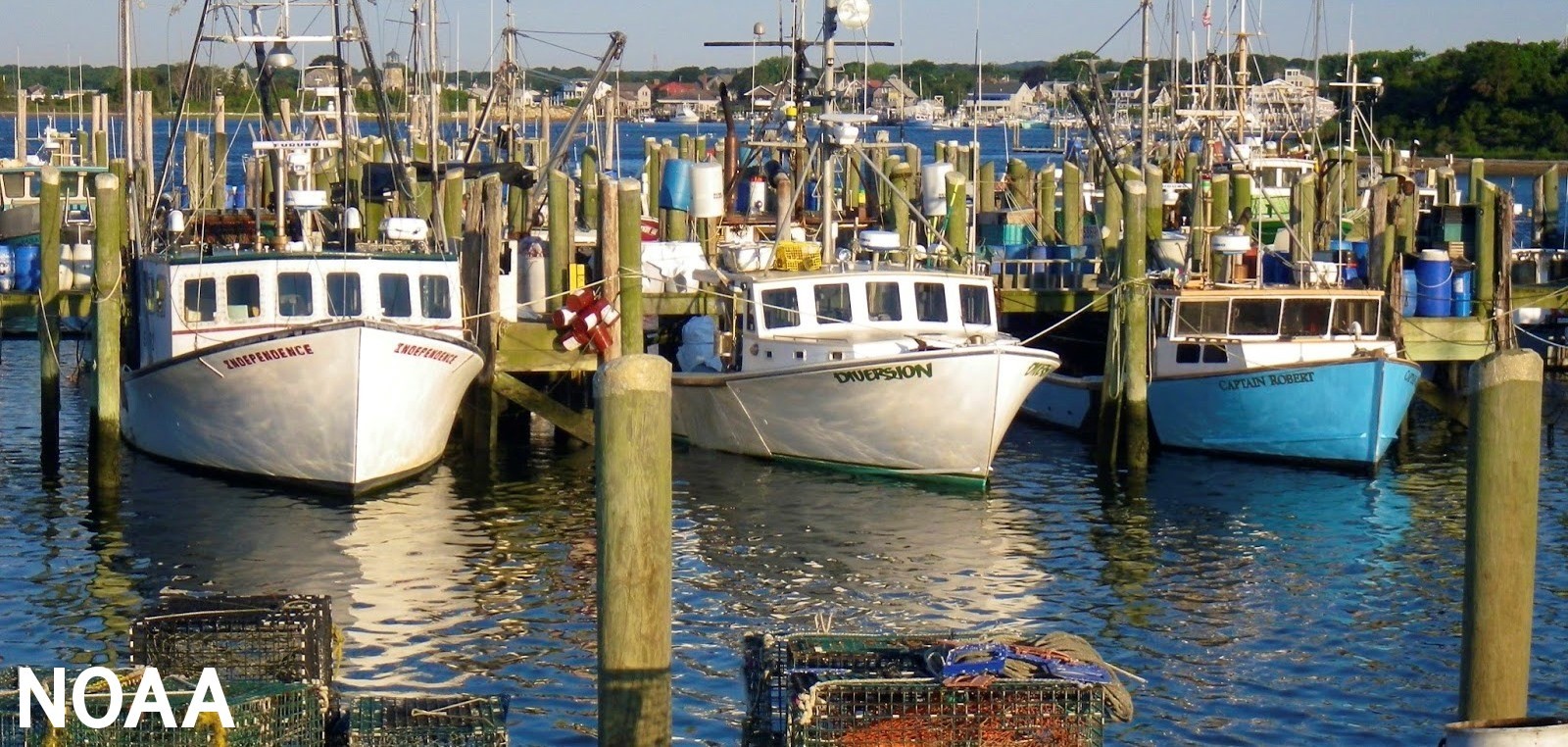
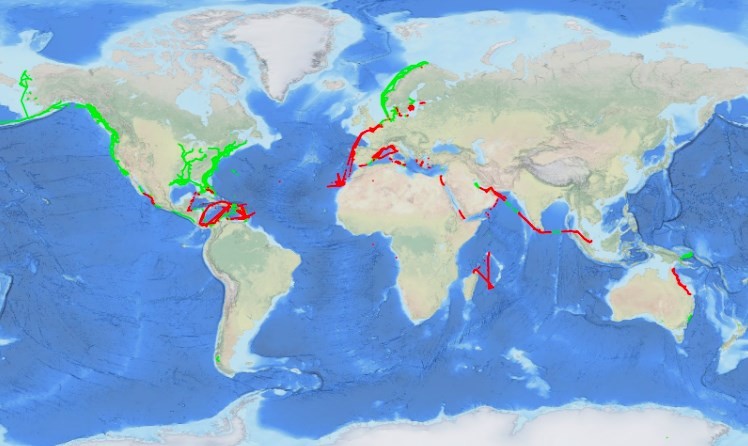
The key to successful CSB efforts is volunteer observers who operate vessels-of-opportunity in places where surveys are poor, inadequate, non-existent or where the seafloor is changeable and hydrographic assets are not readily available (Figure 1). The International Convention for the Safety of Life at Sea (SOLAS) 1974 carriage requirements oblige all commercial vessels to be equipped with certified systems consisting of at least a single beam echo-sounders and satellite- based navigation systems. As a result, the world’s commercial fleet represents a significant un- tapped source of potential depth measurements. Even most non-commercial ships and boats are equipped to measure and digitally record their depth in coastal waters and an ever-increasing number of vessels can also take measurements in deeper water with more affordable and accurate systems than could previously be achieved. The CSB vision is to tap into volunteer enthusiasm for mapping the ocean floor and coastal zones. Enabling trusted mariners to easily contribute data will augment current bathymetric coverage and enhance surveying and charting capabilities of the bathymetric initiative.
2. VALUE OF CSB
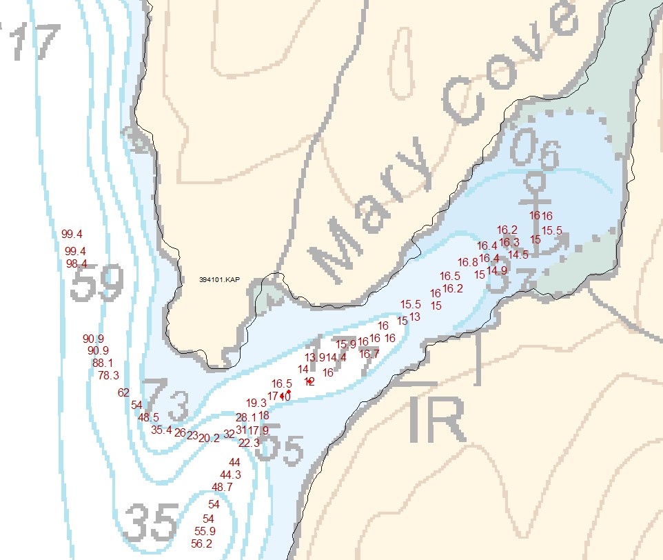
While CSB data may not meet accuracy and precision requirements for charting areas of critical under-keel clearance, it does hold limitless potential for a variety of other uses and to detect hazards to navigation. If vessels collect and donate depth information while on passage, the data can be used to identify uncharted features, assist in verifying charted information with appropriate category zones of confidence, and to help confirm that existing charts are appropriate for the latest traffic patterns (Figure 2). This is especially relevant considering that many soundings on charting products are pre-1950. In some cases, CSB data can fill gaps where bathymetric data are scarce and even non-existent, such as unexplored areas of the polar regions, around developing maritime nations, and the open ocean. CSB also has potential uses along shallow, complex coastlines that are difficult for traditional survey vessels to access. These areas may be more frequently visited by recreational boaters whose data could help illustrate seafloor and shoaling trends from the repeated trips they make along their favorite routes. Finally, crowdsourced bathymetry can provide vital information for reconnaissance and planning purposes to support national and regional development activities and scientific studies in areas where little or no other data exists and accurate hydrographic surveys are not a priority.
3. IHO CROWDSOURCED BATHYMETRY WORKING GROUP (IHO-CSBWG)
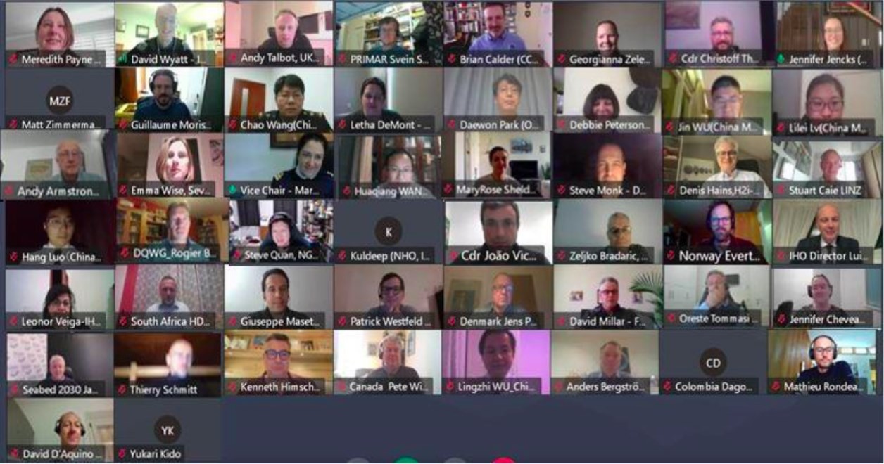
Another outcome of the Fifth Extraordinary International Hydrographic Conference was to establish an IHO Crowdsourced Bathymetry Working Group (CSBWG) (iho.int/en/csbwg). The IHO CSBWG, composed of international scientific, hydrographic and industry experts, was tasked to draft a guidance document meant to empower mariners to collect and contribute CSB data (Figure 3). This document describes what constitutes CSB, the installation and use of data loggers, preferred data formats, and instructions for submitting data to the IHO Data Centre for Digital Bathymetry (DCDB). The document also provides information about data uncertainty to help data collectors and data users better understand quality and accuracy issues with CSB. Thirty five of the ninety five IHO Member States supported the adoption of Edition 2.0.0 of B-12 IHO Guidance on Crowdsourced Bathymetry (IHO Circular Letter 28/2019) and are proactively supporting its maintenance and improvement. It is worth noting that this document provides technical guidelines only that in no way supersede national or international laws and regulations.
B-12 has now been in circulation for over two years and, apart from including feedback from operational use and experience, there is a strong desire to make the document more “equipment agnostic” with the intent of soliciting data from all sources, not just single beam echo sounders. The CSBWG intends to circulate an updated version to MSs for comment in 2022.
In addition to maintaining and updating B-12, the working group is also positioned to investigate and highlight use cases of CSB data, provide guidance on data quality and standards in liaison with the IHO Data Quality Working Group and consider incentives to increase data contributions by mariners. The CSBWG is particularly tasked to work in cooperation and coordination with other IHO bodies and relevant industry stakeholders to ensure a harmonised approach to data gathering and the resultant datasets. Finally, the working group is discussing ways to encourage all vessels engaged at sea that are equipped with appropriate technology, to collect bathymetric data as part of their normal operations – in the same way that mariners currently and routinely observe the weather and make other marine environmental observations.
4. CONTRIBUTING AND ACCESSING CSB DATA
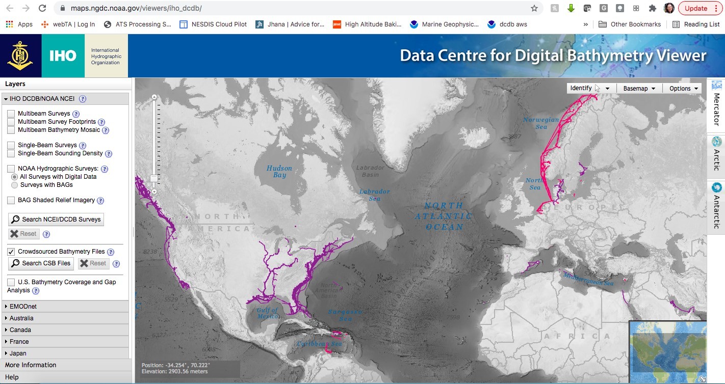
Under the guidance of the IHO Crowdsourced Bathymetry Working Group (CSBWG), the National Oceanic and Atmospheric Administration (NOAA) has volunteered to provide archiving, discovery, display and retrieval of global crowdsourced bathymetry data contributed from mariners around the world. These data reside in the IHO’s Data Centre for Digital Bathymetry (DCDB), hosted by NOAA’s National Centers for Environmental Information (NCEI), which also offers access to archives of oceanic, atmospheric, geophysical, and coastal data (Figure 4).
Crowdsourced bathymetry enters the DCDB through a variety of trusted sources or nodes (e.g. partner organizations, companies, academia and non-profit groups) that enable mariners to voluntarily contribute seafloor depths measured from their vessels. Rose Point Navigation Systems, a provider of marine navigation software, helped establish the stream of data from a crowd of mariners. Specifically, users of their software were given the option to enable logging of their position, time and depth. Users were then given the choice to submit their data anonymously or provide additional information (vessel or instrument configuration) to enrich their dataset.
The intent is that these data, like all bathymetric data submitted to the DCDB, would not necessarily be “harmonised” or reviewed but would reside in the DCDB “as is.” It would remain up to the end users to determine their value and utility for their own purpose. In this way, the fundamental data that reside in the DCDB are intended to serve as the world reference raw bathymetric data set which can be used as the basis for refined and processed products.
5. COASTAL STATE SUPPORT OF CSB DATA PROVISION
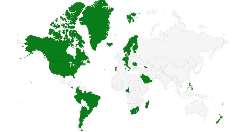
In 2019, IHO CL 11/2019 was published calling for the approval of IHO Publication B-12. The letter also sought support for the CSB initiative and data gathering activities, not only in deep ocean regions but also within the waters of national jurisdiction of individual coastal states. Only fifteen member states provided positive responses to the request. The DCDB responded by implementing a mechanism that filters out incoming data from coastal countries that responded either negatively or did not reply at all (Figure 5). The IHO and the CSBWG believe that the lack of initial responses indicated that the circular letter was not clear and complete.
In 2020, a second circular letter, IHO CL 21/2020, was issued. Instead of asking member states if they accepted “CSB activities” in their areas of jurisdiction, the revised questionnaire sought to gain support for the provision of CSB bathymetry data gathered by ships within waters under national jurisdiction, rather than the data being kept on board or deleted. The letter starts from the position that CSB is being and will continue to be gathered, regardless of an individual coastal states position. So the question becomes – can that data be databased and made available for wider uses with necessary metadata as cautionary notes?
Realizing that IHO CL 11/2019 did not provide an opportunity for non-IHO member states to provide their position on the subject, an Inter-Regional Coordination Committee (IRCC) CL 1/2020 was written to the chairs of the regional hydrographic commissions (RHC) requesting they encourage all RHC coastal states to respond with their positions as well. To date, it is encouraging to see that 30 coastal states have replied positively (Figure 6). The DCDB will update the geographic filter this year to reflect updated coastal state positions. It is hoped that all CSBWG members will reply positively and many more MSs will join the CSBWG as active members.
6. CHALLENGES OF CSB
Since the issuance of IHO CL 11/2019, there has been coastal state opposition to the collection and public availability of CSB data collected in waters under national jurisdiction. While a number of coastal states objected to both CLs without providing any reasons for their objections, several did provide explanations to their negative positions.
The following are the general reasons given for negative responses to CL 11/2019:
I. No Multi Beam Echo Sounder (MBES) data collection in Territorial Waters (TTW) unless a request has been sent and approval received;
II. Not considered and no plans to do so in near future;
III. Bathymetry in territorial waters are in general classified information and therefore crowdsourced bathymetry within territorial waters is prohibited by law;
IV. Majority of the Exclusive Economic Zone (EEZ) already, or will be, surveyed in near future in accordance with the IHO S-44 standard, therefore no need for CSB;
V. National HO is the only authorized organization to collect and store bathymetric data with the aim of chart production and bathymetry modelling within the national waters of jurisdiction;
VI. Bathymetric surveys for knowledge or exploitation of the marine environment are regulated by national legislation in accordance with the United Nations Convention on the Law of the Sea (UNCLOS), these data can only be used by the DCDB and in a digital terrain model after validation by the national HO, the cartographic exploitation of this data is also the responsibility of national HO;
VII. No added value of CSB in national waters, which are already surveyed to the highest standards to assure safe navigation;
VIII. Support for unrestricted CSB only along traditional shipping routes and transit passages;
IX. Data resulting from CSB activities as gridded data sets or as raw data will only be available after analysis and authorization of the national HO;
X. In accordance with national law covering survey activities in waters of national jurisdiction, all activities for the acquisition of any bathymetric data undertaken by all vessels can only be conducted after prior authorization of the relevant government departments;
XI. The national HO must check CSB data acquired in water of national jurisdiction before being forwarded to the DCDB, any data thus forwarded can be disseminated only after approval from the national HO;
XII. Bathymetric measurements for the knowledge or exploitation of the marine environment in waters of national jurisdiction, which includes territorial waters and continental shelf, and is regulated by national laws in accordance with UNCLOS, will be provided exclusively by the national HO; and
XIII. Data under the IHO CSB concept is restricted in accordance with national regulations, it is prescribed by national regulations; lawfully collected bathymetric data can be made available for use only by signing a license agreement.
The following are the general reasons given for negative responses to CL 21/2020:
I. National HO is the sole competent authority for bathymetric data provision within waters of national jurisdiction;
II. MBES is allowed only after prior consent of the national HO, complete datasets should be shared with the national HO in full;
III. No MBES activity without prior permission, copy of dataset must be provided to the national HO;
IV. Support for CSB data provision from the waters of the IHO members states which have not achieved full survey coverage; will not use CSB data because waters fully covered systematic surveys;
V. According to national regulations the performing of scientific research, any study and survey of the sea, seabed or its subsoil or performing other underwater activities in the waters of national jurisdiction is only permissible on the basis of a prior approval to be issued by the relevant government authorities;
VI. Any foreign organization, foreigner or national with an intention of carrying out CSB activities in waters of national jurisdiction must obtain authorization from the relevant government authority. No MBES activity in the waters of national jurisdiction is allowed without prior permission;
VII. According to the national legislation bathymetry is classified in the internal and territorial sea, so CSB is prohibited;
VIII. Opposed to the free use of this data from the waters of national jurisdiction without the express consent of the relevant Coastal State;
IX. Only for areas of 200 m depth or greater; and
X. All EEZ areas have been surveyed to IHO S-44 Edition 5 Order 1a.
It is clear from many of the negative responses received above that there remains confusion between the intent of CSB data gathering, planned scientific data gathering and systematic hydrographic survey operations. It is important to stress further that the focus of the CSB initiative is to collect data in poorly surveyed or unsurveyed areas and to share the data openly for better knowledge and understanding of the seabed. In the case of areas well surveyed, newer data can still add value, whatever the quality, as it can highlight recent changes to the seafloor and around ever-evolving coastlines as well as indicate that the published data is still valid and no re-survey requirement exists. The IHO and CSB Working Group is willing to engage in as many bilateral conversations as necessary with HO MSs to investigate how to increase the level of comfort to join the WG and promote CSB. It is hoped that increased awareness and information as well as continued stakeholder engagement and involvement will help to overcome these reservations, due to both perceived and real issues.
7. CONCLUSION
The success of a global initiative is always dependent on the level of leadership, commitment and activities of the MSs. The IHO invites all HO MSs to consider (1) responding positively to IHO CL 21/2020 and IRCC CL 1/2020, (2) harnessing their own fleets (eg. Coast Guard, academic, Navy) using CSB data collection techniques by default and (3) for the MSs not yet members of the CSBWG to join the group. Crowdsourced efforts and the crowdsourced bathymetry database are poised to become a major source of information for a better knowledge and understanding of our blue planet. They are not only improving nautical chart coverage and accuracy, but contributing to international mapping efforts such as The Nippon Foundation-GEBCO Seabed 2030 Project and thus directly supporting a number of UN initiatives. These data have the potential to become critical resources for coastal zone management and environmental and scientific studies, the marine spatial data infrastructure, the expansion of hydrography towards hydrospatial and particularly in areas of little perceived commercial or strategic value.
This is in line with the IHO strategic plan objectives approved by IHO Assembly (A-2) in December 2020 and in particular with the IHO Strategic Goal 3: “Participating actively in international initiatives related to the knowledge and the sustainable use of the Ocean” and the correlated target focused on improving the “knowledge of the world’s seafloors”. Engaging in CSB does not only mean to provide data or to have access to seabed information but to contribute to spreading the message of global responsibility in order to reveal the deep and fill the existing gaps in mapping the ocean.
All IHO MSs are encouraged to contact the Authors for more information about the CSB initiative and the CSBWG; and for those who are not members of the CSBWG to commit to this important initiative and be part of the leadership to enable and to engage in: “Citizen Sourced Data – Help Reveal the Deep and Share Your Data!”
8. REFERENCES
GEBCO_2021 Grid, www.gebco.net, May 2021.