

Abstract
1. INTRODUCTION
Electronic navigation consists of defining the position and controlling the ship by any kind of electronic system or equipment (Miguens, 2019) on board of almost every ship, no matter their size or type. For such a task, there are many platforms that can integrate several systems with ship capabilities.
SOLAS (Safety of Life at Sea) vessels, such as merchant ships, use the ECDIS (Electronic Chart Display Information System), an electronic system that integrates information from various sensors, for navigation and visualization of nautical charts. ECDIS works with ENC (Electronic Navigational Charts), which are official nautical charts produced by Hydrographic Offices all around the globe, in accordance with the guidelines and technical specifications established by IHO (International Hydrographic Organization). ENCs are used globally and regulated to permit data transfer between Hydrographic Offices and sailors.
ENCs are databases which contain all information available on paper nautical charts and they can have additional data that might help navigators. ECDIS can interact with ENC features, allowing, inside rigid regulations, to customize the visualization of electronic chart features and also the querying of ENC details and features. Once ECDIS receives information from many sensors, such as the gyro, GNSS (Global Navigation Satellite System), radar, and so forth, all of these data are integrated and shown in a single console, which contributes to safety of navigation.
IHO, as regulator of hydrographic standards for safety of navigation, published the ENC standards. Today, the S-57 standard is the one authorized for use. This standard was developed in the 80’s, and ENC production was gradually implemented over the last three decades. ENCs also meet the requirements of Rule 9, Chapter V, of the Safety of Life at Sea regulations.
Due to the progress of technology over the last decades and the establishment of geospatial data standards by the OGC (Open Geospatial Consortium) and ISO (International Organization for Standardization), S-57 standards have become outdated. Also, hydrographic data should be used not only for navigational purposes, but also to integrate other geospatial data. For that reason, IHO has recently published S-100 (IHO Universal Hydrographic Data Model), which will easily, simply and safely enable it to integrate data of several kinds, such as high-resolution bathymetry, meteorology, tides, and so on, aiming at navigation safety.
In parallel, the International Maritime Organization (IMO) has processed the concept of e-Navigation, which consists of “the harmonized collection, integration, exchange, presentation and analysis of marine information on board and ashore by electronic means to enhance berth to berth navigation and related services for safety and security at sea and protection of the marine environment”, as defined by IMO (2020). The concept of e-Navigation provides that, for the integration of information, S-100 products are used.
There is now then be a need to transition from the products and services currently made available to sailors to the new S-100 standard. This implies that hydrographic services will start making available the new S-100 products, according to a schedule to be set by IHO and other international associations, such as the World Meteorological Organization (WMO) and the International Association of Lighthouse Authorities (IALA). In the specific case of ENCs, it must be mandatory, according to the standard that specifies the new product, the ENC S-101 (ENC Product Specification).
As with any transition, it is necessary to provide and support for both, the new and the old product, concomitantly. As such, Hydrographic Services will have to produce the ENCs under their responsibility in accordance with both standards for a long period of time, until IHO and IMO define a deadline for the availability of all S-101 ENC and the installation of S-100 ECDIS compatible with new products and services, on all SOLAS vessels. The other organizations, such as WMO and IALA, will also be in line with these changes, setting deadlines within their competencies. In the case of ENCs, the need for production, updating and concomitant support for the two standards (S-57 and S-101) will require a major development and production effort for Hydrographic Services.
IHO, being aware of the effort needed for a change of this size, requested Environmental Systems Research Institute (ESRI) and the National Oceanic and Atmospheric Administration (NOAA) to develop a converter. This converter is intended to transform the data from the S-57 standard into the new S-101 standard. After the creation of this software, IHO itself has encouraged that it be tested, and it is currently distributed free of charge by ESRI.
Thus, this article aims to test the converter provided by IHO / ESRI / NOAA partnership, for the conversion of navigation charts in the S-57 standard into S-101. Due to the simple fact that the update of standards is complicated, it has been anticipated that some S-101 ENC features will not be perfectly contemplated by the conversion of the ENC S-57 features, which will require manual work of data coding and / or additional attributes.
2. LITERATURE REVIEW
The ENCs currently used follow the guidelines established in the S-57 standard, which have been used for a long time. Companies have manufactured and produced systems capable of interpreting and presenting the ENC S-57 data. These systems, called ECDIS, have been improved and updated, in order to currently achieve the most modern and technological level in terms of navigation, by integrating several systems and consoles in a single piece of equipment capable of managing all this information.
ECDIS are able to gather information from several sensors available in just one equipment, which, in turn, is able to gather all these data and present it to the navigator in accordance with the specific standards set by the International Electrotechnical Commission (IEC) and other organizations. ECDIS can also perform calculations and projections, make markings on the screen, alert the user of dangers through alarms, monitor contacts, present various information layers, such as radar and Automatic Identification System (AIS), among several other additional features, inherent to each equipment from each manufacturer.
The S-100 standard, in the scope of e-Navigation, comes in line with the thought of insertion capacity and presentation of layers made possible by the current ECDIS. The future S-100 ECDIS will have the ability to provide the user with the application and presentation of several layers, based on the ENC S-101. Beyond the S-101 ENC, it will be possible to use the other products of the S-100 family, such as Water Level Information for Surface Navigation (S-104), Surface Currents (S-111), Navigational Warnings (S-124), Under Keel Clearance Management (S-129), Weather Overlay (S-412), among others.
As for the development of new equipment and systems capable of working with the S-100 products, the Korean Hydrographic and Oceanographic Agency (KHOA) has been testing systems for visualization of the S-101 ENC together with other S-100 products, since 2017, in order to contribute to the development of standards for the use of S-100 products in future ECDIS.
According to the report issued by KHOA, the ECDIS prototype test was conducted by members of the hydrographic services of the United States of America, United Kingdom and Canada (Korean Hydrographic and Oceanographic Agency, 2017). Also, according to this report, the test was carried out between Busan and George Islands in the Republic of Korea, on board of the KHOA research ship called Hae Yang 2000 and tested ten 1 S-100 standard products.
As the main comments made by KHOA, it has emphasized that it is necessary to harmonize the presentation of data by the navigation system. They also warn that if the development and presentation of the products are done in isolation, there will be a lot of information on the screen, causing the need for collaboration between the working groups responsible for the development of the various S-100 products.
On the other hand, within the scope of the S-100 production, Teledyne Caris has published a new version of the Caris HPD 4.0 software that is capable of working with S-100 products. According to the company, the program is able to edit and work concurrently with the two information standards and create ENC of the S-57 and S-101 standard.
Although there is already a functional ECDIS prototype, many tests and developments are still necessary, mainly in the matter of data presentation, in order to be able to reach a safe and reliable level according to the established safety standards. Only in this way can the new S-100 standard be properly used.
Finally, this study meets the scope of the tests recommended by IHO, for the conversion of ENC S-57 into ENC S-101.
3. METHODOLOGY
In the development of this study, the converter developed by ESRI, version 1.0.0.20, will be used. It is expected that the program can convert most objects and attributes. However, as the software is not fully functional and not all S-57 data has a direct S-101 equivalent, there will be a need to analyze and process the converted data to verify the consistency and reliability of the conversion.
The conversion by the program generates log files with warnings, errors and information about the conversion process. ENC S-57 will be converted and subsequently analyzed, based on the records, to verify the errors that had occurred and possible causes and solutions, thus enabling full compatibility of the new ENC S-101.
The types and quantity of warnings, errors and other information will be taken into account so that they can be qualified and quantified. After that, causes will be analyzed so that changes can be suggested and the necessary corrections are made.
This study has been carried out in partnership with CHM (Brazilian Navy Hydrographic Center), which provided a sample of coastal, approach and port ENCs to be converted. The ENCs chosen cover the area between the Port of Santos, in the state of São Paulo, and Vitória / Tubarão, in the state of Espírito Santo, passing by the coast of Rio de Janeiro. Due to the scales of these ENCs, some have a wide scope and others have a great wealth of data depending on the geographic region. In addition, they represent an important area for maritime navigation and economic development in Brazil.
Table 1 lists the ENC that have been used and converted in the course of this study.
Table 1 : ENC used.

4. IHO S-57 AND S-101 STANDARDS
This chapter will focus on briefly describing and outlining the structure of the S-57 data, in order to familiarize the reader with this type of data, and so allow a better understanding during the analysis of the results obtained in this study. It should be noted that, during the development of Chapter 4, all information will be based on the publications that govern the ENC S-57 and S-101 standards.
According to IHO, the S-57 standard has been developed in order to allow the transfer of data that describe the real world, in a simplified but very specific way (International Hydrographic Organization, 2000). Specificity is based on the need to keep the necessary data under control and to model only the information relevant to hydrography.
In order to model the real world, IHO defined two main types of data – objects and attributes. As defined by the IHO, objects are an identifiable set of information. Objects can have attributes and can be related to other objects. They were further divided into two types, “feature” and “spatial”. The feature object contains the non-locational information. On the other hand, spatial objects can contain locational information about real world entities.
Although the new information standard S-101 maintains the same data structure of objects and attributes, the newer standard has a different approach in that S-101 attributes can be either simple or complex. Table 2 lists the seven types of S-101 simple attributes.
Table 2 : Types of S-101 simple attributes.

Complex attributes are defined as an aggregate of simple and / or complex attributes. This junction occurs through links between the attributes.
Another major difference between the two patterns is the correlation between objects and attributes. Some correlations have remained the same, but others have been completely changed. In some cases, there is a need for total remapping of the object and its attributes and in other cases, the attributes have been remodeled.
As a semantic case, the new RESARE (Restricted Area) may or may not be linked to navigation. A good example is the case of restricted areas for activities related to navigation (Restricted Area Navigational) or for other activities, which do not directly interfere with navigation (Restricted Area Regulatory). Both are coded with the acronym RESARE.
For example, to define a prohibited fishing area in the S-57 standard, a RESARE – Restricted Area – must be defined and assigned to its RESTRN – Restriction attribute – the value “3-Fishing Prohibited”. On the other hand, according to Annex A of S-101 (IHO, 2018), the S-101 Codification Guide (DCEG – Data Classification and Encoding Guide) – Annex A of S-101 Standard, a RESARE (Restricted Area Regulatory) must be defined and assigned to attribute RESTRN (Restriction) with the value “3-Fishing Prohibited”.
In ENC S-57, RESARE is defined as an area designated by an appropriate authority within which navigation is restricted in accordance with certain specified conditions, that is, by definition this type of area is intended only for navigation restriction, although the attribute RESTRN make it possible to restrict a fishing area, for example. In this case, where the only restriction is fishing, ECDIS would treat the area in the same way as an area where navigation was restricted. On the other hand, in S-101 ENCs these codifications are separated and make it possible to treat areas restricted to navigation or restricted areas in different ways.
5. DISCUSSION OF S-57 AND S-101 ENCS COMPARATIVE STUDY
The standards established for the S-57 and S-101 ENCs, although they may seem very similar, have very significant differences, not only in terms of the structure of the data, but in terms of the metadata of each cell (ENC file). Since there are differences between these two standards, some changes should be made to all files, as described in the following items.
5.1 MAXIMUMDISPLAYSCALE AND MINIMUMDISPLAYSCALE
As a significant example, which should be carefully studied by the Hydrographic Services for the preparation of S-101 ENC, there is the attribute of minimum and maximum scale for the visualization of each cell.
Currently, in the S-57 standard, by the S-52 data visualization standard (International Hydrographic Organization, 2015), the visualization of the ENCs inside ECDIS obeys the purpose of use and the compilation scale of the cell, through the Compilation Scale (CSCL) metadata, which tells from which scale such a cell should not be used. Normally, the CSCL is the double of the ratio scale of the respective paper chart.
However, the S-101 requires that each dataset have the scale values individually configured, both for the maximum scale, corresponding to the old CSCL and the visualization scale from which ECDIS displays the overscale message, and for the minimum scale of display, from which the ENC starts to be visualized. This configuration is extremely important as it will guarantee the navigator the proper use of the S-101 ENC.
To better visualize the issue of the minimum and maximum scale, we have Figure 1 (International Hydrographic Organization, 2018). There are three different cells with different maximum and minimum scales, described in the first line. The drawing order in ECDIS is from left to right, starting with ENC “X”, then “Y”, and finally “Z”. The expression “Mariners Selected Viewing Scale (MSVS)” refers to the navigator’s viewing scale in ECDIS.

In the first condition, the MSVS is 90,000. As the minimunDisplayScale of ENC “X” is bigger than the MSVS it is not shown in this scale of visualization so it will not be presented to the navigator, but only the ENC “Y” and “Z”.

Subsequently, in condition 2, the MSVS equals to 45,000:

Thus, all cells will be displayed, with preference being given to “X”, of a larger scale, then to “Y”, and finally to “Z” of a smaller scale. In this last condition, where MSVS has a value of 22,000, we have:

Thus, the datasets “X” and “Y” are displayed normally and “Z” will also be displayed but with an alert that it is over scaled. Finally, it is suggested that the Hydrographic Services conduct studies on board of ships, so they will be able to choose the best scale for each dataset.
5.2 NAMING THE DATASETS
Another difference is in the pattern of file names for each cell. According to IHO (International Hydrographic Organization, 2018) the name of each cell must comply with the following standard:
101CCCC0000000000.EEE as explained below.
The first three characters – “101” – are mandatory, demonstrating that the file is an ENC S-101. The next four characters – CCCC – refer to the issuing entity of that ENC, coded according to the producer code, which can be between 2 and 3 characters long in the current S-57 standard and the missing characters can be completed with “00” or “0”. Then we have a sequence of zeros, which indicate a composition of at least 8 and at most 17 alphanumeric characters and / or the special character _ (underscore), in order to have a unique combination for each file. This opens up a range of new possibilities for existing encoding names.
Taking for example the Brazilian ENC 23100, which is currently named “BR323100.000”, it could become “101BR0000023100.000”. As a great possibility, it can be mentioned that the charts belonging to the waterways may carry their respective names or codes. For example, “101BR00AMnnnnnn.000”, where “AM” would indicate Amazon River and “nnnnnn” the chart number. There may be several other possibilities and possible combinations.
Finally, “.EEE” indicates editions and / or updates, “000” for new datasets and new editions and updates, starting from 001 to a maximum of 999. This is a mandatory element in cell names. And the new aspect is the possibility of updating cancellations, that is, an update that cancels the previous version of ENC and publishes a new one, using the same name. For example, if a Hydrographic Service needs to publish a new version of an ENC, it will no longer be necessary to withdraw the old ENC from circulation and publish the new version by a new name, it will simply be possible to publish a new ENC of the same name, with the format “.000”, which will then cancel the previous version and become the updated ENC, having the same name as the previous file.
Another difference is that in the new S-101 standard there will no longer be a need to include the purpose of use in the dataset nomenclature, so allowing hydrographic services more flexibility to name the cells.
So being, it is possible to verify some general changes that will affect the making of an ENC and its coding. As a result, all ENCs should be individually reassessed and studied for the change from standard S -57 into S-101.
5.3 CONVERSION RESULTS
Due to the results of the conversions, the program categorizes the errors into two types: “Warnings” and “Information”. Both types of errors are dangerous, as ENCs may no longer have important information for the sailor and thus compromise the safety of navigation. Thus, this study will address a possible solution throughout the analysis of the results.
Below, you can see Table 3 that relates each ENC with the types and number of errors present in each conversion.
Table 3 : Correlation between ENC and errors types

By analyzing Table 3, it can be quickly seen that there is no direct correlation between the total number of errors and the purpose of using each ENC. Another point that can be concluded is that the amount of “warning” is almost always higher than the amount of “info”.
After the conversion, 1,290 errors were verified, of which 163 were of the “info” type and the other 1,127 were of the “warning” type. The errors were filtered and grouped by similarity, so being 63 different error groups were obtained, even though they could be regrouped. At the end of the filtering, it was found that as much as the number of “warnings” was higher, many errors were repeated and thus greatly simplifying the analysis and correction of the data. Finally, there were only 20 “warning” and 43 different “info” errors.
In the following items, the main errors (info and warning) have been separated and classified by types, in order to facilitate understanding and improve the organization of this study and data resulting from the conversion.
5.4 “INFO” TYPE ERRORS
In this item, the “info” errors present in the compilation of all log files generated during conversions will be shown. Then they will be aggregated by similarity and possible solutions for a better understanding will be proposed. The title of each subsection is the error itself, and the causes and solutions will be shown in its development.
5.4.1 Attribute EXPSOU for feature SOUNDG dropped from S-101 feature Sounding.
In this error, the attribute EXPSOU – Exposition of Sounding – has been removed from the SOUNDG – Sounding object. According to DCEG, the EXPSOU attribute indicates objects in which the sounding value is outside the depth range where it is located. The publication itself points out that this attribute indicates objects that could be potential hazards to navigation.
Although this security feature has been removed from surveys, IHO draws special attention to this detail. Thus, DCEG recommends caution when encoding soundings that are shallower than the area depth variation of the area, since sounding values will not always be shown, depending on the user’s settings in ECDIS. This possibility is not exclusive to the S-101 and already existed on the S-57, however, as this attribute has been removed from the S-101, IHO has reinforced the importance of correctly coding, using other resources as available, the use of an obstruction area, which would not be hidden along with the sounding in the ECDIS configuration.
5.4.2 Attribute NATQUA for feature UWTROC dropped from S-101 feature UnderwaterAwashRock.
In this error, the NATQUA attribute – Nature of Surface-Qualifying Terms – has been removed from the UWTROC – Underwater / Awash Rock object. According to DCEG, the NATQUA attribute encodes the surface material in terms of its size, morphology and consistency. According to the decision of the S-101 Electronic Navigational Chart Project Team (S101PT), this attribute will no longer be necessary for the UWTROC object in ENC S-101.
5.4.3 Attribute QUASOU for feature SWPARE dropped from S-101 feature SweptArea.
For the SWPARE – Swept Area object – the QUASOU attribute – Quality of Vertical Measurement – has been removed. This attribute is about the reliability of a sounding value. According to IHO, this attribute will be inserted in the metadata M_QUAL – Quality of Bathymetric Data – which encodes the quality of bathymetric data for a given area (International Hydrographic Organization, 2019).
5.4.4 Attribute SCAMIN for feature BRIDGE dropped from S-101 feature SpanFixed.
This error occurred not only with the SpanFixed object, but also with the SpanOpening and COALNE – Coast Line object – and it means that the SCAMIN – Scale Minimum attribute has been removed from these objects.
According to IHO, the SCAMIN attribute defines the minimum scale that the referred object can be used (International Hydrographic Organization, 2018), as an example in the visualization through ECDIS.
Here is a brief explanation of how to code a bridge in the S-101 to better understand this error. According to IHO, when a bridge is coded on navigable water, the new standard must be made up from the BRIDGE – Bridge type object – together with other correlated objects (SpanFixed; SpanOpening; and PYLONS – Pylon / Bridge Support) through the association called “Bridge
Aggregation” (International Hydrographic Organization, 2018). The BRIDGE object by itself does not have a defined geometry, and its representation comes from geometry inherited from the objects present in its aggregation. In Figure 2, it is possible to verify a coding scheme for an “Opening Bridge”, that is, a bridge that is closed when it allows the traffic of cars and open to make maritime traffic possible.

Once the previous part of the process has been explained, the SCAMIN attribute will not be linked to each SpanFixed or SpanOpening object, but to the bridge as a whole encoded as BRIDGE – Bridge – and all of its pieces will be gathered through the configuration called “Bridge Aggregation”.
The converter was able to perform the conversion correctly. The “Presidente Costa e Silva” Bridge (also known as “Rio-Niterói” bridge) was converted into an aggregation of objects, of which the main one was the BRIDGE type, with the correct value for the SCAMIN attribute, which can be seen in Figure 3. The central span and lateral spans have been defined each as an object of the type “SpanFixed” with its respective attributes, and the rest of the bridge extension was divided into just two objects.

In Figure 4, it can be seen that the “Bridge Aggregation” was correctly assigned to the “Rio- Niterói” Bridge. And finally, in Figure 5 it is possible to see some of the elements that compose the “Bridge Aggregation” of the “Rio-Niterói” Bridge in the converted ENC S-101.


5.4.5 Attribute SORDAT for feature ACHARE dropped from S-101 feature AnchorageArea.
The attribute SORDAT – Report Date – in general, indicates the date when a feature was observed, completed or investigated.
This error occurred for the following objects: ACHARE – Anchorage Area; ADMARE – Anchorage Area; BOYINB – Buoy Installation; BOYSPP – Buoy Special Purpose / General; BRIDGE – Bridge; DEPARE – Depth Area; DEPCNT – Depth Contour; DMPGRD – Dumping Ground; LIGHTS – Light All Around; and RESARE – Restricted Area Navigational. According to IHO in general, this attribute has been removed from the S-101 (International Hydrographic Organization, 2019), remaining only in some objects.
5.4.6 Attribute SORIND for feature ACHARE dropped from S-101 feature AnchorageArea.
Again, this error occurred for several objects, which are: ACHARE – Anchorage Area; ADMARE – Anchorage Area; BOYINB – Buoy Installation; BOYSPP – Buoy Special Purpose / General; BRIDGE – Bridge; BRIDGE – SpanOpening; CTNARE – Caution Area; DEPARE – Depth Area; DEPCNT – Depth Contour; DMPGRD – Dumping Ground; DRGARE – Dredged Area; HRBFAC – Harbor Facility; LIGHTS – Light All Around; MORFAC – Mooring / Warping Facility; OBSTRN – Foul Ground; OBSTRN – Obstruction; PIPSOL – Pipeline Submarine / On Land; RESARE – Restricted Area Navigational; SLCONS – Shoreline Construction; SOUNDG – Sounding; and WRECKS- Wreck. According to a decision by S101PT, the SORIND attribute has been completely removed from the S-101. Therefore, this error does not generate any action necessary for its correction.
5.4.7 Attribute TECSOU for feature the SWPARE dropped from S-101 feature SweptArea.
The TECSOU – Technique of Vertical Measurement – attribute is no longer correlated with the SWPARE – Swept Area object. This attribute lists the possible survey methods that are used to obtain depth information. According to IHO, this attribute is no longer needed for the SWPARE – Swept Area object (International Hydrographic Organization, 2019).
5.4.8 Attribute VERCCL for feature BRIDGE dropped from S-101 feature Bridge.
Instead of what happened with the SCAMIN attribute on the BRIDGE object, the VERCCL attribute – Vertical Clearance -, which defines the vertical distance from the horizontal reference plane to the bottom of the feature in the real world, must be defined individually for each part of a bridge. Specifically, the VERCCL attribute must be encoded for each Span of a bridge. Thus, a thorough search should be made on all values for each span that composes a bridge for coding this attribute correctly.
This codification must be checked manually for each span of a bridge, since the ESRI converter may not correctly assign this attribute to each span individually.
5.4.9 Attribute VERCLR for the feature BRIDGE dropped from S-101 feature SpanOpening
This error is similar to the error in item 5.4.8. The VERCLR attribute – Vertical Clearance – is linked to the Span Fixed object, individually coded for each object of this type present on a bridge. The correction of this error is made the same way as in the previous item.
5.4.10 Attribute VERCOP for the feature BRIDGE dropped from S-101 feature Bridge
Exactly the same as the error in item 5.4.8, but with the VERCOP attribute – Vertical Clearance Open – which is linked to the vertical distance between the horizontal reference plane to the bottom of the feature when an “Opening Bridge” is open.
5.4.11 Enumeration code 9 (rock) dropped for attribute natureOfSurface for feature UnderwaterAwashRock
This error indicates that the value “9-rock” of the attribute NATSUR – Nature of Surface – was removed for the object UWTROC – Underwater / Awash Rock. According to the decision by the S101PT, the NATSUR attribute no longer has the value “9-Rock” for this object on the S-101.
5.4.12 Feature CTRPNT dropped from S-101
The object CTRPNT – Control Point – was removed from the S-101. In the S-57 standard, the CTRPNT object is defined as a point on land at which the position, both horizontal and vertical, is known and used as the basis for a survey. In the S-101 standard, this object has been remodeled to LNDMRK – Landmark – and is defined as any prominent object in a fixed position on land that can be used to determine a location or direction. This definition is more comprehensive and allows other functions for each LNDMRK. Thus, each case must be studied individually to verify the correct suitability of the points.
5.5 “Warning” errors type
This item will have the same approach that was given to item 5.4 and its subitems. In general, this type of error is linked to the identification number (ID) of each object that generated the error message. Caris editors have a tool to select objects by their ID, so it is possible to generate a list of objects with their respective ID and select them directly on Caris and manually correction of each one, thus facilitating the work of correcting the objects errors.
5.5.1 Unable to copy support file “PRESIDENTE COSTA E SILVA BRIDGE” referenced in NTXTDS for feature FE0000000900. File not found at path “C:/Users/Guilherme/ Documents/ENC/ENC S-57/BR501511”
This error occurred with all external description files present in the ENC directories. The NTXTDS attribute – Textual Description in National Language – encodes the name of the file external to the cell that contains a description in the national language. It was not possible to verify the cause of the error, but possibly there was some kind of discrepancy between the name of the external files. Therefore, it will be necessary to encode and configure each external file, individually, in ENC S-101.
5.5.2 Unable to map attribute EXPSOU for OBSTRN to FoulGround. Alias value not found in Feature Catalog.
“Foul Ground” is a safe area to navigate, but it should be avoided for anchoring, taking the ground or ground fishing. The coding of this type of area has changed, now it must continue coding with the acronym OBSTRN – Foul Ground – but with the different attributes of an OBSTRN – Obstruction.
The converter should be able to make this change automatically. Apparently, due to an inconsistency in the database, this object cannot be converted correctly, and its information must be verified and encoded manually.
5.5.3 Unable to map attribute PILDST for PILBOP to PilotBoardingPlace. Alias value not found in Feature Catalog.
In addition to the PILDST – Pilot District – attribute, the same error occurred with the NPLDST – Pilot District in National Language attribute. The attributes PILDST and NPLDST have been remodeled to an attribute of the Pilotage District object, with no direct correlation with the PILBOP – Pilot Boarding Place object. Similarly to the error in item 5.5.2, the converter should have made this correlation automatically. Apparently, due to an inconsistency in its database, this conversion was not performed, so it had to be encoded manually.
5.5.4 Unable to map S-57 enumeration code 1 (circular (non-directional) marine or aero-marine radiobeacon) for attribute CATROS for feature RDOSTA (BR000021604200133) to S-101 attribute categoryOfRadioStation for feature RadioStation
The conversion software was unable to assign the value “1-circular (non-directional) marine or aero-marine radiobeacon” to the attribute CATROS – Category of Radio Station. According to a decision by S101PT, it will no longer be necessary to code this value for the category of “radio stations” for nautical charts. The corresponding value will simply no longer be needed, nor will it be possible to encode it. Therefore, this error can be ignored.
5.5.5 Unable to map S-57 enumeration code 1 (directional function) for attribute CATLIT for feature LIGHTS (BR000019482300001) to S-101 attribute categoryOfLight for feature LightSectored
The CATLIT attribute – Category of Light – no longer has the value “1-Directional Function”. In order to code this same object on the S-101, an LIGTHS type object – Light Sectored – must be created and the Directional Character complex attribute must be configured according to the specific characteristics of the object’s light. It is suggested to read item 19.3 of the CDEG for a better understanding of the coding of a directional light.
5.5.6 Unable to map S-57 enumeration code 1 (permanent) for attribute STATUS for feature OBSTRN (CATOBS = 7) (BR000005256300001) to S-101 attribute status for feature FoulGround
Similarly to the error mentioned in item 5.5.2, in which the object OBSTRN was remodeled, in this error the object OBSTRN – Foul Ground – the attribute STATUS no longer has the value “1- Permanent”. Therefore, it is not possible to perform a direct correlation, and this value for this attribute will no longer appear on the S-101. So being, this error does not require additional actions by the encoder.
5.5.7 Unable to map S-57 enumeration code 3 (fishing prohibited) for attribute RESTRN for feature RESARE (BR000000062900001) to S-101 attribute restriction for feature RestrictedAreaNavigational
In the S-57 standard, the RESARE object – Restricted Area – had several values for the attribute RESTRN – Restriction –, which defines the types of restriction. In the S-101 standard, this object was remapped into two different objects, but with the same acronym of RESARE (RESARE – Restricted Area Navigational – and RESARE – Restricted Area Regulatory), so that the first encodes the areas of restriction to navigation and the former deals with areas with regulatory restrictions. By default, the software used converts S-57 RESARE objects to S-101 RESARE – Restricted Area Navigational. As the choice between an area restricted to navigation or regulation depends on the value of the RESTRN attribute, some values cannot be converted correctly.
For the reason explained above, the error described occurred not only with the value “3- Prohibited Fishing”, but also with the following values: “4-Restricted Fishing”; “5-Forbidden Trawling Fishing”; “11-Prohibited Diving”; and “24-Prohibited Dragging”. To correct these errors, it is necessary to correct the object for RESARE – Restricted Area Regulatory, so the RESTRN attribute and its values can be included.
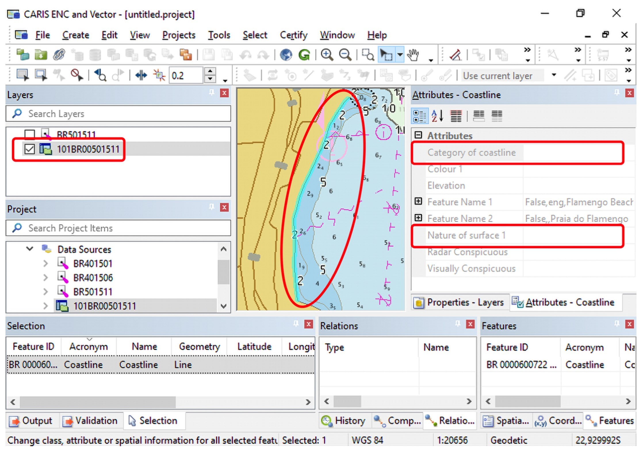
5.5.8 Unable to map S-57 enumeration code 3 (sandy shore) for attribute CATCOA for feature COALNE (BR000003232600001) to S-101 attribute categoryOfCoastline for feature Coastline.
This was one of the mistakes that happened more often in all conversions. It reports that the value “3-Sandy Shore” for the attribute CATCOA – Category of Coastline – cannot be mapped on the S-101. This fact is due to the remodeling of the object COALNE – Coastline – on the S-101. In the new standard, the attribute NATSUR – Nature of Surface – was included in this object, which enumerates the type of the material which the land surface or the sea bed is composed. Along with the value already mentioned in the error, the value “4-Stony Shore” was also numerous. Thus, we can observe in the Figure 6 below a simplified scheme of this change and how the new encoding for these objects will be carried out.
It is worth mentioning that the COALNE object still has the CATCOA attribute, but with less possible values. This change allows for greater detail of the data in S-101 ENC, which must be encoded individually to correct this error.
In the figures below, the attributes of the same coastline in Caris HPD 4.0 for both ENC S-57 and ENC S-101 are listed. In Figure 7, we can view the presentation of Caris HPD 4.0 for an ENC S-57, highlighting the ENC S-57 layer, the coastline, COALNE object and the CATCOA attribute with the value “Sandy shore”. In Figure 8, the same presentation is shown, however for an ENC S-101, with the ENC S-101 layer highlighted, the coastline, COALNE object and the CATCOA and NATSUR attributes. Note that these attributes were not correctly filled in on the S-101, so requiring manual updating by the encoder. It is also possible to observe that the other fields were filled in correctly.


5.5.9 Unable to map S-57 enumeration code 3 (deeper than the range of depth of the surrounding depth area) for attribute EXPSOU for feature UWTROC (BR000000826300001) to S-101 attribute expositionOfSounding for feature UnderwaterAwashRock
In the message above, it can be noted that the encoding of the value “3-Deeper than the range of depth of the surrounding depth area” for the attribute EXPSOU – Exposition of Sounding – cannot be mapped in the UWTROC object. According to a decision by S101PT, this value is no longer needed for this attribute. Therefore, this error does not require additional actions.
5.5.10 Unable to map S-57 enumeration code 4 (lattice beacon) for attribute BCNSHP for feature BCNLAT (BR000002252600001) to S-101 attribute beaconShape for feature BeaconLateral.
An error identical to the one mentioned above happened to the BCNSPP object. According to the message, the BCNSHP attribute – Beacon Shape – no longer has the value “4-Lattice Beacon”. This data was remodeled to the NATCON attribute – Nature of Construction – with the value “11- Latticed”.
According to the explanation given by the S101PT, a lattice is not a format, but the type of construction, explaining the change. The S101PT emphasizes that the BCNSHP attribute is mandatory and suggests that it be coded with the value “5-Pile Beacon” or even “3-Beacon Tower”, depending on each case. Also, according to S101PT, ENC producers must confirm it on a case-by-case basis. This case can be extended to all types of beacons.
5.5.11 Unable to map S-57 enumeration code 4 (telephone) for attribute CATCBL for feature CBLSUB (BR000003933200001) to S-101 attribute categoryOfCable for feature CableSubmarine.
The attribute CATCBL – Category of Cable – of the object CBLSUB – Cable Submarine – has been remodeled and no longer has the value “4-Telephone”. The S101PT explains that the “8- Fiber Optic Cable” value is more appropriate in terms of navigation. Therefore, the values of these errors must be changed manually to the new value “8-Fiber Optic Cable”, since the converter does not make this correlation automatically.
5.5.12 Unable to map TOPMAR as an attribute to Landmark. Unable to bind attribute topmark/colour e Unable to map TOPMAR as an attribute to Landmark. Unable to bind attribute topmark/topmarkDaymarkShape
This error comes from the transformation from objects to attributes. In S-57 ENC the topmarks were categorized as objects, however in the S-101 the topmarks have been remodeled to complex attributes, containing the attributes of “color” and “topmark / daymark shape”. However, as this error occurred in an object of the type “Landmark”, this correlation no longer exists in the S-101, because that object no longer has the attribute “TOPMAR”.
6. CONCLUSION
The need to update the ENC data structure is in evidence due to the technological improvements over the last 30 years. To meet this incredible speed of technological innovations, IHO has developed a new information standard called S-100, which encompasses several products, including the S-101 ENC. This innovation will change the way of encoding vector charts and creates the need to reassess all ENCs already produced.
This reassessment will demand great efforts from Hydrographic Services around the globe and, in order to assist and try to estimate the size of this demand, this work analyzed 18 ENCs. This sample included part of the coast of São Paulo state, Rio de Janeiro state and Espírito Santo state, thus covering an area of extreme importance for Brazilian maritime navigation. The chart samples used hereby encompassed the purposes of coastal use, approaching areas and port.
In order to achieve the objective of the work, a conversion software developed by ESRI was used, which transformed the ENC S-57 into S-101. After that, the results were analyzed and the causes and solutions for each type of error were defined. It was possible to verify and analyze the demand for work necessary to correct and update those ENC.
The conversion of the 18 ENCs generated more than 1,200 errors which were analyzed, grouped and separated by types. The two main errors observed were “warnings” and “information”, each one having different causes and solutions, as presented in the course of the article. There were 12 categories of “info” and 13 “warning”, with the majority, 1,127 of the 1,290 errors, being “warning”.
After analyzing the errors, causes and solutions, it has been concluded that the change in the data structure, presented in the S-101, significantly modified some objects and attributes. On the other hand, several others have not gone through major changes. Thus, in the light of DCEG and IHO (2019), these changes were identified and described throughout Chapter 5 of this study.
Emphasis was placed on the description and explanation of the attributes and what each one encodes, thus demonstrating the causes of errors and, in the sequence, a possible solution for each one was described.
The complexity, ease of coding and correcting errors varies widely from error to error. For example, some can simply be ignored, as the object has been remodeled and no longer has an attribute it used to have. On the other hand, some errors require additional study and deeper analysis on the source data structure, for its correction. Thus, the attempt to quantify and qualify errors regarding the need for work necessary for their correction is neither easy nor simple, so each type of error should be treated as unique and analyzed individually.
Also, based on the results presented by the converter provided by IHO, in partnership with ESRI, it seems that not all conversions are accurate and complete.
Another important point is the metadata of each ENC, mainly the minimum display scales (minimumDisplayScale), which must be studied and tested on board.
This article was not intended and could not exhaust the subject, given the complexity and variety of objects and attributes present in the information standards S-57 and S-101, in addition to having adopted a sample of Brazilian ENC. It is encouraged that further studies on the subject are carried out so that they can, in the same way, assist the Hydrographic Services around the globe in the hard task of updating ENCs to the new S-101 ENC standard.
Finally, after all the results have been presented, with analysis to identify causes of error and their solutions, it is expected that the present study will contribute to Hydrographic Services’ work. This also assists in the task of updating and making the two standards concomitant during the transition period to be defined by IHO.
7. BIBLIOGRAPHY
Korean Hydrographic and Oceanographic Agency, (2017). S-100 Sea trial of KHOA, s.l.: KHOA.
Miguens, A. P., (2019). Navegação: a Ciência e a Arte. 1 ed. Niterói: Diretoria de Hidrografia e Navegação.
International Hydrographic Organization, (2018). IHO electronic navigational chart product specification: IHO publication S-101. Viewed 20 May 2020, http://registry.iho.int/productspec/ view.do?idx=78&product_ID=S-101&statusS=5&domainS=ALL&category=product_ID&searchValue=.
International Hydrographic Organization, (2015). S-52 Specifications for chart content and display aspects of ECDIS. Viewed 06 October 2020, https://iho.int/uploads/user/pubs/standards/s-52/S-52%20Edition%206.1.1%20-%20June%202015.pdf.
International Hydrographic Organization, (2000). S-57 IHO transfer standard for hydrographic data. Viewed 20 May 2020, https://iho.int/uploads/user/pubs/standards/s-57/31Main.pdf.
International Hydrographic Organization, (2019). S-57 Removed & Remodelled Items. Viewed 20 April 2020, https://www.google.com/url?sa=t&rct=j&q=&esrc=s&source=web&cd=&ved=2ahUKEwjn5pfxjszwAhXWmZUCHSM4AQcQFjAAegQIAxAD&url=, https%3A%2F%2Fiho.int%2Fuploads%2Fuser%2FServices%2520and%2520Standards%2FS-100WG%2FMISC%2FS-57%2520Removed_Remodelled%2520Items.xlsx&usg= .
International Hydrographic Organization, n.d. S-101 Electronic Navigational Chart. Viewed 20 April 2020, http://s100.iho.int/product%20specification/division-search/s-101-electronic-navigational-chart-enc.
International Maritime Organization, (2014). Safety of Life at Sea. London: International Maritime Organization.
International Maritime Organization, (2020). e-Navigation. Viewed 21 April 2020, 8. AUTHORS BIOGRAPHY
Lieutenant Guilherme N. Vieira, Navigator of Hydrographic Vessel ” Sirius” . B.Sc. in Naval Science (Naval College, 2016), he completed the Hydrographic Course IHO/FIG/ICA Category A in 2020 (Directorated of Hydrography and Navigation – DHN). E-mail: guilherme.vieira@marinha.mil.br Flávia Mandarino, Brazilian Navy Commander (Ret), presently lecture Geodesy on Admiralty Radler de Aquino Instruction and Training Center (CIAARA – DHN). D.Sc. in Marine Geology and Geophysics (Fluminense Federal University – UFF, 2018) E-mail: flavia@marinha.mil.br