


1. Abstract
The deadliest tropical cyclone in 2019 was the Intense Tropical Cyclone Idai in the South-West Indian Ocean, which killed over 1,303 people in Mozambique, Malawi, Zimbabwe, and Madagascar. In this study, the impacts of cyclone Idai on the Mozambican Hydrographic Services is presented. The study has identified the need to settle an appropriate Disaster Risk and Management System in National Hydrographic Services, as well as, the need to strengthen the capacity of the National Hydrographic Services to respond to natural disasters and develop standard operating procedures where the support from international community may be of paramount importance.
2. Introduction
According to the English Wikipedia (2019), a tropical cyclone is a rapid rotating storm system characterized by a low-pressure center, a closed low-level atmospheric circulation, a spiral arrangement of thunderstorms that produce heavy rain , and strong winds, that in ocean may generate waves of high heights.
Tropical cyclones in 2019 were spread out across seven different areas called basins. During 2019, 143 systems were formed. 43 tropical cyclones have been named by either a Regional Specialized Meteorological Center (RSMC) or a Tropical Cyclone Warning Center (TCWC). The deadliest tropical cyclone of the year was the Intense Tropical Cyclone Idai in the South-West Indian Ocean, which killed over 1,303 people in Mozambique, Malawi, Zimbabwe, and Madagascar, and caused more than $2.001 billion in damages.
In Mozambique, the impact of tropical cyclone Idai was catastrophic in and around Beira City, where it caused the deaths of more than 600 people. An estimated 1600 people were injured and approximately 1.8 million people were affected. The World Bank’s rapid assessment made in April 2019, estimated USD 773 million in damages to buildings, infrastructure and agriculture, and a more elaborated evaluation on the donor conference for infrastructure reconstruction have estimated USD 3.2 billion as the cost for reconstruction post-cyclone Idai in Mozambique.
3. Event Characterization
Tropical Cyclone Idai started to develop on 4th March close to the coastline of the province of Zambézia as a tropical depression with wind speeds of about 55 km/h gusting up to 75 Km/h (WMO, 2019). The system made a first landfall on the same day, north of Quelimane. During the following 4 days, a remnant of low pressure persisted over land while the system headed north and then northwestward until the 6 March, before turning back east-southeastward early on 7 March close to the Mozambique-Malawi border. From 6 to 8 March persistent local and heavy rainfall with associated thunderstorms affected southern Malawi and the provinces of Zambézia, Sofala, Nampula, Tete and Niassa (rainfall amounts in excess of 400 mm were recorded at some INAM’s weather stations in Ulongue, Tsangamo, Mocuba). This caused a rise in water to above alert levels in the basins of Licungo, Raraga, Namacurra, Zambeze and in the sub-basin Revubuè. Resulting floods occurred in the lower Licungo and in the city of Tete
On 9 March, the remnant low pressure moved back towards the sea to the Mozambique Channel. At sea, it intensified rapidly maturing into an intense tropical cyclone with winds gusting up to 250 km/h by 11 March, off the western coast of Madagascar.
Idai (Figure 1) started to reverse its track early on the 11th towards the Mozambican coastline, as anticipated many days before by numerical weather prediction models. Since the 6th of March, this reversing track was well suggested by the European ensemble forecast with a possible threat of a mature tropical cyclone for central Mozambique. On 12 March, track forecast uncertainty had reduced and was well below usual standards, clearly indicating that Idai would hit the Beira area. Landfall eventually occurred on the evening of the 14th, around 2200UTC, in the northern vicinity of Beira as an intense tropical cyclone based on the South-West Indian Ocean Basin terminology that corresponds to category 4 (out of 5) on the scale used in Mozambique. At its landfall, Idai’s winds estimated by the Regional Specialized Meteorological Centre (RSMC) La Réunion were blowing at 165 km/h and gusting up to 230 km/h (real time analysis) bringing torrential rains and seas waves with very high heights likely exceeding 10 meters (WMO, 2019).
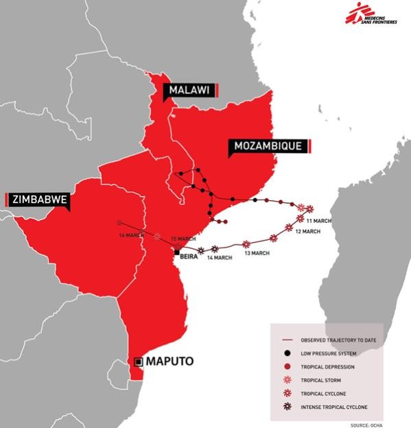
From 15th March, Tropical Cyclone Idai started to weaken as it moved inland. Associated heavy rainfall spread over Central Mozambique going inland up to eastern and central parts of Zimbabwe. This, combined with the river flows from upstream countries, fed the major and deadly flood event, mainly in the Búzi and Púnguè Rivers basins that started a few days (3 to 4 days) after the cyclone passed over Beira. The city of Beira and its peripheries, recorded moderate floods. In the same period the Save river basin recorded high water flows as a result of water coming from upstream, yet without significant impacts. The Dams of Cahora Bassa and Chicamba had an increase of volume of storage to nearly 99% and 76%, respectively.
4. Objectives of the paper and its alinment with National and International policies and strategies
The two main objectives of this paper are:
- Highlight the impacts of tropical cyclone Idai on the Mozambican Hydrographic Services;
- Emphasize and describe the identified needs to bring the National Hydrographic Services and Institutes back to the baseline of International Hydrographic Organization (IHO) standards after the occurrence of Tropical Cyclones.
Reaching the proposed objectives would create a basis for any future international (IHO, SAIHC, or at bilaterally) intervention, which should aim at enhancing the response capacity of the National Hydrographic Services in developing countries, in times following extreme weather or climate events.
Those objectives are seen as aligned with the visionary aspirations of SAIHC and IHO, very well enshrined in the IHO strategy, objectives and vision, especially on what concerns to:
- Assist MS to achieve sustainable development and improvement in their activities to meet hydrographic, cartographic and marine safety obligations, with particular reference to recommendations in SOLAS, and other international instruments – As per IHO capacity building strategy/policy paper (IHO, 2014).
- Create a global environment in which states provide adequate, standardized and timely hydrographic data products and services – As per IHO vision.
- Enhance cooperation on hydrographic activities among states on a regional basis – As per IHO Objectives;
- Support national initiatives aimed at obtaining better hydrographic information – As per IHO strategic directions (IHO, 2017)
5. Importance of Beira Port to the Country and the Region
Besides the importance of Beira Port to Mozambique, as it is the second most important port of the country, it also constitutes one of the infrastructures within the Beira corridor. Beira corridor (Figure 2), has been in existence for more than a century, since 1889 as a gateway to Zambia, Zimbabwe and Malawi’s export to the rest of the world (SundayMail, 2016). From a couple of years ago onwards, the corridor has also been serving the export/import of goods from/to DRC.
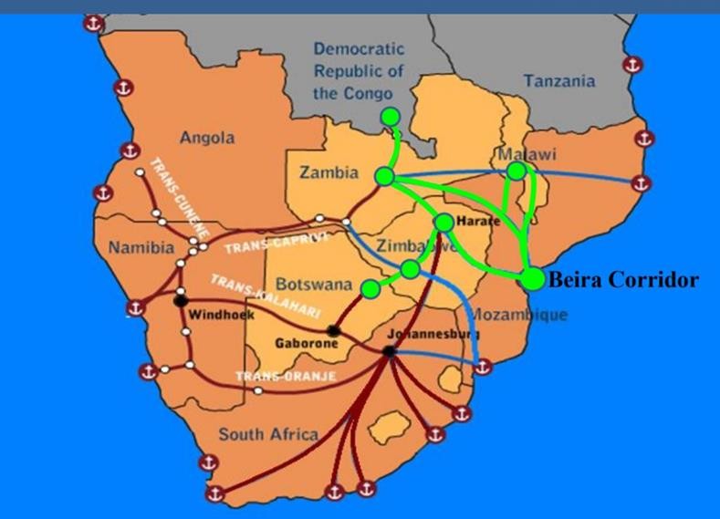
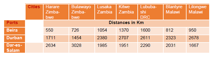
Using Beira Port presents also an opportunity to DRC, Malawi, Zambia and Zimbabwe to decongest the North-South Corridor, while ensuring the efficient and cost effective moving of goods, as per the information contained in table 1.
Therefore, apart from the immensurable benefits that the Beira Port brings to Mozambique, there is a need to fully explore the enormous opportunities that Beira Port can offer to those four Land locked countries as those countries (Zambia, Zimbabwe, DRC, and Malawi) seek for competitive- ness of their products and exports.
6. Effect of cyclone IDAI on the Hydrographic Services in Mozambique
An emergency meeting was held at INAHINA – Instituto Nacional de Hidrografia e Navegação – (National Institute for Hydrography and Navigation) on 15th of March, aiming to identify immediate measures to be taken to mitigate the possible effects of cyclone Idai, in Beira harbor. Among other measures, the meeting identified the creation of a commission to deal with the impacts of the cyclone to INAHINA as well as, to the Beira Port, and the mitigation measures, which would allow continuation of usage of Beira Harbor, as well as the continuation of provision of hydrographic services by INAHINA. Due to the lack of communication, and the impossibility to access Beira, the mission could travel to Beira only on 17th of March.
While in Beira, the mission identified a massive devastation/destruction, and a number of challenges impairing a conducive environment to ensure the delivering of Hydrographic Services for those demanding the Beira Harbor. The mission then proposed measures to address the identified destruction. A summary of the identified destructions, challenges, as well as, the proposed measures, are presented below:
=> Effects on the hydrographic assets
Location of the missed hydrographic boat (Lago Niassa)
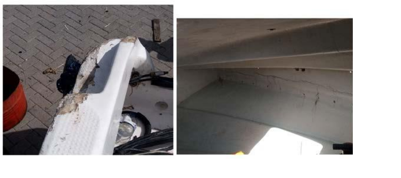
The Hydrographic boat Lago Niassa with all hydrographic equipment installed, drifted during the passage of the tropical cyclone Idai, and was found aground near the mouth of Buzi River, at a distance of approximately 10.0 Km from the quay/pier where it was docked. With assistance of a Vessel from the Fishery Office, the hydrographic boat was retrieved and brought back to the pier/ quay. The mission assessed the vessel conditions, and the main findings were:
- The access door to the cabin broken
- Several breaches on the boat
- Failures of the starboard engine
- Damage to some of the hydrographic survey hardware
Figure 3 illustrates the damages suffered on the hydrographic boat Lago Niassa, upon the passage of cyclone Idai.
Due to the significance of the damages identified, the lack of capacity to repair the boat locally, the need to have this unit in Beira to support the maintenance of the Buoys along the Beira access Channel, the boat was sent afterwards to one shipyard in Maputo, for restoration. The costs associated with restoration, as well as the mobilization costs of the boat to the Maputo Shipyard, was estimated at USD 40.000 (INAHINA, 2019).
The computer system of the Hydrographic Services, namely computers, printers, and servers, were also severely affected by the cyclone, as all them were submerged into water. The cost estimate to recovery the computer system corresponds to approximately to USD 18.000.
=> Effects on the aids to navigation
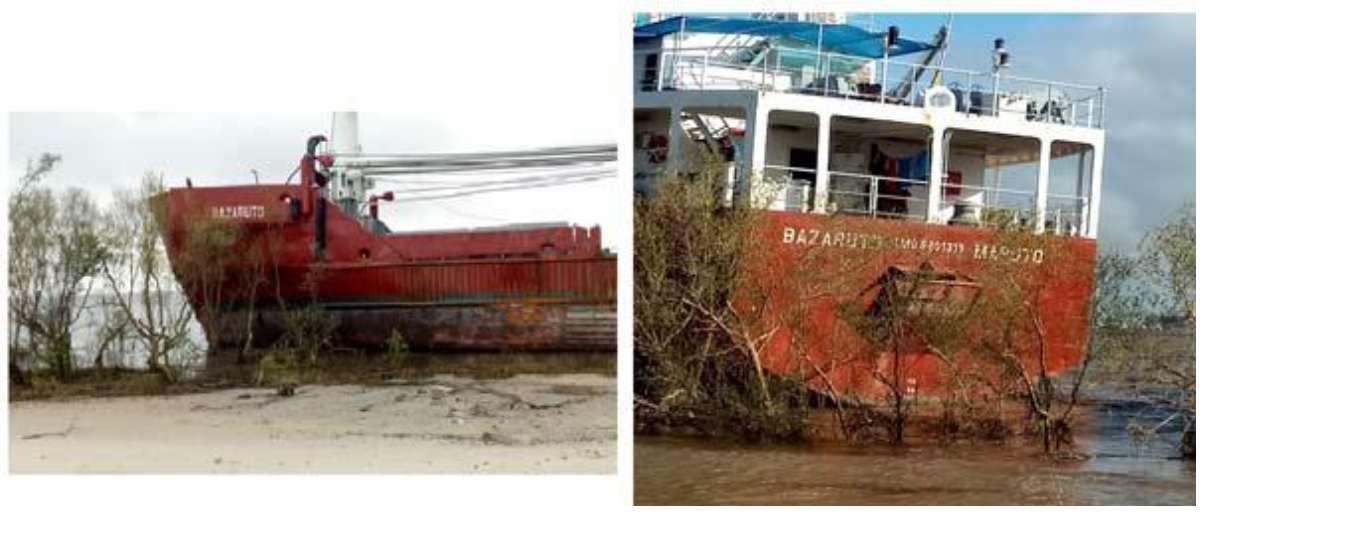
Location of the missed Buoy Tender (Beacon Ship) – Bazaruto
INAHINA maintains a Buoy Tender, Bazaruto, 52.3 meters length 11.2 meters beam, and 3.5 meters draft. Due to the very intense winds of approximately 230 Km/h, and higher wave heights likely exceeding 10 meters, the vessel crew withdrew from the vessel after starting the breaking of the vessel’s mooring lines. The vessel drifted during the night running aground into mangroves, at a distance of approximately 2.5 Km from the quay. The mission assessed the vessel conditions, and the main findings were:
- A breach in the collision-tank
- A tear on the bow
Figures 4 below illustrate the damages suffered on the Buoy Tender Bazaruto, upon the passage of cyclone Idai.
After small technical intervention made by INAHINA, in collaboration with the other National companies, the vessel was finally rescued from it grounded position and docked again in the Beira quay/pier. The rescue operation was made by contracting a South Africa company, at a cost of approximately USD 45,000, and currently the Vessel is still docked for restoration. These interventions may cost approximately USD 100,000.
Assessment of the buoys along the Beira Port access channel
With assistance from Port and Railway company in Beira, all the drifted buoys (three in all), were repositioned. Buoy Alpha was damaged and was removed as its tower needed to be repaired. Afterwards, there was a need to hire a tender vessel (as the existing tender vessel were affected with the cyclone) for the replacement of the Buoy. The estimated costs to carry out this activity is evaluated at USD 136,000
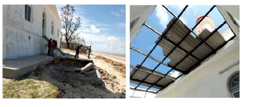
Assessment of the Beira Lighthouse (Macuti Lighthouse)
Findings in the lighthouse were as the followings:
- The protection wall was completely destroyed
- The sand material around the lighthouse had moved, exposing the underlying light- house structure to saltwater, and leaving the steps to access the lighthouse at risk of collapse.
Figures 5 below show the damages suffered on lighthouse, upon the passage of cyclone Idai.
The mission identified a consulting company to assess the damages and come up with a technical and financial proposal to restore the lighthouse. The restoration includes building of a structure for coastal protection. The restoration costs of the lighthouse, including the technical study, is estimated at USD 750 000
=> Effects on the INAHINA’s Office in Beira
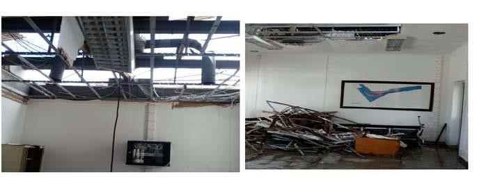
The cyclone Idai has caused:
- The removal of the roof of the INAHINA’s office in Beira
- Destruction of all the furniture
- All the computer equipment was damaged due to rain and saltwater intrusion into the office
- All the documents and archives were wet as result of water entering into the offices
Figures 6 below illustrate the status of the INAHINA’s office, upon the passage of cyclone Idai.
The estimated costs for recovering activities of the INAHINA’s office in Beira is estimated to be approximately USD 120000.
=> Identified challenges post cyclone
Upon the occurrence of the cyclone, INAHINA was called to carry out a hydrographic survey along the Beira access channel to verify if a container from the Beira Port, reported missing after passage of Cyclone Idai, was obstructing the access channel. Resorting to Side Scan Sonar, INAHINA has surveyed the channel, and identified no container along the channel. This activity was carried out at cost of USD 20.000
Another issue worthy of attention is the fact that, in 2018, INAHINA surveyed Beira Port Channel and its adjacent areas to update the Beira Port Approach and Beira Port Nautical charts. Upon the occurrence of the cyclone, which brought waves of almost 10 meters in height, it is suspected that the morphology of Beira Bay has undergone substantial modifications that would make it unsafe to produce an unlimited edition of Beira Charts based on the hydrographic data collected before the cyclone Idai.
In November 2019, INAHINA finally conducted a hydrographic survey with a single beam echo sounder, which was used to survey the adjacent areas of the channel, and a multibeam echo sounder, used to survey the Beira Port access channel. The total costs to this mission, corresponded to approximately USD 250.000,00.
7. Recommendations and Conclusion
Mozambique is the fifth most vulnerable country in the world to the natural disasters. According to MITADER (2016), the country is vulnerable to Sea Level Rise, Drought, Tropical Cyclones, and Floods. In 2019, Tropical Cyclone Idai severely affected the Sofala Province, where the Beira Port, the second major port of the country, is located. Beira Port not only benefits Mozambique but is also of paramount importance to land-locked countries, such as Malawi, Zambia, Zimbabwe, and Swaziland, as well as, to the others countries, like the Democratic Republic of Congo, as this port serves as a gateway for export/import of goods.
The Hydrographic Services of Mozambique were also harshly affected by the cyclone, particularly the infrastructure, hydrographic survey equipment, as well as on the Tender vessel, and Aid to Navigation system (Buoys). The total costs to recover the affected hydrographic services was estimated at more than USD 1,859,000, which corresponds to a substantial part of the INAHINA’s annual budget.
Almost all the infrastructure damaged, including the hydrographic survey vessel, were needed immediately following the cyclone. Hydrographic efforts were required for disaster recovery, not only to serve Mozambique country, but also the region as mentioned above.
The budget constraints faced by Mozambique, combined with the country’s vulnerability to natural disasters, is at odds with the country’s obligation to continuously provide Marine Safety Information to the users of Sea, and the role of the Beira Port to supply the country and the region. This cyclone exposed the Hydrographic Services in Mozambique to a set of challenges that leads us to recommend the following:
- The need to request support from IHO and other international institutions to define an appropriate Disaster Risk Monitoring and Management System in National Hydrographic Services, to mitigate the impacts of Natural disasters, in such events like Tropical Cyclone Idai.
- The need to strengthen the capacity of INAHINA to respond to natural disasters and develop standard operating procedures where the support from international community may be of paramount importance.
8. References
English Wikipedia (2019) – https://en.wikipedia.org/wiki/Tropical_cyclones_in_2019
IHO, 2014 – IHO Capacity Building Strategy
IHO, 2017 – IHO Strategic Plan – 2017
INAHINA (2019) – Information from the Finance Department.
MITADER (2016) – Avaliação das necessidades tecnológicas – priorização das tecnologias; zonas costeiras – moçambique
SundayMail (2016) – https://www.pressreader.com/zimbabwe/the-sunday-mail-zimbabwe/20160828/281706909107483
WMO Mission Report Following Tropical Cyclone IDAI