


Abstract
1. Motivation
The Baltic Sea is an international shallow, non-tidal area in the northern part of Europe with dense traffic. Accurate depth data and water level information is of absolute importance to preserve the safety of navigation in the area. So far, numerous local reference levels were used in the Baltic Sea for nautical charts and water level information, such as water level observations, forecasts and warnings. The exact definition of the chart datum may vary between countries, regions as well as over time. The matter of these existing Baltic Sea chart datums is a rather complex issue, not only for the navigators, but also for the responsible hydrographic offices and other users of depth data in general. Thus, a unified vertical reference system is important to improve navigation in the Baltic Sea region.
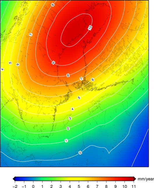
For centuries, the chart datums in the Baltic Sea were defined as the “mean sea level” (MSL), which was observed at tide gauges, i.e., a height obtained by a long-term average of the sea level readings measured with respect to the land at the particular tide gauge location. This implies that the chart datum is influenced by two different quantities – long term sea level changes as well as possible height changes of the land. Both quantities could not be observed separately. This has a great impact especially in the Baltic Sea region which is strongly affected by the postglacial Scandinavian land uplift phenomenon. While the climate-induced sea level rise has an order a few millimeter per year, the land uplift affects the heights by up to one centimeter per year. This results in a lowering of the depth in major areas of the Baltic Sea and is well observable by mareographs (see Figure 1).
The MSL-based chart datum is only well-known at the tide gauge location. With increasing distance it is hard to predict the actual height difference of the sea level with respect to the tide gauge location. The uncertainty of the sea level predictions may reach the order of several decimeters and limits the accuracy of the depth information in nautical charts. Updating nautical charts and references for different kind of water level information implied large work in the past, especially in Sweden and Finland (see Section 4).
Meanwhile, digital maps, satellite positioning and wireless internet have fundamentally changed the way we navigate in daily life. Regarding marine traffic, electronic nautical charts (ENC) replace paper charts. GNSS is used in hydrographic surveying not only to define the position in the horizontal direction but also in the vertical direction when measuring depths. To get the benefits of GNSS, the chart datum has to be well defined and compatible with GNSS positioning.
Modern hydrography is more than ship navigation and charted depths with respect to tide gauges. Spreading from environmental protection to economy, novel applications are typically multidisciplinary connecting the fields of hydrography and modern space-borne geodesy with for instance geophysics and telemetry. This is stimulated by increasing use of the sensitive coastal zones (e.g., offshore energy, safe vessel navigation, etc.). Another most relevant example is, of course, the monitoring of (global and regional) sea level changes by combining classical and modern geodetic space techniques (i.e., water level stations, geometric levelling, satellite altimetry and GNSS). Finally, GNSS based 3-D navigation becomes more common in commercial shipping and accuracy requirements of the depth information will increase. Future marine traffic will potentially see autonomous vessels which will require remote GNSS-based surveillance of the under keel clearance (UKC).
All these applications rely on observations on or of the sea surface by modern space-geodetic techniques. Thanks to GNSS and satellite radar altimetry, the height and the changes of both sea surface and land surface can nowadays be observed in a global Earth-fixed three-dimensional coordinate system with high spatial resolution. Heights obtained from these 3-D coordinates are related to a mathematical defined global mean earth ellipsoid, which can differ as much as 100m from mean sea level. Therefore, the ellipsoidal GNSS heights are not directly suitable for the most practical applications and have to be transformed to a meaningful physical height reference surface (HRS). This enables to realize a datum for nautical charts based on a geodetic height reference surface (see Section 3).
For practical applications on land, the use of GNSS-based height determination together with a compatible model of the HRS (called geoid in geodesy) have become standard and have replaced classic surveying techniques for height determination (mainly geometric levelling) in many geodetic applications. The European spatial and vertical reference systems
- European Terrestrial Reference System 1989 (ETRS89) and
- the European Vertical Reference System 2000 (EVRS2000)
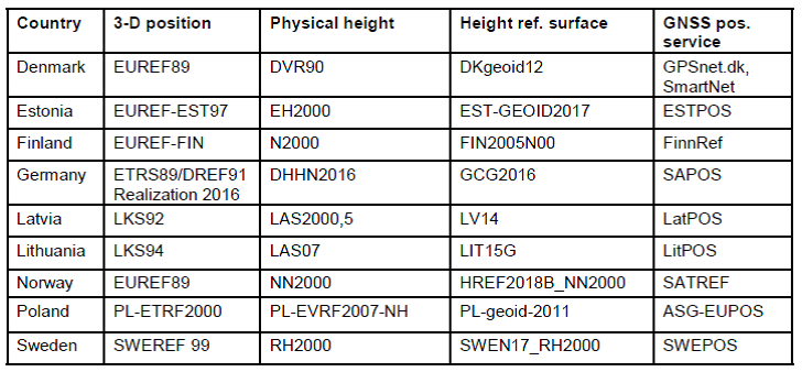
are well developed and widely distributed. They are part of the INSPIRE directive of the European Commission and are supported by the member states. The respective national geodetic infrastructures have either adopted these reference frames or are in very close agreement to it (see Table 1 and Figures. 2a-e). The same reference systems and technologies are already in use out at sea to reference modernized hydrographic surveys.
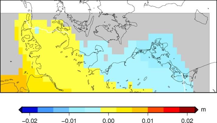
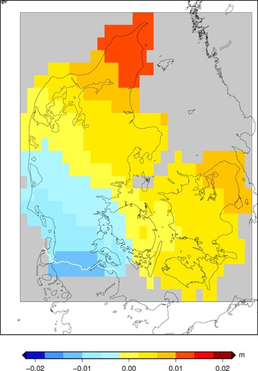
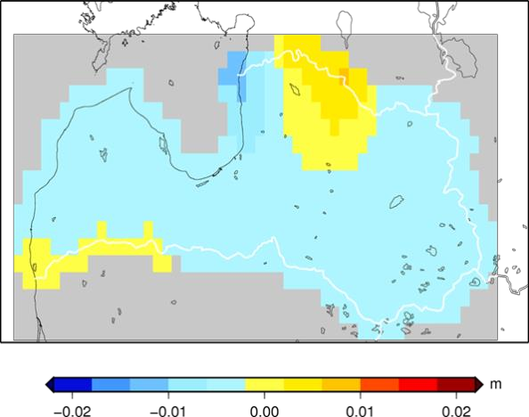
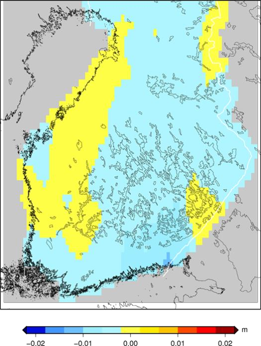
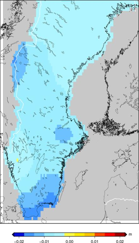
Figure 2 (a-e): Examples of differences between national heights and zero-tide EVRF2019 heights.
Keeping the aforementioned developments in mind, the common reference level Baltic Sea Chart Datum 2000 (BSCD2000) has been specified with the aim to
- replace the existing variety of reference levels by a seamless chart datum definition for the entire Baltic Sea;
- simplify the determination and use of bathymetric charts by using the existing European geodetic standards (European Terrestrial Reference System 1989 and European Vertical Reference System 2000) and to make the marine infrastructure of the Baltic Sea fully interoperable with the national geodetic infrastructure, namely the national satellite-based positioning services (e.g., SAPOS, SWEPOS, FinnRef) and the national height systems; thereby
- provide an optimal support for current and future marine GNSS aided applications and
- comply with future S-10X standards of the International Hydrographic Organization (IHO).
In particular, the main benefit for the mariner is a seamless transition from chart to chart, from country to country, and from sea to land, based on a unified height datum. This comes at the “price” of potentially changed reference levels in harbors and shifted charted depths (see Sections 3 and 4). Wherever possible, these changes will be introduced together with major updates of anyway outdated map sheets.
2. Organisational background for the establishment of the BSCD2000
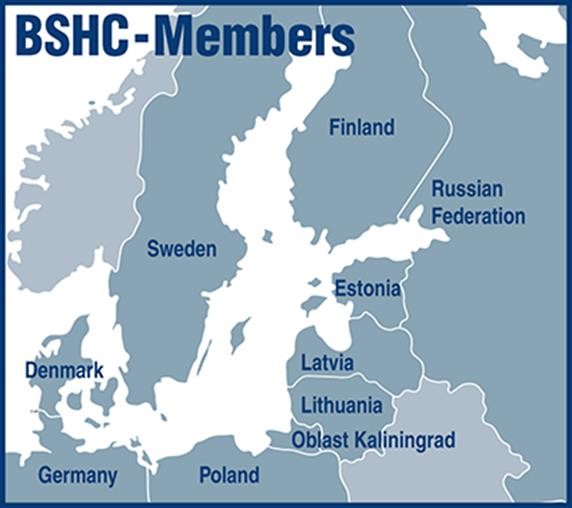
BSCD2000 was initiated by the Baltic Sea Hydrographic Commission (BSHC). The BSHC (http:// www.bshc.pro) is an integrant part of the International Hydrographic Organisation (IHO), promotes the technical cooperation in the domain of hydrographic surveying, marine cartography and nautical information among the neighboring countries of the Baltic Sea region. The main objectives of the Commission are the coordination of the production of the Baltic Sea INT Charts, the coordination of hydrographic re-surveys, harmonization of chart datums, harmonization of Baltic Sea ENCs, and the exchange of information and the harmonization of practices with regard to various issues related to hydrography. Its member states are visualized in Figure 3.
In 2005, the Baltic Sea Hydrographic Commission (BSHC) recognized the issue of the incompatible chart datums in the Baltic Sea and established the Chart Datum Working Group (CDWG) to develop a concept of a harmonized chart datum. The CDWG (http://www.bshc.pro/working-groups/cdwg) reports to the BSHC Conferences and aims to implement the Baltic Sea Chart Datum 2000 as a common reference level in the Baltic Sea. The working group cooperates with relevant bodies, reviews the progress of national plans and proposes harmonization actions. The working group also liaises with relevant IHO bodies and studies relevant IHO resolutions and specifications. It is currently chaired by Mr Thomas Hammarklint (SMA, Sweden) with Mr Jyrki Mononen (Traficom, Finland) as ordinary secretary.
After a feasibility study, it was decided and agreed that the harmonized vertical datum will be based on the European Vertical Reference System (EVRS). In September 2013, the 18th Baltic Sea Hydrographic Commission Conference decided to continue the work of the Chart Datum Working Group (CDWG) and wished the harmonized Baltic Sea vertical reference to be implemented. IHO BSHC has approved the name and the adoption of the Baltic Sea Chart Datum 2000 and the abbreviation BSCD2000.
BSCD2000 has been registered as Chart Datum number 44 in the IHO Geospatial Information (GI) Registry and can therefore be used as a reference datum in all future S-1001products. It applies to all national realizations of the European Vertical Reference System (EVRS).
The basic prerequisite for the realization and introduction of the BSCD2000 is the determination of a model of the height reference surface with sufficient accuracy. The practical works were significantly supported by the FAMOS project (www.famosproject.eu) whichwas co-financed by the European Commission. FAMOS stands for “Finalizing Surveys for the Baltic Motorways of the Sea” and is part of the “Motorways of the Seas”, a concept to develop European maritime traffic infrastructure within the framework of the Trans-European Transport Network (TEN-T) policy. Major activities within FAMOS consisted of the coordination and execution of shipborne campaigns to measure the gravity data needed to compute an improved geoid model as the HRS for the BSCD2000, as well as the computations of the geoid2 model itself.
3. Definition and realization of BSCD2000
In the following, only a general overview shall be given from the user’s perspective. For the full geodetic detail, the reader is referred to the BSCD2000 paper (Ågren et al., 2019).
The first of the two most important characteristics of BSCD2000 is that it is not anymore defined with respect to the (changing) local mean sea level (MSL).
Instead, a well-defined uniform and accessible height reference surface (HRS) is used that is equal to the distinct equipotential surface of the Earth’s gravity field called the geoid.
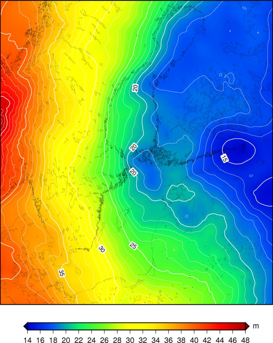
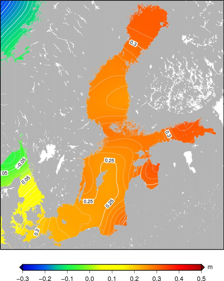
The instantaneous sea surface is deflected from the above equilibrium surface due to ocean dynamics (induced by currents, temperature, salinity variations, wind etc.) in combination with the coastal shape and bathymetry. The long-term average of these deflections is not zero, hence the mean sea surface is offset from the geoid. The static part of this difference, which can reach up to approximately ±2 m worldwide, is called mean dynamic topography (MDT). It can be observed and computed either from oceanographic models or from combined space-geodetic observations (altimetry and gravity satellite missions). In the Baltic Sea, the MDT is generally positive (compared to the MSL/MDT of the North Sea) with a slope of approx. 30 cm towards the North-east, corresponding mainly to decreasing salinity. Figures 4 and 5 show examples for a geoid model and a space-geodetic MDT model of the Baltic Sea, respectively.
This change of chart datum to a zero level that is a little offset from MSL may at first glance appear unnatural to the mariner. However, the advantage of the geoid-based definition of the chart datum is that the geoid is virtually independent from changes of sea level and can be determined to high accuracy without sea level observation (see next paragraph). Thus, as motivated in Section 2, the geoid provides the required unified reference surface in order to monitor absolute and relative sea level changes by combination of space-geodetic techniques (GNSS, satellite altimetry) and classic local sea level observations along the coast (water level stations, geometric levelling). This holds true also for the Baltic Sea where global sea level rise (i.e., dynamic ocean) is contrasted by postglacial land uplift (i.e., dynamic Earth), since the latter effect can be modelled with high accuracy.
Geoid-based HRS are realized by so-called geoid models, i.e., gridded values of the geoid height with respect to the reference ellipsoid used for GNSS applications. They can be computed from gravimetric measurements with a typical internal standard uncertainty of 1-2 cm in areas with good gravity data coverage. For practical use, the gravimetric geoid models are fitted to the ellipsoidal and physical heights of co-located GNSS and levelling benchmarks in order to become compatible with the national height system realizations. The HRS for the BSCD2000 will be an adopted quasigeoid3 model referenced to a common zero level.
In this respect, BSCD2000 replaces the so-far heterogeneous and inconsistent historical MSL realizations between countries, or even between map sheets or harbors within the same country.
The computation of this geoid model was stimulated by preparation works co-financed by the EU. Acquisition and measurement of the necessary data and the computation of interim (i.e. preliminary) geoid models were organized and performed within the project “Finalizing Surveys for the Baltic Motorways of the Sea” (FAMOS). Unfortunately, the last phase of the FAMOS project (2019-2020) could not be realized, so that the finalization of the BSCD2000 HRS is now coordinated by the CDWG and planned for the end of 2022.
The second most important characteristic is the new and unified zero level. BSCD2000 will be linked to the Normaal Amsterdams Peil (NAP).
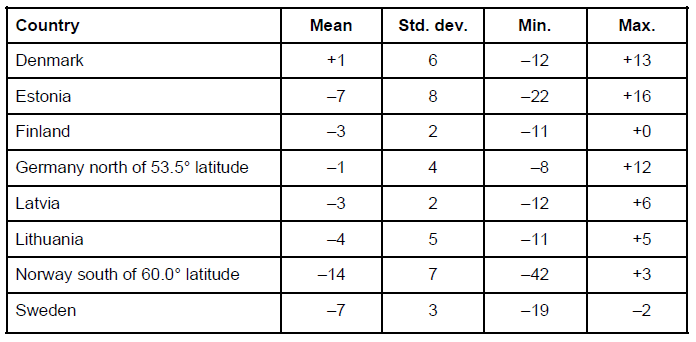
NAP is the zero level for the European Vertical Reference System (EVRS) but also for most countries around the Baltic Sea. All states formerly referring to the Kronstadt datum have changed their national height systems or are in transition to change to the EVRS, except for Russia4. Numerically, these national realizations of the NAP coincide at the centimeter level, as demonstrated in Figs. 2a-e and Table 1 in comparison with EVRF2019, the last official release of the European height system EVRS (Sacher et al. 2019). Consequently, the respective national height systems can be considered as ready-to-use realizations of the BSCD2000 within its specification (overall standard uncertainty better than 5 cm, sufficient for the typical precision of charted depths; see further Ågren et al. 2019).
Likewise, the HRS of the BSCD2000 will be aligned to the respective national HRS on land with smooth transitions from country to country. The ellipsoidal height part of the quasigeoid model is referenced to the GRS 805ellipsoid (Moritz 1980) of the national realizations of the European spatial reference system ETRS89 used for GNSS, whereas the physical height part is again consistent with the national levelling heights6.
By that, BSCD2000 is inherently connected with the existing geodetic standards for height determination (European reference systems ETRS89 and EVRS), making it compatible with the national geodetic infrastructure, such as GNSS positioning services. In particular, the connection to the height systems on land facilitates the planning and construction of offshore projects mainly in the energy sector.
In other words, BSCD2000 shares the “common European zero levels for levelling and GNSS”.
Hence, BSCD2000 for the first time enables seamless cross-border use of real-time GNSS positioning in combination with ENC for ship navigation in the Baltic Sea. This also forms the foundation of novel techniques that are emerging under the term “Sea Traffic Management”. Based on real-time GNSS, high-resolution ENC and unified water level forecasting, the ship can continuously monitor its current and projected UKC without echo sounding. One highlight application of this “situation-aware navigation” that also has been studied within the EU co-funded FAMOS project are ship routes optimized for fuel efficiency, because the fuel consumption of a large vessel increases considerably for low UKC due to the hydrodynamic squat effect.
4. Practical implications
New nautical products that use BSCD2000 are identified by the chart datum name BSCD2000<X>, where <X> denotes the respective national height system realization according to Table 2 (e.g., BSCD2000RH2000 for Sweden).
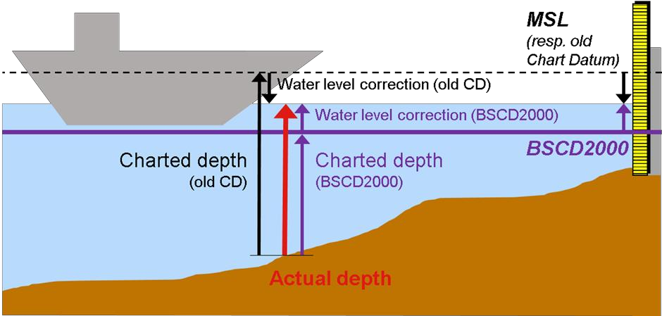
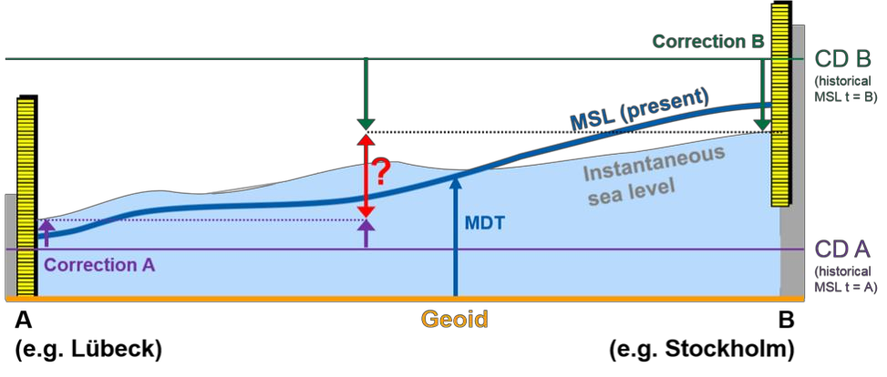
The main consequence for the mariner is that the charted depth in BSCD2000 changes by a constant value compared to the old zero level. The offset is individual per country or per map sheet, depending on the former MSL-related chart datum. In most cases, this offset will be negative, since the new zero level of the BSCD2000 is in general below the present day MSL for the Baltic Sea (see Figure 6 for a generalized visualization and Figure 7 for a map of the national MSL realizations currently in use). However, for charts of areas strongly affected by postglacial uplift and referring to very old MSL realizations, the change to BSCD2000 may be considerable. Figure 1 gives an impression of the land uplift rates according to the model NKG2016LU (Vestøl et al. 2016).
At the same time, real-time water level information (water level observations, corrections to the charted depths, forecasts, etc.) will also be changed accordingly to comply with the new chart datum. This also allows for a better and easier monitoring and prediction of the current and future sea states out at sea, since real-time oceanographic models can be simply interpolated (Figure 8), whereas switching between the sometimes far-distant mareographs and their local references may introduce a large error margin (Figure 9).
The transition from the numerous MSL-based chart datums of each country to BSCD2000 is a complex and stretched process from the first decisions to the final implementation in the chart products. In particular, paper charts need longest to be switched due to the long production cycles. Some countries, like Estonia, have already informed mariners about the changes to BSCD2000 and have published the first products. Others, like Denmark, are about to formally adopt BSCD2000 as the name of their chart datum without having to actually change their charted depths. Therefore, this section only gives an overview about the general situation in the respective countries. Table 2 summarizes the national geodetic reference frames, positioning services and HRS realizations that can be used with BSCD2000. Regularly updated details about the implementation status as well as instructions for users, e.g. leaflets, are provided via the CDWG website (http://www.bshc.pro/working-groups/cdwg).
In Sweden and Finland, a calculated MSL has been used as reference level (chart datum) for nautical charts and water level information. The reference level for regularly updated epochs (estimated present-day MSL) was estimated from long time series of annual mean values of mareograph observations. Depths from printed charts needed to be converted semi-automatically by means of a correction formula in order to correct for the time difference and to make the charted depth compatible with the provided water level information. As motivated in Section 2, this two-step approach implied a lot of work to keep the nautical products updated and consistent. At the same time, it was not straightforward and error-prone for the mariner.
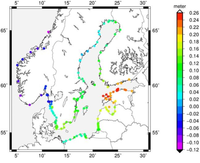
Thus, decisions to make a transition to BSCD2000 in Sweden and Finland have come a long way. In Sweden, both water level information and 50% of all nautical charts are now using BSCD2000. In Finland, part of the bathymetric and chart data have already been transformed to BSCD2000. Water level information is ready to be provided in BSCD2000 when first charts will be published in the new datum. Figure 7 details the estimated height of the current calculated MSL relative to BSCD2000 for selected mareographs in Sweden and Finland.
In the Baltic Sea regions of Denmark, a reference level close to the national height system DVR90 is already being used as chart datum, which can now be considered as a national realization of the BSCD2000. This means that for a user in Denmark nothing changes and the official national geoid model can still be used at sea.
Likewise, chart datum and MSL observations in Germany have traditionally been linked to the national height system. In 2016, the previous realization DHHN92 was replaced by DHHN2016. Both old and new realization are consistent with the EVRS, and the differences between the two are small and well within the specifications of the BSCD2000. Germany is now in the process to formally adopt BSCD2000DHHN2016 as the chart datum name in its Baltic Sea products, yet without actual changes for the user.
In Norwegian waters, on southern Skagerrak, a reference 20 cm below Lowest Astronomical Tide (LAT) is used as chart datum.
On the eastern side of the Baltic, in Estonia, Latvia, Lithuania and Poland, the transition from Kronstadt-based datums into the new system has come a long way, even if the old and new reference systems will be working in parallel for many more years to come. The transition into the new system for the paper charts will take longest time to change.
5. Summary and Outlook
So far, several countries around the Baltic Sea are using BSCD2000 as the common reference level for nautical charts as well as for water level information. According to the time schedule and the roadmap (http://www.bshc.pro/media/documents/CDWG/CDWG+RoadMap.pdf), the plan is to implement the common reference level until 2023. Almost all countries have taken the necessary decisions to move further in the implementation process, however this ambitious goal will most probably not be reached by all countries. For paper charts, the implementation will take longer time and there will be a significant transition period that will last for several years after 2023. Hydrographic offices will publish information concerning the national plans and progress of implementation since there will be differences in schedules of publication of charts and water level information between countries.
There are many benefits to be achieved with the implementation of BSCD2000. All depth and water level information will be provided in the same datum within the whole Baltic Sea. This eliminates the confusion between different chart datums and makes data transfer between national Hydrographic Offices and other organizations safer and easier, thereby contributing to safety of navigation in the highly frequented Baltic Sea. Further, on it enhances wider and easier use of depth data and promotes utilization of future navigation systems based on International Hydrographic Organization (IHO) S-10X standards.
BSCD2000 is based on the common European Vertical Reference System to which many national height systems are linked. Thus, depths on sea and heights on land will be referenced to the same reference system, facilitating e.g. offshore engineering in the sensitive coastal zones of the Baltic Sea. BSCD2000 can be used with GNSS applications by means of a consistent height reference surface, which will be realized by a high-resolution geoid model. The computation of this model was promoted by the EU co-financed project FAMOS and is now being finalized. It is planned to adopt the “FAMOS geoid” as the recommended physical height reference surface (HRS) for the BSCD2000 and make it available at no charge latest 2023. Compared to the national HRS, that are also compatible with BSCD2000 and can still be used (see Table 2), this model will provide the advantage of a seamless transition across the national borders.
Finally, BSCD2000 facilitates future applications that require an integrated spatial reference at sea and, thus, responds to the growing interrelationships between disciplines like hydrography, oceanography, geodesy, geophysics, climate research, coastal protection, and traffic management.

6. References
Ågren, J., Liebsch, G. and Mononen, J. (2019). „Specification of the Baltic Sea Chart Datum 2000 (BSCD2000)”, http://www.bshc.pro/media/documents/CDWG/CDWG+Specification+of+the+Baltic+Sea+Chart+Datum+2000.pdf (last access April 2, 2020)
Andersen, O.B., Knudsen P. (2009). „The DNSC08 mean sea surface and mean dynamic topography“, Journal of Geophysical Research, 114, C11, http://doi.org/10.1029/2008JC005179.
BOOS (2020). “BOOS sea level stations“. http://www.boos.org/wp-content/uploads/mwreg_boos.pdf (last access May 15, 2020) CRS-EU: http://www.crs-geo.eu (last access April 2, 2020)
ETRS89a: http://etrs89.ensg.ign.fr (last access April 2, 2020)
ETRS89b: Boucher, C. and Altamimi, Z., The EUREF Terrestrial Reference System and its first realizations, EUREF Meeting, Bern, Switzerland March 4-6, 1992
ETRS89c: European Commission, Joint Research Centre, Space Applications Institute Proceedings & Recommendations of Spatial Reference Workshop, November 1999, http://www.crs-geo.eu/pub03ProceedingsWS1999.pdf (last access April 2, 2020)
EVRS: https://evrs.bkg.bund.de/Subsites/EVRS/EN/Home/home.html (last access April 2, 2020)
Moritz, H. (1980). “Geodetic reference system 1980”. Bulletin Géodésique (1980) 54(3):395-405;
Bulletin Géodésique (1984) 58(3):388-398; Bulletin Géodésique (1988) 62(3):348-358; Journal of Geodesy (2000), 74, pp. 128-133. https://doi.org/10.1007/BF02521480
Häkli, P., Lidberg, M., Jivall, L., Nørbech, T., Tangen, O., Weber, M., Pihlak, P., Liepins, I. and Paršeliunas, E. (2016). „The NKG2008 GPS campaign – final transformation results and a new common Nordic reference frame”, Journal of Geodetic Science, 6, pp. 1-33. https://doi.org/10.1515/jogs-2016-0001
Sacher, M. (2019): “The European Vertical Reference System (EVRS) – development and latest results”, Geophysical Research Abstracts, 21, EGU2019-1811.
Vestøl, O., Ågren, J., Steffen, H., Kierulf, H. and Tarasov, L. (2019). “NKG2016LU – A new land uplift model for Fennoscandia and the Baltic Region”, Journal of Geodesy, 93, pp. 1759-1779. https://dx.doi.org/10.1007/s00190-019-01280-8
7. Authors Biography
Joachim Schwabe is a scientific staff member of the unit “Integrated Spatial Referencing” at the German Federal Agency for Cartography and Geodesy (BKG). He graduated as a geodesist from the Technische Universität Dresden (TUD) in 2008 and finalized his PhD thesis on regional geoid modeling in the polar regions in 2015. An opportunity to assist the computations for the quasigeoid model GCG2016 led him to the BKG, where he is now contact person for the GCG models and GNSS-based height determination. E-mail: joachim.schwabe@bkg.bund.de
Jonas Ågren is associate professor in geodesy and senior lecturer at the University of Gävle in Sweden. He is also part time senior geodesist at Lantmäteriet, the Swedish mapping, cadastral and land registration authority. He received his PhD degree in physical geodesy at the Royal Institute of Technology in Stockholm (KTH) in 2004. Since then he has worked with geoid modelling, height systems and gravimetry in Sweden and the Nordic/Baltic countries. He was the chairman of the working group on geoid and height systems of the Nordic Geodetic Commission (NKG) between 2010 and 2018, and leader of FAMOS activity 2 (Harmonising vertical datum/Improving vessel navigation for the future) between 2015 and 2018.E-mail: jonas.agren@hig.se
Gunter Liebsch is head of the unit “Integrated Spatial Referencing” at the German Federal Agency for Cartography and Geodesy (BKG), dealing with the German and the European height systems, GREF (GNSS reference station network in Germany) and the national quasigeoid model GCG. He graduated as a geodesist from the Technische Universität Dresden (TUD) in 1990 and finalized his PhD thesis on the processing and use of water level time series for geodetic and geo-dynamic applications in the Baltic Sea in 1997.E-mail: gunter.liebsch@bkg.bund.de
Patrick Westfeld is head of German Hydrographic Office‘s R&D section “Geodetic- hydrographic Techniques and Systems” at the Federal Maritime and Hydrographic Agency (BSH). His activities range from conceptual issues pertaining to hydroacoustic and imaging sensor technologies, sensor integration and modeling, algorithmic development and software implementation up to and including application-specific implementation and practical transfer in the production environment. After graduating as a geodesist from the Technische Universität Dresden (TUD) in 2005, he conducted research in the fields of photogrammetry and laserscanning and finalized his PhD degree in 2012 on geometric-stochastic modeling and motion analysis. E-mail: patrick.westfeld@bsh.de
Thomas Hammarklint is the Chairman of the BSHC Chart Datum Working Group and works at the Swedish Maritime Administration (SMA). He graduated as a physical oceanographer from the Gothenburg University in 2002. He is the Swedish representative and expert in several working groups and programs related to water levels, data exchange and reference levels, such as IOC Global Sea Level Observing System (GLOSS), IHO Tidal Water Level and Current Working Group (TWCWG), NSHC Tidal Working Group (TWG) and Baltic Sea Operational Oceanographic System (BOOS). E-mail: thomas.hammarklint@sjofartsverket.se
Jyrki Mononen is an expert at the Finnish Transport and Communications Agency Traficom in the Hydrographic Survey Services. He is the ordinary secretary of the BSHC Chart Datum Working Group. He graduated as MSc in land surveying an the Helsinki University of Technology in 1995. He has been involved in chart datum definitions in Finnish nautical charts and navigational information, national specifications for hydrographic surveying and procurement of hydrographic surveys. He is Finnish representative in IHO Tides, Water Level and Currents Working Group and Data Quality Working Group. E-e-mail: jyrki.mononen@traficom.fi
Ole B. Andersen is professor in marine geodesy and head of the hydrosphere group at DTU Space at the Technical University of Denmark which is the national space institute of Denmark. His activity in the working group has been to provide satellite-based long-term estimates of mean sea level and mean dynamic topography as a supplement to and for the evaluation of the FAMOS geoids. Ole is Ph.d. from the University of Copenhagen in 1996 and has since worked on marine geodesy focusing on development of global reference surfaces for gravity and mean sea surface as well as ocean tide models. E-mail: oa@space.dtu.dk
- The S-100 Standard (https://iho.int/en/s-100-universal-hydrographic-data-model, last access May 15, 2020) is a framework document that is intended for the development of digital products and services for hydrographic, maritime and GIS communities. It comprises multiple parts that are based on the geospatial standards developed by the International Organization for Standardization (IHO).
- The geoid describes the undisturbed sea level in equilibrium as if there were no external forces (wind, currents, temperature, salinity). In geodesy, it is the classic height reference surface for the realization of “heights above sea level” on land.
- The conceptional difference between geoid and quasigeoid is a geodetic subtlety that is only relevant on land at high altitudes.
- Only for Russia, simple transformation models between national heights and BCSD2000 will be necessary, probably by means of local datum shifts for the areas of Oblast Kaliningrad and the Gulf of Finland/St. Petersburg.
- The geometric shapes of the GRS 80 and the WGS84 ellipsoids are identical at the sub-mm level.
- The Scandinavian countries are particularly affected by postglacial land uplift. BSCD2000 assumes the land uplift epoch 2000.0. This means that all relevant coordinates and quantities (ellipsoidal heights, physical heights, quasigeoid heights) refer to this common epoch, as opposed to the previously inconsistent MSL epochs. Compared to that major geophysical effect, the impact of expert-level details – such as treatment of the permanent tide – are within the uncertainty specifications of BSCD2000 and the national EVRS realizations, so that they are not discussed in this paper. For such geodetic details, the reader is again referred to the BSCD2000 specification paper (Ågren et al. 2019).