
Abstract
The Oceans, coastal waters, including rivers and lakes, navigable or not, cover about 70% of our Planet… The definition of Hydrography varies from: “…the science of surveying and charting bodies of waters, such as oceans, seas, lakes and rivers”; and a variation of definitions, to the definition from the International Organization (IHO) in February 2020. In the last decades we have been progressing from “GRAPHIC”… to “DIGITAL”…and SPATIAL.
This Article suggests that a new word be adopted to distinguish the past analog hydrographic production chain from the present digital hydrographic data centricity, and especially for the future expansion of the role of hydrography in the world.
*NB This Article reflects only the opinion of the Author and H2i.
Introduction
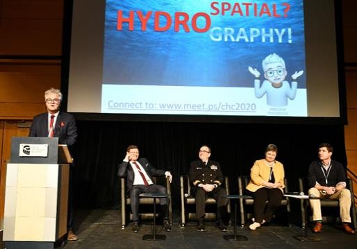
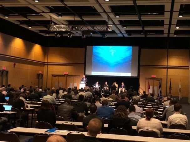
Close to 400 participants gathered for the Canadian Hydrographic Conference (CHC) 2020, from February 25 to 27, in Québec City, Canada http://www.chc2020.org. The event was organized by the Canadian Hydrographic Association (CHA) with the support of the Canadian Hydrographic Service (CHS) and the sponsorship of many commercial providers of products and services related. During the opening plenary session, the author had the honour to make a dedicated presentation on “What is Hydrospatial?” before inviting a panel of senior figures and the audience to discuss the topic further. The following is a summary of a very engaging session.
1. The issue
The session was introduced as a “hydrospatial activism”, with the deliberate intention of provoking and initiating a discussion about acknowledging the revolution in which hydrography finds itself, and the requirement to apply a new, modern and inspirational name for our different era.
What we do and its impact is obviously more important than a word can convey. Many might not consider it so important to adopt the word “hydrospatial”. We could just continue to use the word hydrography, and define and explain what is happening and the changes taking place simply as an evolution. It could be embracing and the adoption of new technologies. And also the related expansion of the scope, the role and mandate of hydrography, as we know it.
However, words are the way we express ourselves, and in particular, the way that we transmit our ideas and concepts to others. We are going through a “marine geospatial” revolution in which the concept of what we do, who we serve and the benefits of our data are changing – and this is so dramatic that it requires us to adopt a new word to describe it. We need a word that conveys the image of the modern, hi-tech, multi-role, digital data environment in which we now operate. The suggestion is that this word should be “hydrospatial!”
2. The Rationale

Noting that the nautical chart and the bathymetric map – at various scales, from the smallest to the largest, have until recently been the primary standardized windows to access and use our sources of data. However, the role of our data and the way we collect it is expanding, and its scope now goes well beyond data that provides a relatively simple map of the seabed – such as in an S-57 electronic chart. It now includes all other related data, such as: marine protected areas; biological sensitive areas; traditional and environmental knowledge; real-time and forecasting for 3 dimensional currents, water levels, overhead clearances; and more (marine geospatial) data. It is much more than nautical charts and navigation. It is the pivotal element of marine spatial data infrastructures (MSDI), marine spatial planning (MSP) and the marine cadastre. It is now used and fused with data from land, coastlines, inland waters and offshore. This is the reason “why” and “when” we now need to describe it as “hydrospatial” data!
Both defence and commercial shipping users of traditional hydrographic products, data and information now seek additional information and capabilities from our data. An ever-increasing community of additional users that seek a green future through a sustainable blue economy (1) is joining them. They, too, are in need of more data and much more than traditional hydrographic products and services. They are looking for “marine geospatial” data and information. They are users “who” need “hydrospatial” data!
The managers of coastal zones must consider sea-level rise, coastal erosion and crustal subsidence. Nearshore, offshore and remote areas (polar regions in particular) are becoming more accessible and attractive both for natural resources and for adventurers. All this drives the need for “where” “hydrospatial” data are needed – not just nautical chart data!
We have to adopt faster all remote sensing technologies and various autonomous craft for hydrographic data acquisition (satellite, airborne, surface, underwater, etc.) as well as maintaining minimal traditional ship-based units with ever-more sophisticated sensors. These are “how” high-tech capabilities evolve and deserve to be adopted by a name like “hydrospatial” that inspires inclusion beyond traditional.
3. The Suggested Draft Definition
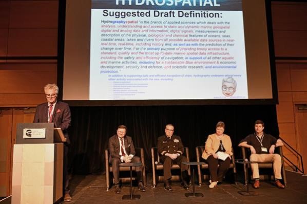
At the Conference, it was suggested that the definition of “what” hydrospatial could be based on the existing February 2020 IHO definition of hydrography. The proposed following changes were presented:
2020/02/25 – Hydrographyspatial “ is the branch of applied sciences which deals with the analysis, understanding and access to static and dynamic marine geospatial digital and analog data and information, digital signals, measurement and description of the physical, biological and chemical features of oceans, seas, coastal areas, lakes, estuaries and rivers from all possible available data sources in near-real time, real-time, including history and, as well as with the prediction of their change over time. For the primary purpose of providing timely access to a standard, quality and the most up-to-date marine spatial data infrastructure, including the safety and efficiency of navigation; in support of all other aquatic and marine activities, including for a sustainable Blue environment, economic development, security & defence, scientific research, and environmental protection.”
In addition to supporting safe and efficient navigation of ships, hydrography underpins almost every other activity associated with the sea, including:
Resource exploration
Environmental protection and management
National marine spatial data infrastructures
Recreational boating
Maritime defence and security
Tsunami flood and inundation modeling
Coastal zone management
Toutism
Marine science
In proposing this draft definition, the focus of the role is more on analysis, understanding and judging the quality of data from multiple sources rather than simply acquiring data. The intent being to move away from a primary focus on navigation, although it is clearly included and still considered core and of key importance.
The terms “biological and chemical” were added in the definition, not so that future “hydrospatial” experts will own and manage such types of data, but they will be prepared to integrate and fuse that data into an accessible, authoritative and accurate (best quality available) up to date “marine geospatial” infrastructure. This suggested draft definition is a mouthful and is not pretending to be the final definition, it was offered as a starting point to initiate an important conversation.
The Different Perspectives and the Discussion.
Based on the opening presentation, the four panelists aired their views, including the following quotes:
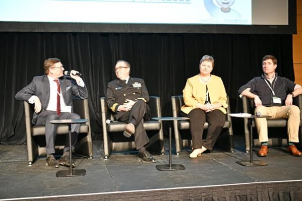
The IHO Secretary-General commented: … “to adopt a new word and official definition in the IHO Hydrographic Dictionary S-32 would require a formal proposal put forward to the affected experts of IHO´s Hydrographic Dictionary Working Group. Hydrography is clearly going through major important changes that will require an expanded role serving an increasing group interested in the Blue Economy proponent… If this requires a new word to express the expanded scope and to address the third and fourth dimension of our undertakings, “hydrospatial” will find its way into our spoken and written language.”
The Hydrographer General of Canada remarked: …”showing how a new word can fill a gap by using it in sentences is more important than having it officially adopted. Just use it!”
The Director, US Office of Coastal Surveys provided the comment: …“The field of hydrography is changing rapidly—we have access to both a wider variety and a massive volume of relevant data than ever, and the demand for our data and expertise is growing beyond charting. This conversation about the language of identity is just the beginning. We need to also take a hard look at our education and qualifications in light of these changes.”
The Chair of COMREN, representing Academia, said: … “ accredited academic programs have already added material, courses and learning objectives that go beyond international requirements to adapt and keep up with the rapid technological changes in hydrography that could be qualified as hydrospatial… ”
4. Engaging the Participants
During this session we used a live voting application to engage the audience, and although not all connected to the on-line voting, a very good sample of about the third replied. In average, more than 100 voters per question replied in real time to the 6 questions, their answers below with the following results:
5. The Compiled Results
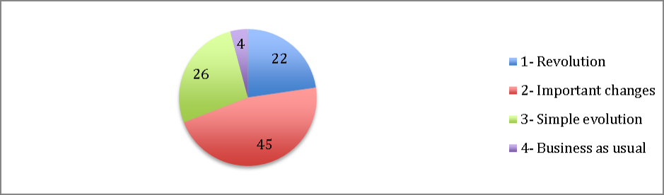
a. What is Hydrography going through? (97 votes)
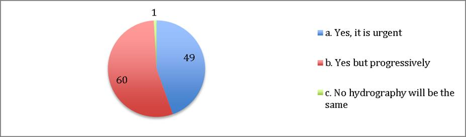
b. Should Training/Certification be adapted to rapid Technological changes? (110 votes)
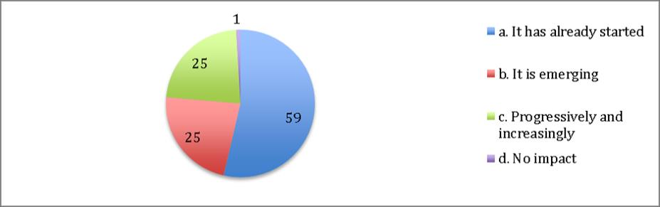
c. Do you see Artificial Intelligence & fast growing technologies impacting Hydrography? (110 votes)
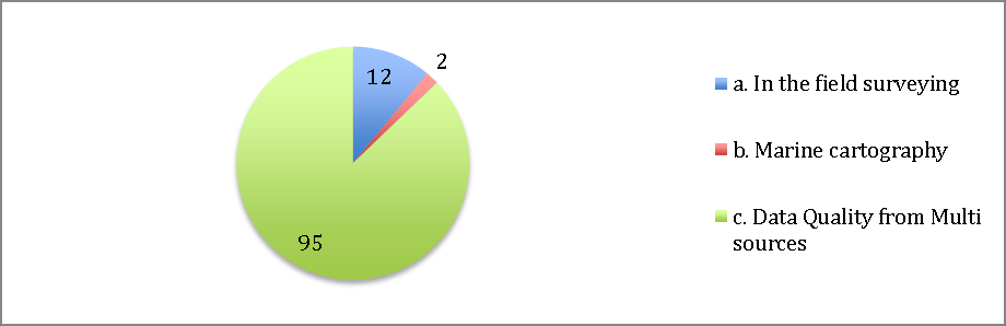
d. In the future, where do you see Hydrographer invests most of her/his time? (109 votes)
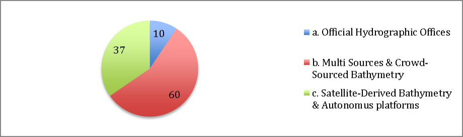
e. In the future, where do you see most Data coming from? (107 votes)
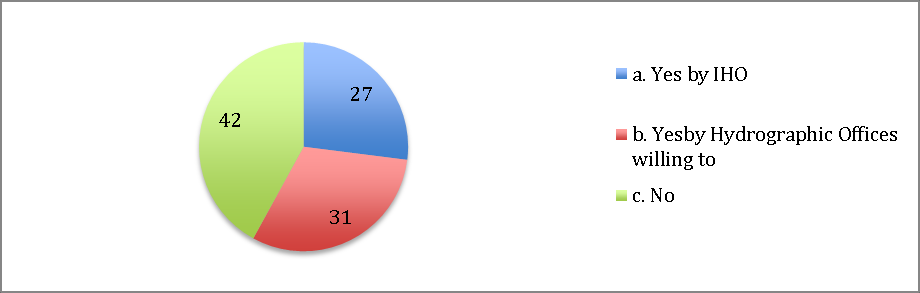
f. Do you agree to adopt “hydrospatial” officially? (100 votes)
This approach was novel in the community and allowed to draw some conclusion based on the votes and can be summarized as follow:
- 79% considered that hydrography is going through at least a very important period of change – only 4% thought it was business as usual.
- 99% indicated that training should be adapted to rapid technological changes; only 1% thought that hydrography will be same.
- 99% believed that hydrography is impacted by artificial intelligence.
- 87% saw that in the future, hydrographers will invest much more time in managing data quality from multi-sources; whereas only 11% expected the bulk of their activity would be in field surveys.
- 91% saw that in the future, data will come mostly from crowd-sourced bathymetry, satellite- derived bathymetry and autonomous platforms. 9% indicated that it would come from Hydrographic Offices (HOs).
- 58% agreed with adopting the word “hydrospatial”, either the IHO or by those HOs willing to do so. 42% did not agree to adopt the new word.
6. Conclusion
The objective and intention of this session were fulfilled. Not only did it generate a lot of discussion before and during the session, but there was also much more afterwards. It is remarkable to notice that the vast majority is engaged and mobilized towards this hydrospatial revolution. Hopefully, this article and others to come will continue to raise the issue and encourage the use of the word “hydrospatial!”
Traditional hydrography as we know it, both in the past and for the future, is essential; however, moving towards greater use of the word “hydrospatial” can not only highlight the traditional benefits and role of hydrography but will at the same time emphasize the new roles for our hydrographic geospatial data and our expertise in an exciting, modern and inspirational way.
Feedback, comments and suggestions are welcome, and expected or to join the “Hydrospatial Activists Club & Community” do not hesitate to contact: dhains@h2i.ca or write on: www.h2i.ca
7. Acknowledgments
Church, I. Chair COMREN-Article Reviewer.
Dorais, R. Canadian Hydrographic Service (CHS)-Development and Fine-tuning of Q&As for the Online voting application tool and filter board during the CHC 2020.
Ledeuil, J-C. Interdisciplinary Centre for Ocean Mapping Development (CIDCO) -Online voting application tool manager during the CHC 2020.
Ponce, R. Senior Executive Consultant-Maritime Services at Esri-Article Reviewer.
Sanfaçon, R. President Canadian Hydrographic Association (CHA)-Supported the organization of the 1st VIP Panel Session at the CHC 2020.
* One anonymous, Experienced Hydrographic Professional-Article Reviewer.
8. References
Citation from a website :
Blue Economy: https://www.worldbank.org/en/news/infographic/2017/06/06/blue-economy and https://thecommonwealth.org/blue-economy
Bibliography from a website :
IHO, MSDI Video (2018), 4 minutes, https://youtube.be/5m15KBhd9v0
Bibliography from technical material or research literature:
Haarsma, D. reporting on Jonas, M. (May-June 2017) Hydro International Magazine, Hydrography Will Be Big Contributor Filling the Digital Aquarium
Hains, D. (2017) US HYDRO Proceedings 2017, CHS: Hydrospatial Commitments!
Jonas, M. (2017) US HYDRO Conference 2017, Data Centric Hydrography – Bringing Knowledge to Action.
Osborne, M., Pepper, J. (May-June 2019), Hydro International Magazine, Will Hydrographic Geo-spatial Data Pass the fitness Test?
Ponce, R. (December 2019), 20th meeting of the Meso American & Caribbean Sea Hydrographic Commission (MACHC), A Hydrospatial System, The Next Frontier for Hydrographic Offices, Esri Global Maritime Executive Consultant
Ponce, R. (November 2019), International Hydrographic Review (IHR), Multidimensional Marine Data: The next frontier for Hydrographic Offices, Esri Global Maritime Executive Consultant
Bibliography from a Book :
Sinek, S. (2009), Start with WHY, Book, 255 pages