
Abstract
1. INTRODUCTION
Hydrographers use terms for their communication, they communicate with other hydrographers as well as with experts from other scientific disciplines. But they rarely deal intensively with the meaning of a term. With one term though, this was different recently. Suddenly, there was a discussion about the use of the term hydrospatial (e.g. Hains et al., 2021; Jonas, 2021; Ponce, 2020). I would like to take this discussion as an opportunity to show how a terminologist approaches such a term (see chapter 5). For this purpose, I present my PhD project at the HafenCity University Hamburg, in which I am investigating the terminology of hydrography from a German perspective.
In my work on the editorial board of Hydrographische Nachrichten (Journal of Applied Hydrography), I regularly notice that the various authors do not always use the same term with one and the same meaning. Mostly it is only a matter of nuance, but sometimes the sentences reveal a different understanding of the concept in important details, for example, when it comes to the question of what habitat mapping incorporates in its entirety. Then there are terms that actually have several meanings, these are the so-called homonyms. A good example is the term Bathymetrie (English: bathymetry), which has at least four different meanings in German (more on this in chapter 2.4).
Far more often, however, synonyms are used, i.e. words that mean the same thing. If an author uses several synonyms in a text – for example mainly sub-bottom profiler, sometimes the abbreviation SBP and for variety sometimes sediment echo sounder – this can lead to misunderstandings. This is because readers do not see the synonymy; and if they do not know that the terms are synonymous, they imagine something else and misunderstand the message of the text.
But even if the meaning of the terms was clear, the question arises as to which terms actually play a role in hydrography. Which terms do hydrographers need to know? And do all the words that hydrographers use actually belong to the terminology of hydrography?
I had to realise that not all terms are listed in the currently available standards, dictionaries and glossaries. There are quite a few terms in the reference books that are no longer up-to-date or that originate from other scientific disciplines. Therefore, I have decided to test methods with which the terminology can be systematically identified in order to build up a terminology database. If the methods prove useful, they could also be used to update the Hydrographic Dictionary (IHO, 2019), for example.
2. METHODOLOGICAL APPROACH
In order to be able to make the terminology available in a terminology database, terms must first be collected, then sorted conceptually and finally evaluated. The necessary methods are provided by terminology science (a good overview is provided by e.g. Arntz et al., 2014; Drewer and Schmitz, 2017; Hennig and Tjarks-Sobhani, 2016; ISO, 2019). I have chosen the following procedure:
First, I compiled a text corpus (see chapter 2.1). From the text corpus I extracted terms (chapter 2.2). I then examined which terms are synonymous (chapter 2.3), I also looked for homonyms (chapter 2.4). Hereupon, I thought about which synonyms should be used preferentially (chapter 2.5). Then I determined how often the individual terms occur in the text corpus (chapter 2.6). A further step is to determine which terms belong exclusively to hydrography and which have originated from other disciplines (chapter 2.7). It is helpful to look at existing reference books to get to know definitions and equivalents (chapter 2.8). The crucial step is then to create conceptual systems to show how the individual concepts are connected (chapter 2.9). The conceptual systems form the basis for definitions (chapter 2.10). Once the definitions are established, the next step is to search for English equivalents (chapter 2.11). The final step is to make the terminology publicly available in a terminology database (chapter 2.12).
2.1 Compiling a text corpus
First, I compiled an extensive text corpus. This text corpus serves as the basis for all investigations, especially for term extraction and frequency distribution. Since it is good practice to conduct the research in one’s native language, the text corpus initially consists only of current German papers.
I have selected all papers published in Hydrographische Nachrichten (Journal of Applied Hydrography) between 2008 and 2021 (issues 80 to 118, available at dhyg.de/index.php/hydrographische-nachrichten/hn-archiv). Hydrographische Nachrichten is the only regularly published journal for hydrography in the German-speaking world; it is published by the German Hydrographic Society (DHyG). In addition to these 39 issues, there is a conference volume published in 2018 by the German Association for Geodesy, Geoinformation and Land Management (DVW). In these altogether 40 sources, 368 German papers were published. These papers equal a total of about 2,500 standard pages (a standard page consists of 1,800 characters).
At this time, the text corpus is limited. An important requirement was that the papers should be of a certain standard and quality; this applies to papers that have been proofread by the editorial staff of a professional journal.
For the search for equivalents, I also evaluate the papers published in English in Hydrographische Nachrichten (85 in number) as well as other English publications, for example professional journals, textbooks and selected IHO publications.
2.2 Extracting term candidates
There are two ways to find out which terms occur in the text corpus: either read and mark the terms or use specialised term extraction software.
I used a component of the terminology management system Acrolinx from Acrolinx GmbH in Berlin for this task. The software enables semi-automatic detection of term candidates. Term candidates are words that have the character of terms according to the algorithms of the software. The result is a long list that can be sorted alphabetically. For each term candidate detected by the software, all sentences in which the term candidate occurs are quoted (these are the context sentences).
By no means all term candidates in the list are terms in the field of hydrography. Therefore, it was necessary to go through the list, term candidate by term candidate, in order to identify the terms relevant to hydrography and to select the most meaningful context sentences.
As an example, I explain the procedure using the first three sentences from an abstract published in German and English in issue 117:
“Nur etwa 20 % des Meeresbodens sind bislang mit Fächerecholoten kartiert worden. Größere zusammenhängende Flächen werden selten systematisch und hochauflösend kartiert. Stattdessen gibt es den Ansatz, dass Forschungsschiffe Bathymetriedaten auf Transitstrecken aufnehmen.”
“Only about 20 % of the seabed has been mapped with multibeam echo sounders so far. Larger contiguous areas are rarely mapped systematically and at high resolution. Instead, the approach is for research vessels to record bathymetric data on transit routes.”
In these sentences, the terms Meeresboden (seabed), Fächerecholot (multibeam echo sounder), kartieren (to map), Forschungsschiff (research vessel), Bathymetriedaten (bathymetric data) and Transitstrecke (transit route) occur.
The other term candidates suggested by the software, Fläche (area), hochauflösend (here translated as at high resolution) and Ansatz (here translated as approach) are not terms, they are not worth to be included in the terminology.
2.3 Recognising synonyms
Now the question arose, which of the 6,600 terms are synonymous. Synonymy is when two words have the same meaning, when they denote one and the same concept, when they stand for one and the same object. A well known example is height, elevation and altitude.
The synonymy is often obvious, for example in the case of the abbreviation AUV, which originates from English and is also common in German, and the full expression autonomes Unterwasserfahrzeug (English: autonomous underwater vehicle or autonomous undersea vehicle).
The synonymy of the terms bathymetrische Konturlinie, Höhenlinie, Isolinie, Konturlinie, Tiefenkontur and Tiefenlinie (in English depth contour; examples of other English synonyms follow in chapter 2.8) can only be recognised with prior knowledge. The corresponding context sentences prove that the different synonyms are used in the same meaning, although the terms Tiefenlinie (depth contour) and Höhenlinie (height contour) seem to denote opposite concepts.
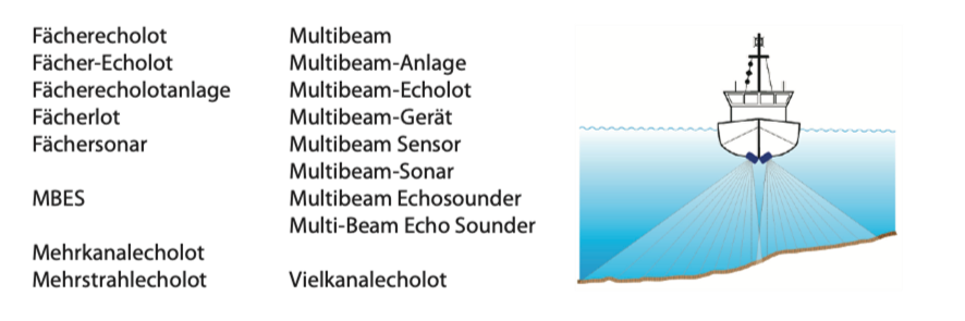
After reviewing all 6,600 terms, I gradually recognised almost 3,300 synonyms. These 3,300 synonymous terms stand for 1,200 concepts. All 6,600 terms represent about 4,500 concepts in total. For some concepts, I was only able to identify two synonyms, for a few concepts considerably more. Number one is the multibeam echo sounder (Fächerecholot), for which I was able to find another 16 German synonyms in the text corpus (see Figure 1).
2.4 Recognising homonyms
A homonym is a word that has several meanings. So the one word denotes at least two concepts, we can name different objects with it.
Identifying homonyms is not that easy. Whether a term is used in different meanings can only be recognised by reading all context sentences belonging to the term. Sometimes the whole paragraph has to be checked to get to know the full context in which the term was used.
The German term Untiefe has two meanings. On the one hand, it means the shallow place in a body of water (English equivalents are shallow or shoal). On the other hand, it means the particularly deep place in a body of water (the English equivalent is depth as in “in the depths of the ocean”; or a deep as the opposite to a shoal in a bathymetric surface or DTM). While in German the two opposing concepts can actually be denoted by one and the same word, there is clarity in English. However, shoal is also a homonym, it stands not only for the shallow place or the sandbank, but also for a school of fish.
Another example is the term Bathymetrie, which is really specific to hydrography. I was able to identify four main meanings in German: 1. It is a branch of hydrography that deals with the morphological structure or the topographical shape of the bottom of a body of water (according to some definitions it is only about the seabed). 2. In the original meaning of the word, it stands for the measurement of water depth. 3. It is also used for the measurement results, which describe the topographical shape of the bottom of the water. 4. And it is used as a synonym for seabed (only very rarely also for the bottom of inland waters). The English equivalent bathymetry is also used in various meanings.
So far, I have been able to discover 84 German homonyms among the 6,600 terms. These 84 homonyms represent at least 171 concepts.
2.5 Specifying usage
In order to avoid misunderstandings in communication, it makes sense to think about the usage of the terms. The goal is clarity of understanding. The motto is therefore: If there are synonymous terms, then only one term should be used consistently. And if a homonym is used, then always in one meaning.
The usage is differentiated between preferred, admitted and deprecated (according to ISO, 2019). Of the various synonyms, only one may be used preferentially; the usage of all others is rejected. Only exceptionally it is reasonable to allow the usage of a second synonym. This is particularly the case with common abbreviations.
The abbreviation GIS exists in both German and English. In German, GIS stands for Geoinformationssystem or Geographisches Informationssystem (or Geografisches Informationssystem). For the same concept, however, there are also the terms Räumliches Informationssystem and raumbezogenes Informationssystem with the corresponding abbreviation RIS.
In English, GIS stands for geographic information system. The terms geographical information system, geoinformation system and geo-information system are used much less frequently. Sometimes the term geospatial information system is also used. All terms mean the same thing (see Table 1).
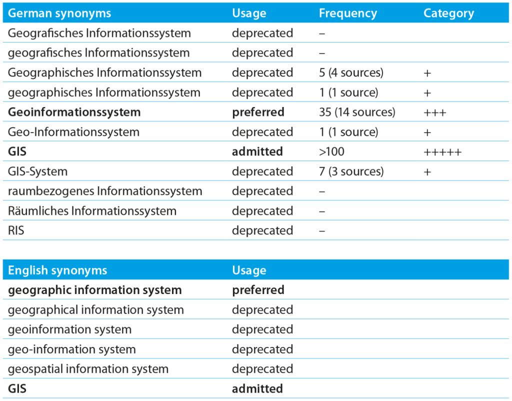
Now the question arises, which term should be used preferably besides the admitted abbreviation GIS. The decision does not have to be made arbitrarily. There are linguistic criteria. First and foremost, a term should be precise and unambiguous. In particular, it should be possible to see
directly what a compound term means. Of course, the term should also be grammatically and
linguistically correct. Furthermore, it should be used widely and readily understood (see also chapter 2.6). And it would be good if the term is easy to pronounce, which includes being as short as possible.
This is why in German the choice falls on the term Geoinformationssystem. The longer form
Geographisches (or Geografisches) Informationssystem is problematic both grammatically and orthographically. The synonyms raumbezogenes Informationssystem and Räumliches
Informationssystem are not very common in hydrography, so the abbreviation RIS is not applicable.
In English, the choice falls on the term geographic information system due to its common usage. All other variants should therefore be declared as deprecated. However, the synonym geospatial information system is noteworthy (more on this in chapter 5).
2.6 Determining frequency
The different terms are used with varying frequency. I could find some terms in the text corpus only once. For other terms, there are over a hundred occurrences in the text corpus. I therefore systematically determined the frequency. In this way, I wanted to find out which terms are really relevant.
Furthermore, the frequency can also be used for the choice of the preferred term, because it says something about the common usage (see chapter 2.5 and Table 1). Thus, I found that the abbreviation GIS occurs over a hundred times in the text corpus (category +++++). For the term Geoinformationssystem I counted 35 occurrences in 14 sources (category +++). All other synonyms occur less than ten times (category +). In this case, the frequency distribution confirms the decision on usage previously made on the basis of linguistic criteria. However, the number of occurrences may also give reason to reconsider the decision on usage.
It is interesting to see how the frequency of the approximately 5,900 terms extracted from the text corpus is distributed. A lot of terms occur only very rarely in the text corpus. And only a few terms occur very frequently.
More than 5,100 terms occur once to a maximum of ten times in the text corpus (category +).
Almost 500 terms occur eleven to 25 times (category ++). Just 174 terms occur between 26 and 50 times (category +++). 78 terms occur 51 to 100 times (category ++++). And 48 terms occur at least 101 times (category +++++).
A really surprising finding is that over 3,500 terms appear in only one source of the text corpus. These terms are obviously not very common. Often they are compound words that are formed rather spontaneously, for example: Satellitenbilddatenauswertung (in English: satellite image data analysis). A total of 2,356 terms even occur only once in the text corpus. These terms may be technical, but they are probably not really important, for example, Bodenrückstreukoeffizient (ground backscatter coefficient) or Lattenpegelablesung (stream gauge reading). The frequency distribution makes it possible to filter out the terms that are probably important. The terms in the categories ++ to +++++ are likely to be important, i.e. about 800 in number.
2.7 Assigning terminology group
A second way to identify the terms that are crucial for hydrography is to differentiate them according to terminology groups (following Roelcke, 2010, pp. 55-60). This is about the technicality of a term or concept. I distinguish between intra-subject, inter-subject and extra-subject terms.
Intra-subject terms belong exclusively to the technical language of hydrography. The intra-subject terms therefore exclusively exist because hydrography exists. Consequently, these terms are also predominantly used in internal communication between hydrographers.
Inter-subject terms originate from other technical languages, for example oceanography, hydrology, hydraulic engineering, cartography. A hydrographer must understand these inter-subject terms because they are necessary for interdisciplinary communication.
Extra-subject terms have their origin in the technical languages of basic scientific fields, for example geography, physics or mathematics. These extra-subject terms are used in many technical languages, sometimes also in the technical language of hydrography.
I have not yet completely finished assigning the terms to the three terminology groups (as of January 2022). It appears that of the approximately 6,600 terms, about 1,000 to 1,200 fall into the intra-subject terminology group. Initial estimates indicate that about half of these intra-subject terms also occur in at least two sources of the text corpus (which does not yet mean that they fall into category ++).
The following can be foreseen: of the 800 most frequent terms in the text corpus (categories ++ to +++++, cf. chapter 2.6), at best one third can be assigned to the intra-subject terminology group. In their communication – whether within hydrography or across disciplines – hydrographers use a considerable amount of terms from other technical languages. There are probably around 500 to 600 central concepts that are important for hydrography, so all hydrographers should learn them in their education.
2.8 Evaluating reference books
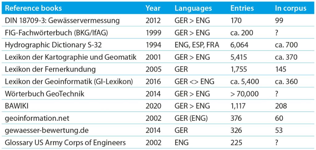
Unfortunately, there is no reference book that lists the most important intra-, inter- and extra-subject terms of hydrography. In any case, there are only a few reference books specialised in hydrography, primarily the Hydrographic Dictionary S-32 (IHO, 1994, 2019), the German standard DIN 18709-3 “Gewässervermessung” (English title: “Hydrographic surveying”) (DIN, 2012) and the FIG-Fachwörterbuch (BKG, 1999).
DIN 18709-3 was published in 2012, the standard defines 170 concepts. In addition to the German terms, partly with German synonyms, the English equivalents are often presented. It is normal that only comparatively few concepts are defined in a standard. The objective of a standardisation body is to agree on the most important concepts and terms. However, it is surprising that only 99 of the 170 concepts are mentioned in the text corpus. There are two possible reasons for this: either I did not compile the text corpus in a representative way (more on this in chapter 4); or irrelevant concepts were included in the standard. In fact, I think some entries in the standard are not closely related to hydrography, for example rechtweisend Nord (true north) and Gitter Nord (grid north).
In 1994, the IHO published the 5th edition of the Hydrographic Dictionary (IHO, 1994). It is a monolingual dictionary which at that time listed 6,064 English terms marked with IDs. The IDs were used to identify the French and Spanish equivalents in the French and Spanish versions of the dictionary, which were published somewhat later. In 2007, an appendix with ECDIS-related terms was published, about 150 in number (IHO, 2007). The content of the Hydrographic Dictionary is now available in wiki format on the IHO website (IHO, 2019). The inventory has now grown to 6,255 terms. The Hydrographic Dictionary Working Group has also published a Chinese and an Indonesian version in addition to the English, French and Spanish versions.
The Hydrographic Dictionary does not exist in German. However, there is a list of more than 6,000 word pairs in English and German. This list was compiled many years ago on the basis of the 5th edition of the Hydrographic Dictionary for internal purposes at the Federal Maritime and Hydrographic Agency (BSH). The content of the list was also accessible in a wiki on the DHyG website between 2006 and 2010 (DHyG, 2007). I have compared the German terms in this list with the 6,600 terms I have collected. Only about 700 terms are identical. Now, it may be that the list is incorrect in some places or contains synonyms that I have not yet recognised as such. Also, almost 200 more terms have been added to the Hydrographic Dictionary since 1994. Nevertheless, at best only one sixth of the terms appear in my text corpus. This can also have two reasons: either I did not compile the text corpus in a representative way; or the Hydrographic Dictionary contains a large number of terms that are now historical, or terms that are only remotely related to hydrography because they originate, for example, from navigation, meteorology, oceanography or printing.
Nevertheless, a look at the Hydrographic Dictionary was helpful. Because it gave me about 700 definitions and 700 equivalents, and from a source that can be considered reliable.
Other specialised encyclopedias, dictionaries and glossaries that I evaluate are listed in Table 2. This shows that – as far as I know – there is no reference book that defines all the essential concepts of hydrography. Most reference books cover related disciplines (for example, cartography, geoinformation, hydrology, hydraulic engineering), they mostly list terms that are inter-subject from the perspective of hydrography. Rather coincidentally, a few intra-subject terms of hydrography are listed in these reference books. These are the terms that are required for interdisciplinary communication with hydrographers from the perspective of the other disciplines.
Even if the various reference books do not list too many terms known from the text corpus, they are still valuable sources. On the one hand, the definitions can be compared, which helps to identify any divergent understanding of the terms. On the other hand, the reference books sometimes give further synonyms and English equivalents. In this way, the collection of German synonyms can be completed, and synonyms can easily be gathered in English as well.
In chapter 2.3 I identified the synonyms for Tiefenlinie (depth contour). In the text corpus I found: bathymetrische Konturlinie, Höhenlinie, Isolinie, Konturlinie, Tiefenkontur. Now, with the help of the reference books I was able to complete the collection of synonyms.
The GI-Lexikon (GI-Lexikon, 2016) lists the following synonyms for which there are no occurrences in the text corpus: Isobathe, Höhenlinie im Gewässer, Höhenlinie unter Wasser, Tiefenkurve, Unterwasserhöhenlinie. In addition, the GI-Lexikon knows the following English equivalents: bathymetric contour, depth contour, isobath, submerged contour.
The Hydrographic Dictionary provides the following synonyms: contour, contour line, depth contour, depth curve, height contour, isobath; and there is also a reference to fathom curve and
fathom line.
DIN 18709-3 knows the Tiefenlinie and the synonym Isobathe as well as the English equivalent depth contour.
After looking through all the reference books available to me, I was able to gather a total of 13 synonyms in German and 12 English equivalents. Of course, the usage must now be re-evaluated. However, I come to the same recommendation as DIN 18709-3: in German the term Tiefenlinie is preferred, in English the term depth contour.
2.9 Creating conceptual systems
When looking at the various synonyms for Tiefenlinie (depth contour), the terms with the word component Höhe (height) are remarkable, for example Unterwasserhöhenlinie (verbatim: under water height contour). In fact, the term Höhenlinie (height contour) is sometimes used, although the lines of equal depth under water are meant (five occurrences in four sources of the text corpus). In addition, there are lines of equal height that lie above a reference surface on land. These are quite rightly referred to using the term Höhenlinie (height contour).
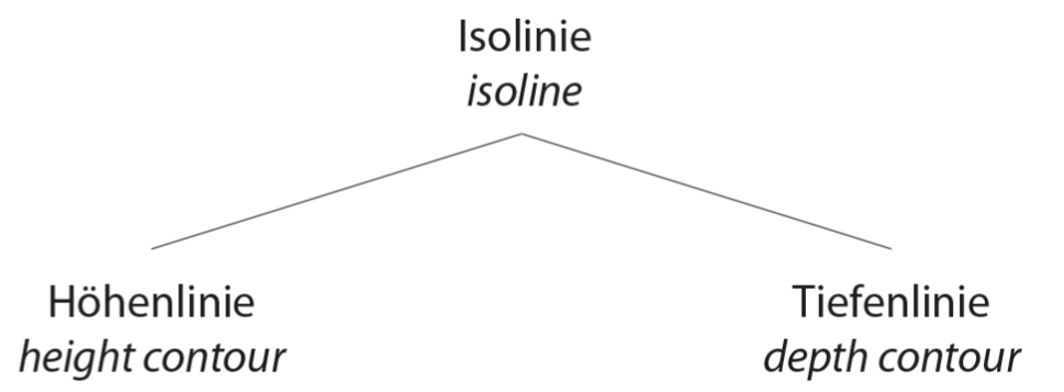
A conceptual system can be used to show how the two concepts are related. Figure 2 clearly shows that they are neighbouring concepts. The superordinate concept is roughly defined as a line connecting points that are at the same elevation level. An appropriate term for these lines would be Niveaulinie, Konturlinie or Isolinie (contour line or isoline). The common feature of all three concepts is the course of the line through points of equal height. The superordinate concept does not distinguish between height and depth, but the subordinate concepts are specific. On this basis, precise definitions can be written (see chapter 2.10).
Since hydrography also examines the course of water boundaries and the nature of the adjacent land strip, it is useful to distinguish between Höhenlinien an Land (height contours on land) and Tiefenlinien unter Wasser (depth contours under water). If both are meant, one should generally speak of Niveaulinien, Konturlinien or Isolinien (contour lines or isolines).
Excursus: The preferred term must now be defined for the superordinate concept (see chapter 2.5). In this case, I would prefer the use of Isolinie (isoline), although the term can also refer to other parameters, for example salinity (isohaline) or temperature (isotherm). The term Konturlinie (contour line) is a homonym, it also stands for the outline, thus meaning the line characteristic of a shape. The term Niveaulinie would be unambiguous, but it is quite uncommon.
A more complex conceptual system is shown in Figure 3, which shows the relationship of different echo sounders. Besides the simple navigational depth sounders and fish finders, there are surveying echo sounders and handheld depth sounders. Surveying echo sounders are divided into area echo sounders and line echo sounders. The multibeam echo sounder and the multi-channel echo sounder are subsumed under the area echo sounders. The classification criterion in this case is the areal survey as opposed to the linear survey.
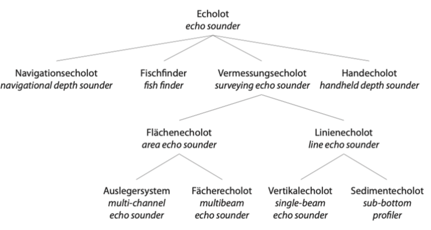
An alternative classification criterion would be the number of channels, so a distinction could be made between multi-channel echo sounders (Mehrkanalecholote) and single-channel echo sounders (Einkanalecholote). Nothing would change in the rest of the conceptual system.
To me, however, the relevance to practical application – areal versus linear surveying – seems more important than the technical aspect – several channels versus one channel.
As soon as a conceptual system shows the arrangement of the concepts, definitions can be written for all essential concepts.
2.10 Writing definitions
A definition is a brief explanation that states the specific characteristics of a concept. The definition is intended to show the relationship to other concepts. A good definition follows a certain pattern. Particularly suitable is the intensional definition (German: Inhaltsdefinition), in which, starting from an already defined superordinate concept, the limiting characteristics are named that distinguish the concept to be defined from its neighbouring concepts (Arntz et al., 2014, pp. 65-67; ISO, 2019). Much simpler is the extensional definition (German: Umfangsdefinition), where all subordinate concepts of the concept to be defined are mentioned (Arntz et al., 2014, pp. 67; ISO, 2019). By naming superordinate concepts and neighboring concepts or all subordinate concepts in the definitions, it becomes apparent which concepts make up the conceptual system.
Example 1: The definition for the depth contour (Tiefenlinie) from chapter 2.9 is: “Isoline connecting points lying at the same depth below a reference surface. Compare: height contour.”
In contrast, the height contour (Höhenlinie) is defined as: “Isoline connecting points lying at the same elevation above a reference surface (for example, sea level). Compare: depth contour.”
In both cases, the common superordinate concept is named: the isoline. The difference can be determined by the position below or above a reference surface.
For the definition of the isoline (Isolinie), a mixture of intensional and extensional definition is suitable: “In cartographic representations, a line describing the shape that connects points that lie at the same elevation level. Distinction is made between height contour and depth contour.”
Example 2: A surveying echo sounder (Vermessungsecholot) can be defined as: “An area echo sounder or line echo sounder used for surveying purposes.” (Extensional definition.)
An area echo sounder (Flächenecholot) can be defined as: “Surveying echo sounder used for areal surveying of the bottom of a body of water. Distinction is made between multibeam echo sounder and multi-channel echo sounder.” (Mix of intensional and extensional definition.)
A multibeam echo sounder (Fächerecholot) can be defined as: “Area echo sounder that measures on several channels simultaneously, with the individual beams arranged in a fan shape. Compare: multi-channel echo sounder.” (Intensional definition.)
A multi-channel echo sounder (Auslegersystem) can be defined as: “Area echo sounder consisting of several single-beam echo sounders arranged side by side and attached to an arm, especially suitable for surveying shallow waters. Compare: multibeam echo sounder.” (Intensional definition.)
A definition should convey what constitutes the concept. It should locate the position of the concept in a conceptual system and show the relationships to other concepts. This is best achieved if only preferred terms are used in the definition (in the latter cases, for example: bottom of a body of water, single-beam echo sounder).
Anyone who wants to find out the meaning of a term is interested in a definition. The definition provides the explanation. If a term is a homonym, there are several definitions. However, definitions also play an important role with regard to translation into other languages, as they make it possible to agree on suitable equivalents with experts from other countries.
2.11 Searching equivalents
I was already able to collect equivalents when evaluating reference books (chapter 2.8). How-ever, with regards to the 800 most frequently occurring terms in the text corpus, the number of findings was limited. Therefore, the question is what possibilities there are to find equivalents besides consulting dictionaries.
A very good source are (German) papers in which the authors provide English equivalents, which is not at all uncommon. The same authors have often published papers in English on the same topic, which are worth browsing.
Even better are parallel texts, which are texts that exist in two languages. If the texts are transla-ted professionally, they can be evaluated sentence by sentence, which makes it quite easy to identify the equivalents (cf. the example with the abstract in German and English from chapter 2.2).
A less time-consuming method is to use translation tools based on artificial neural networks. These translation tools have knowledge of grammar, they are linked to numerous dictionaries and they have been fed with vast amounts of parallel texts. However, it can be assumed that these translation tools neither know dictionaries from the field of hydrography nor have they been trained with hydrographic literature. In this respect, the translations must not be taken over
unchecked.
I will use three examples to show how I gather the equivalents.
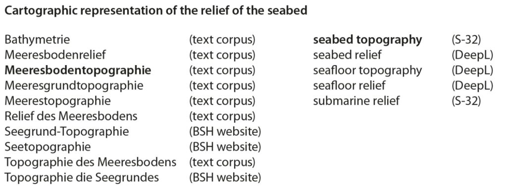
Example 1: The first example is about the topography of the seafloor, i.e. the cartographic representation of the relief, which is called Meeresbodentopographie in German. However, there are some synonyms (Figure 4), for example Meeresbodenrelief or Seegrund-Topographie, but also Bathymetrie (see chapter 2.4). Looking for equivalents, I checked the Hydrographic Dictionary and found seabed topography and submarine relief in it. For both English equivalents there are references in the English papers of Hydrographische Nachrichten. Nevertheless, I also used the machine translation service of DeepL, a deep learning company (www.deepl.com). DeepL suggests seabed relief, seafloor relief and seafloor topography. However, these are rather uncommon words for which I could find no evidence in the text corpus; but seafloor topography is widely used in the GEBCO community.
Example 2: The second example is about sounding with a single -beam echo sounder, where profile surveys are taken along a profile line (along transverse profiles or longitudinal profiles) (Figure 5a). In German, this is called Linienpeilung. This term is also mentioned in DIN 18709-3. As an equivalent, the standard gives “lines of sounding”. This seems inappropriate to me, because it’s not about the lines, but about the sounding. Therefore, line sounding would probably be more appropriate. Line survey is also a good choice, because it goes well with area survey. However, I cannot find any evidence for these equivalents in the text corpus. Therefore, the appropriate equivalent still has to be verified by native speakers of English.
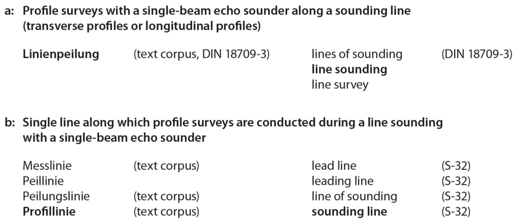
A line of sounding (singular) could be the single line along which profile surveys are conducted during a line sounding with a single-beam echo sounder. Thus a single-beam echo sounder generates a single line of soundings along a sounding line during a line sounding. Looking at this definition of line of sounding or sounding line, the German synonymous terms Messlinie, Peillinie, Peilungslinie and Profillinie come to mind (Figure 5b). Three of these terms occur in the text corpus, but not in the German-English dictionaries. So I had to look up the appropriate equivalent in the Hydrographic Dictionary again. There I found four entries: line of sounding and sounding line, but also references to lead line and leading line (whereby it is questionable whether the last two terms denote the same concept). The preferred term could be sounding line, but even this choice has to be confirmed by hydrographers whose mother tongue is English.
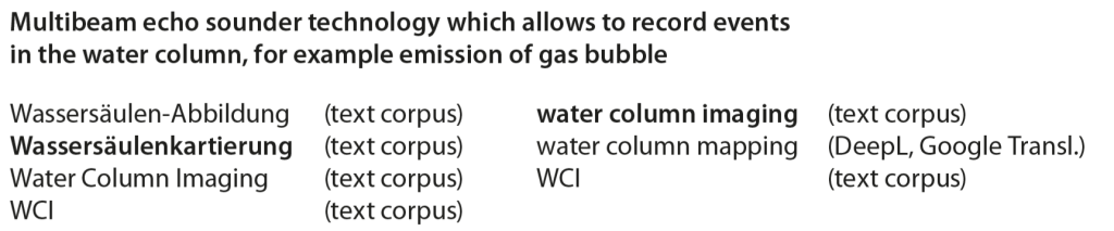
Example 3: The third example involves a relatively new technology. The events in the water column are recorded with a multibeam echo sounder, for example, to show the emission of gas bubbles (Figure 6). In German, the term Wassersäulenkartierung has become established. It is also often referred to as WCI, which is the abbreviation of Water Column Imaging. This English term also occurs very often in German texts. In this case, it is quite easy to determine the English equivalent including the admitted abbreviation.
To test the performance of machine translation tools, I entered Wassersäulenkartierung into DeepL and Google Translator. Both suggest water column mapping as the English equivalent. The expression also fits well with the German term, but it is not used in English.
The examples should illustrate that it is not trivial to find equivalents, especially to determine the preferred English equivalent, which is also due to the fact that there tend to be even more synonyms in English than in German. It will not work without the help of experts from English-speaking countries who confirm the equivalents on the basis of the definitions.
However, the examples should also show that important concepts and the associated German and English terms are not yet listed in any reference book.
2.12 Providing terminology in a terminology database
A terminology database that can be accessed online is a convenient way to make knowledge on concepts and terms available. A professional terminology database has several advantages over an alphabetically organised reference book. The terminology database must fulfil two essential criteria: it must be concept-oriented and term-autonomous (Drewer and Schmitz, 2017, pp. 129-131; Arntz et al., 2014, pp. 240-241). Thanks to its concept-oriented structure, the terminology database provides all information on a concept at a glance. This information includes the definition, possibly an illustration, the terminology group (intra-, inter- or extra-subject) as well as all synonyms and equivalents. Thanks to the term autonomy, each term has its own information, for example on usage (preferred, admitted, deprecated), frequency and up-to-dateness. A context sentence and the associated source can also be noted. I use the terminology database crossTerm from Across Systems GmbH in Karlsbad, Germany.
Figure 7 shows the interface of the terminology database as used by a terminologist for management. The upper third contains the definition, in the middle section the German terms are listed on the left and the English equivalents on the right. The preferred term is marked with a green symbol. In the lower third, the detailed information on the currently selected term is provided.
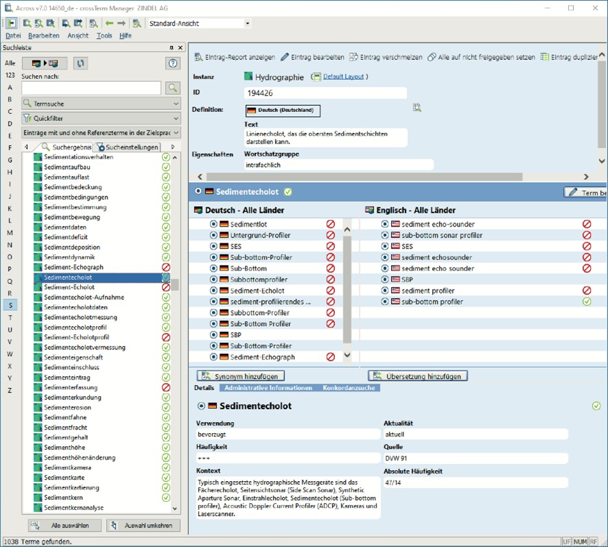
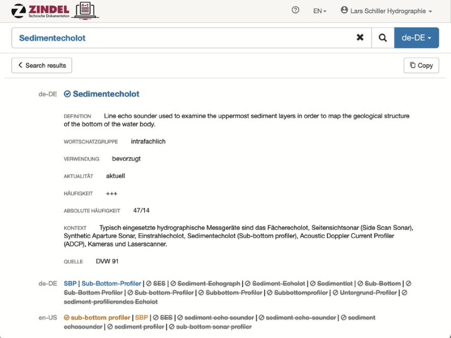
Figure 8 shows the same entry, but in the search interface. In the detailed view, all information on the concept is visible (definition) as well as the information on the searched term (usage, frequency, up-to-dateness, context sentence, source). This interface should then be accessible to everyone via an internet browser.
3. FIRST RESULTS
After the steps completed so far, the scope of the terminology of hydrography can be roughly estimated. The approximately 6,600 terms compiled so far are in the same range as the number of terms listed in the Hydrographic Dictionary (approximately 6,250). However, this is probably more of a coincidence, as the common intersection is just 700 terms.
New intra-, inter- and extra-subject terms are still added with each new term extraction. However, there are not as many per issue of Hydrographische Nachrichten as there were at the beginning. How many new terms are included in a new issue depends on the number of papers and the main topic of the issue. On average, however, a decreasing trend is discernible. In the last issues, between 50 and 100 new terms were added. The fact that terms are still being added that were not used in the other issues indicates that there is no end in sight so soon. As long as hydrography continues to develop, there will always be new concepts and corresponding terms.
Of the 6,600 terms, approximately 1,000 to 1,200 are intra-subject (this number must still be considered preliminary in January 2022). However, a lot of these intra-subject terms occur very rarely in the text corpus. Only about 300 intra-subject terms have a total of at least eleven occurrences in at least two sources of the text corpus. Every hydrographer needs to know these 300 intra-subject terms.
But hydrographers also need to know inter- and extra-subject terms in order to be able to communicate with each other and across disciplinary boundaries. Taken together, I was able to identify about 500 inter- and extra-subject terms that occur at least eleven times in the text corpus.
Among these 300 intra-subject and 500 inter- as well as extra-subject terms, there are also synonyms. The 800 terms probably represent 500 to 600 central concepts of hydrography.
These central concepts should be listed in a reference book – including definition, preferred German term, preferred English equivalent and all deprecated German and English synonyms. However, there is no reference book that lists these central 500 to 600 concepts. Not even the much more comprehensive Hydrographic Dictionary knows the entirety of these concepts.
In any case, the reference books available have clear weaknesses. Their biggest shortcoming is that they are organised in a term-oriented manner; the terms are sorted alphabetically, often without internal references to synonymous terms that begin with a different letter. This makes it difficult, if not impossible, to find out all the information about a concept. The concept-oriented presentation in a terminology database, on the other hand, makes it possible to grasp everything at a glance. Above all, it allows to make a statement about the number of concepts.
It is particularly striking that the reference books contain many terms that are obviously unrelated to hydrography and thus rather irrelevant for hydrographers. Of the 170 concepts defined in DIN 18709-3, just 99 are relevant to hydrography. At least, the terms for the other 71 concepts do not occur in the text corpus. However, other important entries are missing. The Hydrographic Dictionary also contains a large number of terms that are not relevant to hydrography. One might think that there were no criteria as to which terms belong to hydrography. I have learned from members of the Hydrographic Dictionary Working Group that these non-hydrography related terms were deliberately included in the Hydrographic Dictionary and should remain there. However, the definitions were not worked out by the Working Group, the definitions are taken as provided by the relevant specialisation and included without amendment. It is not clear which concepts and terms this concerns.
The evaluation of the reference books has shown that, on the one hand, not all terms are listed in the reference books, and certainly not in just one reference book. On the other hand, there are also many terms in the reference books that have no real connection to hydrography, are historic or have long been obsolete.
Of course, there is nothing wrong with leaving historic terms in a reference book or database.
Especially if there are no space restrictions, as in a terminology database, rare and obsolete concepts as well as obsolete terms can be included, but they should be marked accordingly. Even the 2,356 terms that are represented in the text corpus with only a single occurrence each remain in the terminology database. Only in this way it is possible to recognise them when they are encountered in an expanded corpus of texts.
4. DISCUSSION
In engineering, it is common to give clear numbers. This linguistic project is more about approximate quantities. The aim of the study is to get a sense of how extensive the terminology of hydrography is. If one number is crucial, it is how many concepts play a role in hydrography. In the text corpus examined so far, I was able to identify 4,500 concepts. But I think only about 500 to 600 concepts are really relevant. How significant are these numbers? To assess this, I critically discuss the procedure described in chapter 2.
Text corpus: Of course, the text corpus has weaknesses. It is rather one-sided because it consists mainly of the issues of Hydrographische Nachrichten. However, the papers were written by a wide variety of authors, so that the text corpus shows correspondingly different styles of thinking and expression. Nevertheless, the text corpus is not particularly extensive. This raises the question of what happens when the amount of text is doubled, whether it then also contains twice as many concepts and terms. This is exactly the question I will be able to answer one day, precisely because I started with a relatively small text corpus.
Once I have completed the research described in chapter 2, I will gradually expand the text corpus. It grows with each issue of Hydrographische Nachrichten and with each conference volume. If one day a book on hydrography should appear in German, I would also use that for the text corpus. Other types of texts should also be represented in the text corpus, for example user manuals, work instructions, marketing documents.
The text corpus consists mainly of German texts. This is necessary in the context of this initial study because the rules of terminology science dictate that terminology should be worked out in one’s mother tongue. A side effect is that term extraction leads to better results more quickly, which is due to the peculiarity of the German language. However, there is no reason why the text corpus should not be expanded later to include English texts; after all, there are much more English publications.
Selection of term candidates: For term extraction, I used software whose algorithms for selecting term candidates are not known. The software presents term candidates that have a term character. It takes into account, for example, the part of speech, the length of a word, the frequency in the text and the position of the word in the sentence. Studies have shown that the described procedure – automatic term extraction followed by manual validation of the proposed term candidates – leads to the best result (Janke, 2013).
The question remains whether I have selected the terms sensibly during validation. The iterative procedure almost guarantees that all terms will be found one by one. This is because a term that was ignored the first time it appeared, would be presented again as unknown at the next term extraction. Thus, terms that appear in more than one source are almost inevitably discovered.
But it is possible to be overambitious in the choice of terms. This would explain why I have found so many terms for which can only be proven a single reference. It is interesting to note that very many of the very rare terms are actually intra-subject. Often these terms are rare synonyms, but often they are spontaneous word creations. But even these rare terms are rightly in the terminology database. Because obviously they are used, and therefore there will always be users of the terminology database looking for them. The more entries there are in the terminology database, the higher the probability that users will find answers.
Synonyms: So far, I have been able to identify about 1,200 concepts to which I could assign almost 3,300 German synonyms. So, besides 1,200 preferred terms, there are almost 2,100 deprecated synonyms and a few admitted synonyms. On average, therefore, two to three terms are known for these concepts.
It is very likely that I did not recognise the synonymy in every case. In addition, there are probably still numerous synonyms that do not appear in the text corpus.
Homonyms: So far, I have been able to identify 84 German homonyms. It is very likely that there are more homonyms. Identifying them from context sentences is laborious and difficult, but important, because homonyms complicate communication. In addition, there are likely to be some terms that, although used in hydrography in only one meaning, have a different meaning in rela-ted disciplines.
Determining usage: Despite the linguistic criteria for the appropriate preferred term, the determination is subjective (therefore, cooperation with a working group would be desirable, in order to agree on the usage of the terms). This does not matter, however, because the determination could easily be changed if good arguments were presented. In any case, consistent use of the preferred term improves communication.
Frequency: The numbers on the frequency of a term and on the frequency of a concept (for which sometimes the preferred term is used, sometimes the rarer deprecated synonyms) depend directly on the text corpus. The larger the text corpus, the more representative the frequency numbers become. Nevertheless, it is significant whether a term occurs in 20 sources, for example georeferenziert (georeferenced), GPS (GPS); in five sources, for example Gashydrat (gas hydrate), Generalisierung (generalisation), GPS-Antenne (GPS antenna); or only in one source, for example Gewässerbettbreite (stream bed width), GPS-Störung (GPS malfunction).
Terminology group: The approach (which goes back to an idea by Roelcke, 2010) of differ-rentiating within the terminology according to intra-, inter- and extra-subject terms seems to be suitable for identifying the essential concepts and terms of hydrography in combination with the frequency distribution. However, it is sometimes a subjective decision to assign a term to a speci-fic terminology group. The criteria for the assignment need to be defined more clearly so that others also come to the same conclusions.
Reference books: So far, I have looked for definitions, synonyms and equivalents in monolingual German, in German-English and in monolingual English reference books. I selected what I could find in libraries and on the internet (see Table 2). It is possible that there are other and better reference books that are worth evaluating. I would therefore be grateful for information on other reference books.
Conceptual system: Conceptual systems enable the structuring of knowledge. Surprisingly, there are different approaches to arrange concepts in a conceptual system, not only abstract concepts but also concepts of physically existing objects. I first try to illustrate the German understanding of a concept. Of particular interest is whether there are culturally different approaches to arrange concepts. Conceptual systems that are created independently of each other from a
German and an English perspective make it possible to identify terminological gaps. A terminological gap can be both a missing term and a concept that is missing in a culture (Arntz et al., pp. 158-162).
A few examples: In German, one speaks of a Crawler, because there is no German equivalent. The Bundeswasserstraßenkarte only exists in Germany; it is a map that shows the federal waterways. While in English a distinction is made between ports and harbours, in German there are only Häfen.
Definitions: The definitions are written on the basis of the conceptual systems. They are simple terminological definitions that are limited to the essentials. An important goal is to use only the preferred terms in the definitions so that clear cross-references can be made to other
concepts and their definitions. This task is hardly manageable with regard to the totality of concepts alone, which is why I must initially limit myself to the 500 to 600 concepts that I consider particularly relevant.
Equivalents: Searching for equivalents in a foreign language is a tricky business. My
assignments will be incomplete, possibly even wrong in some places. The work can only be done reliably with native competence in English. Therefore, it is important to engage native speakers of English for quality assurance and supplementation in due course.
Furthermore, it is important to pay attention to the sublanguage (for example, British English or American English). On the one hand, there are differences in spelling, on the other hand, there are sometimes significant linguistic differences.
Terminology database: The terminology database I use fulfils the most important requirements of terminologists, it is concept-oriented and term-autonomous. From a terminologists’ point of view, however, a few data fields are missing, for example for the genus or the part of speech (such as noun, verb and adjective). From the point of view of a hydrographer searching for a term in the terminology database, however, the information should be sufficient.
A beta version of the terminology database will soon be accessible on the internet. Experts will then be able to give feedback and make suggestions for new concepts and terms to be included. However, they are not allowed to edit the entries directly according to the wiki principle. Instead, the comments must be centrally checked and terminologically edited. This is how the feedback flows in. The changed or added entries are visible in the terminology database without delay, so the content is always up-to-date.
5. THE EXAMPLE HYDROSPATIAL
Using the English term hydrospatial as an example, I would like to show how a German-speaking terminologist approaches such a term.
First approach: When I saw the term for the first time, I thought it was a motivated adjective whose meaning is immediately obvious. It is about water data that have a spatial reference. The adjective refers to this water data. Then I asked myself what the German equivalent might be. I had to realise that the term cannot be translated directly. The one-to-one translation is gewässerräumlich. But nobody would say that; such a word formation does not correspond to the way a German speaker thinks.
Second approach: I compared the adjective hydrospatial with the adjective geospatial built on the same pattern. For example, I already knew the term geospatial information system (see chapter 2.5); the preferred term is geographic information system, the admitted abbreviation is GIS. A GIS is about geospatial information, in German one would say: raumbezogene Informationen. Appropriately, hydrospatial information could be managed in a hydrospatial information system (abbreviated: HIS). In German, one would say: gewässerbezogene Informationen. I have used the German adjective myself before, in my definition of hydrography presented in 2012 (Schiller et al., 2012; English versions: Schiller, 2012, 2015). The differentiation between geospatial and hydrospatial information is much better than that between geographic and hydrographic information or that between topographic and hydrographic information. Geospatial and hydrospatial are complementary. Of course, it can also be understood in a different way, like hydrospatial is a part of geospatial.
Third approach: I followed the discussion on hydrospatial and read the article “So … what is hydrospatial?” again to better understand the argumentation (Hains et al., 2021).
The authors want to express something new. Hydrography is more modern today for a variety of reasons, they say, and this can be clarified with a new word. The authors write, “hydrospatial is not in opposition to hydrography, but rather an expansion of it”. So it is about an expansion, that becomes clear. However, I do not understand how an adjective (hydrospatial) can be an expansion of a noun (hydrography). Nor do I understand the next sentence, hydrospatial is “an articulation of a more specific scope”. An expansion is rather about a “more comprehensive scope” or a “wider scope” than before.
I can well understand the argumentation that with geospatial there is a term that designates the spatial reference, but that this term leads to thinking only of the solid earth instead of the water bodies (“it has in practice been used more to represent first and foremost the DRY SIDE or landmass rather than the WET SIDE or water bodies”). Therefore, a term is needed that directly refers to the water body. Although the term “marine geospatial” exists, it refers more to the sea. To
include inland waters, “marine and aquatic geospatial” would be more appropriate. But hydrospatial is far better. All this makes sense.
Then, however, the authors try to explain the term hydrospatial by paraphrasing the definition of hydrography: “Hydrospatial ‘is the branch of applied sciences which deals with (…)’.” No matter what one thinks of what follows, the attempt must be considered a failure for formal reasons. That, at least, is the verdict of a terminologist who claims that an adjective cannot be defined like a noun.
A terminologist would formally agree if it read: “Hydrospatial sciences are the branch (…).” Subsequently, it could read: “Hydrospatial denotes data and information related to hydrospatial sciences.”
Then there would be two concepts, hydrography and hydrospatial sciences, and the differences would have to be clearly worked out. But if I understand the explanations correctly, the authors would be quite happy if one day the new term hydrospatial replaced the old term hydrography. The authors obviously have only one concept in mind.
Fourth approach: Hydrography has already experienced several paradigm shifts. It started with the point-by-point measurement of water depth with a hand-held lead line. Then, after the invention of the echo sounder (which at that time was not called single-beam echo sounder), linear surveys were carried out. Later even areal surveys were carried out, whether with multibeam echo sounders or laser scanners. The sciences continue to develop, new technologies emerge, methods change – but the object of investigation remains the same. In the case of hydrography, these are the surface waters of the earth. (To be correct: At the IHO, there was a considerable expansion of the concept with regard to the object of investigation. For a long time, the IHO found it difficult to include inland waters in the definition.) Despite the many revolutions in the history of science, the names of the sciences remained the same. So I don’t see any reason to rename hydrography. The term hydrography continues to denote an independent concept.
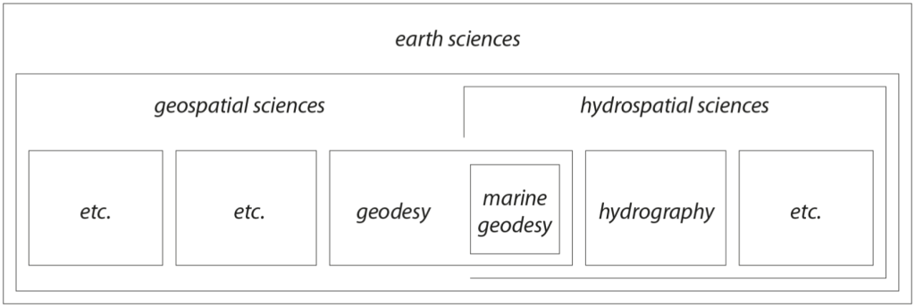
Fifth approach: Hydrospatial sciences could also be an individual concept. I wonder how hydrography and hydrospatial sciences can be represented in a conceptual system (Figure 9). At the top there are the earth sciences. Earth sciences include, for example, geodesy, cartography, geoinformatics, geography, geology, geophysics, hydrology, oceanography, glaciology, but also hydrography. In all these disciplines, spatial reference plays a crucial role. Therefore, they can be summarised well with the term geospatial sciences (for which there is no equivalent in German, it is a terminological gap). A subset of the geospatial sciences could be the hydrospatial sciences. These disciplines have water bodies as their object of investigation.
The hydrospatial sciences clearly include oceanography, which deals with the sea, and hydrology, which deals with inland waters. But also hydrography, which examines all the surface waters of the earth. Geodesy can be assigned to both hydrospatial and geospatial sciences; marine geodesy, in turn, is a part of geodesy that is solely subordinate to hydrospatial sciences. Disciplines such as geology and geophysics are located on both sides, as is cartography.
Sixth approach: The hydrospatial sciences provide hydrospatial data and information. Hydrography only provides hydrographic data and information. But there is much more water-related data and information: Oceanography provides oceanographic data and information, hydrology provides hydrologic data and information. I therefore find it quite logical to provide these data and information in their entirety: in a hydrospatial information system
The adjective hydrospatial aims at the totality of water-related data and information. The adjectives oceanographic, hydrologic and hydrographic each describe only a part of the whole. Hydrographic is thus a subset of hydrospatial.
Summary: I think it is a good idea to talk about hydrospatial data and information. The new expression is well understood and underlines the importance of this data and information. However, there are still hydrographic data and information – and these are no less valuable just because they are labeled with the adjective hydrographic. I am convinced that hydrographers would be in a much better position than the representatives of all other hydrospatial sciences to prepare, manage and present the entirety of hydrospatial data and information – for example in a hydrospatial information system. This is, by the way, exactly what I expressed in my definition of hydrography, unfortunately without using the adjective hydrospatial.
6. OUTLOOK
If people do not know a term, they have to look it up. Nowadays, people usually search the internet for a definition. But search engines do not always deliver relevant hits. It is better to look it up in a specialised online terminology database. There one can also find answers if one is interested in an equivalent to express something in another language. Or if one does not understand individual terms in a text written in a foreign language. Or if one is looking for a recommendation on which synonym to prefer.
Such a concept-oriented terminology database will be available soon. For the first time, it will
contain a significant number of German hydrographic terms. English equivalents will also be
included. And theoretically, further languages could easily be added thanks to the concept-oriented representation.
The knowledge anchored in the terminology database should help to improve communication. As soon as terms are used uniformly, as soon as there is no longer synonymy in texts, as soon as a homonym is only used in one meaning, comprehensibility increases.
The content of the terminology database can be used to check texts. Already today, there is
software that marks every deprecated term in texts and suggests the preferred term instead. Such improved texts will significantly improve written communication. In the foreseeable future, the necessary software will be easily accessible.
The content of the terminology database can also be used for machine translation. Even if there is a deprecated synonym in the original text, the preferred equivalent is used in the translation.
In general, synonyms and homonyms are a real challenge for computerised systems. What
humans understand with their sense for nuances and linguistic subtleties, computerised systems are far from understanding. Knowledge about the relationships between concepts, as well as knowledge about the relationships between synonyms and about equivalents, enables specialised applications, for example the IHO Registry, and also AI applications. AI cannot acquire knowledge of concepts and terms on its own, but if fed with information from the terminology database, it will be able to process language data.
7. REFERENCES
- Arntz, R., Picht, H. and Schmitz, K.-D. (2014). Einführung in die Terminologiearbeit, 7th ed., Olms, Hildesheim.
- BKG (1999). FIG-Fachwörterbuch – Benennungen und Definitionen im deutschen Vermessungswesen mit englischen und französischen Äquivalenten, Band 11: Hydrographische Vermessung, Bundesamt für Kartographie und Geodäsie, Frankfurt am Main.
- DHyG (2007). DHyG Wiki/Hydrographisches Wörterbuch, www.dhyg.de/joomla/index.php?option=com_mambowiki, last accessed: 14 November 2010.
- DIN (2012). 18709-3: Begriffe, Kurzzeichen und Formelzeichen in der Geodäsie – Teil 3: Gewässervermessung/Concepts, abbreviations and symbols in geodesy – Part 3: Hydrographic surveying, Beuth, Berlin.
- Drewer, P. and Schmitz, K.-D. (2017). Terminologiemanagement – Grundlagen, Methoden, Werkzeuge, Springer Vieweg, Berlin.
- GI-Lexikon (2016). Geoinformatik-Lexikon der Universität Rostock, www.geoinformatik.uni-rostock.de/lexikon.asp, last accessed: 31 January 2022.
- Hains, D., Ponce, R., Oei, P., Gülher, E., Pang, P. Y., Cove, K., Cawthra, H. C., Bergmann, M. and Picard, K. (2021). So … What is hydrospatial? International Hydrographic Review, No. 25, pp. 115–122.
- Hennig, J. and Tjarks-Sobhani, M. (2016). Terminologiearbeit für Technische Dokumentation, 2., grundlegend überarbeitete Auflage, Schriften zur Technischen Kommunikation, Band 21, tcworld, Stuttgart.
- IHO (1994): Hydrographic Dictionary, Part 1, Volume 1, English, Special Publication No. 32, 5th ed., IHO, Monaco.
- IHO (2007). Hydrographic Dictionary, Glossary of ECDIS Related Terms, Volume 1, English, Special Publication No. 32, Appendix 1, IHO, Monaco.
- IHO (2019). S-32 IHO Hydrographic Dictionary, http://iho-ohi.net/S32/engView.php, last
accessed: 31 January 2022. - ISO (2019). 1087: Terminology work and terminology science – Vocabulary, ISO Online Browsing Platform, https://www.iso.org/obp/ui/#iso:std:iso:1087:ed-2:v1:en.
- Janke, R. (2013). Anforderungen an die Terminologieextraktion – Eine vergleichende Untersuchung der Bedürfnisse von Terminologen, Technischen Fachübersetzern und Technischen Redakteuren, Hochschulschriften, Band 20, tcworld, Stuttgart.
- Jonas, M. (2021). How to use the Term Hydrospatial? Hydro International Web Site Article posted on 2021/01/26, https://www.hydro-international.com/content/article/how-to-use-the-term-hydrospatial
- Ponce, R. (2020). Hydrospatial and the Marine Environment. Hydro International magazine, https://www.hydro-international.com/content/article/hydrospatial-and-themarine-environment.
- Roelcke, T. (2010). Fachsprachen, 3., neu bearbeitete Auflage, Erich Schmid Verlag, Berlin.
- Schiller, L. (2012). Die Identität der Hydrographen, Hydrographische Nachrichten, No. 92, pp. 6-9.
- Schiller, L., Böder, V. and Schenke, H. W. (2012). The Position of Hydrography in a System of Sciences – A Comprehensive Definition and Systematic Subdivision of the Discipline, Proceedings of FIG Working Week 2012, Rome.
- Schiller, L. (2015). What exactly is hydrography? The IHO offers an abstract definition only. It is high time for more graphicness, Hydrographische Nachrichten, No. 100, pp. 59-62.
8. Author Biography
Lars Schiller works at ZINDEL AG in Hamburg, Germany, as a member of the management board. At this service provider for technical documentation he has gained experience as a technical writer and as a terminologist over the past 15 years.
He is also editor-in-chief of Hydrographische Nachrichten (Journal of Applied Hydrography) and a member of the board of the German Hydrographic Society (DHyG).
Lars studied Geodesy and holds a Master’s degree in Hydrography (Cat A) of HafenCity University (HCU) in Hamburg.