
With National Science Foundation funding, TCarta Marine launched Project Trident to re-imagine satellite-derived bathymetry (SDB) methods for greater speed, scale and extensibility. By incorporating AI and cloud technology in its workflows, the company created platforms designed to process large volumes of data far more rapidly than ever before. Newly scalable SDB techniques have enormous potential to help address urgent needs for shallow-water bathymetry in the Meso American- Caribbean Sea region and beyond.
After Hurricane Dorian tore through the Bahamas in 2019, the delivery of supplies to devastated areas was vital. But working with 150-year-old coastal mapping charts to plan the approach and landing on one of the hardest-hit islands, Great Abaco, slowed the process and posed risk for relief vessels. After the event, TCarta produced satellite derived bathymetry (SDB) for the area using methods available at the time, but the urgency of the need had passed.
In 2020, a record-breaking number of named storms—those with top winds of 39 miles per hour or greater—hit the Atlantic Basin. These included Hurricane Isaias, which barreled down to strike the Bahamas region early in the season. In the year that passed between the storms in the Bahamas, TCarta advanced its SDB solutions and workflows significantly in terms of scale and technique; these developments proved critical in producing SDB as Hurricane Isaias was gathering strength.
TCarta rapidly processed more than 400 Sentinel-2 images of the area, using a scalable SDB method to produce 140,000 square kilometers of 10-meter resolution data within a short timeframe. The team extracted millions of Ice Cloud and Land Elevation satellite (ICESat-2) points to inform and validate multiple optically-derived SDB algorithms, quickly producing the bathymetry model to provide operational support.
In partnership with Esri, TCarta shared the updated coastal modeling via the Caribbean GeoPortal, providing vital geospatial information on-the-ready for disaster preparedness, response, and relief efforts. Fortunately, Isaias’s threat didn’t fully materialize, and the storm passed with relatively little impact on the region. However, the dataset remains a valuable planning resource for organizations involved in disaster preparedness in the region.
With extreme environmental events likely to occur with greater frequency, the need to gather and compile up-to-date coastal bathymetry data in the Meso American- Caribbean Sea region before storms strike is pressing. Challenges and limitations in deploying traditional and airborne surveying techniques previously prevented data gathering at the scale required. However, with recent advancements in SDB, it’s now possible to measure and model vast shallow-water areas far more quickly than ever before.
1. Project Trident: innovating and expanding SDB
In 2018, with National Science Foundation (NSF) Small Business Innovation Research (SBIR) Phase I funding, TCarta Marine launched its multi-pronged remote sensing, hydrographic, and data science initiative, Project Trident, to re-imagine SDB methods for greater speed and scale. The initial phase focused on combining a suite of shallow-water bathymetry techniques with deep learning, machine learning, and computer vision technology to improve SDB accuracy, fuse methodologies, automate production, and extend use across variable water conditions.
During Phase I, TCarta also extended stereo photogrammetry—an approach traditionally applied in terrestrial settings—to marine environments, creating stereo photogrammetric bathymetry (SPB). The technique processes high-resolution WorldView satellite data, combining multiple overlapping images of a subsurface feature—such as a rock or reef—to calculate precise geospatial location and, ultimately, water depth for calibrating SDB algorithms. By incorporating computer vision into the stereo-photogrammetric workflow, TCarta automated and accelerated the method to rapidly produce hundreds of precise calibration points for SDB.
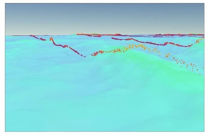
Participating in NASA’s Applied User program for ICESat-2, TCarta conducted a global hydrographic data validation process to determine the accuracy of the coastal water depths derived from the ATL03 data points, which are collected across surfaces in tightly-spaced parallel lines. The extraction of these points was far more scalable and globally extensible than SPB, making it a superior technique for Project Trident’s goals.
2. Phase II: SDB at scale
In 2019, TCarta received a Phase II continuation of Project Trident for an additional two years to implement and commercialize its innovations in SDB. The team continued its efforts, which included developing an innovative multi-sensor SDB technique integrating space-based laser (SBL) bathymetry to inform SDB algorithms as well as to validate the resulting bathymetric surfaces. Launched by NASA in 2018, ICESat-2 is equipped with an onboard laser system to reflect beams off the Earth’s surface, allowing researchers to calculate elevation. Though intended to measure polar ice and tree canopies, the technology’s potential application for coastal bathymetry was evident.
In 2020, the TCarta team developed an application to streamline processing of ICESat-2 data and apply a proprietary deep-learning algorithm. This powerful solution can derive millions of highly accurate seafloor measurements for SDB validation and calibration in a fraction of the time previously required to manually extract a few thousand points.
3. Largescale SDB in the Caribbean.
Containing one of the world’s largest continuous shallow-water expanses, the Lucayan Archipelago offered an ideal environment for deploying, validating, and continuing to refine Trident work-flows. A widely explored SDB testbed, the archipelago is located in the western North Atlantic Ocean and encompasses broad expanses of bright sandy seafloor, coral reef and pinnacles, and patchy seagrass and microalgae.
TCarta analysts initially collected 3.8 million ICESat-2 points across the Lucayan Archipelago with its SBL semi-automated extraction software, dividing points into algorithm-calibration and validation data. The extraction effort gathered just a small percentage of available ICESat-2 tracks, but spanned a broad geographic area; informed track selection provided ample depth-sampling distribution for both calibration and validation purposes.
Working with Sentinel-2 imagery, the team used a newly developed approach for mitigating standard data gaps that occur when cloud cover, turbidity or other conditions detract from SDB quality and accuracy. The multitemporal composite method applies an algorithm to combine a series of images captured in a single location over time, creating a single SDB surface that is virtually gap free. Improving accuracy and product performance, the process integrates the number of contributing individual measurements into an uncertainty metric for each pixel.
After calibrating the Sentinel images with the ICESat-2 data points, TCarta produced multi-image SDB composites. In order to create harmonized regional SDB models, the team developed a robust blending method that combines adjacent and overlapping multi-resolution SDB surfaces, resulting in a seamless amalgamated regional model.
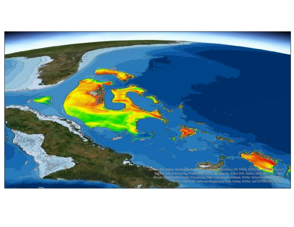
In total, TCarta produced nearly 150,000 square kilometers of 10-meter resolution SDB and over 1,000 square kilometers of WorldView 2-meter resolution SDB. Including up to 25 repeated measurements per 10-meter by 10-meter pixel, the project used imagery from 2020 to generate a gap-free SDB surface, creating the single largest piece of shallow-water bathymetry the company has produced to date.
4. SDB processing in the cloud
In late 2020, TCarta deployed Trident technology to the vast Red Sea coastal area. Integrating deep learning technology and cloud computing resources, the TCarta team further enhanced the scalability of the multitemporal composite technique. With automated assessment, the application analyzed every applicable image in the Sentinel-2 archive from 2017 forward—a total of more than 17,000 images—to create a massive multi-image, multitemporal composite of coastal waters in the region.
Additionally, TCarta’s deep learning model extracted an immense amount of ICESat-2 data, collecting more than 500,000 data points per single Sentinel-2 image tile. The data calibrated and validated the multi-image composites, producing roughly 45,000 square kilometers of 10-meter resolution SDB. With graphical processing unit (GPU) power, the deep learning model processes roughly 300 ICESat-2 ground tracks in a Sentinel tile far more quickly than a manual track-by- track review for just a handful of ground tracks.
Overall, the immense effort would have taken longer than a year employing previous methods and used only 1 percent of the imagery available in the Sentinel archive. Applying Trident tools and cloud computing resources for rapid data processing, TCarta completed the undertaking in a matter of weeks.
5. Urgent needs in the Meso American-Caribbean Sea region
Bolstered by AI and cloud technology, SDB has enormous potential for addressing the relative dearth of shallow-water bathymetry data worldwide and informing year-to-year hydrospatial analysis. Demonstrating the reach of the newly enhanced approach, TCarta’s recent deployments are easily repeatable across other broad geographic areas.
In the Meso American-Caribbean Sea region, the challenge is substantial – bathymetry data has only been amassed for roughly 20 percent of the Caribbean Sea—but the need is undeniable. As responses to Hurricanes Dorian and Isaias revealed, dynamic coastal areas urgently require accurate, up-to-date data for disaster preparedness and relief efforts.
Beyond its disaster response applications, SDB can play a critical role in hydrographic survey planning, hydrodynamical modeling and coastal zone management. And as sea levels continue to rise, continually updated shoreline bathymetry is vital in the region for tracking purposes.
In addition to gathering this actionable data, effectively disseminating it is crucial. Fortunately, advances in SDB technology are coalescing with largescale data-sharing initiatives in the region. The Caribbean GeoPortal—part of the larger Esri GeoPortal program—offers a community-built resource for gathering and disseminating timely geospatial data, and the MACHC-IOCARIBE Seabed 2030 Strategy focuses on amassing and sharing bathymetric data through partnerships with public and private organizations.
6. Evolving toward a global bathymetry model
Throughout Project Trident, SDB techniques and workflows have advanced rapidly. In 2018, state-of-the-art methodology involved incorporating one or two satellite images for SDB production, along with a few hundred points derived from stereo photogrammetry for validation. In 2019, validation capabilities expanded ten-fold with the development of ICESat-2 data extraction techniques. And in 2020, cloud technology and a deep-learning model increased SDB scalability by another order of magnitude.
In what appears to be a golden era for space-based hydrographic surveying, methods will continue to evolve and progress quickly. As the supply of Earth-observation satellites equipped with increasingly sophisticated sensors grows, SDB and data processing capabilities will expand exponentially. And debate and discussion about standardizing these technologies will continue.
The ability to iterate improvements and deploy SDB solutions at scale is at hand, within regions and around the world. As the era continues to unfold, TCarta looks forward to evolving Trident methods and platforms to meet its challenges—first and foremost, producing a global bathymetry model to have much-needed data in place before disasters strike.