
1. Introduction
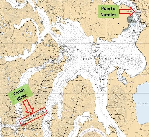
The Kirke Canal is located in the Magellan and Chilean Antarctic Region, specifically in the province of Ultima Esperanza. Its importance is that it constitutes one of the only two maritime accesses to the capital of that province, the city of Puerto Natales which, according to the 2017 census, has a total of 21,477 inhabitants. In addition, this city is a great tourist attraction, since it is a must stop on the way to Torres del Paine National Park, which has, according to the statistics included in its website (www.parquetorresdelpaine.cl), an average of about 500,000 visitors a year from all over the world.
2. The Kirke Channel characteristic
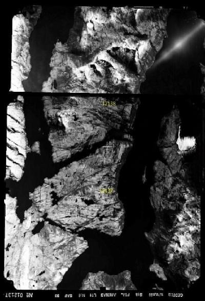
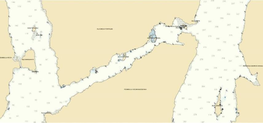
One of the characteristics of this area is its morphology, marked by the existence of several islands, channels, fjords and gulfs, which make it a particularly special area for navigation. Shoals, currents, tides, narrows, bad weather and other characteristics limits the types of vessels that can navigate the sector. In particular, the Kirke channel spans about 5 nautical miles, with a WSW-ENE orientation and an average width of 0.3 cables. At its ENE end stands out the Kirke Narrow, which allows access to the Valdés channel to continue sailing to Puerto Natales (Figure 1).
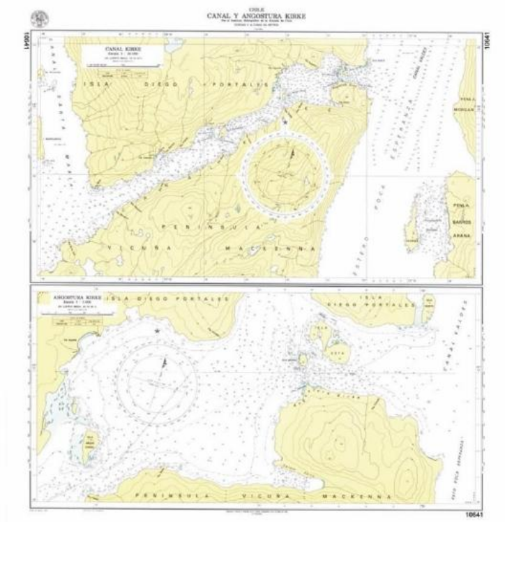
The Kirke narrow has in its narrowest part about 130 meters between coast and coast; but, in reality its navigable width is approximately 40 meters (Figure 2). The land extends from its south coast to the center of the canal, where a shallow feature of about 5 meters stands out. All of the above, according to the 8th edition of the SHOA Nautical Chart No. 10641 “Canal y Angostura Kirke”, which was published in 1982 and in force until October 2019, is referred to a Local Dátum that does not support the use of GPS systems; contains bathymetric data obtained from traditional single beam technology and has no equivalent edition of Electronic Navigational Charter (ENC).
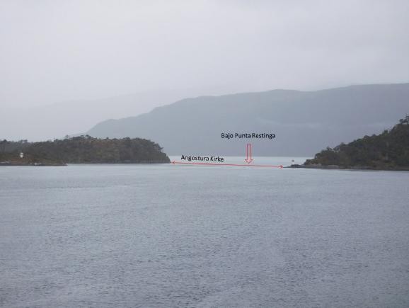
In addition to being narrow, the Kirke channel is a hydrographically complex area, where its bathymetric constrictions, coupled with continuous bad weather fronts, cause the tides and currents flowing through this passage to vary considerably in amplitude, intensity and direction in just over 200 linear meters, in the well- known Kirke narrow, where there is difficulty in the predictions of these phenomena.
In view of the complexity of this area, there was a need to conduct studies and analyses to ensure greater safety to navigation. This motivated various hydrographic campaigns to obtain bathymetry, geodesy, meteorology, tides and current data and seabed sediment samples, together with sailing experiences, etc These activities were executed in different years and by various professional groups of SHOA. In addition to this field work, studies were carried out based on information delivered by remote sensors, analysis of information and historical experiences.
3. Comparison between the new edition and its previous version
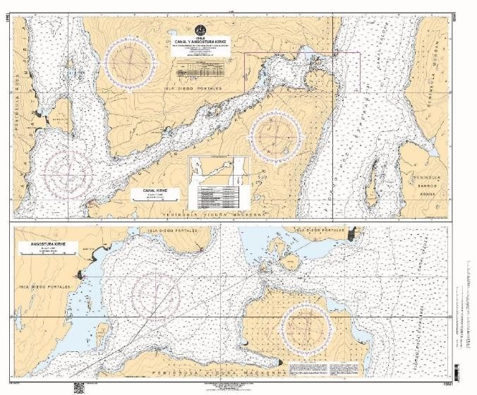
From all the sources collected over several years, a new edition of the SHOA Nautical Chart No. 10641 “Canal and Angostura Kirke” was published in 2019 (Figure 4), which has substantial improvements over the previous version, released 37 years ago. Some of the improvements presented in this new edition are detailed below:
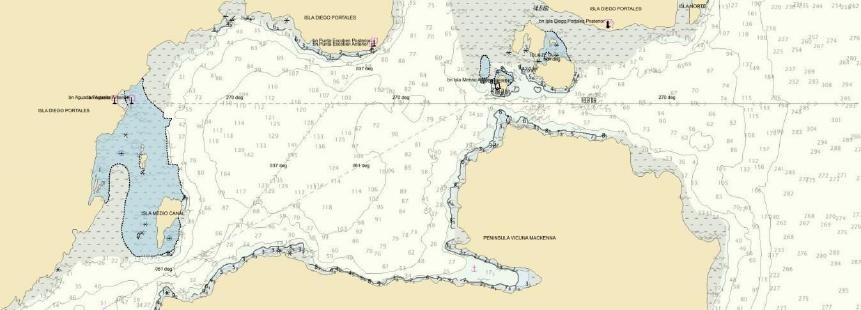
Boundaries: Geographic boundaries are different from the previous edition. This new chart scheme covers a larger area, which allowed inclusion of anchorages at each end of the chart (Fondeadero Storaker and Puerto Condell). These anchorages are of great help for navigation and serve as waiting points to cross the canal under the right conditions. Both were described in the Sailing Directions of the Chilean Coast, Volume III.
Scale: This Nautical Chart has a fairly special design, since it consists of two adjacent plans, but one corresponds to an extension of one sector contained in the other; which is usually represented by an inserted plan. However, given the geographical characteristics of the areas represented, it was considered that it would be best to maintain the previous design of adjacent plans, but implement an improvement in the scale of representation of both plans. The upper plan corresponds to the Kirke channel in its entirety, represented in the 1980s edition at a scale of 1:20.000, while the lower plan corresponds to the Kirke narrow, at a scale of 1:5.000. In this new edition, while the design was maintained, the limits were modified, as mentioned in the previous point, further improving the scale of representation of both plans, with the upper one at 1:15.000 and the lower at 1:4.000 scales, respectively.
Reference System: The previous edition was referred to a Local Datum, which meant that it w as not possible to use GPS, because its reference system was created especially for that chart, so it prevented the coordinates from being precisely brought to another system. The new edition has its horizontal reference in the SIRGAS WGS-84 Geodetic Datum, which has a geocentric origin, which makes it compatible with geodesic systems, allowing the use of GPS.
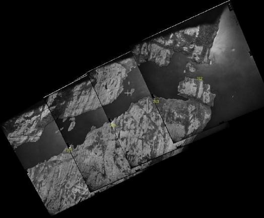
Base images used: The two editions have the same base and both processes used the same aerial photographs taken in 1970 by the Chilean Navy Hydrographic Institute (IHA), now SHOA, scales 1: 25.000 and 1: 15.000 (Figures 5 and 6). For a sector like this, temporal variation is not an issue, as it is an area of fjords, non-populated, where there are no considerable variations in the terrain on this time scale. There was no evidence of modifications by an event, whether of natural or anthropic origin from imagery and ground observations, nor according to historical record. Thus, the great difference between the two editions of the Charter has its origins in the geodetic support made for each process. For the 8th edition, the support was analogous, using a traverse, “Puerto Natales – Fairway Island” in local Datum; while for the 9th edition, the geodetic control made in 2017 was digital which allowed the photographs to be returned directly to the WGS-84 Datum. With regard to accuracy, the previous edition estimated an average error close to 5.5 m and an uncertainty of 1.8 m; while, in the case of the last edition, the average error is 0.7 m and an uncertainty of 0.9 m; that is, it has sub metric precision. Since the base images are the same for both editions, the difference occurs because in the field work1, the new geodesic measurements allowed to make an adjustment that, given the precisions of the measurements and computational tools, achieve those standards of accuracy.
scale 1:25.000.
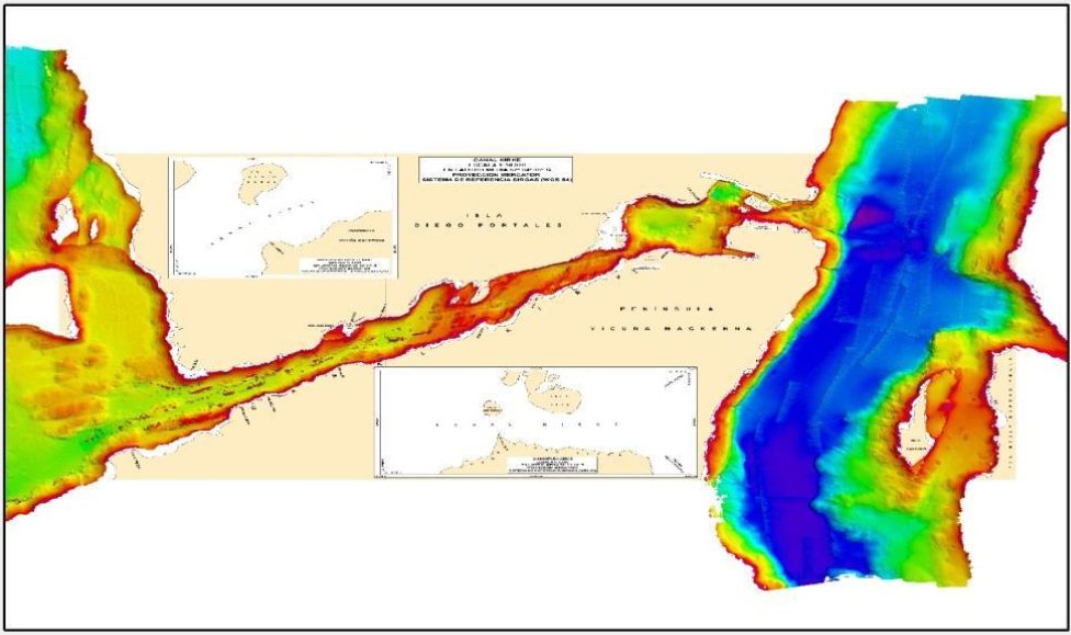
Bathymetric Density: The 1982 edition was based on bathymetry obtained with single beam techno-logy. This is discrete information, with uncertainty of the depths and values between one depth and another. The 2019 edition used bathymetric information from two hydrographic surveys conducted in 2014 and 2017, both conducted by the hydrographic survey vessel PSH Cabrales. The bathymetric data on the current edition comes from the Kongsberg EM710 and EM3002D multibeam echosounders (MBES), in addition to Reson’s Seabat 7125 MBES. This bathymetric survey effort resulted in 98% coverage of the seabed (Figure 7). These data identify all features that might constitute a danger, whether of natural or anthropic origin, allowing the navigator to choose the best route to navigate in this area. The installed sonars delivered values throughout the channel, achieving information from the Kirke narrow, practically coast to coast, and identifying with absolute precision both the location and the minimum depth of the bottom as well as all the other features of the seabed contained within the limits of the new edition of the Nautical Chart.
Accuracy of bathymetric information: As mentioned in the previous points, the depth data from the 1982 edition comes from single beam echosounders, with a non-geodetic reference system. This sparse information is not compatible with current technology and contains uncertainties that cannot be quantified with current methods and standards. The new edition, given its origin, has real-time geodetic positions with corrections from geostationary satellites and the data has known uncertainty values. These values were calculated after processing the survey data within the CARIS HIPS & SIPS software. Thus, the fact that we now know the uncertainty is already considered an improvement.
After the processing was completed, based on IHO standard S-57 and with regard to Category Zone of Confidence (CATZOC), this survey complies with Order A2, which ensures vertical uncertainty of 1.0 m +2% of depth. In practice this means, for example, that, at a depth of 10 m, vertical uncertainty will correspond to a maximum of ± 1.2 m, while at 50 m it will be ± 2.0 m. Again this results in substantial improvement of the product delivered to the user.
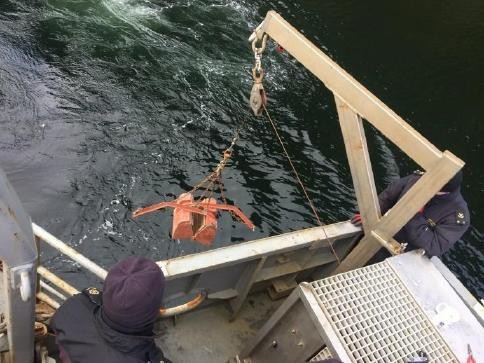
Seabed information: The 1982 edition did not have seabed classification information, so for the new edition it was considered, which was obtained by a dredger in all places indicated as recommended anchorages (Figure 8 and 9). From the samples obtained, an analysis was performed using a sieve, which allowed separation of the different sediment fractions present, which were classified according to the Wentworth particle size scale (1922).
during the Hydrographic Survey in 2017.

during the Hydrographic Survey in 2017
Electronic Nautical Chart: Due to the year of publication, the 8th edition does not have an electronic version; while, from the data used in the 9th edition, the first edition of the Electronic Navigational Chart (ENC) (Figure 10 and 11) was drawn up. The ENC, having the same source data and being prepared from the same database, offers absolute consistency with the Nautical Paper Chart, both products being equivalent, despite not being equal for mainly representational purposes.
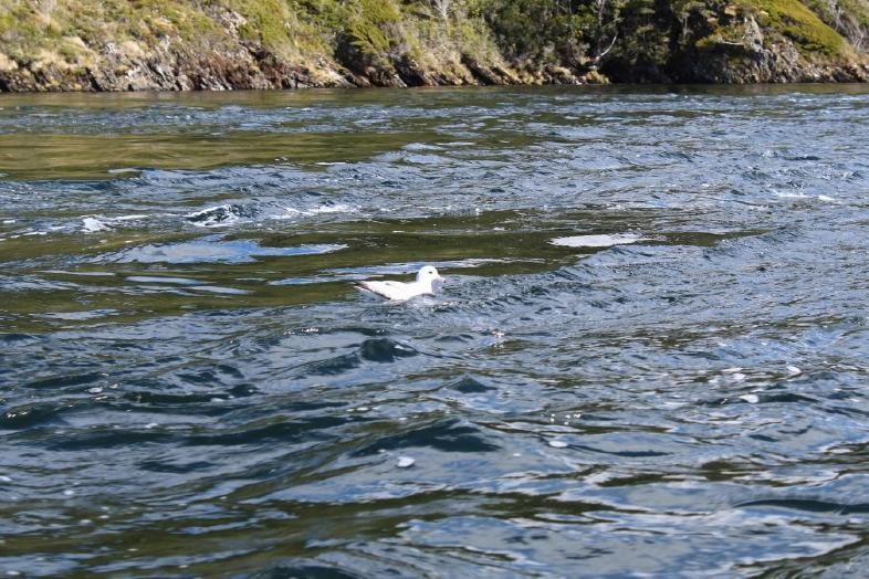
Sailing Experiences: SHOA Publication 3003 ” Sailing Direction s of the Costa de Chile, Volume III” , until before the surveys conducted since 2014, described the navigation of the Kirke channel based on the information available in the 8th edition of the Nautical Chart, in addition to some gathered experiences. This description was rather qualitative, noting, for example, that for the crossing of the Kirke narrow “it was necessary to observe whether there were birds perched in the water” (Figure 12), since this indicated that the intensity of the current would not be significant. This showed to be not entirely true as observed during the surveys. Acquired information allowed corrections and new recommendations; most of them quantitatively, based on the measurements made, providing greater objectivity to the information provided.
during the Hydrographic Survey in 2017.
Tides and currents: The general description of these phenomena began in the early tw entieth century, allowing inclusion of the first current data in cartography and the first descriptions in the Nautical Publications. Subsequently, in order to predict currents in the channel, the methodology called secondary port correction was used. In the case of Kirke, this methodology only achieved a good adjustment in the prediction of the still water before starting to raise the level to the high tide, using the hours of occurrence of the high tide in Puerto Montt, plus a delay due to the lunar phase. Thus, with this method, vessels had for more than 20 years only one opportunity to cross the narrow, when the still water occurred during daylight. This information was provided in the 1982 edition of the Nautical Chart and in the yearly produced “Tide Tables of the Coast of Chile” (SHOA Publication No. 3009).
Different studies have been carried out to improve the information available, highlighted in the year 2001, when through the use of acoustic current meters (ACM) and tide gauges, the tides and currents in the channel were measured again, this time at the entrance and exit of the narrows. This allowed delivery of a prediction of the time of the still water, more in line with what was experienced in it. Subsequently in 2014, by installing 5 tide gauges, 1 current meter and a weather station, the tides and currents in the channel and narrow were measured for 54 days, resulting in a definition of 22 zones for the determination of the sounding reduction level, as a result of variations in range and phase of the tide. In terms of current, predictions of the still water hours and time and intensity of the maximum current at an observation point were made. In 2017, a new survey was conducted in the sector, installing a current meter in the narrow, which prior to the finalization of its deployment the anchoring system was cut off (like so many other times in the past), without obtaining useful measurements. 12 tide gauges were installed along the channel, which allowed the reduction of the soundings as well as improving tidal forecasts for the sector. In addition, in 2019, a horizontal acoustic doppler current meter (HADCP) was installed, which stores the current registers internally and also emits in real time the direction and intensity of the current to the vessels, precisely in the area where the greatest currents are observed in the narrow. This information allows for a longer record, making harmonic analysis more reliable to predict currents and thus be able to program a safe passage through the narrow.
Thus, beginning with anecdotal information from the early twentieth century in Cartography and Publications, tide and current information was improved with data obtained by more than 15 sensors installed in the last 5 years, as well as real-time information for users, thanks to a weather station and a current meter permanently installed at the southern tip of Merino Island. this station transmits temperature, true wind and current direction and intensity information, through VHF channel 10, with a range of up to 10 nautical miles.
Finally, in order to ensure that all new information compiled in these new products, both paper charts and ENC, tidal and current forecasts and the description included in the Sailing Directions were reliable, a navigation test was carried out aboard the OPV 83 “Marinero Fuentealba”. Evaluation by various authorities, together with the ship´s crew, confirmed the quality of these new tools that facilitate the navigation of this channel and its narrows.
4. Conclusions
This new edition of SHOA Chart No. 10641 “Canal y Angostura Kirke” is the product of a considerable evolution in terms of the technology used for its creation, from planning, field data collection, processing, cataloguing and validation in the database, to the final publication of the new cartographic edition; with the consequent updates and improvements of the Sailing Directions and other publications.
This process shows the progress that has been made over the years, effort that has not been in vain, improving processes, transferring knowledge to the next generation of professionals, who work hard in different areas and with very diverse skills; all in a productive line, whose main objective is to provide Safety to Navigation. Today, boats sailing in either direction in the Kirke Canal do so more safely, with more information and better quality; as well as with various tools that allow them to make better decisions, greatly increasing the likelihood of success and reducing the risk of accidents in one of the most difficult channels to navigate in Chilean waters.
5. References
- International Hydrographic Bureau (March, 2002). Special Publication S-57, “IHO Transfer Standard for Digital Hydrographic Data”, Monaco.
- Chilean Navy Hydrographic and Oceanographic Service (2015). Pub. SHOA No. 3000 Catalogue of Nautical Charts and Publications, Valparaiso, Chile.
- Chilean Navy Hydrographic and Oceanographic Service (November, 2019). Publication SHOA No. 3500 Notice to Mariners, Valparaiso, Chile.
- Sifón, M. (2014). Characterization of the Tide and Calculation of the Sounding Reduction of the Kirke Canal (Thesis Work), Chilean Navy Hydrographic and Oceanographic Service.
- Sifón, M. (2017). Commission Report Ord. No. 10640/10641- – 142017 “Canal and Angostura Kirke Hydrographic Commission”, Chilean Navy Hydrographic and Oceanographic Service.
- Report made by OPV 83 “Marinero Fuentealba” in October 2019, as part of the new product test conducted in the area.
________________________________________________________________
- Geodesic measurements were made during the 2017 field work, which used dual-frequency differential GPS equipment, measuring 7 support points for the images used. In addition, for the aero triangulation process, carried out in 2018, an Erdas photogrammetric station was used, with the Erdas Imagine Photogrammetry and Orima software.