
Abstract
The ocean covers almost 70 % of our planet. It is responsible for approximately 50 % of the oxygen we breathe, makes all life on our planet possible, and is also responsible for making the Earth look blue when viewed from space. The ocean plays a fundamental role in regulating the climate. It produces most of the water vapour, which condenses and creates clouds, which is then released as precipitation.
Better knowledge of the ocean is essential to understanding the various threats facing society, including: climate change, sea level rise, global warming, tsunamis, and earthquakes. Deep ocean seafloor observation could improve tsunami monitoring and climate change causes and effects, like sea level rise. For example, a better understanding of deep ocean circulation and sea level rise could improve the complexity and accuracy of models of ocean-atmosphere interaction which contribute to our understanding of global climate.
Despite the potential benefits, the deep ocean floor remains poorly observed and monitored. Given the size of the ocean, its exploration is difficult and expensive. For example, to detect and monitor tsunamis, the most commonly deployed method is the use of Deep-ocean Assessment and Reporting of Tsunami (DART) buoys to measure pressure; however, the buoys are mostly placed near the coasts of the countries that control them due to high operating costs.
The Global Ocean Observing System (GOOS) has defined temperature and pressure as two of the Essential Ocean Variables (EOV’s) to effectively provide oceanographic forecasts and early warning, climate projections and assessments. These variables are currently being monitored mainly in situ, by boats, buoys, anchoring systems or floats, and by remote sensing, such as the various existing satellite techniques for both information acquisition and processing.
Submarine cables are critical to the provision of commercial internet, and are the main means of data transmission globally (Fig. 1). There are more than 1 million km of operational submarine telecommunications cables (Howe et al., 2022), though the number of existing cables and their distribution is not even. There exists a clear difference between the northern and southern hemispheres, leaving an important area without cable coverage in the South Pacific.

The Science Monitoring and Reliable Telecommunications (SMART) Cables initiative (SMART Cables, 2024) could improve the rate of acquisition of seabed data (i.e. pressure, temperature and acceleration mainly) by integrating sensors that measure various ocean variables using the infrastructure of submarine telecommunications cables. These cables could potentially be the most extensive and cost-effective system for achieving such measurements (Howe et al., 2022). The Humboldt transoceanic cable project that would connect Sydney, Australia with Valparaiso, Chile seeks to improve coverage of telecommunications cables in this region and presents an opportunity to deploy SMART cables as well.
The idea of taking advantage of the efforts of the submarine telecommunications cable industry to measure essential ocean variables is a promising solution to obtain information from large areas in real time, while having a minimal impact on both the environment and the telecommunications industry. Since the telecommunications cable will be deployed, the infrastructure needed to install the sensors and transmit the data is already in place, leaving as the principal challenges the achievement of minimal environmental impact and the engineering of the sensors to ensure maintenance-free operation for the lifespan of the cable. This configuration would lead to economic savings due to the high cost of deploying both systems independently.
By using the infrastructure of submarine cables, it is possible to monitor hard-to-reach places very efficiently, especially considering that there are already dedicated submarine cables for scientific research, so their integration with telecommunications cables should not be complex. The ideal result would be for the cables represented by lines in Fig. 1 to have SMART repeaters every 70 km, which would allow for a virtually global monitoring network of the ocean floor. Obviously, the separation between each SMART repeater can vary depending on the reality of each project, also considering the challenge of processing the information acquired through these systems.
Sensors would be installed on SMART repeaters, defined by Howe et al. (2019), that can theoretically measure as many variables as desired; however, for this exercise, temperature and pressure sensors have been chosen, in conjunction with accelerometers (a possible configuration of SMART repeaters and their sensors is shown in Fig. 2). It should be noted that, due to the nature of the parameters to be measured, both the pressure and temperature sensors must be in direct contact with the environment, while the accelerometer can be inside the housing.

In this design, the data generated by the sensors is transmitted through the same telecommunications network and uses the network’s infrastructure for power supply. Installation and maintenance efforts being matched with those of cables and the potential for rich data collection already represent significant advantages, but there are also other benefits to consider. Since the sensors are on the seabed, the possibility of vandalism of the instruments is drastically reduced, mitigating one of the problems that maintainers of other observing systems such as buoys or ground stations must deal with, as well as intermittency in transmissions, whether these are due to power supply problems or the transmission method itself (satellite, cellular network, etc.).
Inaccessibility also poses a challenge in terms of engineering since sensors must be able to function maintenance-free for the lifespan of the cables, which is around 25 years. Currently, most oceanographic sensors operate with regular maintenance, so the design of both the SMART sensors (pressure, temperature and accelerometers) and the repeaters must be durable. Among other issues, the best way to deal with biofouling and also to prevent interference with the adjoining telecommunications systems is still a matter of study.
Overcoming the challenges to develop a robust seafloor monitoring network is important because these networks of sensors can greatly improve our understanding of climate. For example, deep Antarctic waters are known to be warming due to the constant absorption of heat, contributing to sea level rise. In addition, the South Atlantic circulation is changing, which is associated with variations in ocean temperature, heat flux at the ocean-atmosphere interface, and sea level, suggesting that deep circulation is a relevant element in the global climate. Thus, the temperature sensors of the SMART cables would provide data with a greater spatial and temporal density in the deep ocean and in real time than current techniques allow, with which we could better understand these phenomena, helping to understand their implications for the planet and the society.
Variations in sea level can impact coastal communities and various marine species. Even in terms of international policy, sea level rise could affect the boundaries established between countries and some islands countries could see the surface of their territory reduced considerably. Global warming has caused sea level rise to occur on average at rates of 3.0 ± 0.4 mm/year since 1992, with an estimated acceleration of 0.084 ± 0.025 mm/year2, implying that, if these values were maintained, sea level would have risen by 65 cm by the year 2100 (Howe et al., 2022), However, this change is not homogeneous mainly due to the effects of changes in mass resulting from the melting of ice, expansion of water due to warming, changes in ocean volume, changes in land heights, etc., so measurement techniques with broad spatial coverage and sensors that measure pressure and temperature are required to contribute to the study of the particular contributions in each place.
Wind waves, with periods of less than 30 s, play a crucial role in the exchange of heat and gases between the ocean and the atmosphere and can be a threat to coastal areas. Due to their wavelength, which in deep waters are always much smaller than depth, they cannot be measured from the seabed at more than 1000 m, so satellites and floating buoys are used. However, the need for the observation of these waves in the vicinity of the coast and in real time is increasing, so the SMART sensors on the continental shelf and areas near the coast constitute a valuable alternative that could provide information on wave amplitude, period and even direction (Howe et al., 2019).
Another relevant point is the monitoring of tsunamis, oceanographic waves with periods considerably longer than the wind waves described in the previous paragraph, which is done by measuring pressure variations from the seabed mainly using DART technology developed by NOAA. The DART technology allows for discrete measurement in real time, with high support and maintenance costs, requiring installations to be close to the coast. The information is transmitted by means of satellite systems through a buoy, while the sensor installed on the seabed has electrical power systems through batteries, which require frequent renewal. To avoid unnecessary use of the batteries, consumption is reduced through few transmissions per day, which increase their frequency if activated as a result of the occurrence of an earthquake or tsunami. Despite its limitations, the DART system is currently considered one of the best alternatives for real-time tsunami monitoring in the deep ocean, which allows the generation of tsunami propagation models for both early warning and scientific research. To maintain its concept of operability for tsunami hazard risk management, however, monitoring frequency must be sacrificed.
Tsunami observation in open waters through direct data is important because their geophysical characteristics give these waves the ability to cross the ocean and affect coasts that are thousands of kilometres from their place of origin, causing great damage. Timely alerting of coastal communities is therefore essential. However, it is important to be able to determine whether a tsunami will truly affect a particular community, preventing an unnecessary evacuation, which comes at a high cost (economic, credibility, community effort, possible accidents during the evacuation process, etc.).
Computational modelling is used by early warning systems to estimate the generation and propagation of tsunamis generated by subduction mega earthquakes (Maule, 2010; Tohoku-Oki, 2011; Valdivia, 1960). These models allow us to estimate effectively the possible impact of this type of tsunami, which can take several hours to reach distant coasts. Robust monitoring of the propagation of a tsunami in deep waters allows for the corroboration of computational models.
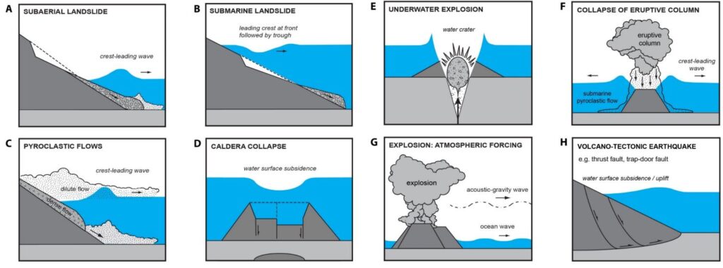
For tsunamis generated by sources other than subduction mega earthquakes, like the tsunami resulting from the eruption of the Hunga-Tonga Hunga-Ha’apai volcano in January 2022, there are no computer models that are able to estimate the tsunami threat to carry out a timely evacuation. This is mainly due to the complexity of the source of tsunami generation (Fig. 3), which for this case and many others, cannot be determined in useful times for early warning, so monitoring the spread of the tsunami is essential to alert coastal communities. Although DART buoys are an excellent tool, as they are installed close to the coast, they are not enough, and there are blind areas, such as in the South Pacific Ocean (Fig. 4).

This online monitoring system is maintained by the U.S. National Buoy Data Center (NDBC).
In the case of seismicity, as with the other variables, there are also blind spots to cover. The cost of installing underwater seismological instrumentation is very high, so most of the instruments are on land, which complicates analyses. Currently in Chile, for example, seismic monitoring is practical only in a north-south direction, due to the geomorphology and orientation of the territory, complicating the determination of some earthquake parameters. In the South Pacific, there are few sensors toward the centre of the ocean. If accelerometers were to be installed on submarine cables, the study of seismicity would be enhanced both in science and in early warning systems, as well as for engineering studies, directly benefiting mainly coastal communities.
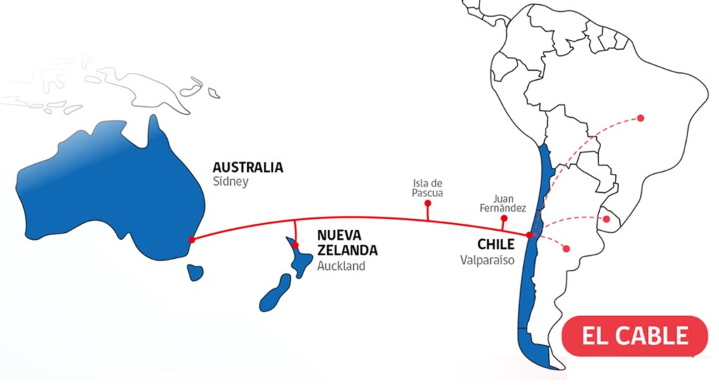
One way to improve the seismological network would be via the implementation of SMART Cables with accelerometer sensors, although, at present, there is no submarine cable that crosses the South Pacific Ocean. However, the Humboldt telecommunications project mentioned above, which aims to link Australia, New Zealand and Chile by means of fibre optic cables (Fig. 5), not only covers that blind space, but also crosses four major tectonic plates, which would allow for a very powerful study of seismicity and provide a direct contribution to the early warning of earthquakes and tsunamis.
While there are many benefits to be gained from SMART technology, the Joint Task Force (JTF) has decided to use it primarily to address two issues: (1) the permanent acquisition of data to evaluate phenomena associated with climate change and (2) to contribute to the sea level monitoring network to enhance tsunami early warning systems, through temperature and pressure sensors, in conjunction with accelerometers. JTF SMART Cables is an initiative led primarily by three United Nations agencies: the International Telecommunication Union (ITU), the World Meteorological Organization (WMO) and the Intergovernmental Oceanographic Commission (IOC/ UNESCO).
Currently, there are different projects that are in the process of analysis with SMART cables, the most notable being the one that will link New Caledonia with Vanuatu and the one in Portugal, which will link Lisbon, Madeira and Azores. These two projects have funding for the implementation of this technology and are expected to be the first to come into operation. The first of these will have an extension of about 300 km, with between two and four SMART repeaters, while the second will be 3,700 km, with 50 repeaters. Other projects that are expected in the future to include SMART repeaters are the aforementioned Humboldt project, as well as the one that will link New Zealand with Antarctica and Australia with Antarctica.
The implementation of SMART technology would substantially improve our understanding of the ocean and some geophysical processes such as ocean temperature, ocean circulation, sea level rises, tides, currents, tsunami and seismic, enhancing engineering, early warning systems, climate change mitigation measures and more.
In this way, SMART Cables combines two key concepts in today’s society: the increase in pressure to achieve greater global connectivity and the urgent need to coherently address climate change and ocean management, achieving a synergy widely discussed today under the concepts of Blue Economy and Ocean Discovery, as well as by the United Nations Sustainable Development Goals. The telecommunications industry will continue to install submarine cables, so the question is, what if we take advantage of that infrastructure to do science for the direct benefit of the planet and society? How would it improve our understanding of the planet?
References
Bischof, Z. S., Fontugne, R. and Bustamante, F. E. (2018). Untangling the world-wide mesh of undersea cables. Proceedings of the 17th ACM Workshop on Hot Topics in Networks (HotNets ’18), Association for Computing Machinery, New York, NY, USA, pp. 78–84. https://doi.org/10.1145/3286062.3286074
Howe, B. M., Arbic, B. K., Aucan, J., Barnes, C.R., Bayliff, N., Becker, N., Butler, R., Doyle, L., Elipot, S., Johnson, G. C., Landerer, F., Lentz, S., Luther, D. S., Müller, M., Mariano, J., Panayotou, K., Rowe, C., Ota, H., Song, Y. T., Thomas, M., Thomas, P. N., Thompson, P., Tilmann, F., Weber, T. and Weinstein, S. (2019). SMART Cables for Observing the Global Ocean: Science and Implementation. Front. Mar. Sci., 6:424. https://doi.org/10.3389/fmars.2019.00424
Howe, B. M., Angove, M., Aucan, J., Barnes, C. R., Barros, J. S., Bayliff, N., Becker, N. C., Carrilho, F., Fouch, M. J., Fry, B., Jamelot, A., Janiszewski, H., Kong, L. S. L., Lentz, S., Luther, D. S., Marinaro, G., Matias, L. M., Rowe, C. A., Sakya, A. E., Salaree, A., Thiele, T., Tilmann, F. J., von Hillebrandt-Andrade, C., Wallace, L., Weinstein, S. and Wilcock, W. (2022). SMART Subsea Cables for Observing the Earth and Ocean,
Mitigating Environmental Hazards, and Supporting the Blue Economy. Front. Earth Sci., 9:775544. https://doi.org/10.3389/feart.2021.775544
Schindelé, F. (2023). Tsunami Generated by Volcanoes (TGV), IOC Report (Feb 2023). 8th Joint ICG/PTWS – IUGG JTC Technical Workshop, 11th September 2023, Nuku’alofa, Tonga. https://oceanexpert.org/downloadFile/54669 (accessed 18 February 2024).
SMART Cables (2024). SMART Systems – Launched, SMART Cables. https://www.smartcables.org/ (accessed 31 March 2024).
- https://www.ndbc.noaa.gov/ (accessed 3 October 2023).
- https://www.subtel.gob.cl/cable-humboldt/ (accessed 1 October 2023).