


Abstract
1 Introduction
The foundational part of the hydrospatial sciences (Hains et al., 2022) is the science of hydrography, which is defined as the branch of applied sciences which deals with the measurement and description of the physical features of oceans, seas, coastal areas, lakes and rivers, as well as with the prediction of their change over time, for the primary purpose of safety of navigation and in support of all other marine activities, including economic development, security and defence, scientific research, and environmental protection1. More than 70 % of our planet is covered by water; we call it – “all the Blue of our Blue Planet and its contiguous zones“ (Hains et al., 2022). According to The Nippon Foundation – GEBCO (GEneral Bathymetric Charts of the Oceans2), Seabed 2030 Project3, as of June 2023 only 24.9 % of the oceans have been mapped to adequate modern measurement techniques and standards. “Detailed knowledge of the shape of the seafloor is crucial to humankind. Bathymetry data is critical for safety of navigation and is used for many other applications” (Wölfl et al., 2019). The increase from 6 % in 2016 to 24.9 % in 2023 in data and knowledge since the inception of The Nippon Foundation – GEBCO Seabed 2030 Project is great progress.
However, at this rate, if the future progress is not better than linear, with the traditional means of measuring the bathymetry of our waters by specialized ship-based platforms, the best we could anticipate achieving would be about 50 % of coverage by 2030. While this would still be a positive achievement, it would fall short by about a half of the target for 2030. So how can we possibly meet this exciting challenge and great opportunity of measuring and mapping our waters by 2030? Citizen Hydrospatial Sciences, Crowdsourced Bathymetry (CSB) and the increased use of new technologies, such as remotely operated underwater, surface and airborne hydrospatial survey vehicles, often called the rise of robotic systems, stand to be an essential part of the solution to fill this gap. Citizen Sciences have proven to be critical in the fields of Ecology and Biodiversity monitoring (e.g., birdwatching and behaviours); as well as in Environmental Monitoring, such as pollution tracking of water and air; Public Health and epidemiology; and Conservation and Habitat restoration.
2 Citizen hydrospatial sciences
With the impacts of climate change becoming more apparent, private citizens are increasingly interested in contributing to solutions by observing, questioning, studying, designing, collecting, analyzing data and communicating their perspectives to applicable stakeholders. (Fig. 1).

Now that the Citizen Science is clarified, we can define the hydrospatial terms associated with Citizen Science in the title of this note, a definition which comes from the Hydrospatial Movement Club and Community’s adopted definitions:
- hydrospatial – adjective
Relating to hydrospatial sciences or denoting data, information and knowledge that is associated with a particular location and time of the earth’s waters and their contiguous zones.
- hydrospatial sciences – plural-only noun (plurale tantum)
All sciences dealing with the study of the earth’s waters and their contiguous zones.
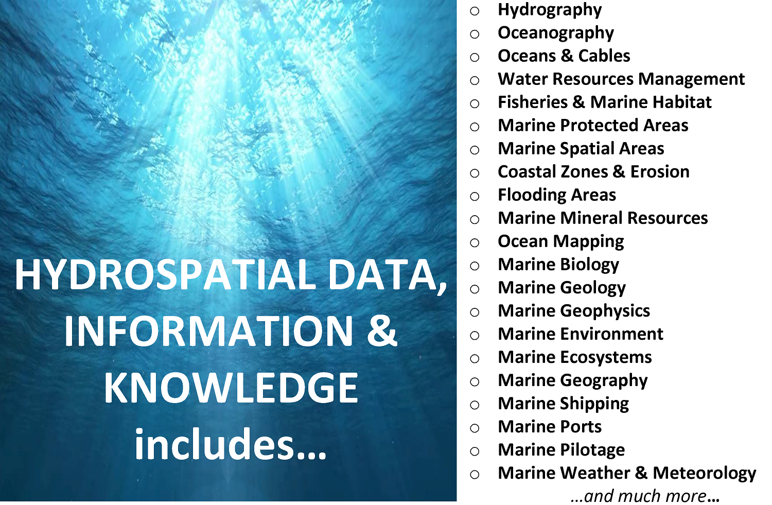
The hydrospatial sciences are numerous (Fig. 2). Given the size and the scope of all the hydrospatial sciences, it is unrealistic to consider that traditional measurements with current technologies and limited ship-based approaches will suffice to cover the requirement for data, information and associated knowledge. Like previously perceived unsurmountable challenges, a step-by-step and collaborative approach is needed to achieve the objectives of the United Nations (UN) Decade for Ocean Science & Sustainability as well as Seabed 2030. With limited resources, all Governmental and Non-Governmental Organizations may benefit from willing non-expert unpartisan science groups. This voluntary, citizen help should not be rejected; rather, it should be encouraged and be framed within logical constraints and standards. Citizen Science must be embraced and categorized accordingly to understand the relative value of different data sets and the reliability of the information integrated into common databases.
3 Is crowdsourced bathymetry the same as citizen hydrospatial sciences?
The set of Citizen Hydrospatial Sciences is much broader than CSB. CSB is however a subset of bathymetry, an important contributor to it, and an essential layer for most of the hydrospatial sciences. CSB is defined by the IHO in its publication B-12 as (IHO, 2022):
“[…] the collection and sharing of depth measurements from vessels, using standard navigation instruments, while engaged in routine maritime operations.”
From that definition, we can see that the emphasis is on “[…] depth measurements […]”, and therefore the logical nexus to bathymetry. The definition also specifies that CSB is “[…] from vessels, […]”, so meaning boats and ships using their “[…] standard navigation instruments, […]”, a set which includes echosounders and positioning systems. The quality of today’s positioning systems and echosounders is continually improving; accordingly, these can offer valuable data for a better knowledge and understanding of bathymetry, particularly in areas with very old, sparse or no existing bathymetric data. The last part of the CSB definition demonstrates that CSB results from vessels “[…] while engaged in routine maritime operations (RMO)” reflecting that the main purpose of the RMO are not systematic surveying (neither hydrographic surveying nor Marine Scientific Research (MSR)) but rather operations such as a passage from one place to another, conducting fishing operations, or eco-tourism. The beauty of CSB is that RMO can produce the collateral benefit of contributing to a bigger cause, i.e., the exponential increase in reported soundings over geolocations that lack sounding data, as well as providing repeat soundings over heavily trafficked channels. The latter may provide change detection, revealing the following: undefined features, newly detected wrecks; and hazardous maritime debris (Sedaghat et al., 2013; Payne, 2013). The benefits contribute to mobile seabed monitoring, increased data availability, cost-effectiveness, timeliness, community engagement, risk mitigation, support for scientific research, complimentary methods, and encouragement to innovation.
4 “To csB or not to csB – that is the question…”
Just as William Shakespeare’s Hamlet is famous for stating the philosophical question “To be, or not to be, […]” (Act 3, Scene. 1), the global maritime community faces an equally important philosophical question of To csB or Not to csB…to Map the Sea and waters. The idea of leveraging a crowd of stakeholders to collect bathymetric data is not a new phenomenon (IHO, 2020a) – in fact, a GEBCO established Working Group in 1995 made a recommendation that “[…] attempts should be made to get funds from agencies such as the [United States] Defense Mapping Agency to fund echo-sounding on commercial transits” (Carpine-Lancre et al., 2003, p. 127). The former Defense Mapping Agency (now called The National Geospatial-Intelligence Agency) has the legislated mission to “improve the means of safe navigation […] which includes the production and dissemination of nautical charts” (United States Code, 2024). The pressing question today, however, is how this data may be used by the global community of stakeholders, including HOs; how to use CSB was the rationale for the creation of the IHO’s Crowdsourced Bathymetry Initiative, which resulted in the creation of the IHO’s Crowdsourced Bathymetry Working Group (CSBWG; IHO 2020a).
According to its Terms of Reference, the CSBWG is composed of “…representatives of IHO Member States (MS), invited expert contributors, including members of IHO-IOC (Intergovernmental Oceanographic Commission) Technical Sub Committee on Ocean mapping (TSCOM), and observers from accredited NGIOs (National Geospatial Information Organizations) and the secretarial role of this WG is played by a representative of the IHO Secretariat” (IHO, 2021).
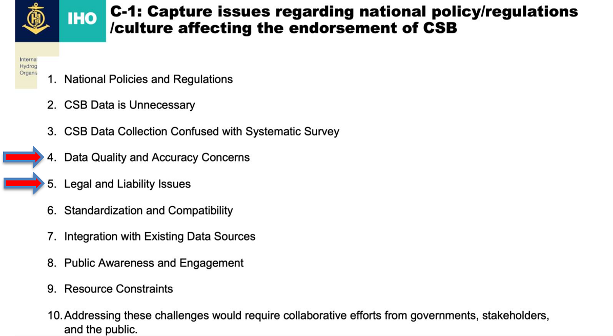
As of the end of 2023, approximately only a third of the MS of the IHO had responded to the International Hydrographic Organization (IHO) Circular Letters (CLs), namely Annex B to IHO CL 11/2019 (IHO, 2019) and to the questionnaire in Enclosure to IHO CL 21/2020 (IHO, 2020b). These IHO-CLs stipulate the support to CSB activities in waters of national jurisdiction as a means to contribute to the IHO Data Centre for Digital Bathymetry (DCDB) for archive and public distribution. From the unofficial communication with MS who have responded unsupportive or with restrictions and also with MS who have not yet responded to the CL, the IHO CSBWG has interpreted and extrapolated some reasons for the hesitance of these HOs to support the free and open sharing of CSB. The list of ten points in Fig. 3 is a starting point, only an assessment that requires further work. While the authors of this note respect all MS and HO perspectives for not yet endorsing the CSB activities at this time, we do offer counterarguments to some or most of the ten items listed below. In this note, the authors will focus only on the item 4 – Data Quality and Accuracy Concerns; and, item 5 – Legal and Liability Issues.
5 Whatever the data source is… “A shoal is a shoal!”
It might be useful to first define the terms precision, accuracy, quality, uncertainty and ambiguity (Heiskanen & Moritz, 1967):
- Precision refers to the degree of exactness or re producibility of measurements. High precision im plies that repeated measurements yield very similar while not necessarily aligned with the true value.
- Accuracy refers to how close a measured value is to the true or accepted value. High accuracy implies that measured values are close to the true values.
- Quality refers to the reliability, accuracy, and consistency of measurements.
- Uncertainty refers to the lack of exact knowledge about the true value due to various sources of errors.
- Ambiguity arises when there are multiple possible interpretations or solutions to a problem leading to the uncertainty about the correct solution.
Data quality and accuracy are often associated with precision and uncertainty (Fig. 4). The authors argue that regardless of the ambiguity or uncertainty in the data, shallower depths detected in potentially less precise CSB datasets are likely to also be identified in higher precision datasets. This means that all shallower depths and other information provided via CSB should not be disregarded; they could serve as indicators of potential hazards to navigation. The authors suggest that the primary focus, or fundamental purpose of a Hydrographic Office (HO) should be ensuring the safety of navigation by using the best available data. Given the constraints of limited resources and the varying priorities of different HOs, the best data may not always come from the most accurate or precise sources and may sometimes originate from outside the HO itself. Therefore, the use of data from various sources (including CSB) could improve the safety of navigation.
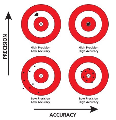
As shown in Figure 4, the aim shall always be to have the highest accuracy and most precise data possible. However, when nothing else is available, and if the data is very old, the lower accuracy and lower precision data might well be the best data available. It is not recommended to discard any data. But it is essential to educate users of the variable uncertainty or ambiguity of data provided. The authors of this note do not agree the premise that an HO is potentially encouraging a mariner to unsafely navigate poorly surveyed waters by using CSB soundings when no other soundings exist. Datasets can and should be categorized and illustrated accordingly, ideally quantified or if necessary rated for its quality. With level of confidence of the datasets published, mariners/navigators can and should assess risk management themselves, the reliability with respect to their own needs, and then mitigate the relative risks. Using CSB soundings on nautical products may further lower the risks for users who would decide to navigate the areas anyway, according to their local knowledge. Ensuring data quality is and will remain a big challenge, but the authors argue that not sharing CSB data is suboptimal, as it removes potentially relevant information from the set of data inputs a navigator needs to make shipboard decisions for safe navigation. Fundamentally, ultimate responsibility for safe navigation rests with the ship and its navigator. For example, in the Norwegian appellate case following the 2004 grounding of the M/V Rocknes in the Vatlestraumen passage near Bergen, Norway, the Court of Appeal is reported to have stated “responsibility for safe navigation always lies with the ship’s captain and navigator, and not with the mapping agency that provides quality-assured nautical charts” (Hydro International, 2011; IMORules, 2024). In the alternative, even if CSB data is not used by the navigator, the IHO recognizes that “While CSB data may not meet the accuracy requirement for charting (Nautical charts) areas of critical under-keel clearance, it holds limitless potential for myriad other uses.” (IHO, 2022).
Even in cases where highly accurate and precise data exist, depending on the age of this data, the siltation rate of the site or other local regime, it is always possible that debris or hazards could have appeared on the seabed since the last highly accurate survey took place. In that circumstance, a more recent CSB data set might detect a hazard to navigation that might have appeared since, and then bring up the requirement for a temporary navigational warning, or a Notice to Mariner requirement until a new highly accurate survey may take place.
6 Legal and liability issues
While this part of the note will touch upon particular legal issues that HOs may find relevant to the adoption of CSB in official products, this note does not represent legal advice. While the intent of this segment is to offer insights into potential legal determinations, each HO is represented by its respective legal counsel and each HO is responsible for its decisions.
Legal analysis of CSB can fit two categories: (1) at the front end, the legal propriety of CSB data as incidental to safe navigation and being distinct from hydrographic surveying and Marine Scientific Research, and (2), at the back end, the legal ramifications of HO use of CSB in updating official charts or the veto against public availability of CSB via the DCDB. The front end is discussed in detail in recent literature (Keating, 2023, pp. 81–103). this note examines the back end, that is the arguments arising from the perceived or pre-supposed risk of making CSB data publicly available.
6.1 Legal risk
The potential and actual liability of HOs for their official products has been the subject of international litigation. (Obloy & Peruzi, 1995, p. 217). Specific examples include cases where an HO was held not liable for obstructions it had not surveyed and were not part of a chart used as source materials for the U.S. chart and the fault of the collision rested with the vessel. (Empire Transport v. United States, 1974). In another case, the Cunard Corporation brought suit against the United States for not correctly charting a shoal upon which the S.S. Queen Elizabeth II ran aground in the waters near Martha’s Vineyard, Massachusetts. In that case, the U.S. appellate court affirmed the lower court’s decision that the alleged error to chart the actual depth of the hazard was not the proximate cause of the grounding but rather the unsafe navigation of the vessel was. (Cunard v. United States, 1998). These prior cases reflect the discretion that HOs have in charting hazards, and also indicate that groundings can occur when a hazard has not been charted. (United Cook Inlet Drift Assoc. v. Trinidad Corporation, 1995). More recently, the Norwegian cases involving the M/V Rocknes tragedy demonstrate ongoing, relevance of alleged HO liability and ultimate responsibility of the vessel and navigators. (Hydro International, 2014).
Academics have also commented on the potential and actual liability of HOs in charting. The academic discussions have been vigorous and normally related to how changes in technology (e.g., electronic charts and displays) impact the responsibilities of State HOs and the science of hydrography discussion (Obloy & Peruzzi, 1995; Buhl, 2008; Pogson, 2008; Clark, 2010).
Usually, legal risk indicates potential legal actions against an entity for negligence, i.e., failing to sustain a duty of care under tort law or products liability under contract law (Obloy & Peruzzi, 1995, p. 219; Pogson, 2008; Clark, 2010). A review of fairly recent judicial decisions shows that suits have been brought because an actual hazard had not been plotted on a chart due to an omission or a discretionary choice to not print a feature on a chart (In re Glacier Bay, 1995, p. 1450; Hydro International, 2011). It may be that HOs are concerned that by plotting CSB soundings, that the HO will take ownership of the representation of the reported depth, and that the HO does not want to assume risk on the potential error of a CSB sounding. However, a review of the case law does not indicate that courts hold HOs liable for including additional information that might be informative to the navigator. As is discussed below in Additional Risk Management Options, there may be a way to report a CSB sounding on an official chart in a manner that distinguishes it from an HO certified sounding on its own or as part of an HO-developed methodology and standards. While it is generally accepted that an HO has an intellectual property interest in a chart, as the creative products of the application hydrographic sciences, a reported CSB sounding is a fact that a particular vessel reported a unique depth at a reported geocoordinate, at a specific date-time instance, with reported metadata. All of this information is factual – this does not mean that a reported sounding is exact or without error, but it does provide a baseline of knowledge where any knowledge has heretofore been non-existent. The authors argue that one or an aggregation of CSB soundings is factual data, and as the European Commission has noted, ideas and facts are not covered by copyright, but the expression of them is (European Commission Public Domain News Blog, 2020). See also the European Commission’s Open Science and Intellectual Property Rights document which states “When it comes to data and IPR, it could be summarised that data and facts do not have protection under copyright, but databases do.” (European Commission, 2022, p. 5). For the sake of argument, even if an HO may have a copyright on the expression of reported CSB soundings, as in a chart, the HO could caveat the presentation with language that CSB soundings have not been verified but are being provided to give the navigator some reported depth, where no depths may have been reported before, and that navigators should operate with caution over such areas. The maritime domain is a dynamic and often unpredictable environment, so risk is inherent in all aspects of maritime operations. Accordingly, it is practically impossible for an HO to operate without legal risk, so HOs must manage risk (Pogson, 2008).
6.2 Risk aversion is not risk management
At present, it appears that various HOs are averse to CSB data being made available by the IHO’s DCDB in waters subject to their respective national jurisdictions, because the CSB data has not been rigorously evaluated, in accordance with hydrographic survey standards. In the case of CSB, it would appear that HOs assume that by precluding CSB reported soundings on charts, these HOs would avoid accidents or grounding, making it safer for the mariner, and also reducing liability for the HO from legal action for charting erroneous information. The authors offer a different perspective. In the case of a grounding, where hazard information had been obtained from CSB, and an HO did not use it, the HO may believe that it reduced navigational risk of potentially imprecise data, but in reality, the HO may have increased actual risk for navigators, if the CSB data happens to be the only or most recent data available for a particular area.
Some might claim that using data from a third party, or unknown source might create legal and liability risks. Requirements for validation, and the assessment of the ambiguity, the uncertainty and the quality of data must always be done, to demonstrate duty of care. But still, if a possible hazard to navigation is detected from a CSB data set, and the HO does not assess and take appropriate actions, this may actually increase grounding risk to a ship. For example, in the National Geospatial-Intelligence Agency (NGA) Index to Special Notice to Mariners, para. 23, states: “Mariners will occasionally discover uncharted shoals […] or other dangerous situations that should be made known to other navigators […] those items that can be classified as urgent should be reported by any rapid means to the closest responsible charting authority.” (NGA, 2024). As an example, if a shipowner learned that the HO had access to additional CSB sounding data over an area with no prior recorded soundings in the location of a grounding, but did not integrate it, or make it available with a caution note, that shipowner might bring legal action against the HO, for not making new sounding information (however imprecise) available to the knowledge of mariners. How would a National Hydrographer be viewed in Court, acknowledging that a potential “shoal discovered” in a lower quality CSB data set was not published, because it did not meet the HO survey data quality? While a court might determine that the failure to provide notice was not the proximate cause of the grounding, the decision of the HO may nonetheless be subject to criticism. This is purely speculative, but possible, and the authors consider that not publishing or broadcasting a potential hazard to navigation, constitutes a risk aversion rather than risk management. What must be remembered, is that every case will be reviewed, in accordance with specific facts applied to the law of the applicable jurisdiction. Some jurisdictions recognize sovereign or statutory immunity, or recognize that certain HOs have significant discretion, as to how to chart hazards to navigation.
This notion of risk aversion is even more important in the context of using new technologies, not yet integrated within the hydrographic standards, where clearly the accuracy and precision is not yet as good as bathymetric LiDAR (Light Detection And Ranging), nor Multi Beam Echo Sounder surveys. Detecting a hazard to navigation with CSB or newer satellite-based technology, Satellite-Derived Bathymetry (SDB), and not representing it on official chart, might be considered a risk worth taking for the safety and efficiency of navigation, until higher quality data is available; however, the question remains, as to whether the ship’s master or navigators should have access to the broadest range of relevant information to make fully informed decisions, as to the charted course for a vessel? The authors acknowledge the challenges faced by HOs, organizations that have limited resources and may not allow them to fully validate and integrate all the available CSB and new technologies data. Hopefully, with increased automation and Artificial Intelligence (AI) and machine learning (ML), it might be possible to develop algorithms facilitating quality assessment and hazards detection. AI and ML might be useful to run models to analyze the potentially vast amount of CSB data, to determine whether CSB soundings might detect seamounts, or other unreported features. AI and ML could then triage what variances detected by CSB would be worthy of more extensive examination by the HO with responsibility over the zone.
6.3 Other considerations for CSB
CSB also offers the opportunity for change detection, i.e., repeatable sounding reports in highly trafficked areas. For example, if repeated CSB soundings for a specific geographic location remain within a reasonable range, might the sample size of repeated CSB soundings offer the HO some indication of relative accuracy of the CSB data gathered over time? This might be very useful in an area of highly trafficked water, that has either no official sounding at a single position, or where the CSB soundings represent a change from the original charted depth. For example, heavy weather causes containers and other deck cargo to fall off vessels, and would not this change detection be valuable to enhance safety of navigation, if a series of CSB soundings demonstrate a shallowing in the metric range equivalent to the dimensions of a missing container?
The authors recognize the proposition that CSB may not be as precise nor subjected to the rigorous collection standards of a hydrographic survey (Radic et al., 2023), but the abundance of CSB data should not be ignored nor should it be kept from public availability. Proponents for Seabed 2030 and GEBCO seek the broadest public availability for CSB data, because the broader range of CSB stakeholders may be able to develop additional technology and tools, to process the growing set of CSB data. In addition, the quality and affordability of data logging equipment, with GNSS receiver capability is expected to continually improve. (Calder et al., 2020) A prudent mariner is expected to use all available means to navigate the vessel (Mielstrup & Thomas, 2017). CSB can fill voids in a charted area, so why not provide that information to the navigator, who is the ultimate holder of the risk in operating a vessel, with clear metadata documenting the limitation of this data? The sheer volume of CSB data will grow significantly, and this offers a baseline for knowledge, especially in formerly icebound areas, which are now opening up to navigation. The hydrospatial domain is vast, and the CSB data might be critical for outcomes related to the Hydrospatial (Marine Spatial) Data Infrastructure (HDI or MSDI), in addition to improving the means for safe navigation.
6.4 Additional risk management options
The authors suggest that IHO via its existing hierarchical structure of Working Groups, Committees, the Council, and/or the Assembly if needed, continues suporting CSB. The supplemental use of CSB in hydrographic products could be done in the future using distinctive coloration, or providing caveats that the CSB data is pending verification, or clear warning of CSB data, or has not yet been verified by the HO, but that the data was reported by a transiting vessel using standard navigational instrumentation. In this way, CSB may be distinguishable from verified sounding data, and the provision of some data to the navigator is preferable to no data. (Rondeau, 2019)
In the alternative, if national law or a coastal State’s HO policy prevents CSB data from being published on the HO’s official charts unless it has been verified by the HO in question, then why not allow the IHODCDB to make the CSB data available for discovery by the public? First of all, there is inherent value in public availability of CSB, to support the laudable objectives of Seabed 2030 and the U.N. Decade of Ocean Science and Sustainability. Second, and arguably even more important, is the need to make these data available to local and regional communities. Nautical charts are only one form of product, the hydrospatial domain is much broader, and includes also coastal zone modelling, habitat mapping, etc., all of which are also improved upon with CSB data.
The fundamental fact is, one cannot adequately protect what has not been mapped! CSB has demonstrated value to expand our baseline measurements of the ocean bottom (no matter how unrefined). The availability of the increasing body of CSB data can propel technological improvements, to enhance safety of navigation by private enterprise, making additional data sets and presentational software available to navigators, especially in areas where official hydrographic products provide sparse soundings.
7 Conclusion and next steps
The primary purpose of this note is to underscore the significance of incorporating properly validated Citizen Hydrospatial Sciences and particularily the Crowdsourced Bathymetry, into both national and international databases, as well as official products. Such integration contributes substantially to enhancing our understanding, of all the blue of our blue planet and its contiguous zones.
It is crucial to recognize, and document the variable quality, uncertainty, of data, including metadata, originating from Citizen Hydrospatial Sciences and Crowdsourced Bathymetry. To maximize their utility, it is imperative to assess, consider, and transparently represent their value to end-users.
While acknowledging, that challenges may arise concerning the quality and uncertainty of data, and legal and liability issues associated with Crowdsourced Bathymetry, the overall value and importance of these initiatives to the hydrospatial domain are overwhelmingly positive. The suggestion is to consider embracing these contributions for the sake of safer, more efficient and more sustainable navigation and hydrospatial activities.
It is vital to stress once more that the present note does not provide legal guidance, nor conduct a comprehensive quality analysis. Instead, this note offers a high level, professional and policy perspective, on the merits of utilizing Crowdsourced Bathymetry and Citizen Hydrospatial Sciences, leaving and respecting the decision to embrace these methodologies, to the discretion of relevant entities and authorities. The note represents the individual and collective opinions of the authors and does not necessarily represent the opinions or positions of their respective organizations or countries.
References
Calder, B. R., Dijkstra, S. J., Hoy, S., Himschoot, K. and Schofield, A. (2020). A Design for a Trusted Community Bathymetry System. Marine Geodesy, 43(4), 327–358. https://doi.org/10.1080/01490419.2020.1718255
Carpine-Lancre, J., Fisher, R., Harper, B., Hunter, P., Jones, M., Kerr, A., Laughton, A., Ritchie, S., Scott, D. and Whitmarsh, M. (2003), The History of GEBCO, 1903–2003 (1st ed.). GITC bv, Lemmer, The Netherlands. https://www.gebco.net/data_and_products/history_of_gebco/ (accessed 9 April 2024).
Clark, P. (2010). Liability Exposure for Hydrographic Surveyors. The Wire, Jan. 3, 2010. https://www.itic-insure.com/our-publications/the-wire/liability-exposure-for-hydrographic-surveyors-2607/ (accessed 19 January 2024).
Cunard Line v. United States, 1998 U.S. App. LEXIS 22085 (1988).
Drayer D. and Ernest Z. (2017). How would you create a sketch illustrating the difference between the terms accuracy and precision in scientific measurement? https://socratic.org/questions/how-would-you-create-a-sketch-illustrating-the-difference-between-the-terms-accu (accessed 22 April 2024).
Empire Transport v. United States, 524 F.2d 1, 1975 U.S. App. LEXIS 13868 (2nd Cir.1974).
Esteban, R. G. (2022). Science for all: a visit to the citizen science projects of PRBB centres. https://ellipse.prbb.org/sciencefor-all-a-visit-to-the-citizen-science-projects-of-prbb-centres/ (accessed 22 April 2024).
European Commission (2020), Public domain. News & Events, European Commission. https://intellectual-property-helpdesk.ec.europa.eu/news-events/news/public-domain-2020-11-19_en (accessed 21 April 2024).
European Commission (2022). Open science and intellectual property rights: How can they better interact? State of the art and reflections: Executive summary. European Commission, Directorate-General for Research and Innovation, Publications Office of the European Union. https://data.europa.eu/doi/10.2777/347305 (accessed 1 September 2022).
Hains, D. (2023). Citizen Hydrospatial Sciences! [Conference presentation]. HYDRO 2023 Conference, Genoa, Italy. https://www.italianhydrographicsociety.it/wp-content/uploads/2024/04/Hains_Keynote_Hydro2023-2.pdf (accessed 22 April 2024).
Hains, D., Schiller, L., Ponce, R., Bergmann, M., Cawthra, H. C., Cove, K., Echeverry, P., Gaunavou, L., Kim, S.-P., Lavagnino, A. C., Maschke, J., Mihailov, M. E., Obura, V., Oei, P., Pang, P. Y., Njanaseelan, G. P., Sharma, S. L. (2022). Hydrospatial – update and progress in the definition of this term. The International Hydrographic Review, 28, pp. 221–225. https://doi.org/10.58440/ihr-28-n14
Hains D., Mihailov M. E., Obura V., Oei, P. and Maschke J. (2022). Hydrospatial: it’s all about the blue of our blue planet and its contiguous zones. ECO Magazine, February 17, 2022. https://www.ecomagazine.com/in-depth/hydrospatial-it-s-allabout-the-blue-of-our-blue-planet-and-it-s-contiguous-zones (accessed 22 April 2024).
Hains, D. and Ponce, R. (2023). Hydrospatial – The Extension of Hydrography. https://storymaps.arcgis.com/stories/418dde64aff54c41b2d94efffc6ba6c0 (accessed 22 April 2024).
Heiskanen, W. A. and Moritz, H. (1967). Physical geodesy. Bull. Geodesique, 86, pp. 491–492. https://doi.org/10.1007/BF02525647
Hydro International (2011). Rocknes Claims Appeal Dismissed. https://www.hydro-international.com/content/news/rocknesclaims-appeal-dismissed (accessed 22 April 2024).
IHO (2019). Call for Approval of Edition 2.0.0 of IHO Publication B-12. IHO Circular Letter 11/2019. https://legacy.iho.int/mtg_docs/circular_letters/english/2019/CL11_2019_EN_v1.pdf (accessed 22 April 2024).
IHO (2020a). IHO Crowdsourced Bathymetry Initiative. https://iho.int/en/iho-crowdsourced-bathymetry-initiative (accessed 22 April 2024).
IHO (2020b). IHO Crowdsourced Bathymetry (CSB) Data for Public Domain. IHO Circular Letter 21/2020. https://iho.int/uploads/user/circular_letters/eng_2020/CL21_2020_EN_v1.pdf (accessed 22 April 2024).
IHO (2021). Crowdsourced Bathymetry Working Group (CSBWG) – Terms of Reference. https://iho.int/uploads/user/Services%20and%20Standards/TOR/CSBWG_TOR.pdf (accessed 22 April 2024).
IHO (2022). Guidance to crowdsourced bathymetry (3rd ed.). IHO Publication B-12, International Hydrographic Organization, Monaco. https://iho.int/uploads/user/pubs/bathy/B_12_CSBGuidance_Document-Edition_3.0.0_Final.pdf (accessed 22 April 2024).
IMORules (2024). Principles to be observed in keeping a navigational watch. Part 4-1, para. 13. https://www.imorules.com/Chunk531586986.html (accessed 22 April 2024).
Keating, S. G. (2023). Crowdsourced bathymetry and automation: An evolutionary process to improve the means of navigation. In T. M. Johansson, D. Dalaklis, J. E. Fernandez, A. Pastra and M. Lennan (Eds.), Smart ports and robotic systems: Navigating the waves of techno-regulation and governance. Palgrave Macmillan.
Meilstrup, M. and Thomas, C. (2017). Instill the Fundamentals of Seamanship and Navigation. Proceedings Magazine, Vol. 143/8/1,374, https://www.usni.org/magazines/proceedings/2017/august/instill-fundamentals-seamanship-and-navigation (accessed 9 February 2024).
NGA (2024). Reporting of Dangers to Navigation (para. 23, p. 16). Notices to Mariners Special Paragraphs 2024 Edition. National Geospatial-Intelligence Agency, United Stated of America. https://msi.nga.mil/api/publications/download?key=16920954/SFH00000/UNTM/Special_Notice.pdf&type=view (accessed 9 April 2024)
Obloy, E. J. and Perruzzi, J. E. (1995). The Electronic Chart Display and Information System (ECDIS): Is it the “Legal Equivalent of a Paper Chart” and What Potential Liabilities Does its Use Introduce? J. Mar. L. & Com., 26, p. 215.
Payne, P. (2023). Crowdsourced bathymetry and its use to support resurvey activity in the North Sea region. The International Hydrographic Review, 29(2), 248–253. https://doi.org/10.58440/ihr-29-2-n16
Pogson, K. (2008). Legal Considerations for Hydrographic Authorities: The need for effective risk management strategies, Hydro International. https://www.hydro-international.com/content/article/legal-considerations-for-hydrographic-authorities (accessed 22 April 2024).
Radic, T., Pavic, I., Miškovic, J. (2023) Comparison of Hydrographic Survey Data with Crowdsourced Bathymetry Data. International Journal of Maritime Science & Technology, 70(2), pp. 115–125. https://doi.org/10.17818/NM/2023/2.3
Rondeau, M. (2019). Bad information is better than no information at all – Assessing the uncertainty of bathymetric collaborative data collected with a HydroBox system [Conference presentation]. Vecteuer 2019, Rimouski. https://doi.org/10.13140/RG.2.2.34784.10243
Sedaghat, L., Hersey, J. and McGuire, M. P. (2013). Detecting Spatio-Temporal Outliers in Crowdsourced Bathymetry Data. GEOCROWD ’13: Proceedings of the Second ACM SIGSPATIAL International Workshop on Crowdsourced and Volunteered Geographic Information, pp. 55–62. https://doi.org/10.1145/2534732.2534739
United Cook Inlet Drift Assoc. v. Trinidad Corp. (In re Glacier Bay), 1995, 71 F.3d 1447, 1995 U.S. App. LEXIS 33288 (9th Cir. 1995).
United States Code, Title 10 Section 442 (2024). Wölfl, A.-C., Snaith, H., Amirebrahime, S. et al. (2019). Seafloor Mapping – The Challenge of a Truly Global Ocean Bathymetry. Front. Mar. Sci., 6. https://doi.org/10.3389/fmars.2019.00283
Wölfl, A.-C., Snaith, H., Amirebrahime, S. et al. (2019). Seafloor Mapping – The Challenge of a Truly Global Ocean Bathymetry. Front. Mar. Sci., 6. https://doi.org/10.3389/fmars.2019.00283
- IHO Hydrographic Dictionary (English). http://iho-ohi.net/S32/engView.php?quick_filter=hydrography&quick_filter_operator=Contains (accessed 10 January 2024).
- https://www.gebco.net/ (accessed 19 April 2024).
- https://seabed2030.org/ (accessed 19 April 2024).