


1 Introduction
Is the threat from plastic really apocalyptic? Surely it doesn’t compare to climate change or a world-wide pandemic. The answer, unfortunately is yes, and it does (Campbell, 2022).
Plastic is everywhere! It affects the daily lives of almost everyone on the planet, in all corners of the globe, and is overwhelming us. The effects of plastic pollution on the Earth’s oceans are well documented, potentially catastrophic and increasing exponentially year on year. The effects on our waterways and coastal environments are equally devastating.
The International Federation of Surveyors (FIG) has formed the Mapping the Plastic Working Group (WG 4.3) as the international surveying and spatial sciences community’s response to this huge global problem, focussing on the plastic waste transported in waterways and along coastlines, dealing with the problem before it reaches the ocean.
WG 4.3 has successfully developed a method to detect, extract and classify floating and land-based plastic from Unmanned Aerial Vehicles (UAV) captured imagery using deep learning algorithms. Research has determined the optimum relationship between spatial resolution and detectable plastic size, enabling detection of plastic pieces as small as 0.01m2 to meet internationally recognized litter assessment frameworks.
This represents a significant breakthrough, offering a cost-effective technological solution to countries/regions suffering from plastic pollution to better understand the extent of their problem but, due to competing demands on relatively scarce resources, have been unable to do so. Accurate knowledge of the problem is a necessary pre-requisite to finding its solution, a concept surveyors, spatial professionals and engineers are well accustomed to.
The WG 4.3 plastic mapping solution is currently being used in Ghana, where several communities are severely impacted by the effects of plastic pollution. As part of a programme of remediation work along the country’s coast line, UAV captured imagery is used to classify the type and extent of the plastic and other waste at pre-determined locations. The baseline pollution loading is assessed from the initial UAV surveys and subsequent monitoring surveys determine the success (or not) of the remediation works. The scientific rigour of the capture and data processing has gained the confidence of all participants, fostering a concerted effort for change.
2 The problem
The statistics are confronting. Almost every piece of plastic ever made is still on our planet in one form or another, and 75 % of it is now waste, with most of it discarded into landfills or dumped into marine environments (Fava, 2022). The United Nations Environment Programme estimates that only nine percent of the nine billion tonnes of plastic produced globally has been recycled, and each year more than eight million tonnes of plastic end up in our oceans, which equates to around 15 tonnes of plastic entering our oceans every minute (UNEP, 2024). Eighty percent of all litter in our oceans is now made of plastic. Without action, the World Wide Fund for Nature (WWF) estimates that by 2050 there will be more plastic in the sea than fish by weight (WWF, 2022).

Plastic is difficult to recycle, slow to decay, expensive and polluting to burn, and it breaks down into microplastics, particles smaller than 4.75 mm in diameter, that enter the food chain and cause harm to animals and potentially humans (McVeigh, 2022). The ubiquitous images of fish and sea-birds choking on, or trapped by, plastic are only the tip of the iceberg. Microplastics are present in the clothes we wear, the water we drink and throughout the food chain. There are an estimated 14 million tonnes of them are residing on the sea floor (Barrett et al., 2020).
Rivers are a recognised contributor to the ocean plastic problem. Plastic litter is predominantly concentrated on banks, coastal beaches and in the upper limits of surface water bodies during the transportation process. Researchers estimate that ten major river systems carry more than 80 % of the plastic waste that ends up in the Earth’s oceans, with eight of them located in Asia (Schmidt et al., 2017; Fig. 2).

3 It must stop! Formation of WG 4.3
Plastic pollution is an intolerable situation that needs immediate and far-reaching action. Eric Solheim, former head of UN Environment, speaking at the launch of the #CleanSeas campaign in 2017, argued that it was past time to tackle the plastic problem that blights our oceans. ‘We’ve stood by too long as the problem has gotten worse,’ he said, ‘it must stop’.
The International Federation of Surveyors (FIG) and the international surveying and spatial sciences professions agree. Representing the interests of surveyors in over 120 countries, FIG has formed Working Group 4.3, Mapping the Plastic (WG 4.3) to help combat the global plastic waste crisis. It is a combined initiative of FIG Young Surveyors Network and Commission 4 (Hydrography).
Given the GIS, remote sensing, hydrographic surveying, project management and overall measurement science skillsets within the group, the WG 4.3 focus has been on the plastic waste transported in waterways, dealing with the problem before it reaches the ocean. Accurate, repeatable and cost-effective plastic waste data at specific ‘hot spot’ locations assists local communities, regulators and policy makers to inform remediation and land use control decisions.
4 A plastic mapping solution
Currently, much of the plastic waste data has been obtained from large scale empirical estimates or from detailed plastic litter surveys, which are confined to relatively small areas.
The global estimations of plastic debris entering oceans annually, although numerous, are typically based on local or regional scale surveys, and vary from 250,000 tons (Eriksen et al., 2014) to 4.8–12.7 million tons of plastic (Jambeck et al., 2015). Therefore, the amount of plastic in the global oceans remains poorly understood with a knowledge gap in terms of the temporal and spatial distribution of plastics, degradation, and beach processes.
Several efforts have been made to establish a standardized monitoring methodology, such as Oslo and Paris Conventions (OSPAR; OSPAR, commission 2020), Commonwealth Scientific and Industrial Research Organization (CSIRO; Hardesty et al., 2016), National Oceanic and Atmospheric Administration (NOAA; Opfer et al., 2012), and United Nations Environment Programme / Intergovernmental Oceanographic Commission (UNEP/IOC; Cheshire et al., 2020). Those methodologies are based on traditional beach monitoring by visual counting of plastic pieces along transects.
The accuracy of the beach survey results is dependent upon the skill of the observer and the differences in these protocols make the integration and comparison of beach litter survey data difficult. They are also time and labour intensive and do not measure the amount of plastic being conveyed within a river system, only those items discarded during transportation.
However, new research using remote sensing data from satellites and airborne platforms has shown that this can be a reliable source of information over large geographic areas. Assessment of the spatial extent and variability of plastic is possible due to the unique spectral signature of polymers in the near-infrared part of the electromagnetic spectrum. Research by WG 4.3 members at the University of Banja Luka in Bosnia and Herzegovina and the University of Novi Sad in Serbia has, therefore, concentrated on distinguishing plastics from surrounding litter/debris classes using remote sensing techniques. Initial research focussed on the analysis of satellite imagery. An object-pixel based algorithm for mapping plastic distribution in (fresh) surface water using red, green, blue and multi spectral images from high resolution WorldView2 satellite images was developed with the paper published and presented at the FIG Working Week held in Hanoi, Vietnam in May 2019 (Jakovljevic et al., 2019). This research was subsequently refined to focus on higher accuracy plastic detection over smaller geographic areas (Fig. 3) using UAV captured imagery to successfully develop a surveying and mapping solution to accurately detect, extract and classify floating and land-based plastic as small as 0.01 metres (Jakovljevic et al., 2020).
The solution captures floating and land based plastic waste data relatively easily at ‘hot spot’ locations using unmanned aerial vehicle (UAV) imagery with the data processed using deep learning algorithms. The extent of each survey is limited only by the operational parameters of the UAV and the only field personnel required are a suitably qualified pilot and spotters. The orthophotos are processed remotely but can be processed locally depending on the availability of the processing infrastructure.
The results inform remediation and ongoing monitoring campaigns. The initial baseline is established from the first survey and the effectiveness of the remediation response evaluated against the subsequent monitoring surveys.
5 How it works
The solution uses deep learning algorithms to extract floating and land-based plastic from high-resolution UAV images. Customizable flight routes at low-level altitudes in combination with new algorithms, such as the Structure from Motion (SfM) algorithm, for photogrammetric processing provide a cost-effective solution for the acquisition of geospatial data with high spatial and temporal resolution. UAVs provide the appropriate spatial and temporal resolution to produce suitable data for mapping plastic, however, to date, the methods developed are largely based on visual interpretation and manual labeling of plastic pieces, which is time-consuming and labour-intensive.
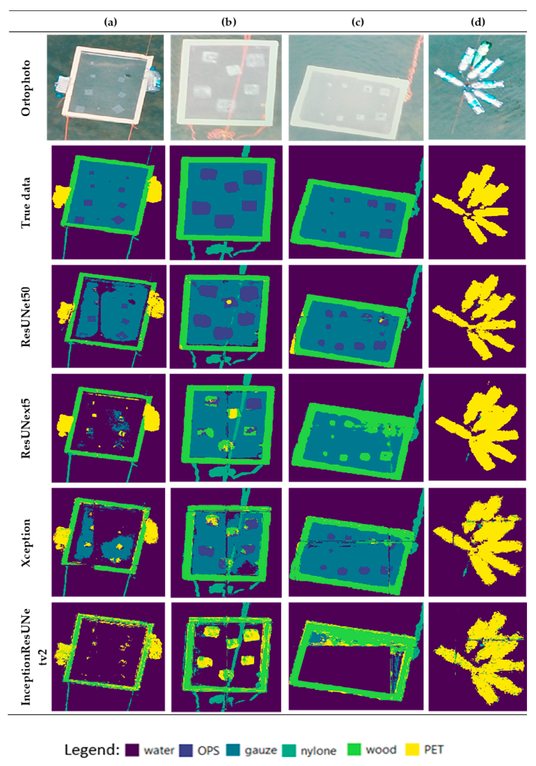
The WG 4.3 solution instead uses U-Net architecture (the ResUNet50 algorithm) with an encoder-decoder structure, to undertake image classification, including automatic classification, object detection and semantic segmentation. The encoder generates feature maps with high-level semantic but low resolution and the decoder upsamples the low-resolution encoder feature maps, retrieving the location information and obtaining fine-scaled segmentation results (Jakovljevic et al., 2020).
5.1 Pre-processing
Orthophotos are generated from the captured aerial imagery of each UAV survey. The pixel classes are delineated and labelled and then merged using multi resolution segmentation algorithms to create non-overlapping polygons.
As this research is the first attempt to map floating plastic data from UAV imagery, previous ground truthed data is not available and the delineation, classification and labelling is done manually. It is expected that the pre-processing time will reduce as the polymer ‘libraries’ grow, and this process becomes increasingly automated.
5.2 Classification
An end-to-end semantic segmentation model is used for floating and land based plastic classification based on the U-Net deep learning architecture (Fig. 3). The model consists of an encoder and a decoder. The encoder extracts and abstracts the image pixel information and the decoder extracts the plastic from the orthophotos.

5.3 Testing
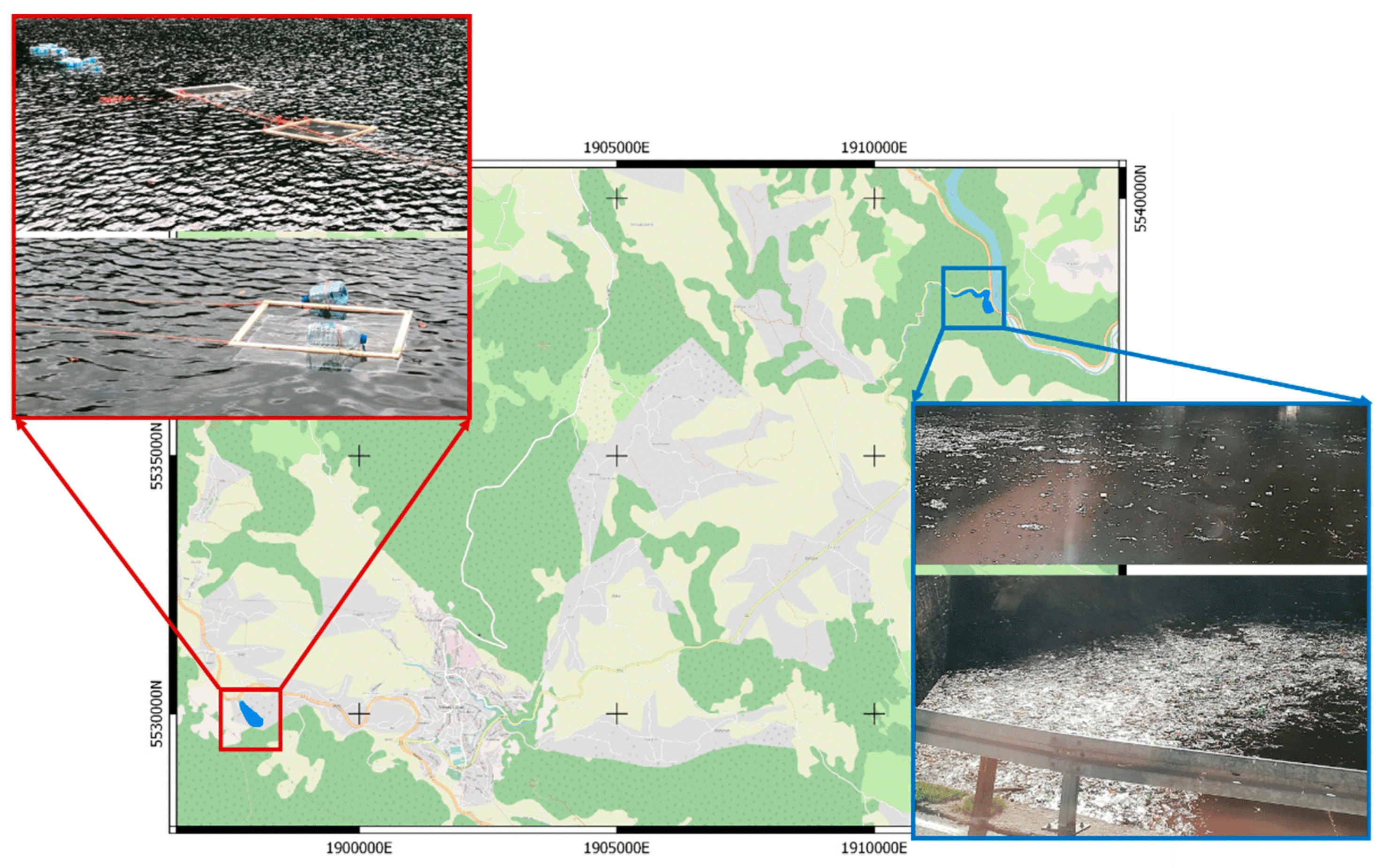
Testing and refinement of the plastic mapping solution has involved the processing of UAV imagery from two sites in Bosnia and Herzegovina (Fig. 6). One, at the confluence of the Crna Rijeka and Drina Rivers, was chosen because it is inundated with plastic and other waste, and the other, at Lake Balkana, is a pristine deep-water lake. They were chosen to test the algorithm’s ability to differentiate floating and submerged plastic from the surrounding water body and to test its ability to differentiate floating and land-based plastic from other litter (Fig. 5).
The algorithm detected plastic accurately in shallow water, which is a challenging environment for mapping plastic because the presence of the river bed increases water reflectance. Unexpectedly, the algorithm accurately extracted the plastic pieces that were omitted from the training data, showing good generalization abilities. The model also demonstrated its ability to detect plastic not just in water but also on land.

6 Plastic not seen: Mapping solution in Ghana
An example of this plastic mapping solution in action is in Ghana, where plastic pollution is severely impacting communities. The government has committed to addressing the problem and has implemented a National Plastic Action Partnership between the government, experts, civil society, community organizations, and the private sector. The Ministry of Environment, Science, Technology & Innovation (MESTI) plays a key role in its implementation.
6.1 The current situation
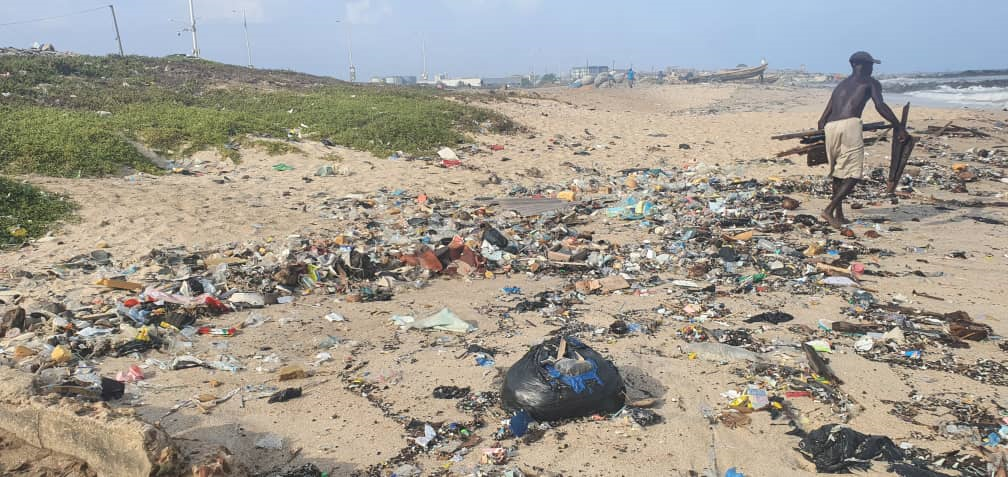
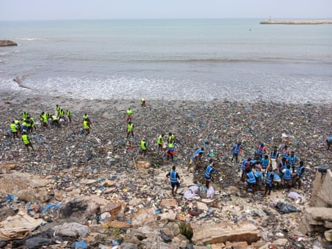
Ghana’s coastline is, unfortunately, impacted with plastic and other litter, in some places quite severely (Figs. 7 and 8).
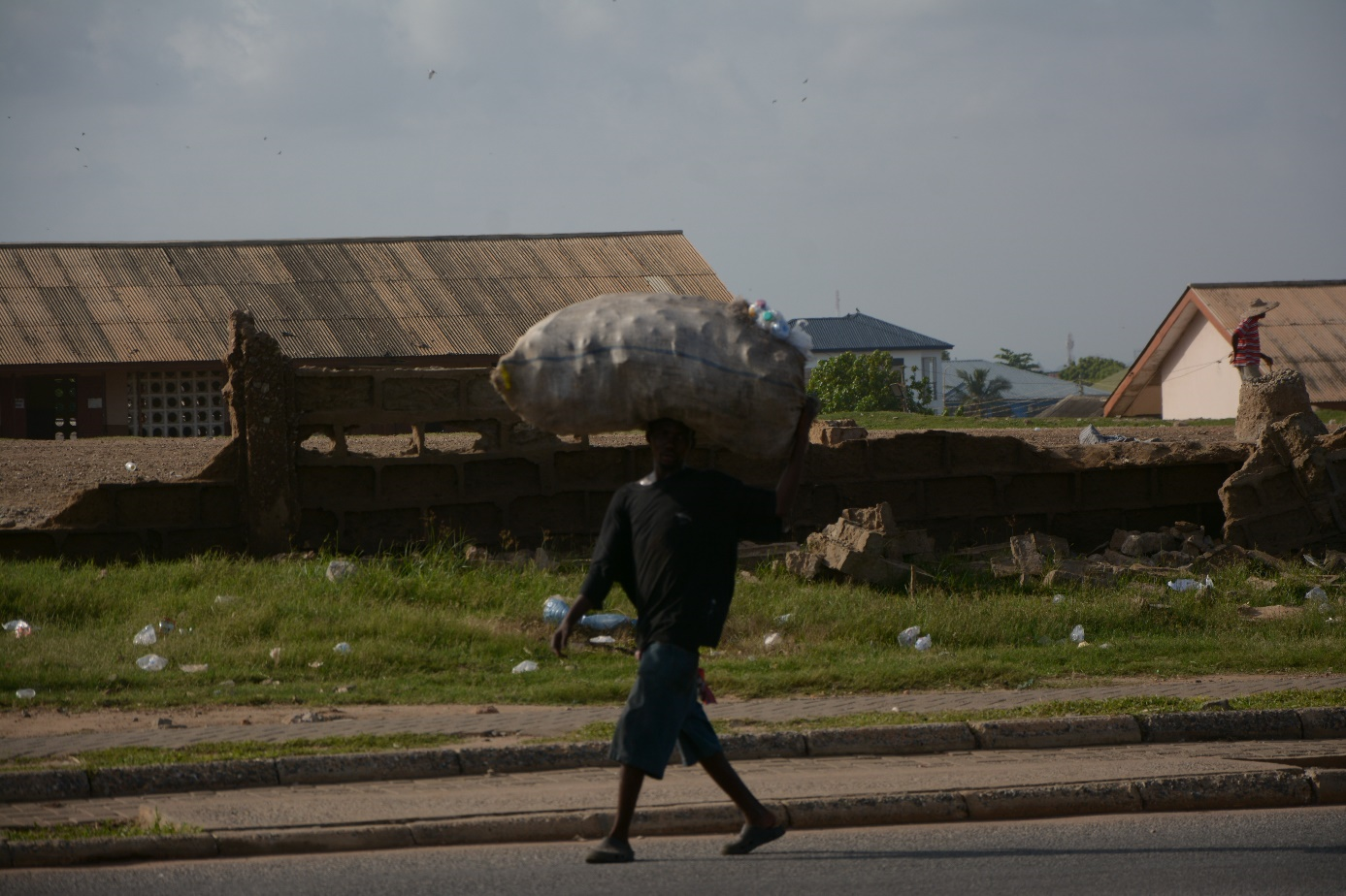
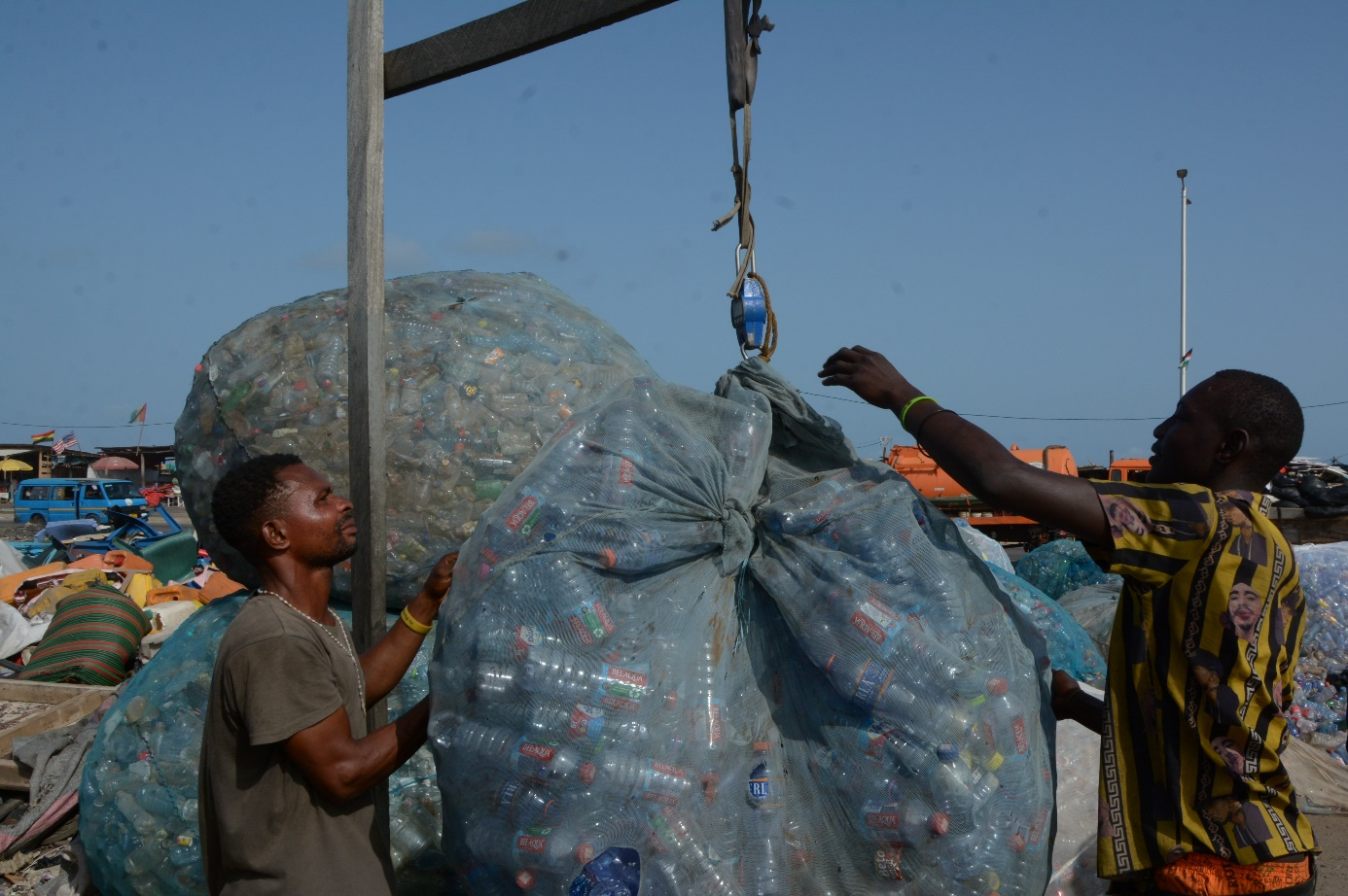
There is infrastructure available to recycle selected plastic waste, and, currently, informal recyclers scour the beaches and other locations for items of value, such as plastic bottles (Fig. 9). Payment is on a per-weight basis; however, the waste that has no value is left behind (Fig. 10).
6.2 Plastic not Seen
Based on the evaluation of preliminary UAV surveys undertaken at Korle Gonno Beach in Accra by students from the University of Mines and Technology, Takoradi under the supervision of Dr Naa Dedei Tagoe and processed by WG 4.3, MESTI is implementing the ‘Plastic Not Seen’ initiative.
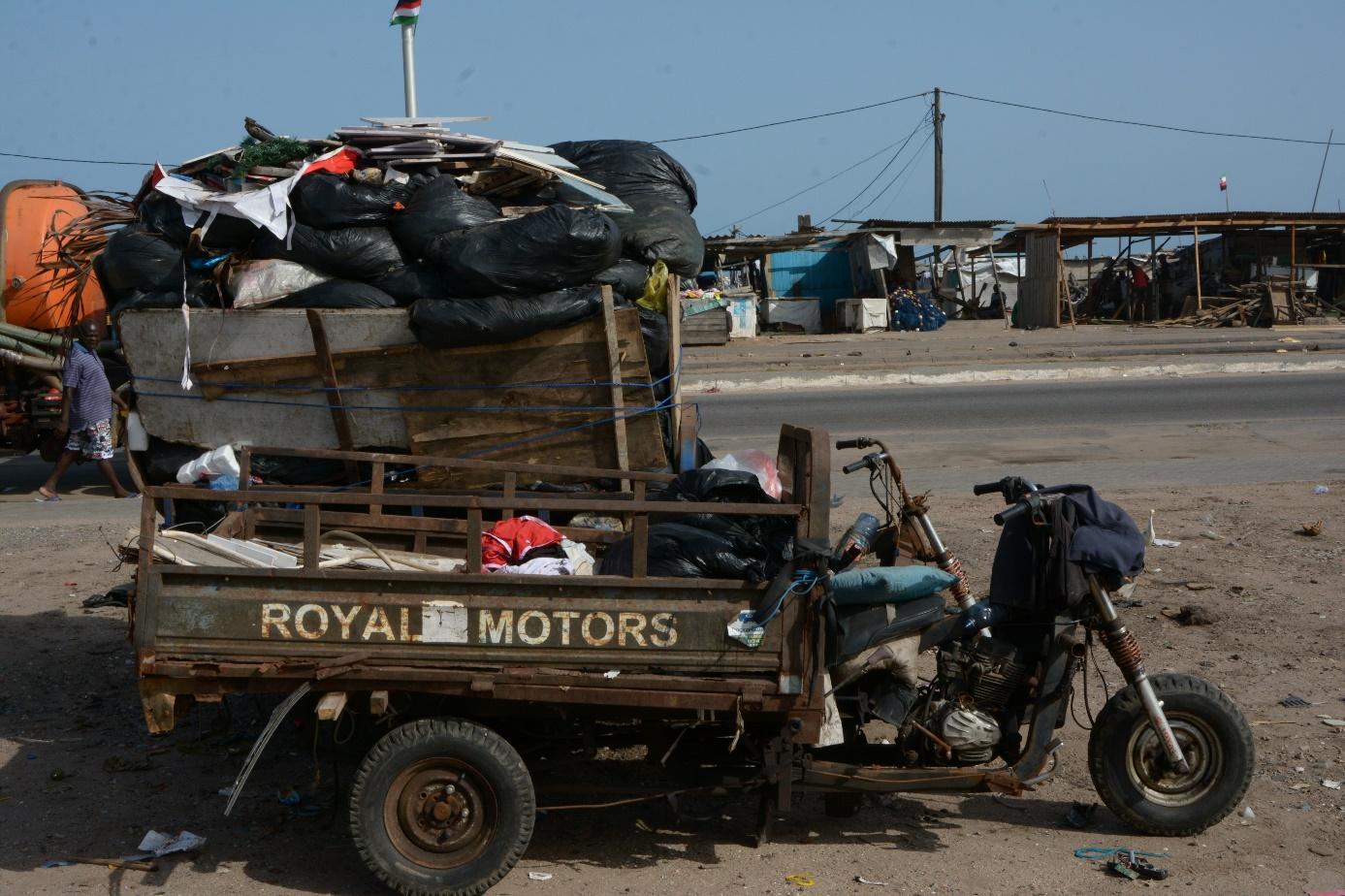
Korle Gonno Beach is one of many coastal locations throughout the country where informal settlements of indigent people eke out a subsistence living, part of which is recycling plastic waste (Fig. 11). The ‘Plastic Not Seen’ initiative is an expansion of the current informal recycling process, whereby local people are assigned a portion of coastline adjacent to their settlement and paid to clean it and keep it clean.
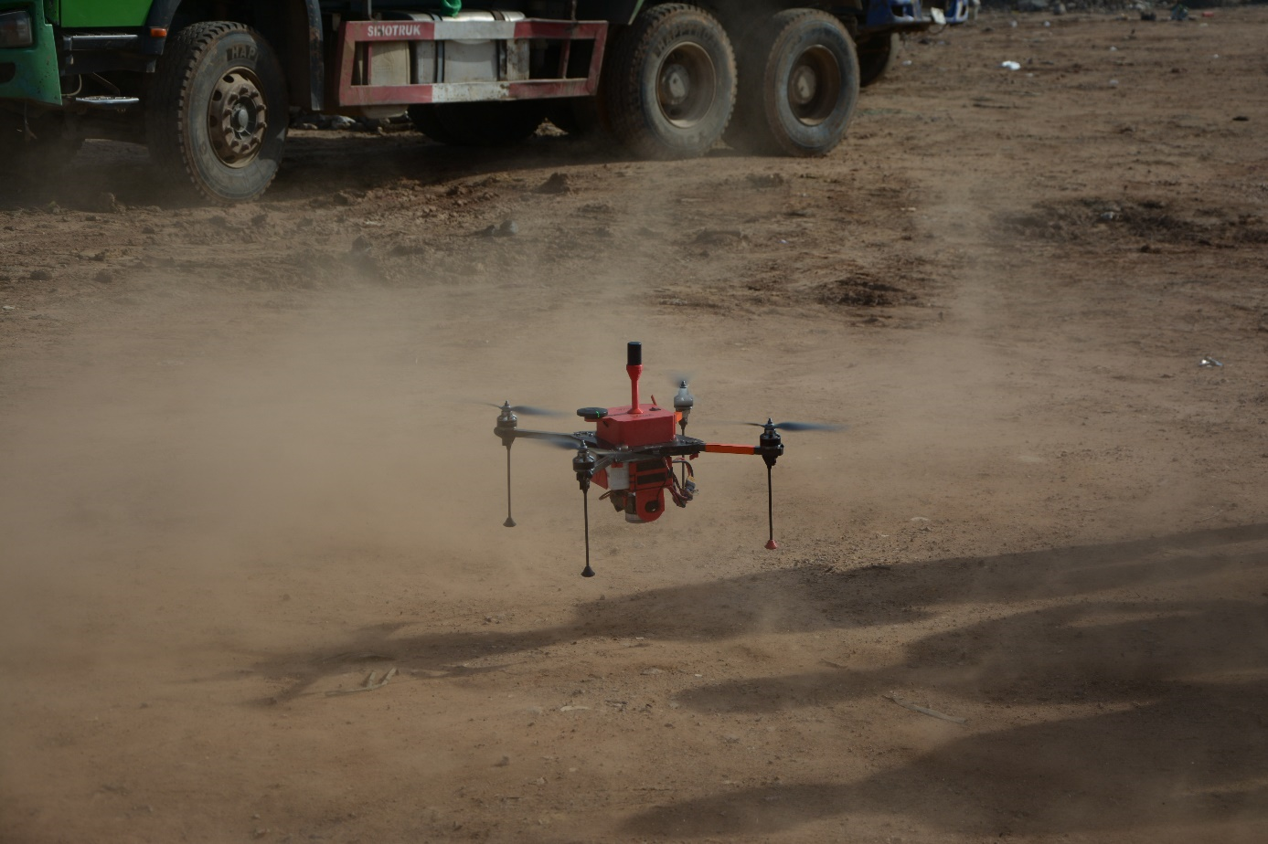
The work programme is currently being finalised. Initial UAV surveys at each location will establish the baseline waste levels with subsequent monitoring surveys undertaken to determine the level of compliance with the agreed clean up plan. The baseline and monitoring surveys will be undertaken locally with the captured imagery processed remotely, at least initially, by WG 4.3 (Fig. 12).
This approach has been chosen largely because the imagery and processed results accurately depict the situation at each location at any given time and there is no basis for misunderstanding or dispute about the amount of plastic seen or not seen by any of the parties involved.
Although not directly addressing the root causes of coastal pollution, it is an innovative and sophisticated step towards plastic waste eradication at a community level using this technology.
7 Policy enablement through accurate mapping and ongoing monitoring
This mapping solution is relatively inexpensive, requiring only a survey-specific UAV and a qualified pilot to capture the required data. The algorithms can be modified to identify other features, and the data can be processed remotely or locally depending on the available infrastructure. It can be used to inform policy changes in other areas.
7.1 Ocean governance and policy
Floating plastic and other litter are predominantly concentrated on the surface or within the upper limits of a water body. The deep learning algorithms have been trained to extract plastic and other litter from the surrounding water (salt or fresh) by differentiating the spectral signatures of the plastic and the water body. This methodology can be used to map plastic waste in marine environments, including the so-called ocean gyre ‘garbage patches,’ with UAVs deployed from a support vessel and the survey results processed onboard or remotely.
7.2 Coastal conservation and restoration
The WG 4.3 solution can also be used in coastal environments as the algorithm can detect plastic waste and other litter deposited on beaches and riverbanks. It is ideal for beach litter surveys (plastics and other debris), with the algorithms able to detect and classify plastic as small as 1.0 cm² to meet international litter assessment standards. The orthophotos from subsequent UAV surveys can be used to monitor the effects of restoration works over time. If required, the algorithm can be trained to differentiate and classify specific features as required. The only limitations are those that would impede UAV data capture, such as overhanging trees.
7.3 Equity and economic justice, particularly for small island states
UAV captured imagery and the processed data enables the communities in small island developing states (SIDS) to better understand the extent of the problems they face. It can also inform cases for equity and economic justice in international forums, and ongoing monitoring ensures adherence to international agreements.
7.4 Waste management
Accurate knowledge of the quantum of plastic waste and other litter in waterways and coastal areas assists in the formulation of action to eradicate their discharge into them. The captured imagery defines the baseline and informs policy and regulation. On-going monitoring provides accurate and quantifiable information against which adherence can be determined.
7.5 Climate change
UAV captured imagery is an effective way of monitoring land use patterns over time, and the algorithm can be adapted to interrogate specific items of interest. The data informs policy and regulator decision-making and provides affected communities, including indigenous communities and those living in SIDS, accurate information on critical climate change indicators such as sea-level rise or deforestation.
8 Conclusion
Although initially developed to map floating plastic in rivers and waterways to stop it adding to the huge amount of waste already in our oceans and so begin to ease their degradation, this mapping solution has also proven effective in mapping land-based plastic, thus broadening its scope. This cost-effective, sophisticated and accurate data capture and AI-based processing methodology provides the spatial information needed for effective land use control decisions and a monitoring tool to ensure the required outcomes are being achieved.
References
Barrett, J., Chase, Z., Zhang, J., Holl, M. M. B., Willis, K., Williams, A., Hardesty, B. D. and Wilcox, C. (2020). Microplastic Pollution in Deep-Sea Sediments From the Great Australian Bight. Front. Mar. Sci., 7:576170. https://doi.org/10.3389/fmars.2020.576170
Campbell, Gordon (2022). On The Global War Against Plastics. Scoop Media, New Zealand. https://www.scoop.co.nz/stories/HL2201/S00013/on-the-global-war-against-plastics.htm (accessed 15. October 2024).
Cheshire, A. C., Adler, E., Barbière, J., Cohen, Y., Evans, S., Jarayabhand, S., Jeftic, L., Jung, R. T., Kinsey, S., Kusui, E. T., et al. (2009). UNEP/IOC Guidelines on Survey and Monitoring of Marine Litter. UNEP Regional Seas Reports and Studies 2009, No. 186; IOC Technical Series No. 83: xii + 120 pp. https://www.nrc.govt.nz/media/10448/unepioclittermonitoringguidelines.pdf, (accessed on 25 April 2020).
Eriksen, M., Lebreton, L. C. M., Carson, H. S., Thiel, M., Moore, C. J., Borerro, J. C., Galgani, F., Ryan, P. G. and Reisser, J. (2014). Plastic pollution in the world’s oceans: More than 5 trillion plastic pieces weighing over 250,000 tons afloat at sea. PLoS ONE, 9(12), 9, e111913, https://doi.org/10.1371/journal.pone.0111913
Fava, M. (2022). Ocean plastic pollution an overview: data and statistics. Intergovernmental Oceanographic Commission of UNESCO. https://oceanliteracy.unesco.org/plastic-pollution-ocean/ (accessed 9 August 2024).
Hardesty, B. D., Lawson, T. J., van der Velde, T., Lansdell, M. and Wilcox, C. (2016). Estimating quantities and sources of marine debris at a continental scale. Front. Ecol. Environ., 15, pp. 18–25, https://doi.org/10.1002/fee.1447
Jakovljevic, G., Govedarica, M. and Alvarez Taboada, F. (2019). Remote Sensing Data in Mapping Plastic at Surface Water Bodies. Proceedings of the FIG Working Week 2019 Geospatial Information for A Smarter Life and Environmental Resilience, Hanoi, Vietnam, 22–26 April 2019.
Jakovljevic, G., Govedarica, M. and Alvarez-Taboada, F. (2020). A Deep Learning Model for Automatic Plastic Mapping Using Unmanned Aerial Vehicle (UAV) Data. Remote Sens., 12, 1515. https://doi.org/10.3390/rs12091515
Jambeck, J. R., Geyer, R., Wilcox, C., Siegler, T. R., Perryman, M., Andrady, A., Narayan, R. and Law, K. L. (2015). Plastic waste inputs from land into the ocean. Science, 347(6223), pp. 768–771.
McVeigh, K. (2022). Plastic summit could be most important green deal since Paris accords, says UN. The Guardian, Guardian News & Media Limited. https://www.theguardian.com/environment/2022/feb/25/plastic-summit-could-be-most-important-green-deal-since-paris-accords-says-un (accessed 9 August 2024).
Opfer, S., Arthur, C. and Lippiatt, S. (2012). NOAA Marine Debris Shoreline Survey Field Guide. National Oceanic and Atmospheric Administration, USA. https://marinedebris.noaa.gov/sites/default/files/ShorelineFieldGuide2012.pdf (accessed on 25 April 2020).
OSPAR commission (2010). Guideline for Monitoring Marine Litter on the Beaches in the OSPAR Monitoring Area (1st ed.). OSPAR Commission, London, UK. ISBN 90 3631 973 9. https://www.ospar.org/documents?v=7260 (accessed on 22 April 2020).
Schmidt, C., Krauth, T. and Wagner, S. (2017). Export of Plastic Debris by Rivers into the Sea. Environ Sci Technol., 51(21), 12246–12253. https://doi.org/10.1021/acs.est.7b02368
UNEP (2023). Turning off the Tap: How the world can end plastic pollution and create a circular economy. United Nations Environment Programme, Nairobi. ISBN: 978-92-807-4024-0.
UNEP (2024). Plastic Pollution. UN Environment Programme. https://www.unep.org/plastic-pollution/ (accessed 9 August 2024).
WWF (2022). Ocean plastic pollution to quadruple by 2050, pushing more areas to exceed ecologically dangerous threshold of microplastic concentration. World Wide Fund for Nature (WWF). https://oceanliteracy.unesco.org/plastic-pollution-ocean/ (accessed 9 August 2024).