
Abstract
1 Introduction
Let us have a look at the existing national and international regulations in force for the safety of navigation at sea. The International Maritime Organization (IMO) is the United Nations specialized agency with responsibility for the safety and security of shipping and the prevention of marine and atmospheric pollution by ships. The 1974 International Convention for the Safety of Life at Sea (SOLAS), together with subsequent amendments, has been adopted by the Member States of the IMO. Chapter V of SOLAS specifies the requirements for the navigational services to be used on board ships entitled to fly the flag of a party to the SOLAS Convention. The SOLAS Convention includes a requirement for all ships to carry up-to-date nautical charts and publications for the intended voyage. Progressively from 2012, the chart carriage requirement for certain classes of vessels is to be satisfied by electronic means using an Electronic Chart Display and Information System (ECDIS; IHO, 2018a).
IMO Member States are obliged to adopt IMO rules and regulations, such as those in SOLAS, into their national legislation. However, only when the Convention have been incorporated into national legislation do they take effect for the individual ships registered by that State. This process of incorporation into national legislation may vary from a few months to several years (IHO, 2018b).
The State in which a ship is registered and hence which flag it is flying is known as the Flag State. It is the national maritime administration representing the Flag State that controls the ship’s adherence to the SOLAS carriage requirements (Flag State control).
The national maritime administration is also responsible for Port State control. Ships arriving at a port may be subject to Port State control by local officials (Port State Control Officers, PSCO). Port State control is based on Flag State regulations and international agreements. Port States cooperate within regions to apply consistent standards; for example, European nations and Canada cooperate under the umbrella of the Paris Memorandum of Understanding1. Article 94 of the United Nation’s Convention on Law of the Sea (UNCLOS) defines responsibility on the flag state to carryout inquiry into marine casualty. Also, under SOLAS regulation I/21, Load Lines Convention article 23 and MARPOL articles 8 and 12, each Administration undertakes to conduct an investigation into any casualty occurring to ships under its flag. The Indian Maritime Administration conducts investigations and inquiries into marine casualties in accordance with Part XII of the Indian Merchant Shipping Act, 1958 (as amended; INDIA CODE, 2024). These inquiry reports are made available on the Directorate General of Shipping website1 aiming at preventing future accidents and generating awareness in mariners. In addition to IMO regulations, Marine Safety Act 1998 of India states its following objects:
- To ensure the safe operation of vessels in ports and other waterways,
- To promote the responsible operation of vessels in those waters so as to protect the safety and amenity of other users of those waters and the amenity of occupiers of adjoining land,
- To provide an effective framework for the enforcement of marine legislation,
- To provide for the investigation of marine accidents and for appropriate action following any such investigation,
- To consolidate marine safety legislation.
According to SOLAS-V, charts issued by or on the authority of a Government, authorized Hydrographic Office or other relevant government institutions are official and may be used to fulfil carriage requirements (provided they are kept up to date). All other nautical charts are by definition not official and are often referred to as unofficial or private charts. These charts are not accepted as the basis for navigation under the SOLAS Convention. There are two kinds of official digital nautical charts commonly available: Electronic Navigational Charts (ENC) or Raster Navigational Charts (RNC), where ENC are not available.
Besides the above regulations, Nautical Chart Working Group is a subsidiary of the HSSC (Hydrographic Services and Standards Committee) which provides expert and authoritative advice and guidance to relevant IHO bodies and non-IHO entities on the concept of nautical cartography including revision of IHO’s publications viz., S-4 Regulations for International (INT) Charts and Chart Specifications of the IHO, S-11 Guidance for the Preparation and Maintenance of International (INT) Chart and ENC Schemes and Catalogue of International (INT) charts, INT 1 (Symbols and Abbreviations used on Paper Charts), INT2 (Borders, Graduation, Grids and Linear Scales) and INT3 (Use of Symbols and Abbreviations). The aim of the international chart concept is to facilitate the provision of minimum sets of charts suitable for the navigational requirements of international (foreign-going) shipping. Such internationally-adopted charts will also enable those IHO Member States who provide, or wish to provide, charts outside their own national waters, to print by facsimile reproduction with only superficial modifications, selected modern charts under the terms of a bilateral arrangement between the Member States (IHO, 2018b). The purpose of INT charts and the INT chart product specifications will lose its identity as some of the Member Hydrographic Offices are heading towards paper less bridge. For example, Netherlands regulations allow paperless navigation and paper allowed as back up (IHO, 2020). Digital navigational aids may be of good accuracy but the lack of trained personnel at bridge lead to increase in number of accidents in comparison with the good old analogue navigational tools. The statistics below pertaining to marine accidents is a clear evident of the above statement.
2 Review of statistics – marine accidents
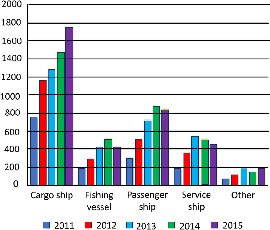
According to the European Maritime Safety Agency (EMSA)’s accident investigation reports on marine casualty, across the period 2011–2015 (EMSA, 2016), numerous fatalities occurred on board passenger ships. During 2015 itself, 115 reported fatalities, 976 persons injured, 36 ships lost and 125 investigations launched (EMSA, 2016). Over the period 2011–2015, half of the casualties were of a navigational nature (Fig. 1). Human erroneous action represented 62 % of accidental events and 71 % of accidental events were linked to shipboard operations as a contributing factor (European Marine Casualty Information Platform-EMCIP, 2016; Fig. 1). The total number of reported marine casualties and incidents over the period from 2014 to 2022 was 23,814, with a yearly average of 2,646 casualties and incidents. The total number of reported marine casualties and incidents in 2022 alone was 2,510 (EMSA, 2023).
In 2015 more than 1,700 cargo ships were involved in marine casualties and incidents that resulted in 64 fatalities, an abnormally high number due to the loss of the general cargo ship El Faro with 33 victims. In 2017, 1232 accidents (casualties and incidents) to UK vessels or in UK coastal waters were reported to the Marine Accident Investigation Branch (MAIB). These involved 1352 vessels. 42 of these accidents involved only non-commercial vessels, 499 were occupational accidents that did not involve any actual or potential casualty to a vessel. There were 708 accidents involving 779 commercial vessels that involved actual or potential casualties to vessels (MAIB, 2017).
The number of submissions in the Global Integrated Shipping Information System (GISIS) Maritime Casualties and Incidents (MCI) and reporting rate from 2010 to 2019 are shown below in Fig. 2.
According to Lloyd’s List Intelligence reports, incidents totalled 700 in the third quarter of 2022, the highest number of incidents since 2008. Machinery damage or failure, and collisions were the most common causes of casualty, accounting for 62 % and 12 % of all incidents during the year 2022. Incidents of this nature have been steadily increasing over the past decade (Fig. 3). During the first quarter of this year, accidents caused by machinery damage accounted for 57 % of all casualties, up from 40 % in the same period of 2015 (Fig. 4). Machinery damage or failures happen worldwide and impact all vessel types.


3 Analysis of accident investigation reports
According to paragraph 209 of the Casualty Investigation Code (CIC), “a marine casualty means an event, or a sequence of events, that has resulted in any of the death or serious injury to a person, loss of a person from ship, presumed loss or abandonment of a ship, material damage to ship, involvement of a ship in collision, material damage to marine infrastructure external to a ship, severe damage to the environment etc. However, a marine casualty does not include a deliberate act or omission with the intention to cause harm to the safety of a ship, an individual or the environment”2.
The following investigation reports pertaining to grounding of ships Kea Traders, Nova Cura, Muros and CMA CGM Vaco de Gama supports the above findings (Fig. 5).
Report by Marine Safety Investigation Unit (MSIU) on grounding of container ship Kea Trader: At 00551 on 12 July 2017, the Maltese registered container ship Kea Trader ran ground and stranded in position 22° 02.28′ S 168° 38.25′ E (Recif Durand) in the Pacific Ocean. At the time, the vessel was on a passage from Papeete, Tahiti, to Noumea, New Caledonia. Kea Trader was using electronic chart display and information system (ECDIS) as the primary means of navigation and there were no paper charts on board. The officer of the watch (OOW) was monitoring a route displayed on the ECDIS. The zone of confidence (ZOC) of the electronic navigation chart (ENC) was ‘D’ and displayed a caution symbol and textual message “[t]his chart cannot be accurately referred to WGS 84 datum; see caution message”.
The following findings in the Marine Safety Investigation Report No.14/2018 by the MSIU is a clear evident of untrained staff and malfunctioning of the equipment at the bridge (MSIU, 2018):
- The revised route resulted in the track virtually passing over the isolated danger;
- The second mate’s observation of the isolated danger symbol appearing outside the starboard XTL (Cross Track Limit) due to an over-scaled ECDIS display, led to the incorrect assumption of safe water within the XTL corridor;
- An over-scale indication and vertical lines on the ECDIS indicating positional discrepancy of charted objects and loss of navigational information was missed by the OOW;
- No warnings or reference to the isolated danger was documented;
- The ECDIS route check function had not been enabled;
- The master’s confidence in the second mate’s competency in the use of ECDIS, and application of planning procedures led him to believe that the route was safe and no independent route check was carried out;
- The detection vector had a width of 0.1 nm and 1.9 nm ahead and the detection sector was set at 45° over the same distance, effectively giving the OOW just about six minutes to respond to the safety alarm;
- Since the safety settings during the navigational watch hand over were neither checked nor logged in the deck logbook, none of the watchkeepers was aware of the actual safety settings on the ECDIS;
- The audible alarm was set to zero and remained switched off during the vessel’s passage to Noumea;
- The displayed symbol had not been interrogated;
- The ‘caution area’ message repeatedly displayed in the subsequent navigational watches was largely overlooked by the bridge team;
- The OOW earnestly believed that the vessel’s position displayed within the XTL was safe and required no action other than of adjusting the heading to regain the track;
- No evidence of the safety alarm – crossing safety contour, approaching underwater rock / obstruction / wreck or dangerous symbol – was found triggered on the ECDIS to alert or indicate to the OOW or lookout of imminent danger of grounding;
- The fact that the isolated danger symbol on the chart and the caution area message in the alarm panel remained displayed during successive navigational watches, may have suggested that there were no immediate and/or perceivable effects on the vessel or the voyage per se;
- The benefits of technology became a burden, hindering the skillful use of equipment and only mitigated by the de-activation of the safety barrier system.
Report by Dutch Safety Board (DSB) on grounding of Dutch ship Nova Cura: On 20 April 2016, the Dutch freighter Nova Cura was en-route from Eregli on the Black Sea (Turkey) to Aliaga (Turkey). The ship was loaded with 4,400 tonnes of steel products. At 09:551 hours the Nova Cura ran aground in Mytilini Strait (to the north of Lesbos) at operating speed. As a result, all of the double-bottom tanks were breached and filled with water, as was the engine room and the bow thruster room. The ship was a total loss. The digital chart in the ECDIS (Electronic Chart Display and Information System, indicated that the sea should be 112 metres deep at the ship’s position. However, the ship appeared to have run aground in shallow water at Lamnas Reef. This accident is classified as a very serious accident as referred to in the Casualty. On the day of the grounding, 20 April 2016, the Nova Cura was en-route from Eregli (Turkey) to Aliaga (Turkey) carrying 4,400 tonnes of steel products. This gave the ship a draft of 5.80 meters. (Source: Investigation Code of the International Maritime Organization (IMO) and EU Directive 2009/18/EC).
United Kingdom Marine Accident Investigation Branch (MAIB): On 2 December 2015 the 2,998 gross ton Spanish bulk carrier Muros (Fig. 2), carrying a cargo of bulk fertilizer, was en-route from Teesport (United Kingdom) to Rochefort (France). The vessel’s original Passage Plan had the vessel transiting through North Hinder Junction. During the watch handover from the Master to the Second Officer (2/O), occurring from 2350 (2 December 2016) to 0010 (3 December 2016), the Master ordered the 2/O to amend the Passage Plan to transit via the Sunk Traffic Separation Scheme (Fig. 1). The vessel went aground on a falling tide on Haisborough Sand off the east coast of the United Kingdom in the early morning hours of 3 December 2016, about 2 hours after the watch handover. The vessel remained aground for 6 days before being refloated. Rudder damage required the vessel be towed to Rotterdam for repairs (Source: The MAIB Report No. 22/2017 was released on 19 October 2017). The possible cause of the grounding was an unsafe Passage Plan resulting from changing the vessel transit from via North Hinder Junction to via Sunk Traffic Separation Scheme.
Grounding of Ultra-large container vessel CMA CGM Vasco de Gama: In the early hours of the morning on 22 August 2016, the 399.2m ultra-large container vessel CMA CGM Vasco de Gama, grounded on the western side of the Thorn Channel whilst approaching the Port of Southampton. CMA CGM Vasco de Gama was the largest ship on the UK ship registry and had two Southampton pilots embarked. One of the pilots had control of the vessel’s navigation at the time of the grounding. Fortunately, CMA CGM Vasco de Gama was undamaged by the grounding and was able to be refloated, with tug assistance, on the rising tide. The grounding occurred because the vessel was too far north of the intended track when the turn into the Thorn Channel was commenced. This reduced the sea room available for the maneuver and, given the environmental conditions, CMA CGM Vasco de Gama was unable to sustain the rate of turn required to remain in the dredged channel.
The execution of the vessel’s turnaround Bramble Bank and into the Thorn Channel by the lead pilot was not in accordance with the port’s guidance for large inbound vessels. CMA CGM Vasco de Gama’s bridge team, assistant pilot and the Vessel Traffic Services, could not usefully monitor the lead pilot’s actions, or the vessel’s progress through the Precautionary Area. This was because a detailed pilotage plan had not been produced; the lead pilot’s intended maneuver around Bramble Bank was not explained; the bridge team roles and responsibilities were unclear; and the electronic navigation aids on board were not fully utilized.
The investigation identified that the vessel’s bridge team and the port pilots had the experience, knowledge and resources available to effectively plan and execute the pilotage. However, the standards of navigation displayed during the pilotage fell short of the standards expected by CMA Ships and Associated British Ports. It was apparent that complacency and a degree of over confidence on the part of the master and port pilots contributed to this accident. However, it was also apparent from recent similar incidents and the findings of previous MAIB reports that many of the practices evident in this case were not specific to this single pilotage act, or to CMA CGM Vasco de Gama.
Actions have been taken by CMA Ships and Associated British Ports to address some of the issues identified in this report and to improve navigational safety. The findings of this report will be used by the MAIB as part of a safety study that will investigate the use of modern electronic navigation aids on board merchant vessels, and the impact they have had on navigation practices. Recommendations aimed at reducing the likelihood of future groundings and improving levels of navigation, bridge resource management, and use of electronic navigation aids have been made to CMA Ships and Associated British Ports.
Grounding of Muros: At 0248 (UTC+1) on 3 December 2016, the bulk carrier Muros ran aground on Haisborough Sand on the east coast of the United Kingdom. Attempts to maneuver clear of the shallows were unsuccessful but the vessel was re-floated 6 days later with tug assistance (Fig. 5). There were no injuries and no pollution, but damage to Muros’s rudder necessitated the vessel being towed to Rotterdam, Netherlands, for repair.
The MAIB investigation identified the following shortfalls:
- The vessel was following a planned track across Haisborough Sand. The passage plan in the ECDIS had been revised by the second officer less than 3 hours before the grounding and it had not been seen or approved by the master.
- A visual check of the track in the ECDIS using a small-scale chart did not identify it to be unsafe, and warnings of the dangers over Haisborough Sand that were automatically generated by the system’s ‘check route’ function were ignored.
- The second officer monitored the vessel’s position using the ECDIS but did not take any action when the vessel crossed the 10m safety contour into shallow water.
- The effectiveness of the second officer’s performance was impacted upon by the time of day and a very low level of arousal and she might have fallen asleep periodically.
- The disablement of the ECDIS alarms removed the system’s barriers that could have alerted the second officer to the danger in time for successful avoiding action to be taken.
The MAIB has recently investigated several grounding incidents in which the way the vessels’ ECDIS was configured and utilized was contributory. There is increasing evidence to suggest that first generation ECDIS systems were designed primarily to comply with the performance standards required by the IMO, as these systems became a mandatory requirement on ships, with insufficient attention being given to the needs of the end user. As a consequence, ECDIS systems are often not intuitive to use and lack the functionality needed to accommodate accurate passage planning in confined waters. This situation has led to seafarers using ECDIS in ways which are at variance with the instructions and guidance provided by the manufacturers and/or expected by regulators (MAIB, Report on the investigation of the grounding of Muros Haisborough Sand North Sea 3 December 2016).
The MAIB is conducting a safety study, in collaboration with the Danish Maritime Accident Investigation Board, designed to more fully understand why operators are not using ECDIS as envisaged by regulators and the system manufacturers. The overarching objective is to provide comprehensive data that can be used to improve the functionality of future ECDIS systems by encouraging the greater use of operator experience and human centred design principles (MAIB Report no. 22/2017 of October 2017).
The recent accident which was happened on 26 March 2024, where a cargo ship named Dali was slammed into the ‘Francis Scott Key Bridge’ at Baltimore, Maryland State, United States of America. The central part of the bridge is completely collapsed. The preliminary reports from the news agencies says that there was a power issues with the ship prior to collision and the crew made a mayday message to the authorities. Six construction workers who were working on the bridge are missing and presumed to be dead according to the news agency reports (BBC, 2024). The ship owner declared that entire 23-member crew onboard are safe. Since the bridge which was constructed in 1977, is a main life line for the trade in this area, the entire business came to a halt. The collapse of the bridge had an impact on the supply chain and worsely affected the ship movement into entry and exit of the Baltimore harbour. Detailed accident investigation report is awaited. Fig. 6 shows the allision of Dali against the bridge.


4 Conclusion
In the name of technological advancements in the field of navigational equipment, we are deviating from the main objective i.e., safety of life at sea. The rapid technological growth in the marine sector causes delay in familiarization of existing resources. For example, the use of S-57 ENCs started in the early 2000 and the manufacturers had produced the S-57 compliant ECDIS. When the mariner not fully familiar and user friendly with the existing functions of ECDIS, IHO has switched over to S-100 (IHO Universal Hydrographic Data Model) series of products with the respective specifications including ECDIS display standards S-52. Now it is the time for the ECDIS manufactures to produce machines that are compliant with the S-1xx series of products for example S-101(ENC), S-102(Bathymetric Surface), S-104 (Water Level Information), S111(Surface currents), S-129(Under Keel Clearance Management) etc., under phase-I of S-100 implementation road map of IHO (S-100 Implementation Strategy) with relevant software upgradations including WECDIS to read AMLs. In the bargain the men at bridge neither fully conversant with the existing tools nor getting familiar with the upgraded software/hardware tools which may lead to a wrong judgment yet times.
Let us analyse the marine investigation report on grounding of bulk carrier American Mariner. On January 7, 2023, about 0734 local time, the bulk carrier American Mariner had begun transiting outbound in the Vidal Shoals Channel, near Sault Ste. Marie, Ontario, en route to Superior, Wisconsin, when the vessel grounded and sustained damage to three ballast water tanks (see Fig. 7). No pollution or injuries were reported. Damage to the vessel was $600,000 (MIR-24-16 by the NTSB). The National Transportation Safety Board (NTSB) determines that the probable cause of the grounding of the bulk carrier American Mariner was the master manoeuvring the vessel away from the dock and into the channel while alone on the bridge, which required him to multitask (navigation, steering, and lookout duties) and resulted in the vessel overshooting the turn into the channel and running aground on the shoals on the opposite side of the channel. American Mariner was outfitted with a RosePoint electronic chart system (ECS). The ECS was not configured to display the footprint of the vessel, according to the master, and safety depths were not programmed into the ECS. Which shows the un-familiarisation of bridge crew with the safety functions of the ECS system.
The NTSB report also opined that while manoeuvring in confined waters, it is difficult for a single bridge crewmember to effectively drive, lookout, and monitor and use available bridge equipment. The composition of a bridge team may vary based on the complexity of the manoeuvre or operation being carried out. Typically, manoeuvres like docking or undocking, transiting in or out of port, or operating in areas of high traffic density require additional personnel to handle navigation-related duties. Owners, operators, and vessel masters are responsible for ensuring that bridge teams are staffed with a sufficient number of certified/credentialed mariners who are familiar with all bridge navigation equipment and able to independently take immediate action. Additionally, the effective use of all available resources by a bridge team, including visual scanning, radars, electronic charts, and an automatic identification system (AIS), increases collective situational awareness and contributes to a safe navigation watch (NTSB, 2016).
Therefore, at most care must be taken to avoid human negligence while exercising safety measures onboard. Language should not be a barrier while imparting safety information. Technological changes must improve the safety of life at sea rather increasing risk factor. The crew must be trained in using digital navigational tools and ability to comprehend the resources their alarms on an ECDIS to overcome the risk. Awareness towards latest IHO standards and specifications pertaining to ENC/ECDIS is essential. Mariner must keep an updated ENC sets from an authorized hydrographic office, onboard for the planned voyage.
In the recent allision of the cargo ship Dali which slammed the Francis Scott Key bridge at Baltimore port, the ship was identified a faulty pressure gauge for fuel heating by the authorities and the same was fixed before the ship leaving from the port at Singapore. Just before the allision, the Dali experience a blackout losing power and its steering control system. Such blackouts are rare but hazardous on ships. The preliminary reports say that the impure fuel used might be one of the reasons for power failure. The ship was undergoing routine engine check-up just before the collision. Human negligence and dilution of standards may be the cause of this particular accident. However, a detailed accident investigation report is awaited in this case.
The above statistics are the clear evidence of increasing marine accidents in the past two decades as we have been claiming the era of artificial intelligence. In the name of safety, too much research had been taken place towards developing new software and hardware that can replace the use of hard copies of charts and other navigational publications onboard. The increase in number of marine accidents is the clear indication that the main objective viz., “safety of life at sea” has not been achieved with the technological upgradation. Moreover, the change of face at bridge onboard a ship is industry driven irrespective of the adoption and familiarization of technology by the personnel onboard. In other words, the mariner could not keep up pace with technological advancements which are leap frogging and mariner is at a snail’s pace. The charm of being at sea is at the risk of life versus economic benefits. Lack of knowledge in marine cartography, improper procedures followed by the untrained manpower with least exposure to ECDIS display and its alarms and warning while navigating through unfamiliar waters will increase the probability of risk to the ships.
The following are recommended to reduce the risk of marine incidents and to overcome the shortfalls while using digital navigational tools onboard:
- Training on use of navigational equipment including ECDIS to the bridge crew is mandatory.
- ECDIS system and procedures which safeguards intended to prevent groundings must be strictly followed. In case of amended Passage Plan if any must be thoroughly checked on an appropriate scale to avoid the mismatch.
- Visual checks while planning the passage must be on desired scale rather using “standard” chart view.
- Audible alarms must be enabled.
- The upgraded versions of the ECDIS machines and the software which are compliant to IHO standards and specifications are recommended.
- Familiarization of on-board navigational equipment including ECDIS to the bridge team is very essential.
- Detailed reporting on bridge activity including change of passage if any by the navigating officer on duty to the second officer while handing over the charge is very important.
- Master must check or approve the amended Passage Plan prior to execution.
- Comfortable duty hours, good health and mental status of the navigating team at bridge must be given high priority to overcome the inefficiency due to fatigue.
- No compromise on standards to be maintained onboard whether it is equipment, fuel and procedures to follow.
- Safety should be given at most priority.
References
Fox, BBC (2024). Baltimore bridge collapse: Six presumed dead after ship collides with bridge. British Broadcasting Corporation (BBC). https://www.bbc.com/news/world-us-canada-68663318 (accessed 26 October 2024).
EMSA (2016). Marine Casualties and Incidents. Summary Overview 2011–2015. European Maritime Safety Agency. https://www.emsa.europa.eu/component/flexicontent/download/4685/3011/23.html (accessed 26 October 2024).
EMSA (2023). Annual Overview of Marine Casualties and Incidents 2023. European Maritime Safety Agency. https://emsa.europa.eu/component/flexicontent/download/7639/2713/23.html (accessed 26 October 2024).
ICS (2024). International Chamber of Shipping. https://www.ics-shipping.org (accessed 26 October 2024).
IHO (2018a). Facts about Electronic Charts and Carriage Requirements (1st ed.). IHO Special Publication S-66, International Hydrographic Organization, Monaco. https://iho.int/iho_pubs/standard/S-66/S-66%20Edition%201.1.0_Final_Clean.pdf (accessed 26 October 2024).
IHO (2018b). Resolutions of the International Hydrographic Organization (2nd ed.). IHO Publication M-3, International Hydrographic Organization, Monaco. https://iho.int/iho_pubs/misc/M3-E-AUGUST18.pdf (accessed 26 October 2024).
IHO (2020). The Future of the Paper Nautical Chart – Final Report. Nautical Cartography Working Group (NCWG), International Hydrographic Organization, Monaco. https://iho.int/uploads/user/Services%20and%20Standards/HSSC/HSSC12/2020-08-28%20Future%20of%20the%20Paper%20Nautical%20Chart%20Final%20Report%20FINAL.pdf (accessed 26 October 2024).
INDIA CODE (2024). INDIA CODE. Digital Repository of Laws – A system of laws for communication. https://www.indiacode.nic.in (accessed 26 October 2024).
MAIB (2017). Report on the Investigation of Grounding of Muros. Report no. 22/2017, Oct 2017, Marine Accident Investigation Branch. https://www.transportes.gob.es/recursos_mfom/maibinvreport_22_2017.pdf (accessed 26 October 2024).
MSIU (2018). Safety Investigation into the grounding of the Maltese registered container ship Kea Trader. Report No. 14/2018, Marine Safety Investigation Unit.
NTSB (2016). Grounding of the Bulk Carrier American Mariner. Marine Investigation Report MIR-24-16, National Transportation Safety Board, USA. https://www.ntsb.gov/investigations/AccidentReports/Reports/MIR2416.pdf (accessed 26 October 2024).