


Abstract
1 Introduction
The Dique Channel is an artificial bifurcation of the Magdalena River that enables its navigation towards Cartagena Bay. It was constructed during the Spanish colonial period in the 16th century. Presently, the outlet of the Dique Channel into Cartagena Bay is a distinctive area due to the transit of cargo vessels. This, combined with the high sedimentation generated by the river’s flow, turns this area into a critical location for navigation. The Dique Channel represents a fluvial contribution with transport of fine terrigenous sediments (0–31 μm) (Lonin et al, 2004). According to Tosic, Restrepo, Lonin, Izquierdo and Martins (2018), historical records indicate an average flow rate of 398 m3s-1 before 2000 and an increase to 508 m3s-1 during the period 2000–2010. Also, sediment load displayed an increase of 48 % when comparing the mean load of 16,153 t/day during the 1984–2000-year period with the observed inter-annual mean of 23,906 t/day for the 2005–2010-year period. These results are in close agreement with the observed trends during the period between 1980 and 2010 in sediment loads of the main tributaries of the Magdalena River and also with the steep increase in deforestation during the last three decades.
The Colombian Maritime Authority, through the Caribbean Center for Oceanographic and Hydrographic Research, conducted hydrographic surveys at the mouth of the Dique Channel in January 2023. The objective was to characterize the seafloor and carry out various multi-temporal analyses, considering other hydrographic surveys conducted in the same area but in different years (2012 and 2020). This was done to understand the dynamics and influence of the Dique Channel on Cartagena Bay. This effort aims to provide scientific information to support decision-making for the benefit of maritime activities in the region, ensuring comprehensive maritime safety. It contributes to the country’s development and the protection of natural resources and the environment, serving as fundamental pillars within the guidelines of the Colombian national government1.
2 Study area
Cartagena Bay located in the northwestern part of South America, within the Colombian Caribbean, between 10°16’N–10°26’N and 75°36’W–75°30’W (Fig. 1). The mouth of the Dique Channel is located to the southeast of Cartagena Bay. This discharges sediments directly into the bay, creating a sediment lobe (SL) consisting of a sedimentary deposit of fluvial origin, which due to its muddy and shallow condition makes it difficult to carry out a bathymetric survey. (Villanueva-Garcia et al., 2022)
3 Data collection
The last hydrographic survey was conducted in order 1b according IHO specification S-44 Edition 6.1.0. This data was compared with the data from 2012 and 2017 using the software Hypack.
The 2023 survey was conducted onboard the Soundermax hydrographic boat (Fig. 2), using a single beam system with echosounder Teledyne Odom Echotrac, DGPS Trimble R7 and SVP AML Base X2. The devices were used for collecting bathymetric information, for ensure optimal functioning of each peripheral component of the system.
The hydrographic survey using the singlebeam system at the mouth of the Dique Channel was carried out on the days of December 13th, 14th, and 16th, 2022, and on January 19th, 2023. The initial planning was conducted using Hypack software version 2022, with the most update electronic chart of the study area as the foundation. The main consideration was to determine the outbound route of the Dique Channel to a depth of 20 m, which is considered a safe water area for navigation, taking into account the types of vessels transiting the area.

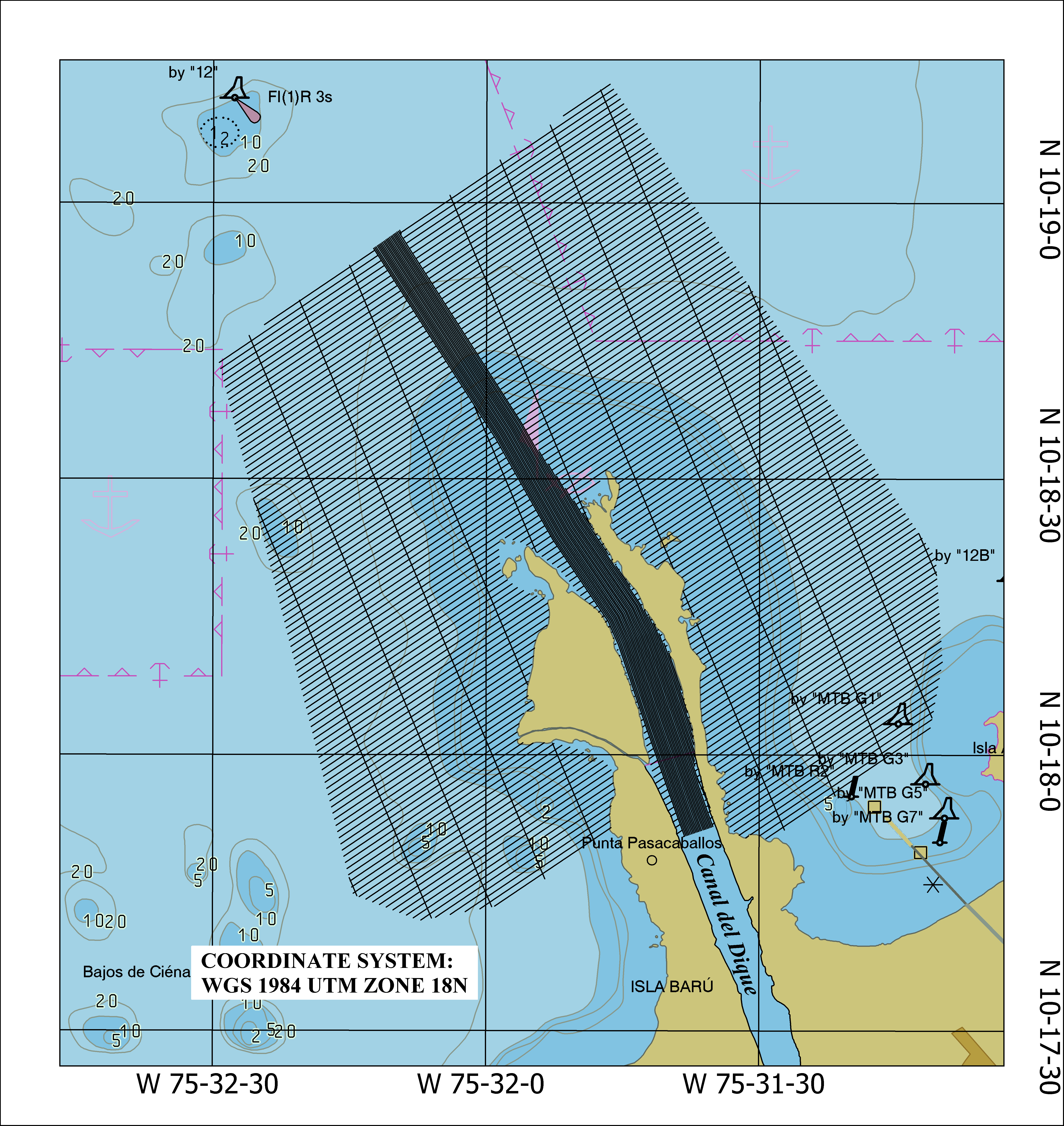
Upon entering the study area, two safety lines were conducted to determine areas of shallower depth, revealing significant variations in the bottom morphology due to the high sedimentation caused by the river. This prompted a reevaluation of the initial study area to fulfill the primary objective of identifying safe waters in Cartagena Bay. To achieve this, longitudinal lines were planned every 5 m and transverse lines every 150 m at the mouth of the Dique Channel, aiming to determine the navigable area and average depth. Outside the canal, perpendicular lines to the coast were planned with a 20-meter spacing for run lines and 200 m for check lines. In accordance with the IHO Standards for Hydrographic Surveys S-44, 6th Edition, the survey is classified as Order 1b because a uniformly distributed bathymetric coverage of 5 % of the survey area is available. This means that some features may not be detected, but the distance between the areas of bathymetric coverage will limit the size of those undetected features. (IHO, 2020).
During the survey, the Teledyne Odom Echotrac CVM single beam echosounder was employed to measure depth. This echosounder features a dual-frequency transducer (38 kHz and 200 kHz), which was installed at the stern of the vessel to acquire data through the acoustic window method, using the high frequency of 200 kHz for shallow waters to avoid the penetration of the sound wave into the seabed due to the type of muddy sediment found in the study area. For positioning, the GNSS receiver Trimble R7 with Fugro Marinestar satellite differential signal was used. The AML Base X2 profiler was employed to determine the speed of sound in the water, while water level corrections were made using data from the vertical tide network of the Colombian Maritime Authority, with the data referenced to Mean Lower Low Spring (MLWS).
The software used for data collection, processing, and analysis was Hypack version 2021. Through its Hypack Survey module, this software enabled the configuration of data reception from each peripheral to obtain location information on the nautical chart and monitor the echosounder coverage.
4 Coverage area
A total area of 2 km² was successfully covered using the single beam system over the course of 4 days of hydrographic survey, in accordance with the initial plan. A minimum depth of 0.8 m and a maximum depth of 25 m were determined.
During this study, a depth of 1.2 m was verified and plotted on ENC CO500261, near buoy No. 18 of the navigable channel of Cartagena Bay, located in front of the mouth of the Dique Channel. When carrying out hydrographic search lines on the shallows, it was determined that this depth did not correspond to current conditions, since depths of 7 m were previously recorded in the area (Fig. 4).
This information is of great importance for the update the ENC CO500261 “Cartagena Bay”.

Fig. 4 Coverage area of 2023 survey and depth verification.
5 Analysis of the information
The analysis of the information was conducted using the data collected in the year 2023 (Fig. 7), which were compared with the most recent studies of the same area. This information is stored in the hydrographic database of the Caribbean Center for Oceanographic and Hydrographic Research and corresponds to surveys conducted in the years 2012 and 2020 (Figs. 5 and 6).
The data from 2012 correspond to those used at that time for the update of ENC CO500261 “Cartagena Bay”, these were acquired with 200 kHz single-beam systems and the data from 2020 correspond to a monitoring carried out by the Caribbean Oceanographic and Hydrographic Research Center where a 200 kHz single-beam system was also used.
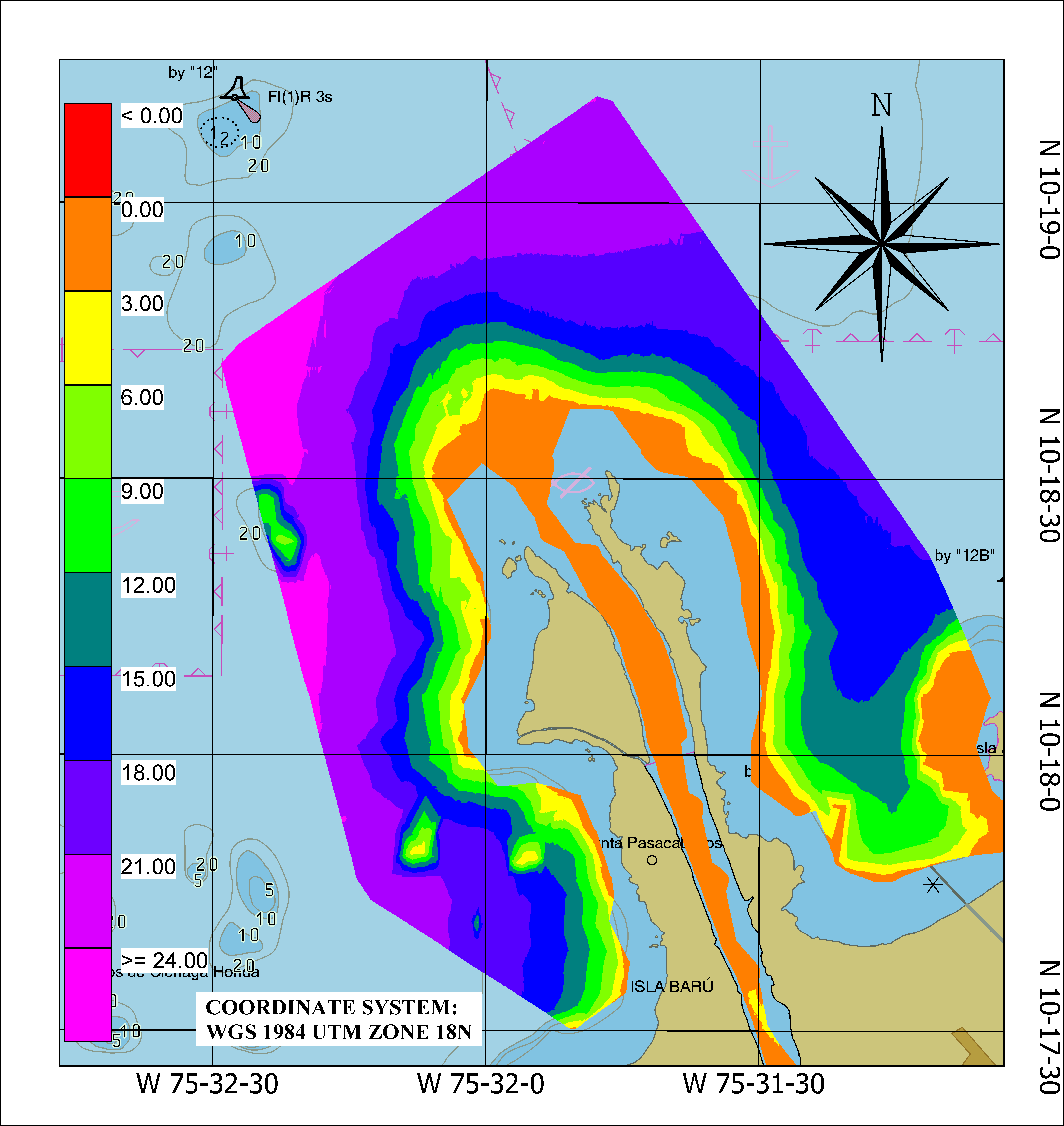
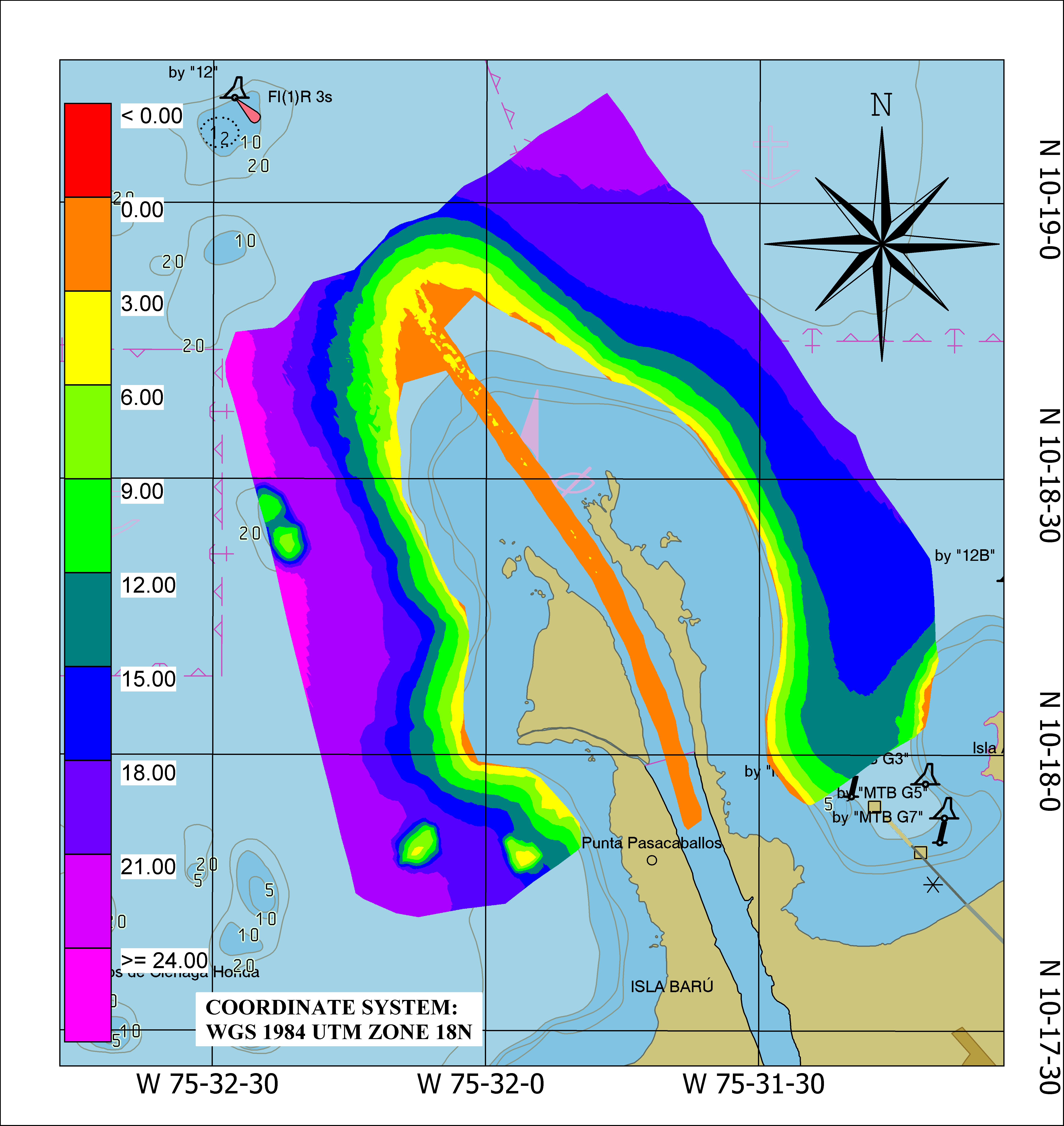

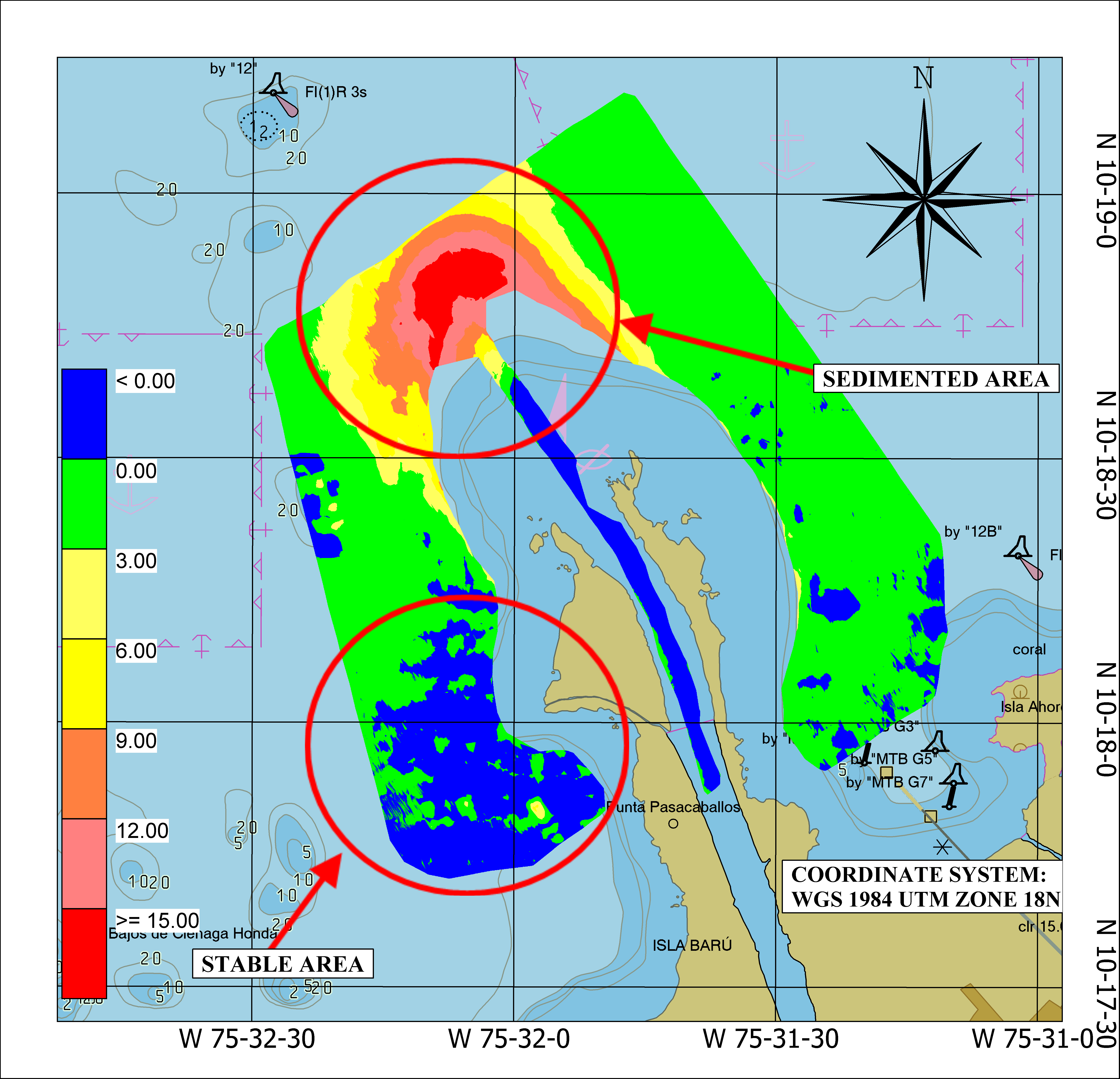
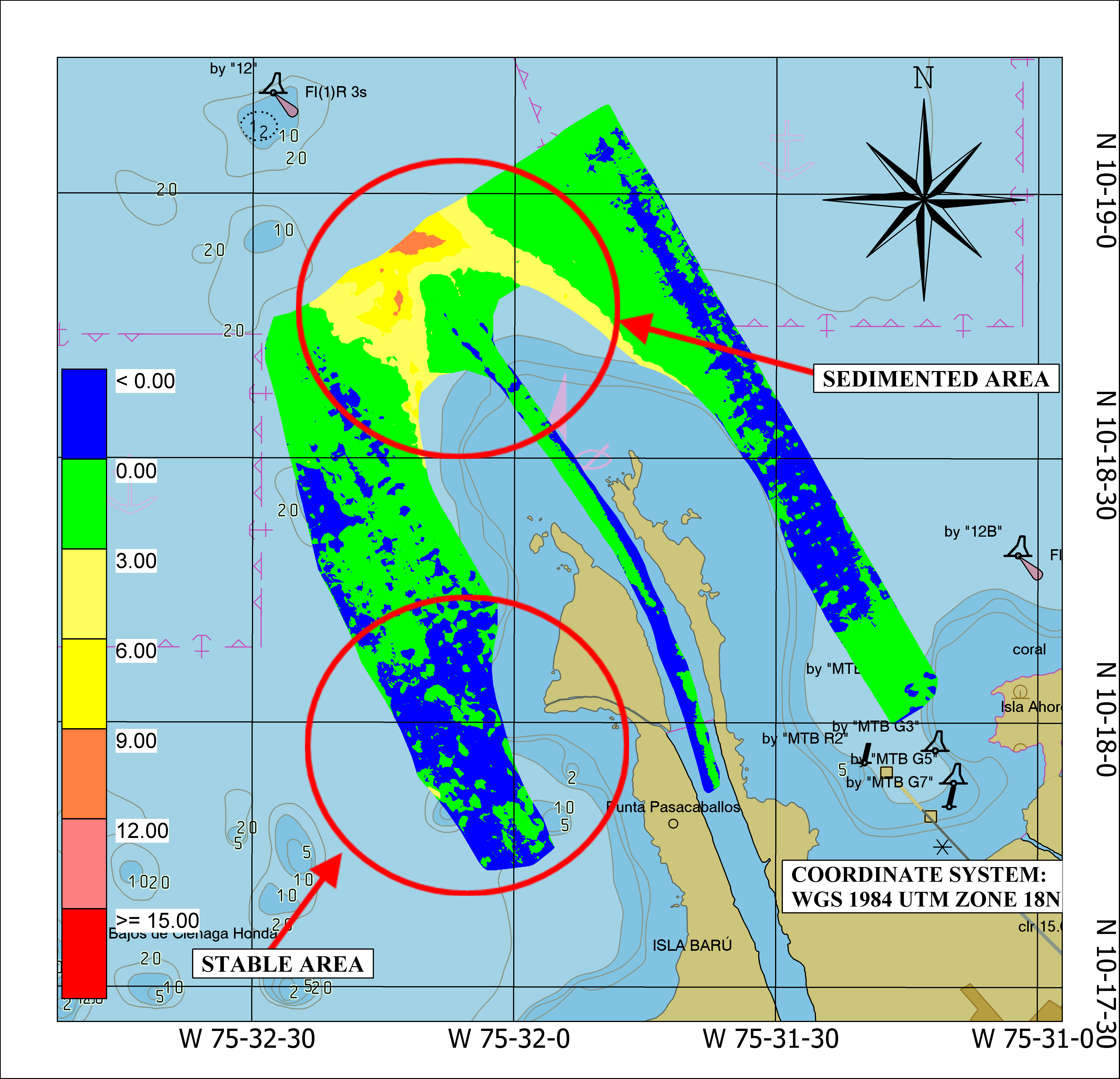
To perform the comparison of the change in the seabed configuration in the area, comparisons were conducted between the surfaces of hydrographic surveys from the same sector (Figs. 8 and 9).
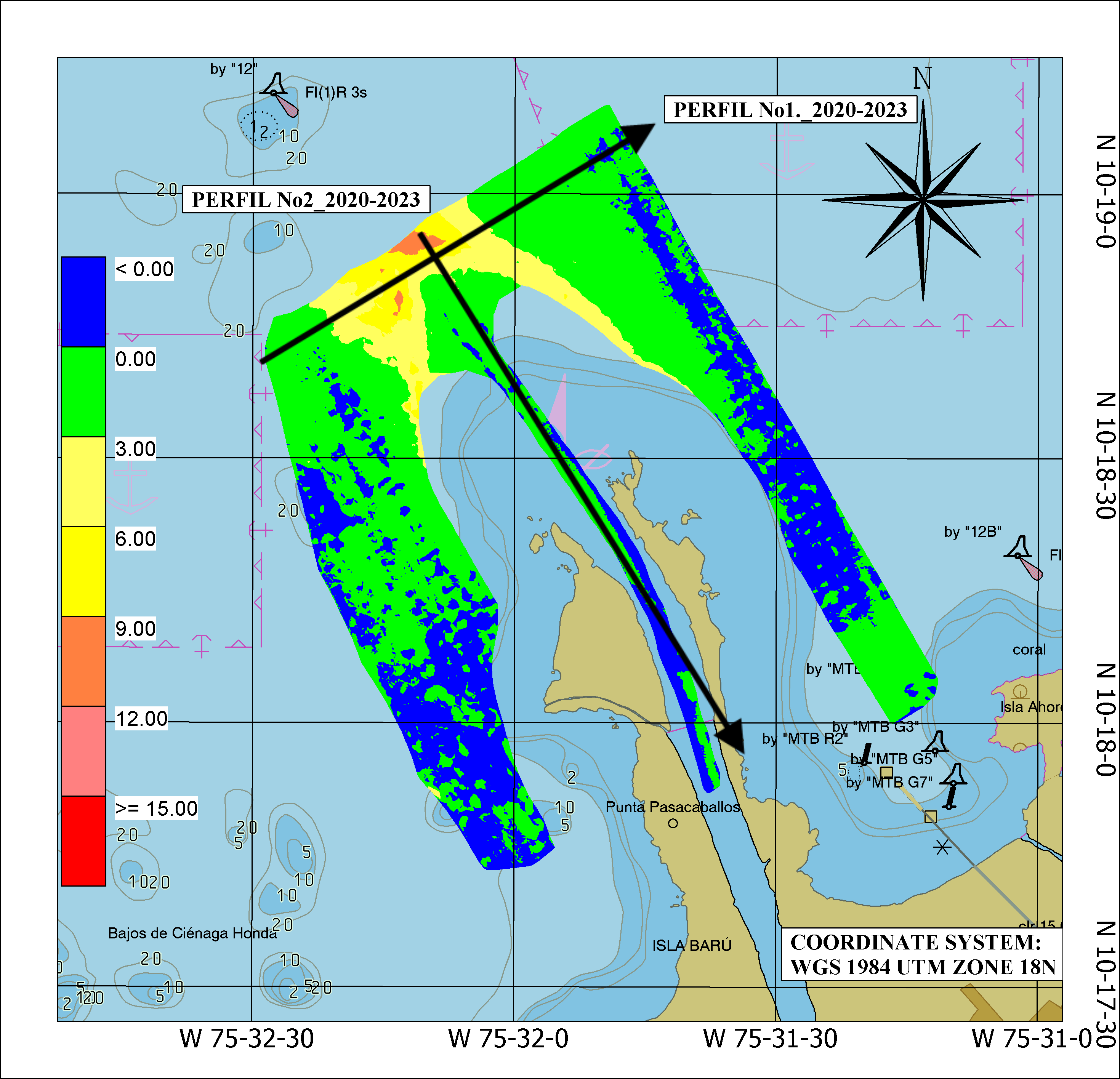
In Fig. 8, the areas of higher sedimentation in the sector over an 8-year period (2012–2020) are observed. The blue colors represent areas where depths have not undergone significant changes, while the red colors correspond to zones that have experienced greater changes due to sedimentation. Similarly, in Fig. 9, differences over a 3-year period (2020–2023) are depicted. By maintaining the same color scale, stable areas and sediment-affected zones can be clearly identified.
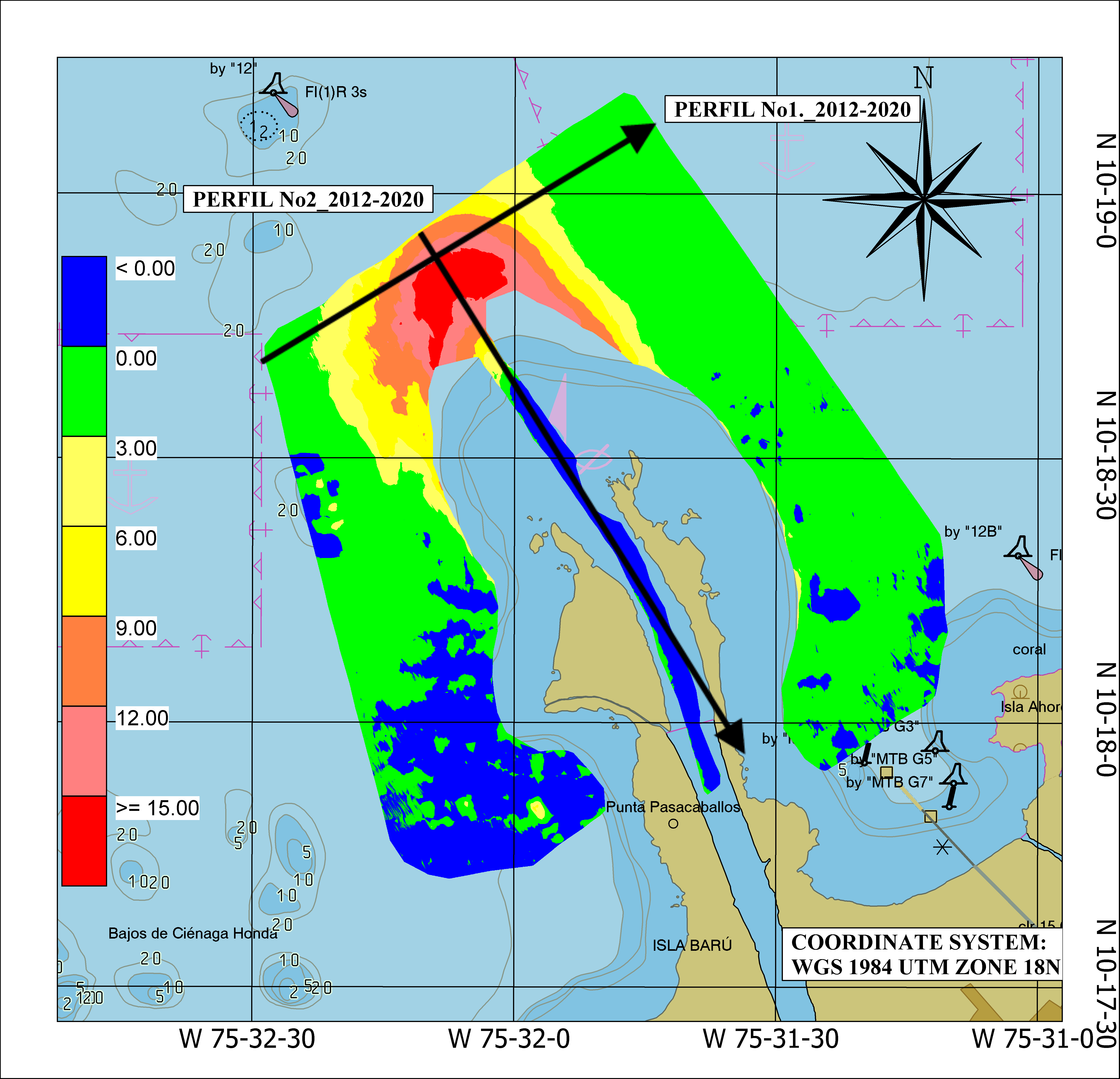
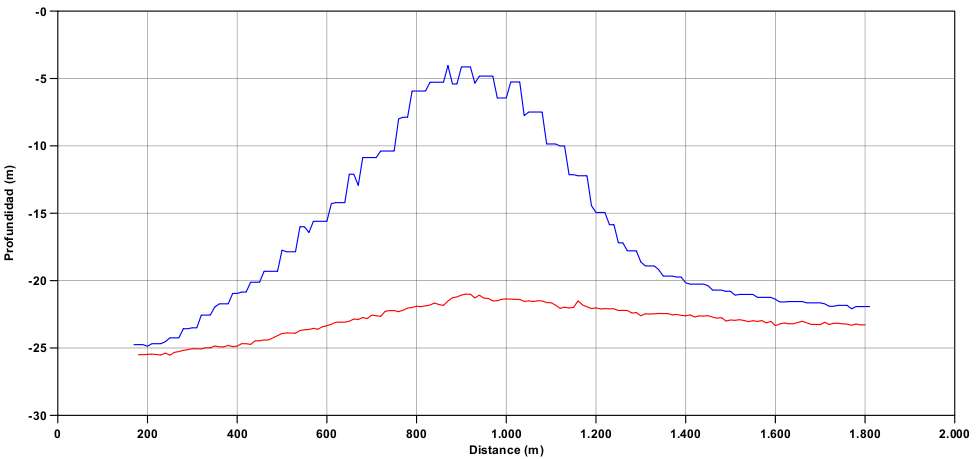
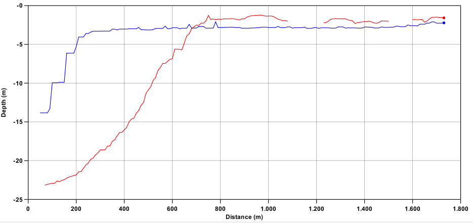
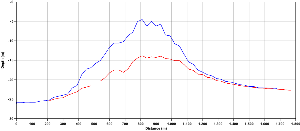
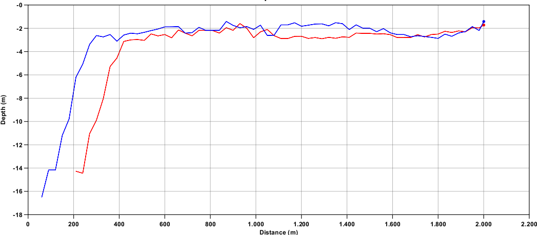
Longitudinal and transverse profiles were also conducted throughout the entire study area to perform depth comparison analyses among the different surveys (Figs. 10 and 13). This approach was undertaken to validate the significant changes in the seafloor geomorphology caused by sediment deposition resulting from the Dique Channel ‘s influence on the Bay of Cartagena over time.
In Figs. 11 and 12, the comparison of profiles between the surveys conducted in the years 2012 and 2020 can be observed. The red line represents the year 2012, while the blue line represents the survey conducted in the year 2020. Similarly, in Figs. 14 and 15, the respective profile comparisons between the hydrographic surveys of the years 2020 and 2023 are evident.
6 Analysis of the coastline
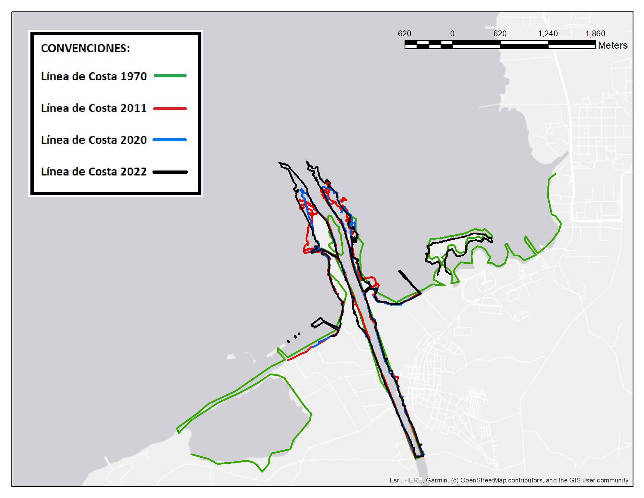
Using the Google Earth tool, the digitization of the coastlines at the mouth of the Dique Channel for the years 1970, 2011, 2020, and 2022 was carried out. These data were exported in *.kmz format and converted to *.shp using ESRI’s Geographic Information System software (ArcGIS), as shown in Fig. 16.
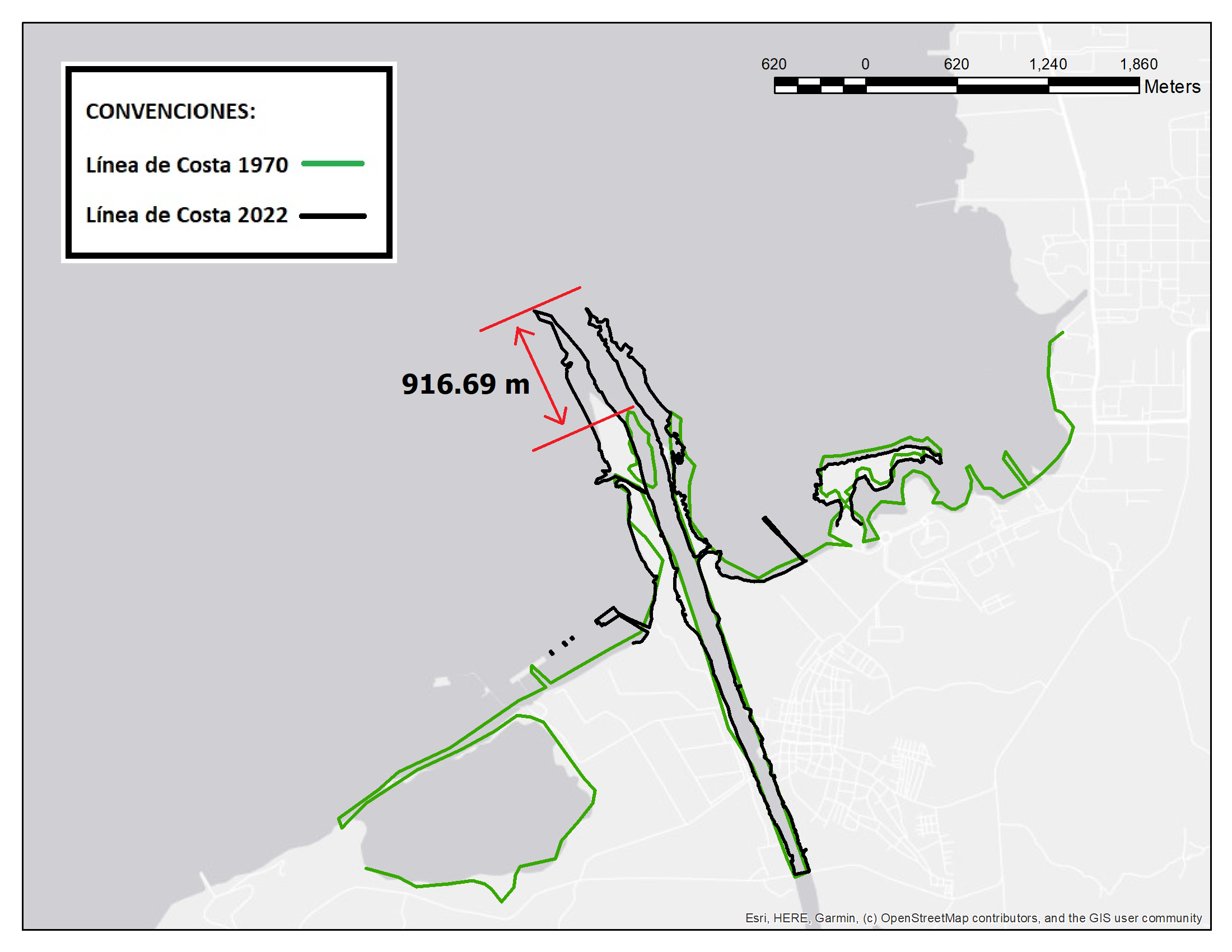
Using the multiyear shorelines, an analysis of the evolution of the coastal edge was performed, revealing that the shoreline has moved longitudinally 916.69 m towards the Bay of Cartagena between 1970 (green line) and 2022 (black line), evidencing the high sedimentation in this 52-year period. See Fig. 17 for reference.
7 Results
Between the hydrographic surveys of the years 2012 and 2020, it was observed that the 4-meter depth contour in the Bay of Cartagena shifted 420 m towards the 324° mark. Depths that were previously 21 m deep now measure 4 m. Similarly, between the surveys of the years 2020 and 2023, the 4-meter contour moved 200 m towards the inner part of the Bay of Cartagena at the 327° mark, leaving it only 800 m away from the navigable channel.
The depths found in the navigable river channel, once the multi-temporal comparisons were completed, remain between 2 m and 3 m deep.
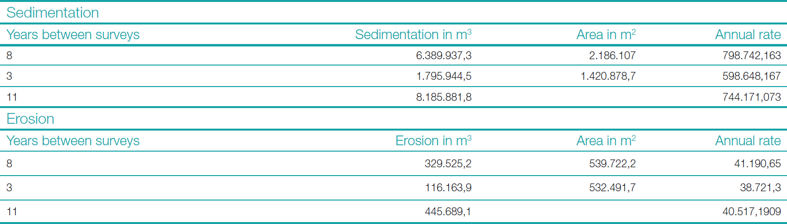
The volume calculation was conducted between the two surveys of the years 2012 and 2020, revealing that during this period, the study area experienced sedimentation of 6,389,937.3 m3 over an area of 2,186,107 m2, and erosion of 329,525.2 m3 over an area of 539,722.2 m2.
Similarly, the volume calculation was conducted between the two surveys of the years 2020 and 2023, revealing that the study area has undergone sedimentation of 1,795,944.5 m3 over an area of 1,420,878.7 m2, and erosion of 116,163.9 m3 over an area of 532,491.7 m2.

8 Conclusions
The multitemporal analysis carried out with the three hydrographic surveys during the years 2012, 2020, and 2023 at the mouth of the Dique Channel, allows us to identify a high sedimentation rate in the Bay of Cartagena (approximately 744,171.073 m3 annually), due to the influence of the Dique Channel. Over the years, considerable changes in the morphology of the seabed will occur, along with an annual erosion averaging around 40,517.2 m3. See Table 1 for details.
The contour velocity at a depth of 4 m advances significantly (from 52.5 m/year to 66.6 m/year). For more details, See Table 2.
The area of erosion recorded is relatively smaller compared to the sedimentation area (18 times less). These areas are located outside the Dique Channel, which does not contribute to safe navigation.
The coastline at the mouth of the Dique Channel has longitudinally shifted 916.69 m towards the Bay of Cartagena over a span of 52 years. See Fig. 17 for reference.
The displacement of the coastline is due to the sediments brought by the Dique Channel, causing erosion at its mouth in the same direction.
The sedimentation in the studied area poses a danger to navigation and challenges the management of the coastal zone.
9 Recommendations
Considering that the Dique Channel is a fork of the Magdalena River that flows into the Bay of Cartagena, therefore the flow is one of the most influential factors in the transport of sediments in the sector and taking into account that during the year there are different meteorological periods such as dry or wet seasons influenced sometimes by the El Niño or La Niña phenomena, where the flow of this river artery increases or decreases and directly proportional its contribution of sediment to the bay, it is necessary to carry out hydrographic surveys more frequently in this sector, in order to provide sedimentation and erosion values in shorter intervals, which would help the authorities to establish contingency measures to reduce the probability of accidents that mainly affect human life at sea, environmental conservation and the economic development of the country.
The advancement of the shallower depths towards the navigable channel of the Bay of Cartagena could be managed by continuous dredging, both in the Dique Channel and at its mouth.
Currently we do not have documented the number of dredging cycles performed in this sector, however it should be taken into account that performing operations that involve removing the seabed could increase toxicity and contamination due to the presence of metals such as Co, Cr, Cu, Ni, V and Zn, which show significant concentrations in the sediments of the Bay of Cartagena, attributed to the industrial zone of Mamonal and the Dique channel (Espinosa-Díaz et al., 2021)
Considering that in the study area there is a high traffic of tugboats with barges, it is recommended to install more navigation aids that clearly delimit the navigable channel for this type of vessel and in this way avoid maritime accidents due to grounding in the sector, in the same way take into account that it is a dynamic channel due to sedimentation, for this reason it is necessary to have updated bathymetry for the repositioning of floating navigation aids when required.
References
Espinosa-Díaz, L. F., Sanchez-Cabeza, J. A., Sericano, J. L., Parra, J. P., Ibarra-Gutierrez, K. P., Garay-Tinoco, J. A., Betancourt-Portela, J. M., Alonso-Hernandez, C., Ruiz-Fernandez, A. C., Quejido-Cabezas, A. and Diaz-Asencio, M. (2021). Registro sedimentario del impacto de las acciones de manejo sobre la contaminación de la bahía de Cartagena, Colombia. Marine pollution Bulletin, 172. https://doi.org/10.1016/j.marpolbul.2021.112807
IHO (2020). Standards for Hydrographic Surveys (6th ed.). IHO Special Publication S-44, International Hydrographic Organization, Monaco.
Ordoñez, J. I., Cubillos Peña, C. E. and Forero, G. (2007). Balance hídrico y sedimentológico del Dique Channel y sus efectos sobre la sedimentación de la Bahía de Cartagena. Third regional symposium in hydraulics on rivers, 18 pp. http://irh-fce.unse.edu.ar/Rios2007/index_archivos/C/6.pdf (accessed 17 February 2024).
Lonin, S., Parra, C., Andrade, C. and Thomas, Y. F. (2004). Patrones de la pluma turbia del Dique Channel en la Bahía de Cartagena. Bol. Cient. CIOH, 22, pp. 77–89. https://ojs.dimar.mil.co/index.oho/CIOH/article/view/130/87 (accessed 27 October 2024).
Tosic, M., Restrepo, J. D., Lonin, S., Izquierdo, A. and Martins, F. (2018). Water and sediment quality in Cartagena Bay, Colombia: Seasonal variability and potential impacts of pollution. Estuarine, Coastal and Shelf Science, 216, pp. 187–203. https://repository.eafit.edu.co/server/api/core/bitstreams/c1be59bf-7538-4f72-8f33-5ee393e2fa5d/content (accessed 27 October 2024).
Villanueva-García, E. P., Parra-León, N., Parodi Jaramillo, J. and Restrepo López, J. C. (2022). Caracterización sedimentológica y morfológica de la bahía de Cartagena (2000–2020). Bol. Cient CIOH, 41(1), pp. 33–47. https:// doi.org/10.26640/22159045.2022.587