


Abstract

1 Introduction
The history of the IHO-Nippon Foundation Geospatial Marine Analysis and Cartography (GEOMAC) project began in 2008 with the Japan Capacity Building Project (JCBP), which provided training courses to develop nautical cartographers. At that time, with the global push to publish Electronic Nautical Charts (ENCs), training technicians to produce and maintain up-to-date nautical charts was an international challenge. Therefore, the International Hydrographic Organization Secretariat (IHO Secretariat; then called the International Hydrographic Bureau: IHB) and the Japan Hydrographic Association (JHA), together with the United Kingdom Hydrographic Office (UKHO) and the Japan Hydrographic and Oceanographic Department (JHOD), launched the JCBP to train nautical cartographers of developing countries in a course internationally recognized as meeting the Standards of a Category “B”, particularly in Asia and the adjacent regions. The JCBP received financial support from the Nippon Foundation, a non-profit organisation established in Japan in 1962.
The IHO-Nippon Foundation Cartography, Hydrography and Related Training (CHART) project was launched in 2014 as a successor of the JCBP. The project, that continued to provide an international recognized course with the Category “B” for nautical cartographers, mainly from developing countries, was implemented by the IHO together with the UKHO and the JHOD, with the financial support of the Nippon Foundation.
In recent years, the number of IHO Member States has increased from 80 countries in 2009 to 100 countries in 2024, and the global demand for training nautical cartographers is even stronger. In addition, IHO Member States are also expected to respond to the digital age, including the processing and management of large volumes of bathymetric data, the creation of next-generation S-100 products, and uncrewed vessels.
To address these challenges in terms of navigational charts, the IHO-Nippon Foundation GEOMAC project was launched in 2020 as a successor to the CHART project by the IHO together with the UKHO and the JHOD, with the financial support of the Nippon Foundation. The GEOMAC project is currently providing the 16th training course in 2024.
In this paper, Section 2 reviews the evolution of the project management basically from 2008 to 2023. Section 3 describes the current training course of the GEOMAC project, Section 4 introduces the Alumni Seminars, and Section 5 discusses the achievements. Section 6 provides a summary and future perspectives.
2 Change in the project management
2.1 Management system
To implement the JCBP, the IHB signed a Memorandum of Understanding (MoU) with the JHA (acting on behalf of the JHOD) in October 2008, valid until 2013. As stated in the IHO CL 77/2008 (IHO, 2008), the Nippon Foundation supported the project financially, the IHB implemented and managed the project in consultation with the JHA, and the UKHO was selected as the training provider for the nautical cartographer courses internationally recognized with the Category “B”.
In December 2013, a new MoU was established between the IHO and the Nippon Foundation, as stated in the IHO CL 10/2014 (IHO, 2014). The purpose of the MoU was to provide the overarching framework for the continuation of discussion and consultation between the two parties in relation to enhancing human relations, capacity building, and awareness of the need to survey and map the world’s seas, oceans and coastal waters and other matters of mutual interest.
In accordance with the purpose of the MoU, a three-year capacity building project, the IHO-Nippon Foundation CHART project, was proposed by the IHB to the Nippon Foundation and started in 2014 following approval. The management framework of the CHART project gave IHB responsibility for the implementation and management of the project, which had previously been the undertaken by the JHA. However, the financial and delivery system was continued, with the Nippon Foundation providing financial support and the UKHO providing the training course.
This management system has been continued in the IHO-Nippon Foundation GEOMAC project, launched in 2020, where the Nippon Foundation provides financial support for the project, the IHO Secretariat implements and manages the project, and the UKHO provides the training of the “Geospatial Marine Analysis and Cartography” course for nautical cartographers, which is recognised as Category “B” by the FIG-IHO-ICA International Board of Standards of Competence for Hydrographic Surveyors and Nautical Cartographers (IBSC).
2.2 Budget
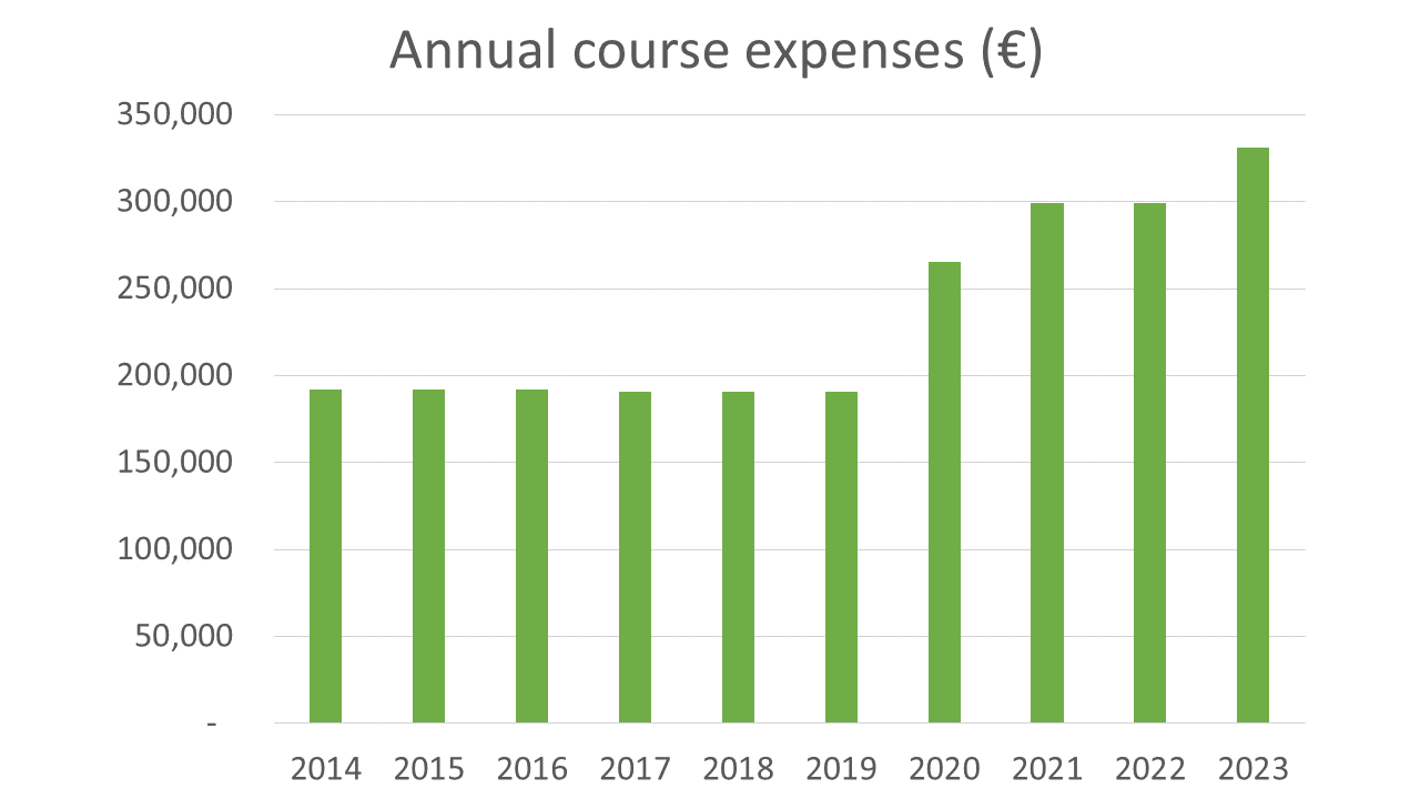
The annual budget for the implementation of training courses from the CHART project in 2014 to the GEOMAC project in 2023 is shown in Fig. 2. This budget includes the course fee, travel expenses and per diem for the students. The budget was initially around 200 000 €/year, but now exceeds 300 000 €/year due to the longer training periods mainly associated with the introduction of new modules for more advanced training in the GEOMAC project.
The budget from the Nippon Foundation is one of the most generous and significant contributions to the Capacity Building Fund to support the IHO Capacity Building Programme, as reported in the Finance Report of the 21st Capacity Building Sub-Committee Meeting (IHO, 2023a).
2.3 Objectives and expected outcomes
The project focuses on two key objectives currently facing the world of hydrography:
To drastically reduce the existing gap between countries in terms of their capacity to comply with their obligations and responsibilities as sovereign states, as mandated by international instruments such as the SOLAS and UNCLOS conventions.
To prepare hydrographers and nautical cartographers for the ever-increasing technological developments, ensuring the maximum societal gain in the blue economy and social achievements in a sustainable way, while preserving the safety of navigation.
In order to continue to meet these objectives, the current GEOMAC project expects students who complete the training course to be able to:
Be involved as a nautical cartographer in their organizations and improve the capacity, the quality and usefulness of electronic and paper nautical charts and hydrographic services of their countries.
Take a leading role in guiding the organization to adapt to the ongoing and future digital innovations such as IHO S-100 framework, Maritime Spatial Data Infrastructures (MSDI), Digital Twins and uncrewed vessels.
Share the knowledge gained with their colleagues in their Hydrographic Offices and contribute to the strengthening of cooperation between alumni; and
Engage in and support international cooperation projects, including but not limited to the Nippon Foundation-GEBCO Seabed 2030 project, and play a leading role in their respective regions.
2.4 Application
Following the yearly IHO Circular Letter calling for nominations, each IHO Member State has been able to nominate one suitable candidate for the training course at the UKHO.
In accordance with the IHO Capacity Building Strategy (IHO, 2021), this training course is open only to candidates from IHO Member States who are employed by a hydrographic office, a port authority or a related national agency of the nominating country. Also, the national authority nominating candidates should confirm that appropriate opportunities will be in place for the individual to apply the knowledge on their return for the maximum benefit and that they meet the prerequisite criteria for attending the Category “B” course.
2.5 Selection
The selection process in the recent years has started with a Coordination meeting between the IHO Secretariat, UKHO and JHOD. At this meeting, the selection criteria and the annual plan for the implementation of the training course are discussed.
For example, for the GEOMAC training course in 2023, as stated in the IHO CL 09/2023 (IHO, 2023b), nominated candidates must meet the following criteria:
A very good standard of English, both written and spoken, with reasonable technical English.
A high standard in mathematics and geography.
A background in cartography, hydrographic surveying, geospatial sciences or related areas.
Individual commitment for international cooperative activities such as Seabed 2030.
A Selection Panel meeting between the IHO Secretariat, UKHO and JHOD carefully reviews all applications, and the IHO Secretariat and the Nippon Foundation make the final selection of the candidates for the training course. An IHO Circular Letter then issued to announce the successful nomination of candidates and individual notification letters are also sent to each candidate’s organisation.
2.6 Timeline by project period
2.6.1 JCBP (2008–2013)
The main events in the JCBP from 2008 to 2013 are summarised in Table 1.
This project was originally scheduled to end in March 2013, but due to huge demands for the training and generous support from the Nippon Foundation, it was continued for another year.

2.6.2 CHART project (2014–2016)
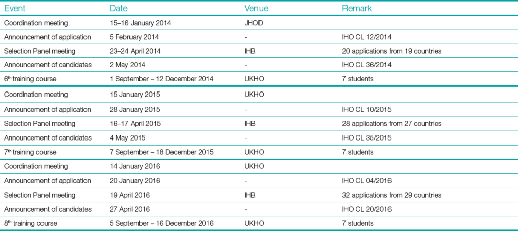
The main events in the CHART project from 2014 to 2016 are summarised in Table 2.
2.6.3 CHART project (2017–2019)
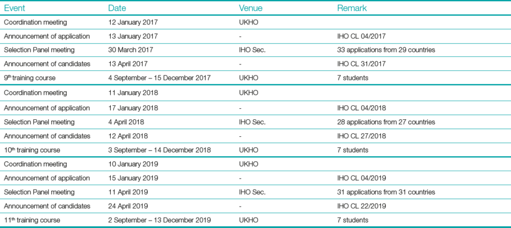
The main events in the CHART project from 2017 to 2019 are summarised in Table 3.
2.6.4 GEOMAC project (2020–2022)
The main events in the GEOMAC project from 2020 to 2022 are summarised in Table 4.
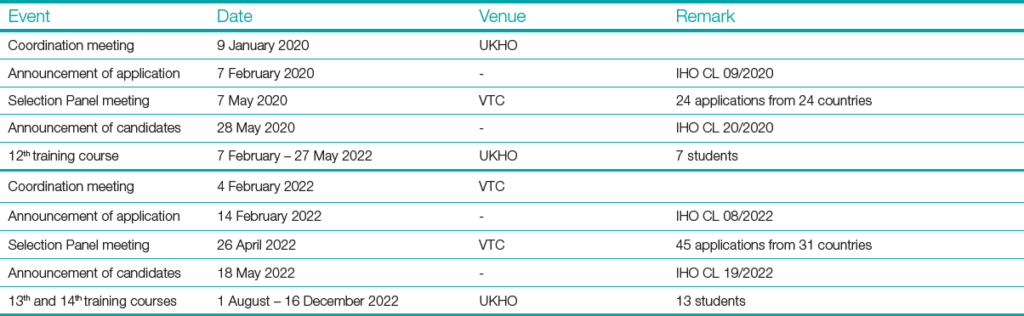
With the spread of the COVID-19 pandemic, the 12th training course was provisionally scheduled from 1 September to 18 December 2020. However, given the lack of improvement in the pandemic situation and the paramount importance of ensuring the safety of all people involved in the training course, the IHO Secretariat, in close contact with the Nippon Foundation and the UKHO, decided to postpone the first time in July 2020, the second time in February 2021 (IHO CL 08/2021) and the third time in August 2021 (IHO CL 31/2021). After overcoming these difficulties, the 12th course was successfully held from 7 February to 27 May 2022.
At the same time, preparations were made for the next training courses. Due to the delay of the 12th training course, impacting the scheduling of the 13th training course, it was agreed to hold both the 13th and 14th course at the same time. The 13th and 14th training courses were held from 1 August to 16 December 2022.
2.6.5 GEOMAC project (2023–2025, in progress)
The main events in the GEOMAC project from 2023 to 2024 (ongoing) are summarised in Table 5. This project will be continued until 2025.

3 Training course
3.1 Evolution of course content
The evolution of the content of the training courses from the JCBP to the GEOMAC project is shown in Fig. 3. Each training course consists of several modules and meets the IHO S-8B Standards of Competence for Category “B” Nautical Cartographers. In addition, the training course has been enhanced to take into account the issues that nautical cartographers currently face/will face with the rapid innovations of modern technology.

3.2 Current course content
The current training course consists of seven modules (“Distance Learning Module”, “Foundation Module”, “Geospatial Fundamentals Module”, “Compilation Module”, “Product Construction Module”, “Data Assessment and Product Maintenance Module” and “Final Project”), which are recognised as a Category “B” accredited course, and two modules (“Cooperation Module” and “Digital Twin & S-100 Implementation Module”), which are focus on the wider use of data and the future realm of nautical cartography beyond Category “B” course.
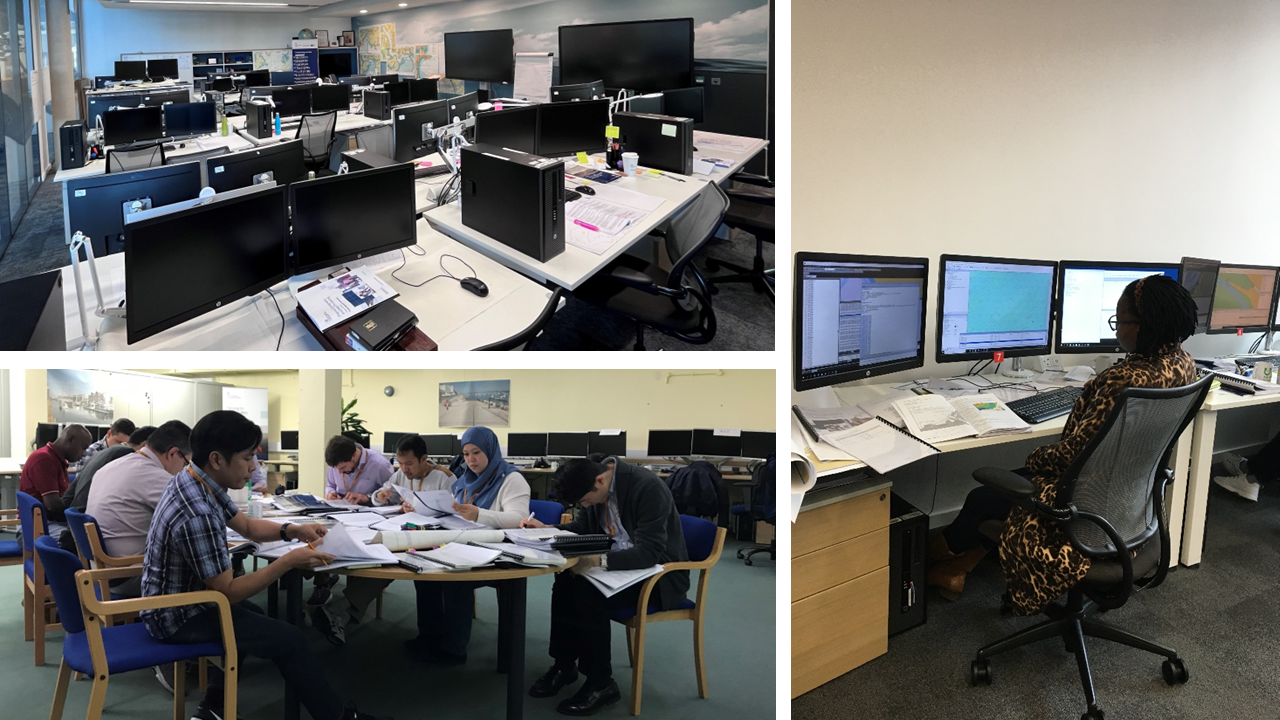
The Category “B” course content and Digital Twin and S-100 Implementation Module are delivered by the UKHO training team (as shown in Fig. 4), supplemented by presentations given by UKHO specialist speakers and visits to relevant UKHO work areas. The Cooperation Module is provided by OceanWise and Map the Gaps.
In addition, as shown in Fig. 5, field trips are undertaken to enrich the class-based training for the students to understand nautical chart use, data collection, national and port responsibilities.
During the course the IHO Secretariat staff visit the UKHO, as shown in Fig. 6, to give presentations to the students on the roles and responsibilities of the IHO and to reinforce their understanding the importance of international cooperation.


Students are formally assessed throughout the course through tests and assignments undertaken at the end of each module and must meet or exceed the standard. Ongoing feedback is given to students to help them develop and prepare for the formal assessments. An overall assessment is made of each student and feedback is given at the end of the course. A certificate stating successful completion of the Category “B” course is awarded to all those who complete the training course satisfactorily.
The training course is fully evaluated by the students both during and at the end of the course. All students are requested to provide feedback to their training team on their learning progress and any issues they may have, giving them direct input into their own learning and helping to resolve any issues. They are also requested to complete a final evaluation to review the whole training programme.
Alongside the training course, the training team organise weekend excursions to sites of local interest, and a number of social events allowing students to socialise in an informal atmosphere and contribute to a stronger network.
4 Alumni seminar
The IHO-Nippon Foundation Alumni Seminars are held to strengthen the alumni network, promote cooperation among alumni, enhance global friendship and receive feedback from alumni on the impact of the respective courses to them, to their organizations and their countries.
The first alumni seminar (then called workshop) was held in Bangkok, Thailand from 2 to 4 November 2016, and the second in Singapore from 29 to 31 October 2019.
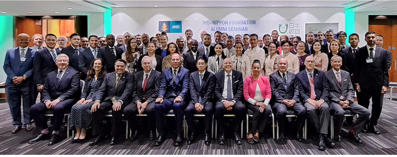
Most recently, the third alumni seminar was held in London, UK from 25 to 27 October 2023 (Fig. 7). This alumni seminar was attended by 48 alumni from 32 countries, 16 invited guest speakers and others, such as the Executive Director of the Nippon Foundation, the UK National Hydrographer, the IHO Director, the FIG President, IBSC Members and the Director of the Nippon Foundation-GEBCO Seabed 2030. The guest speakers presented on a wide range of topics including the vital role of nautical cartographers, the challenges within the maritime environment and digitalisation.
During the seminar, the alumni participants had a group work to strengthen the alumni networking. The alumni were divided into several groups with different countries of origin and different training years, and each group discussed ocean-related topics such as the use of chart data, the S-100 world, and the AI-era, concluding with a short presentation.
Throughout the seminar, alumni learned about the latest technological developments in their related field and actively shared their experiences, recent achievements and best practices.
Based on some of the input received in the alumni seminar in 2019, a LinkedIn group page for the alumni was launched in 2019. By the end of 2023, more than 50 alumni had joined this group. The group page is expected to be a platform to share specific and practical information and to communicate with each other beyond the alumni year.
5 Achievement
The most significant achievement of the JCBP/CHART/GEOMAC project is the worldwide active network of the IHO-Nippon Foundation alumni, one of the largest communities of nautical cartographers. The number of alumni has been steadily increasing and at the end of 2023 there were 99 alumni from 51 countries, as shown in Fig. 8. The alumni list and distribution are available on the website at https://iho.int/en/alumni-list-and-distribution.
Many alumni have actively participated in many IHO related meetings representing their organisations and nations. At the regional level, some alumni have participated in meetings of Regional Hydrographic Commissions (RHCs) as leading cartographers in their offices. At the international level, some alumni have been involved in working with the Regional ENC Coordinating Centres (RENCs) as well as in the IHO technical meetings.
The statistics based on the IHO Publication C-55 “Status of Hydrographic Surveying and Nautical Charting Worldwide” show that alumni countries have made better progress than non-alumni countries in terms of the world nautical charting coverage. In the technical document CBSC17-08.4B of the 17th meeting of the IHO Capacity Building Sub-Committee (IHO, 2019), the average increase in the total sum of charting coverage from 2014 to 2019 is 41 points for alumni countries and 17 points for non-alumni countries. In the recent statistics, the average increase in the total sum of charting coverage from 2019 to 2023 is 20 points for alumni countries and 5 points for non-alumni countries.

6 Conclusion
Since the start of the JCBP in 2008, through the CHART and GEOMAC projects, the number of alumni of these projects is approaching 100 in over 50 countries. They are active in a wide range of national, regional and international stages, and their efforts are contributing to the quality and acceleration the nautical charting coverage worldwide.
The project has continuously improved its training content, budget and management system to ensure that it adapted to cover the evolution on the skills required by nautical cartographers of all eras, as well as the rapidly developing advanced technologies of recent years. These efforts have made the GEOMAC project one of the greatest success stories of the IHO Capacity Building Programme.
This GEOMAC project is open to the IHO Member States and the IHO Secretariat expects their positive applications and participation. Up-to-date information on the GEOMAC project can be found in the IHO Circular Letters and on the IHO website at https://iho.int/en/iho-nf-geomac-project.
Acknowledgements
The authors would like to express their great appreciation to the Nippon Foundation, which has provided significant financial support for the project and has worked together to improve the project through many constructive exchanges of views on the revisions of the course based on the prospects for the next era. Special thanks are extended to Mr Unno, Executive Director of the Nippon Foundation, for his various forms of support, including his participation in the alumni seminars.
The authors would like to thank the UKHO for providing the training courses for the project. Special thanks are due to the current UKHO training team, support staff and to Mr Bryant, who has been
involved in this training for many years.
The authors would like to thank the IHO responsible for the management of this project. Special thanks are due to Mr Nakabayashi, Mr Yamao, Dr Kaneda and Mr Nagasaka, the Japanese secondments at the IHO.
Finally, the authors would like to thank the JHOD and JHA for their support of the project since its inception.
References
IHO (2008). Japan capacity building project and secondment of personnel. IHO Circular Letter 77/2008, International Hydrographic Organization, Monaco. https://legacy.iho.int/mtg_docs/circular_letters/english/2008/Cl77e.pdf (accessed 16 October 2024).
IHO (2014). Signing of the Memorandum of Understanding between the International Hydrographic Organization and the Nippon Foundation. IHO Circular Letter 10/2014, International Hydrographic Organization, Monaco. https://legacy.iho.int/mtg_docs/circular_letters/english/2014/Cl10e.pdf (accessed 16 October 2024).
IHO (2019). A quantitative analysis of a capacity building activity, the IHO-Nippon Foundation CHART project. CBSC17-08.4B, 17th Meeting of the IHO Capacity Building Sub-Committee IHO-CBSC17, Genoa, Italy, 29–31 May 2019. https://legacy.iho.int/mtg_docs/com_wg/CBC/CBSC17/CBSC17-08.4B_2019_EN_CHART_project_analysis_v1.pdf (accessed 16 October 2024).
IHO (2021). IHO Capacity Building Strategy. International Hydrographic Organization, Monaco. https://iho.int/uploads/user/Inter-Regional%20Coordination/CBSC/MISC/Capacity_Building_Strategy_2021_ver05.pdf (accessed 16 October 2024).
IHO (2023a). Finance Report. CBSC21-09.2, 21st IHO Capacity Building Sub-Committee Meeting, Tokyo, Japan 7–9 June 2023. https://iho.int/uploads/user/Inter-Regional%20Coordination/CBSC/CBSC21/CBSC21-09.2_EN_CB_Finance_Report_v1.pdf (accessed 16 October 2024).
IHO (2023b). Call for Applications to the IHO – Nippon Foundation, Geospatial Marine Analysis and Cartography (GEOMAC) Project, UKHO Taunton UK. IHO Circular Letter 09/2023, International Hydrographic Organization, Monaco. https://iho.int/uploads/user/circular_letters/eng_2023/CL09_2023_EN_v1.pdf (accessed 16 October 2024).