
Abstract
Preamble
The following work was presented at the 12th ABLOS Conference, 7–8 October 2025, Doha, Qatar in the oral session Ocean observation and cooperation frameworks.
1 Introduction
Marine megafauna such as whales and penguins play critical ecological roles and hold cultural, economic, and conservation significance across the world’s oceans. Yet despite decades of commitments under the United Nations Convention on the Law of the Sea (UNCLOS) to protect and preserve the marine environment, the effectiveness of protection measures remains uneven (UN, 1982). UNCLOS establishes a comprehensive legal framework for the oceans, but it does not prescribe how States should integrate rapidly evolving observation technologies into day-to-day management. As ocean uses intensify and biodiversity loss accelerates, the absence of interoperable ecological data standards presents a structural governance risk, not merely a technical challenge.
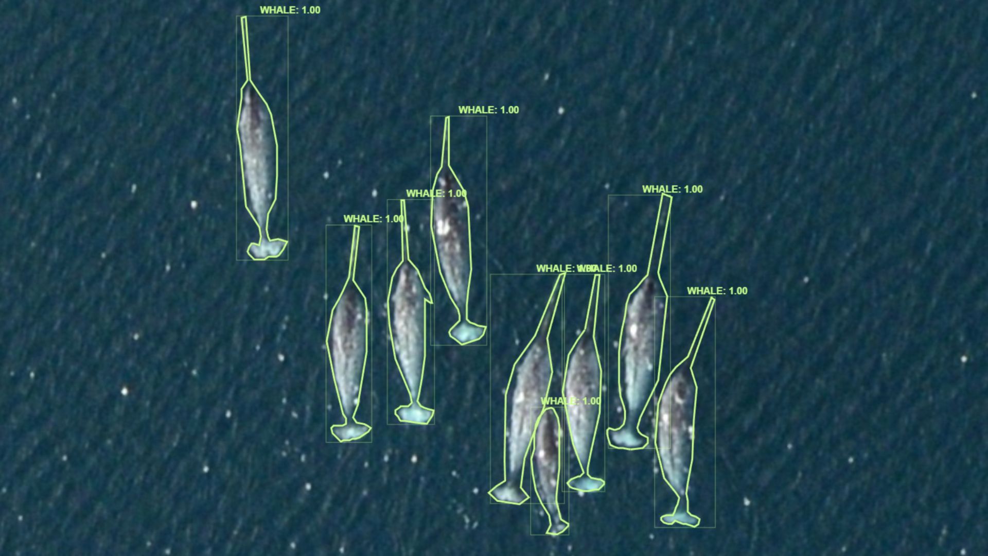
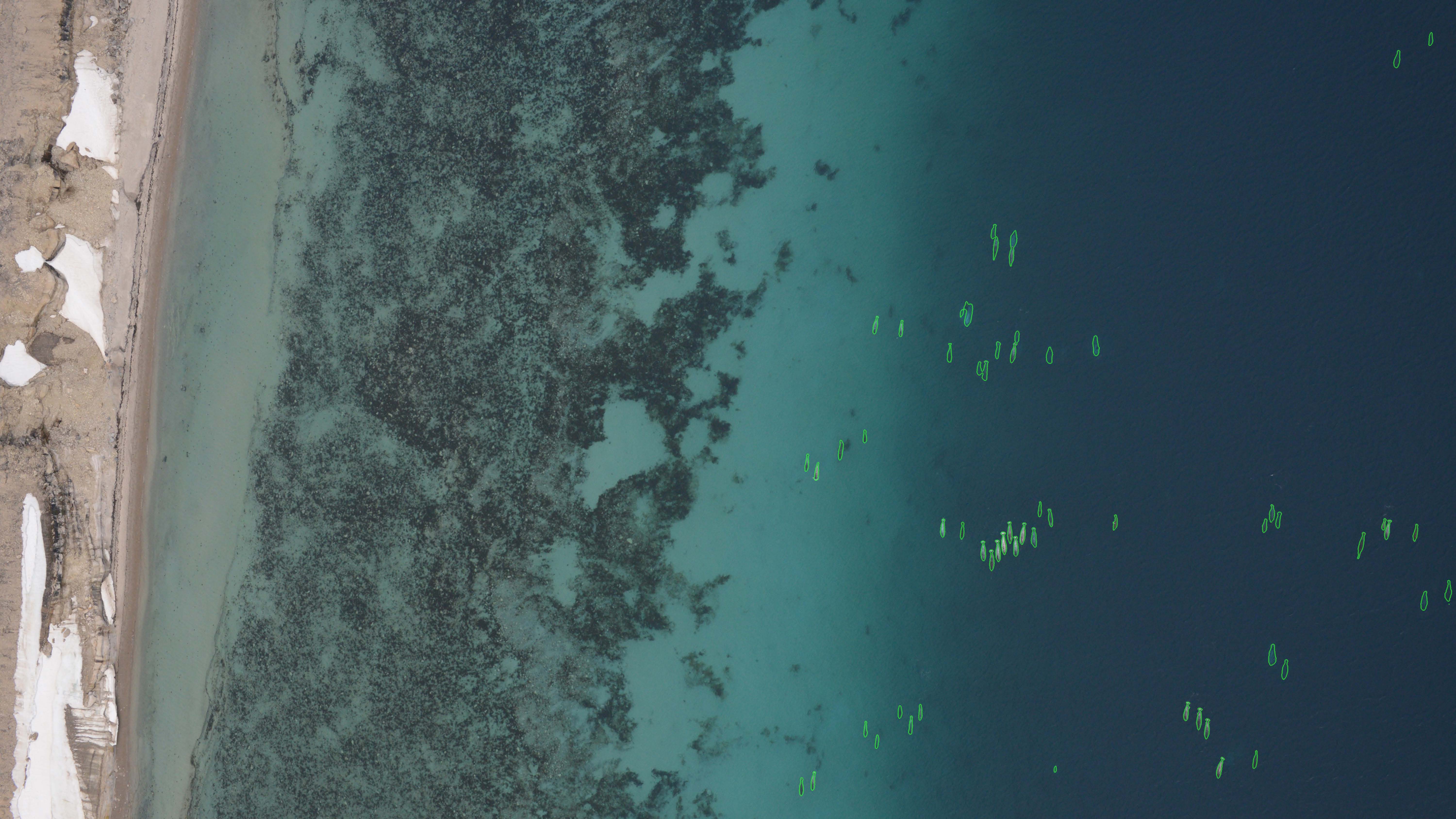
Today’s observation landscape spans satellite platforms capable of wide-area monitoring, uncrewed aerial systems (UAS) that provide high-resolution local imagery, automated detection powered by artificial intelligence (AI), and acoustic platforms that complement visual datasets. These tools enable the detection of individual animals (Figs. 1 and 2), the mapping of colonies, and the characterization of habitats at spatial and temporal scales unimaginable when UNCLOS was adopted (Seymour et al., 2017; Fretwell & Trathan, 2021). The challenge is integrating these capabilities into institutional frameworks not designed for rapid, data-intensive ecological monitoring.
This Note draws on three applied case studies from work conducted by Whale Seeker and partners:
- Dynamic vessel management in Canada’s EEZ, where AI-assisted UAS detection increased the identification of endangered North Atlantic right whales compared with an AI that had no domain specific expertise.
- Penguin and habitat monitoring in Antarctica, where drone imagery and AI revealed both new ecological insights and persistent gaps in Antarctic Treaty-era data-sharing practices.
- Satellite-based whale migration analysis, undertaken with WWF, Fisheries and Oceans Canada, Princeton University, and others, illustrating the challenges of monitoring beyond jurisdictional borders.
Across these examples, a consistent pattern emerges: the technical capacity to observe marine megafauna exists, but the pathways to integrate, share, and govern these data are insufficiently developed. High-resolution imagery remains costly; open data sources are powerful for climate applications but too coarse for individual animals; and operational deployment is constrained by weather, permitting, and the lack of interoperable data pipelines.
To address this gap, the Note considers near-term, practical opportunities for strengthening marine megafauna protection by improving interoperability and data equity. In particular, it explores how biodiversity information could be integrated into the International Hydrographic Organization’s S-100 framework, a global geospatial standard already used for navigation and ocean data products (IHO, 2022). An S-100-compatible biodiversity layer would provide a consistent foundation for science, planning, and adaptive management across jurisdictional boundaries.
2 The technological landscape
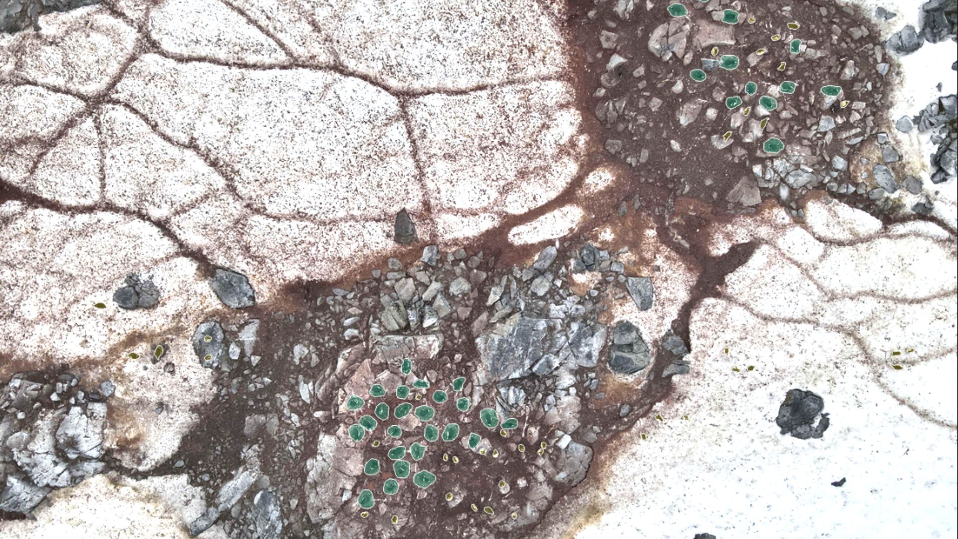
Modern ocean observation rests on a diverse set of complementary tools that operate across spatial and temporal scales. Satellites provide wide-area coverage suitable for identifying environmental conditions, surface features, and, in some cases, large marine animals. Very-high-resolution sensors can detect individual whales or penguin colonies in remote regions, extending monitoring to areas that are logistically difficult to access (Fretwell & Trathan, 2021). UAS supply high-resolution imagery capable of detecting individual whales, seals (Fig. 3), or seabird nests with exceptional precision, while minimizing disturbance and human risk (Seymour et al., 2017).
Automated AI models accelerate the analysis of these datasets, enabling near real-time detection, species identification, and habitat classification. These approaches are increasingly recognized as key components of “big data” frameworks for marine megafauna conservation, where large volumes of spatial information are used to understand movement, distribution, and threats at scale (Bax et al., 2019; Canonico et al., 2019). Acoustic platforms, though not the focus of this Note, contribute essential information in low-visibility conditions and complement visual data streams.
Individually, each modality offers unique strengths; together, they enable a multi-scale, multi-sensor approach suited to the detection and monitoring of marine megafauna. This integration is especially valuable for species that move across jurisdictional boundaries or inhabit remote regions where traditional surveys are challenging. For example, UAS can document fine-scale behaviours or distribution patterns, while satellites can simultaneously track environmental drivers influencing those movements on regional or basin scales.
Despite this technical maturity, operationalizing these tools within existing governance frameworks remains difficult. Weather, permitting requirements, data-processing logistics, and variable institutional capacity can limit the deployment of even the most sophisticated systems. In addition, cloud computing and AI validation require sustained investment, and high-resolution commercial imagery remains expensive, creating an uneven landscape in which well-resourced organizations can access advanced monitoring while smaller institutions, NGOs, and developing States may struggle (GOOS, 2025). The technological foundation for large-scale, consistent marine megafauna monitoring already exists; the remaining challenges lie in building the standards, data-sharing practices, and governance pathways needed to translate these capabilities into equitable and effective protection.

3 Case studies
3.1 Dynamic vessel management in Canada’s EEZ
North Atlantic right whales are among the world’s most endangered marine mammals, and vessel strikes remain one of the primary threats to their recovery. To support adaptive management in Canadian waters, Whale Seeker collaborated with Transport Canada and Innovation, Science and Economic Development Canada to deploy AI-powered detection tools within dynamic management zones.
Using UAS imagery processed through domain-informed datasets and standardized annotation protocols, the system improved whale detection performance, underscoring the importance of expert-curated training data in AI-enabled conservation applications (Seymour et al., 2017; Smit et al., 2022).
Improved detection can translate directly into more responsive vessel-speed restrictions and fishing-gear adjustments at finer spatial and temporal scales, aligning with the broader principles of dynamic ocean management, in which management measures respond in near real time to changing conditions (Maxwell et al., 2015). Expanding similar systems across Canada’s EEZ would strengthen adaptive management and help fulfil national obligations under UNCLOS to protect and preserve the marine environment.
3.2 Antarctica: penguins, pathogens, and the open-data paradox
The Antarctic Treaty System promotes the free exchange of scientific data, positioning Antarctica as a global common for research. Yet, in practice, access to ecological datasets is often fragmented, restricted, or dependent on institutional gatekeeping. Working with Oceanites, the only charity organization providing open, long-term data on penguin colonies in Antarctica, Whale Seeker applied UAS imagery and AI models to monitor penguin colonies and habitat conditions.
These tools enabled high-accuracy detection of penguins, nests, and land-cover classes across hundreds of hectares of surveyed terrain, supporting improved assessments of colony health and potential vulnerability to emergent threats such as avian influenza. This experience is consistent with broader trends in polar wildlife research, where satellite and UAS datasets are increasingly used to discover new colonies and assess population responses to sea-ice change (Fretwell & Trathan, 2021).
However, the project also highlights persistent tension between the Treaty’s open-data principles and the realities of scientific practice. While organizations such as Oceanites exemplify transparent and accessible data stewardship, many datasets remain siloed or available only to specific delegates or institutions. As climate change accelerates ecological pressures in Antarctica, broadening access to high-quality spatial data will be essential for informed management and global scientific collaboration (Bax et al., 2019).
3.3 Monitoring beyond borders: satellite-based whale migration analysis
Marine megafauna routinely traverse multiple EEZs and areas beyond national jurisdiction, making consistent monitoring a transboundary challenge. In collaboration with WWF, Fisheries and Oceans Canada, Princeton University, and other partners, Whale Seeker explored the use of high-resolution satellite imagery and AI to detect whales and infer migration timing and routes.
This work demonstrates both the promise and the constraints of satellite-based monitoring for wide-ranging species. While the imagery can reveal large-scale movement patterns, its utility is diminished by the fragmented nature of megafauna-related datasets. Information collected by governments, NGOs, private industry, and research institutions is often stored in incompatible formats or unavailable beyond project boundaries.
The satellite pilot underscores the need for interoperability: without standardized formats and pathways for sharing spatial biodiversity information, the full value of emerging remote-sensing technologies cannot be realized. Migratory species will continue to move across jurisdictions, but monitoring systems, and the governance frameworks they support, must evolve to match that scale (Bax et al., 2019; Smit et al., 2022).
4 Challenges in implementation and data equity
Although modern remote-sensing tools are technically mature, several operational and structural barriers constrain their deployment at scale. Technology readiness does not automatically translate into effective protection; real-world outcomes depend on weather, permitting, data infrastructure, and unequal access to resources.
4.1 Operational constraints
Practical challenges can significantly delay or limit monitoring campaigns. Weather affects UAS flights and satellite visibility windows. Regulatory approvals for drone operations or wildlife surveys often take longer than the ecological windows during which information is most needed. Even when data are collected, integrating imagery, annotations, and detections into management workflows requires robust pipelines that many agencies do not yet have (UNESCO/IOC, 2023).
These obstacles reduce the responsiveness of marine mammal monitoring during critical periods such as migration, breeding, or heightened industrial activity.
4.2 Fragmented data and governance
Across all three case studies, a core limitation was not the ability to observe marine megafauna, but the difficulty of integrating and sharing the resulting data. Observations from satellites, drones, government surveys, NGOs, and private operators are typically stored in incompatible formats and seldom combined. Without interoperable standards, decision-makers lack the unified view needed for adaptive management.
This fragmentation is particularly problematic for migratory species whose ranges span multiple jurisdictions. When each entity collects data independently, with different methodologies, taxonomies, temporal scales, or access rules, the collective value of these observations is diminished (Bax et al., 2019).
4.3 The risk of a two-tier monitoring system
The economics of marine monitoring amplify inequities. High-resolution commercial imagery remains costly, particularly for small island States, Indigenous communities, and under-resourced NGOs. Open satellite data, such as from Sentinel, are transformative for climate and oceanography but too coarse to detect individual whales or small seabird colonies. AI and cloud computing require ongoing investment that many organizations cannot sustain.
Recent analyses of global ocean data systems emphasize that the ocean remains under-observed, especially in developing regions, and that data are often fragmented and hard to access (GOOS, 2025). These conditions risk producing a two-tier system: wealthy States, research institutions, and large industries gain access to advanced detection and analytics; others are left with outdated tools or no monitoring capacity at all. Such disparities undermine collective efforts to meet UNCLOS obligations and weaken regional and global conservation frameworks.
5 Pathways forward: integrating biodiversity into S-100
The International Hydrographic Organization’s S-100 Universal Hydrographic Data Model already underpins a wide array of next-generation ocean data products, including bathymetry, surface currents, electronic navigational charts, and marine traffic management layers (IHO, 2022). Expanding this framework to include biodiversity information represents a practical, near-term opportunity to strengthen monitoring and management of marine megafauna.
5.1 Why S-100 is the logical foundation
S-100 is designed for interoperability. It provides a consistent structure for encoding, distributing, and visualizing diverse marine datasets used by coastal States, hydrographic offices, navigational systems, and industry. Because the standard is already integrated into operational workflows, adding biodiversity layers would not require the creation of an entirely new system; it would leverage and extend an existing global architecture (IHO, 2022).
A biodiversity-focused S-100 product could incorporate:
- Baseline species ranges and seasonal distributions
- Sensitive habitat areas
- Locations of colonies, calving grounds, or aggregation sites
- Metrics relevant to ecosystem services, including carbon cycling benefits
- Indicators of human pressure such as vessel density or noise proxies
By aligning biodiversity data with the same standards used for navigation and ocean management, such a layer would bridge science, conservation, and operational decision-making, an outcome strongly aligned with contemporary approaches to ecosystem-based ocean governance (Bax et al., 2019; Smit et al., 2022).
5.2 Supporting cross-jurisdictional consistency
Megafauna regularly cross boundaries between EEZs and areas beyond national jurisdiction, yet monitoring systems are rarely unified across these transitions. An S-100-compatible biodiversity layer would enable:
- Consistent encoding of observations collected by satellites, drones, vessels, and field teams
- Cross-border comparability, ensuring that different States and organizations work from compatible data structures
- Scalability, allowing fine-resolution local surveys to coexist with broad satellite-based products
- Integration with navigation tools already used by mariners, regulators, and hydrographic agencies
This standardization would reduce fragmentation and increase the collective value of existing and future monitoring efforts.
5.3 Advancing data equity
As highlighted in broader discussions on ocean data systems, equitable access to data is increasingly recognized as a prerequisite for just and effective ocean governance (UNESCO/IOC, 2023; GOOS, 2025). By offering a common format for biodiversity layers, S-100 could help mitigate inequities. When data are encoded consistently, sharing becomes easier, and interoperable datasets can be combined, even when collected by partners with varying levels of resources.
Standardization does not eliminate the economic barriers associated with imagery acquisition or AI processing, but it creates a more level playing field for the downstream use of information. States, NGOs, and local communities with limited monitoring capacity would be better positioned to interpret and apply biodiversity data for management, compliance, and conservation planning.
5.4 A practical first step
Developing an S-100 biodiversity layer is both technically feasible and strategically aligned with the direction of global ocean governance. It would create a foundational tool for integrating diverse observation modalities and improving the accessibility and utility of marine megafauna data. As technologies for remote sensing and AI continue to evolve, embedding biodiversity within widely adopted hydrographic standards can help ensure that these innovations translate into equitable and effective protection (Bax et al., 2019; Smit et al., 2022).
6 Conclusions and recommendations
Across national, polar, and transboundary contexts, the case studies presented in this Note illustrate a consistent conclusion: our capacity to observe marine megafauna has outpaced our capacity to govern, integrate, and apply the resulting data. Satellites, UAS, and AI-powered analytics can detect marine megafauna and seabirds with remarkable precision, yet implementation remains constrained by operational barriers, fragmented data practices, and unequal access to high-resolution imagery and analytical tools (Bax et al., 2019; UNESCO/IOC, 2025).
These challenges directly affect the ability of States and institutions to meet long-standing obligations under UNCLOS to protect and preserve the marine environment (UN, 1982). The rapid expansion of industrial activities in the ocean, including shipping, fisheries, energy, and coastal development, further raises the stakes. Without modernized data pathways, protection will continue to be uneven, and the gap between technological capability and ecological need will widen.
A practical and achievable response lies in standardization and interoperability. Integrating biodiversity information into the International Hydrographic Organization’s S-100 framework offers a near-term opportunity to align emerging ecological datasets with the established geospatial infrastructure that already supports navigation, marine traffic management, and ocean monitoring (IHO, 2022). Such an approach would improve consistency across jurisdictions, enhance the utility of diverse observation methods, and help mitigate inequities in access to high-quality spatial data.
The following is recommended:
- Develop an S-100 biodiversity layer: Initiate technical discussions within IHO and partner institutions to scope and prototype a biodiversity product specification that includes megafauna distributions, habitat sensitivity, and indicators of human pressure.
- Support interoperable monitoring across jurisdictions: Encourage States, NGOs, industry, and research institutions to adopt compatible formats for megafauna observations, enabling shared analyses that reflect the full spatial extent of species movements.
- Invest in data equity: Expand initiatives that facilitate access to high-resolution imagery, AI tools, and cloud-computing resources for under-resourced States and organizations, reducing the risk of a two-tier monitoring system.
- Strengthen workflows linking observation to action: Integrate remote-sensing outputs into management systems for dynamic vessel regulation, protected area oversight, and environmental risk assessment, ensuring that detections translate into timely, evidence-based decisions (Maxwell et al., 2015).
- Foster collaboration among data holders: Promote partnerships that combine government, NGO, academic, and private-sector datasets using standardized methods and annotation frameworks, increasing the collective value of existing monitoring efforts (Bax et al., 2019; Smit et al., 2022).
The tools needed to observe marine megafauna at meaningful scales already exist. The critical work now lies in ensuring that these innovations are accessible, interoperable, and embedded within governance frameworks capable of translating observations into protection. Standardizing biodiversity information within S-100 is an actionable step toward that future, one that strengthens science, supports decision-makers, and advances our shared responsibility to safeguard ocean ecosystems.
References
Bax, N. J., Miloslavich, P., Muller-Karger, F. E., Allain, V., Appeltans, W., Batten, S. D., Benedetti-Cecchi L., Buttigieg P. L., Chiba S., Costa D. P., Duffy J. E., Dunn D. C., Johnson C. R., Kudela R. M., Obura D., Rebelo L.-M., Shin Y.-J., Simmons S. E. and Tyack P. L. (2019). A response to scientific and societal needs for marine biological observations. Frontiers in Marine Science, 6, 395. https://doi.org/10.3389/fmars.2019.00395
Canonico, G., Buttigieg, P. L., Montes, E., Muller-Karger, F. E., Stepien, C., Wright, D., Benson, A., Helmuth, B., Costello, M., Sousa-Pinto, I., Saeedi, H., Newton, J., Appeltans, W., Bednaršek, N., Bodrossy, L., Best, B. D., Brandt, A., Goodwin, K. D., Iken, K., Marques, A. C., Miloslavich, P., Ostrowski, M., Turner, W., Achterberg, E. P., Barry, T., Defeo, O., Bigatti, G., Henry, L.-A., Ramiro-Sánchez, B., Durán, P., Morato, T., Roberts, J. M., García-Alegre, A., Cuadrado, M. S. and Murton, B. (2019). Global Observational Needs and Resources for Marine Biodiversity. Frontiers in Marine Science, 6:367. https://doi.org/10.3389/fmars.2019.00367
Fretwell, P. T. and Trathan, P. N. (2021). Discovery of new colonies by Sentinel-2 reveals good and bad news for emperor penguins. Remote Sensing in Ecology and Conservation, 6(4), 337–344. https://doi.org/10.1002/rse2.176
GOOS (2025). Global Ocean Observing System: Status Report 2025 (Report No. GOOS-310). The Intergovernmental Oceanographic Commission (IOC) of UNESCO, Paris, France; Joint Centre for Oceanography and Marine Meteorology in situ Observations Programmes Support (OceanOPS), World Meteorological Organization (WMO) Geneva, Switzerland. https://www.ocean-ops.org/goosreport/goosreport2025.pdf (last accessed 8 May 2026).
IHO (2022). Universal hydrographic data model (ed. 5.0.0). IHO S-100, International Hydrographic Organization, Monaco. https://iho.int/uploads/user/pubs/standards/s-100/S-100_5.0.0_Final_Clean_Web.pdf (last accessed 29 March 2026).
Maxwell, S. M., Hazen, E. L., Lewison, R. L., Dunn, D. C., Bailey, H., Bograd, S. J., et al. (2015). Dynamic ocean management: Defining and conceptualizing real time management of the ocean. Marine Policy, 58, 42–50. https://doi.org/10.1016/j.marpol.2015.03.014
Seymour, A. C., Dale, J., Hammill, M., Halpin, P. N. and Johnston, D. W. (2017). Automated detection and enumeration of marine wildlife using unmanned aircraft systems and thermal imagery. Scientific Reports, 7, 45127. https://doi.org/10.1038/srep45127
Smit, K. P., Van Niekerk, L., Harris, L. R., McQuatters-Gollop, A., Shannon, L. J. and Sink, K. J. (2022). A roadmap to advance marine and coastal monitoring, biodiversity assessment, and international reporting: A developing nation perspective. Frontiers in Marine Science, 9, 886373.
UN (1982). United Nations Convention on the Law of the Sea (adopted 10 December 1982, entered into force 16 November 1994). 1833 U.N.T.S. 397. United Nations, New York, USA. https://www.un.org/depts/los/convention_agreements/texts/unclos/unclos_e.pdf (last accessed 29 March 2026).
UNESCO/IOC (2023). IOC Strategic Plan for Ocean Data and Information Management (2023–2029). The Intergovernmental Oceanographic Commission (IOC) of UNESCO, Paris, France.