


Abstract
1 Introduction
Large portions of Canada’s Arctic waters remain poorly surveyed – or not surveyed at all (HDACoE, 2025; IHO, 2026). Limited surveying and charting capacity, combined with the vastness of the Canadian Arctic, requires the Canadian Hydrographic Service (CHS) to prioritize its efforts in areas where navigation risk is expected to be highest (Chénier et al., 2022; DFO, 2025), particularly along commercial shipping routes. This corridor focused strategy has proven effective in supporting marine traffic, although many nearshore areas remain to be surveyed. This situation is clearly illustrated in the IHO ARHC Arctic Hydrographic Risk Assessment 2025 update (Devereaux et al., 2025) which classifies the overall navigation risk within Canada’s Arctic EEZ as low to medium in the main shipping corridors, but as high in the coastal waters (Fig. 1).
These gaps have direct implications for nearshore navigation safety, environmental protection, and community resilience – issues that are becoming increasingly critical as maritime traffic and resource development expand across the region.
Hydrographers widely recognize that no single technology can address all the challenges inherent to hydrographic surveying (Cooper, 2021; Goodrich, 2025), particularly in complex environments such as the Arctic (NOAA, 2016). International best practices, including those promoted by the International Hydrographic Organization (IHO), S-44 Standards (IHO, 2024b), B-12 and B-13 publications (IHO, 2022, 2024a), emphasize the need for a multi-technology approach to achieve adequate coverage and data quality in remote and dynamic regions.
Currently, the Canadian Hydrographic Service (CHS) can rely on a range of technologies and methods for Arctic charting, including:
- Multibeam echosounders (MBES) for high-resolution surveys in areas where underkeel clearance is critical;
- Uncrewed surface vehicles (USVs) to act as force multipliers and increase coverage capability;
- Bathymetric LiDAR for shallow-water surveys;
- Satellite-derived bathymetry (SDB) for broad-scale reconnaissance and danger to navigation detection;
- Crowdsourced bathymetry (CSB) to leverage voluntary contributions from vessels of opportunity.
While these approaches collectively improve coverage, they face notable limitations. MBES and LiDAR involve high operational costs and complex mobilization requirements, challenges that are amplified in the Arctic with limited infrastructure for deployments (e.g. ports and airstrips). USVs present attracting advantages in terms of efficiency and operational safety (Bazowsky et al., 2021). However, challenges related to deployment complexity, regulatory constraints, cybersecurity risks, and limitations in autonomous decision-making persist (de Andrade et al., 2025). SDB and CSB show promise (Knudby, 2025 for SDB; Jencks et al., 2024 for CSB), but both are affected by uncertainties that remain difficult to quantify, leading hydrographic offices to restrict their use (Dolou et al., 2020 for SDB; Hains, 2024 for CSB). What other options haven’t hydrographic organizations explored for hydrographic surveys in the nearshore of remote areas? What if motivated communities through their attachment to the land they live on and with using simple hydrographic equipment could represent the “True” force multiplier?
This paper introduces Community-Sourced Bathymetry as a promising addition to the Arctic hydrography toolbox. This new approach, developed in the following section, involves engaging Inuit communities, already established across Inuit Nunangat (Inuit homeland in Canada), to conduct bathymetric surveys in areas of interest using standard navigation instruments and applying basic hydrographic principles. In an era where hydrography is increasingly driven by technological innovation, this pragmatic approach – aligned with international trends toward participatory science and local capacity building – helps address gaps left by conventional technologies while supporting Inuit aspirations for active involvement in Inuit Nunangat charting, a foundational layer for future development and policy decisions (ITK, 2023).
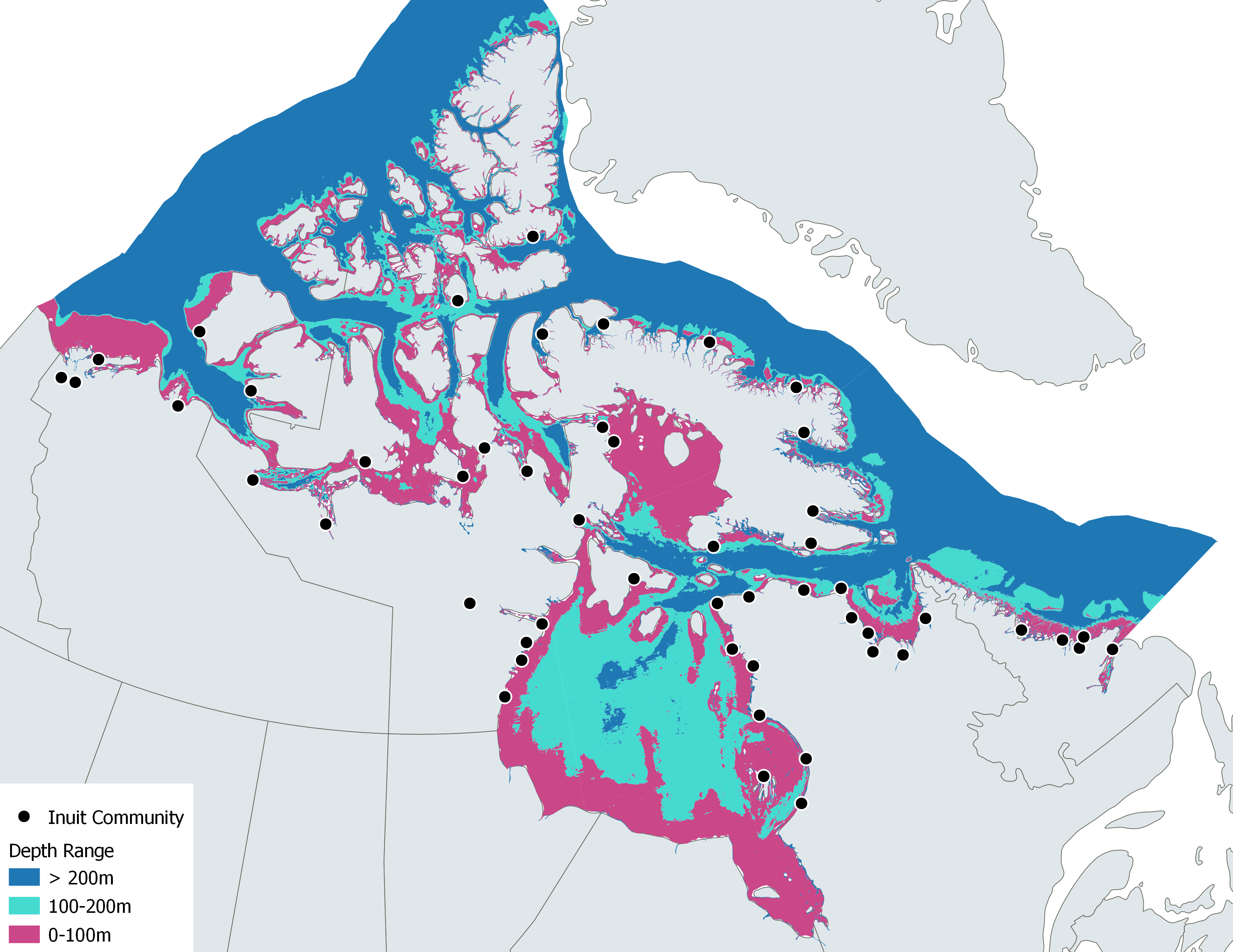
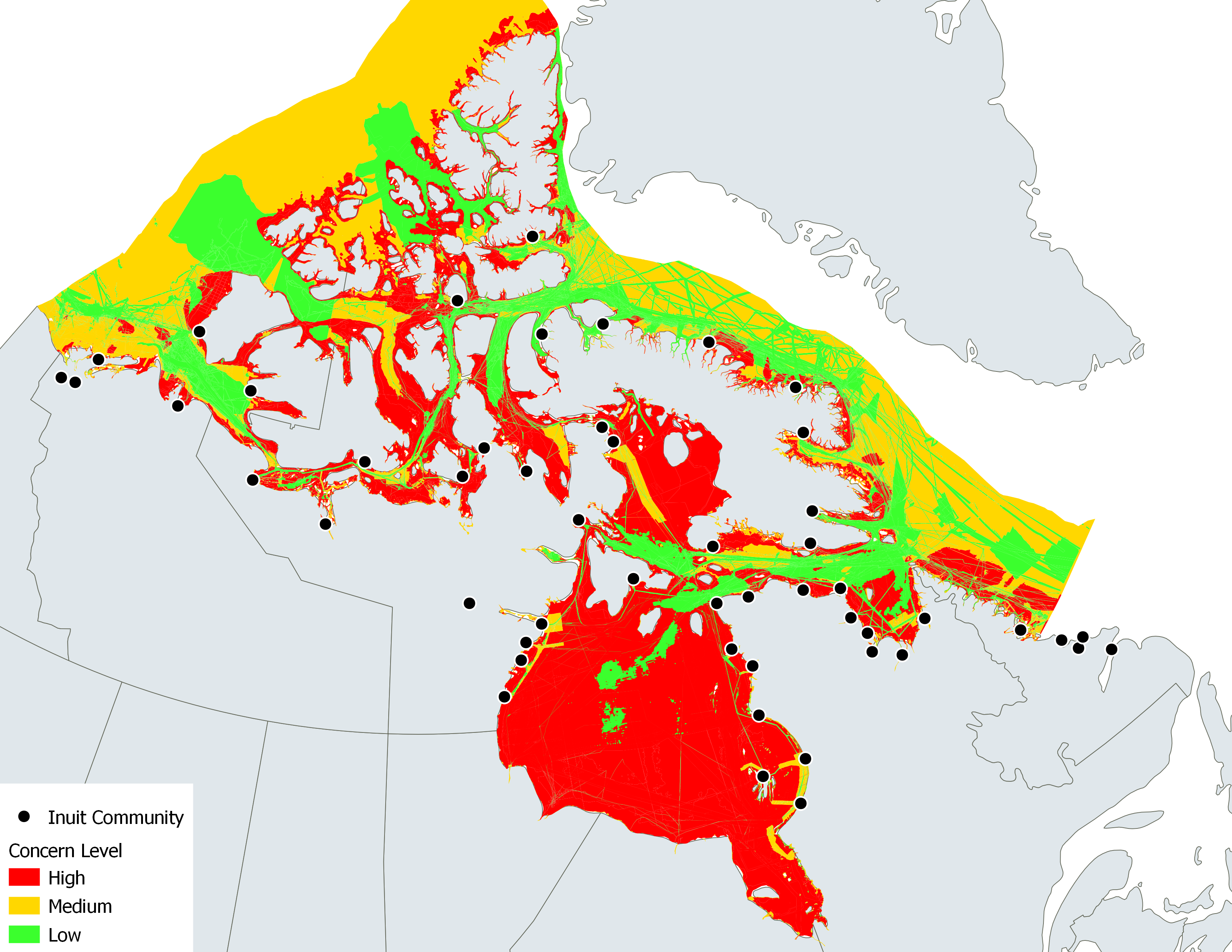
Fig. 1 Canadian Arctic EEZ illustrated according to potential concern for navigation .
2 Method
The Community-Sourced Bathymetry approach stems from work carried out under the CHS Community Hydrography Program (DFO, 2026; Rondeau et al., 2024) which has generated strong interest and engagement within Inuit communities specifically.
This approach shares common ground with crowdsourced bathymetry in that it relies on standard instruments and involves non-experts in hydrography. However, it goes further by emphasizing community engagement and capacity building, and directing deployments toward priority areas that are poorly surveyed or entirely unsurveyed.
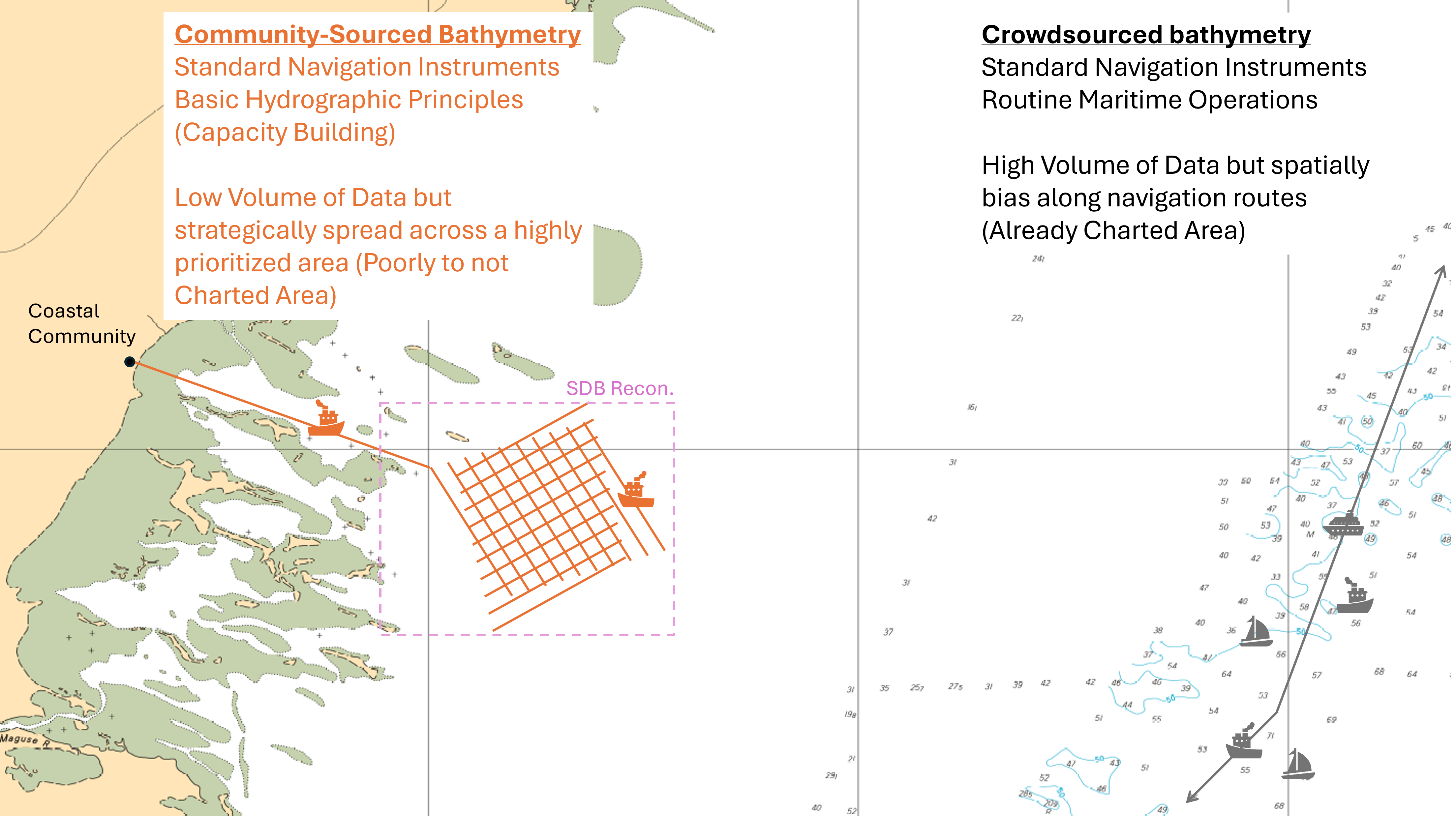
The International Hydrographic Organization defines crowdsourced bathymetry (CSB) in its B-12 publication (IHO, 2022) as the collection and sharing of depth measurements from vessels, using standard navigation instruments, while engaged in routine maritime operations.
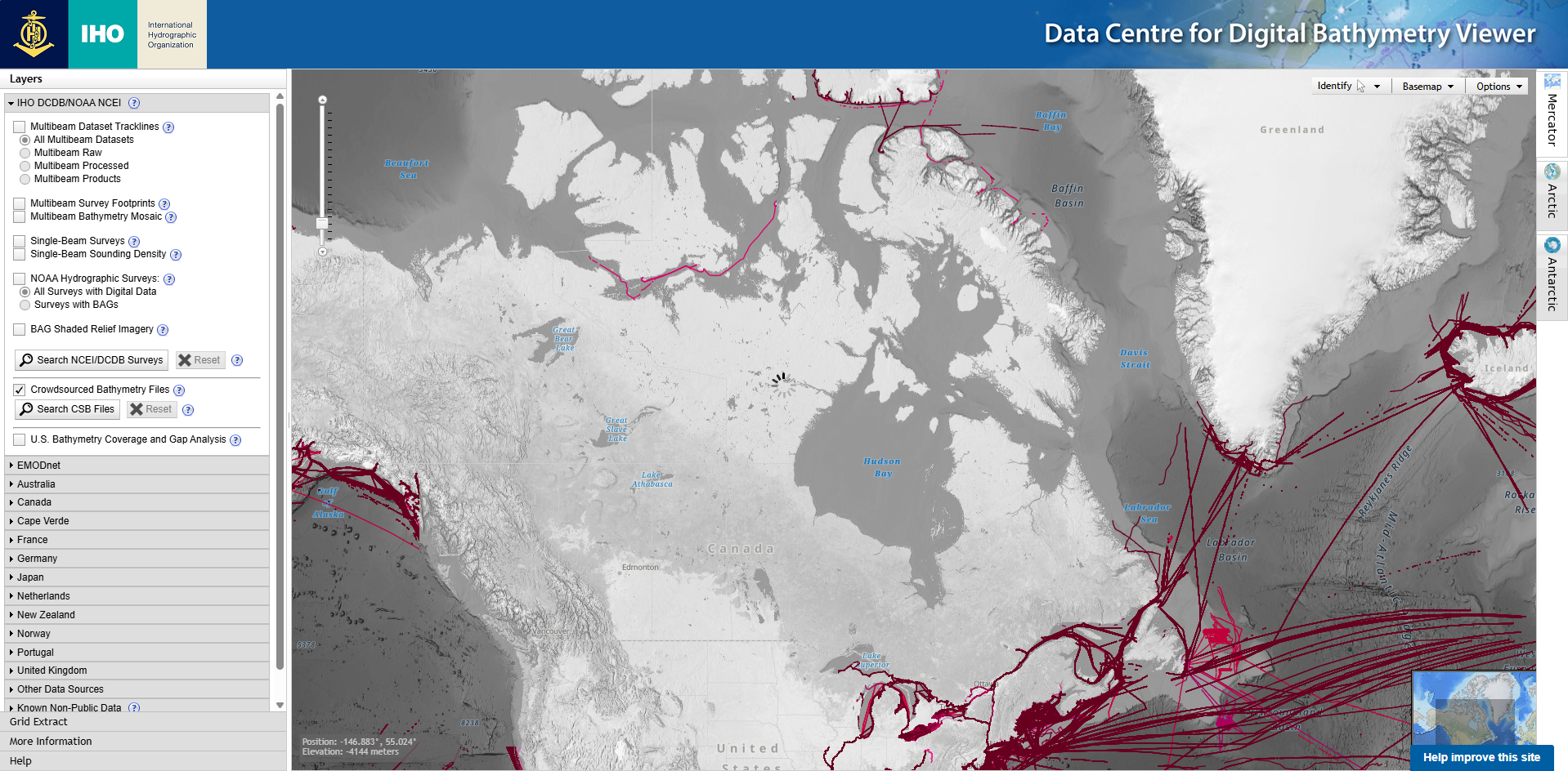
This definition offers certain advantages that are retained in the proposed approach, such as the use of standard navigation instruments and the principle that recognizes and encourages the contribution of bathymetric data from non-institutional sources. However, collecting bathymetric data during routine maritime operations presents clear limitations, as the observed collection patterns are suboptimal from a hydrographic perspective. First, CSB platforms often generate substantial measurements “noise”. Causes can be attributed to: bottom tracking loss due to high speed or sudden depth change, cavitation under transducer, sensor interference or poorly adjusted sonar parameters. Second and more importantly, data collection tends to follow the main navigation routes and concentrate in areas where charting products already exist, leaving critical gaps in unsurveyed regions. In Canada, most of the CSB data available in the IHO Data Centre for Digital Bathymetry (DCDB) are located along the St-Lawrence River, the Great Lakes corridor and the Juan de Fuca Strait, leaving the Arctic largely untouched except for a single contribution in the Northwest Passage – which further illustrates the spatial bias toward major navigation routes mentioned earlier – and a few additional datasets on the northeastern coast of Baffin Island (Fig. 2).
Community-Sourced Bathymetry therefore proposes adapting the IHO definition by shifting from opportunistic data collection to directed data collection (Fig. 3). Community-Sourced Bathymetry can be defined as the collection of depth measurements from community vessels, using calibrated standard navigation instruments and following basic hydrographic principles while engage in dedicated survey operations.
The Community-Sourced Bathymetry approach can be broken down into six main operational tasks:
- Support and capacity building. Assess local capacity and needs, outfit community boats with standard navigation instruments and data loggers, measure lever-arms – with particular attention to the sonar’s draft measurement – and train the local survey crews.
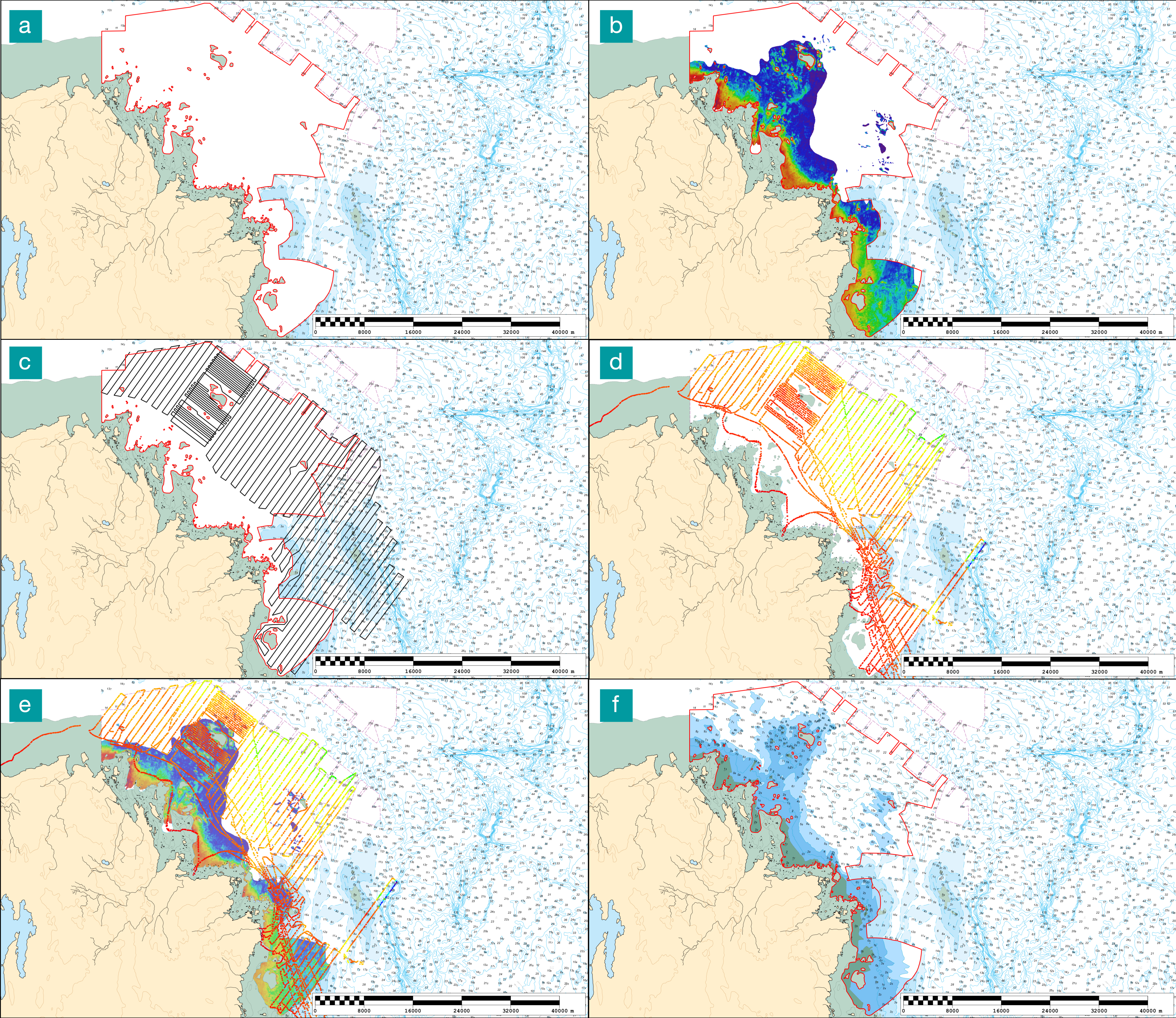
- Survey planning and preparation. Task an SDB 2 reconnaissance survey over the areas of interest, identify shallow hazards (dangers to navigation), and design tailored, risk-assessed (informed by SDB) systematic survey grids adapted to expected depth variability and boats capabilities.
- Community-Sourced Bathymetry data collection. Conduct bathymetric data collection over the areas of interest, following the systematic survey grids at an appropriate survey speed.
- Bathymetric data processing and qualification. Perform tidal/water-level reduction3, filter outliers, assess Total Vertical Uncertainty (TVU) per-sounding4.
- SDB calibration using Community-Sourced Bathymetry (optional). Adjust and refine the initial SDB depth model (from Step 2) using the validated in situ bathymetric data collected by the local survey crews5.
- Quality evaluation and integration. Assess data quality using peer-comparison tools, verify consistency with existing datasets, populate metadata, and integrate validated data into navigational products.
Below is an overview of how the Community-Sourced Bathymetry approach was applied in the Asuqaaq area at the mouth of the Koksoak River by two survey crews from the Inuit community of Kuujjuaq (QC) (Fig. 4).
3 Data
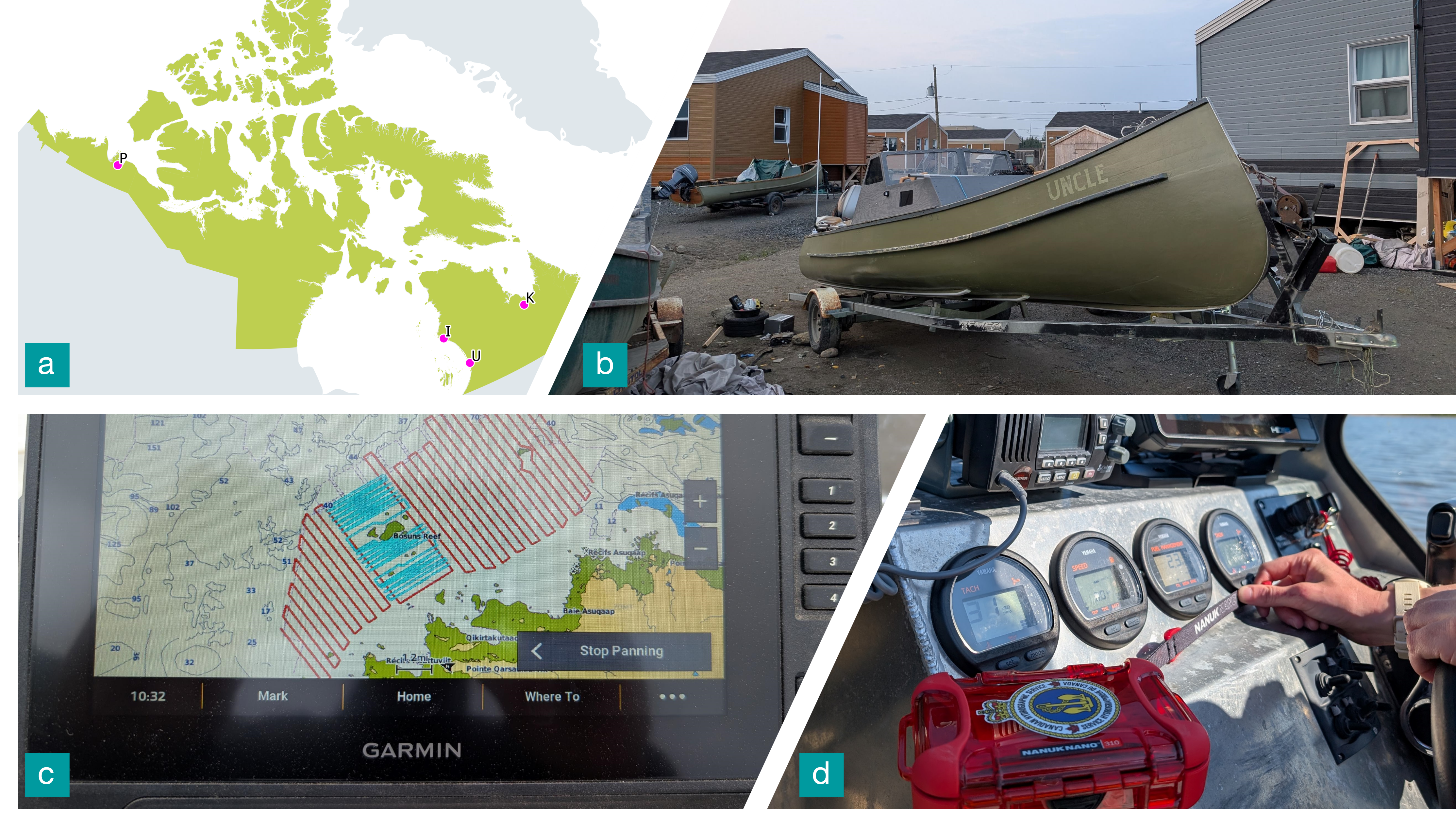
Over the past three years, projects have been initiated by the CHS Community Hydrography Program. Dataloggers have been logging a significant amount of bathymetric data – some collected opportunistically (passage survey as define by the IHO) during transit between communities or while traveling for harvesting, fishing and hunting, and some collected systematically (systematic survey as define by the IHO) in specific areas. All data were processed and transformed into community maps, which were disseminated to the communities through Transport Canada’s Enhanced Maritime Situational Awareness App (TC, 2025a) and the Arctic Eider Society’s SIKU App (Segal et al., 2025). The practicality and accessibility of the approach have resonated within Inuit communities.
Among all the data collected since 2023, four use cases illustrate remarkably well the Community-Sourced Bathymetry approach defined previously: Paulatuk (NT), Inukjuak (QC), Kuujjuaq (QC) and Umiujaq (QC). In these communities, Inuit crews were able to collect data from predefined survey line patterns.
As described in the method, local survey crews used small community boats outfitted with “off-the-shelf” bathymetric equipment (fish finders). Teams were asked to follow predefined line patterns, maintain speed under 10 knots, monitor sonar signal loss and restrain data acquisition in adverse sea conditions (Fig. 5).
Although they are not hydrography experts, the bathymetric data collected by the four Inuit crews, once processed and assessed, compare favorably with single-beam echo sounder data collected by CHS in the 1990s.
4 Results
To demonstrate that data collected in the 2020s by non experts using “off-the-shelf” bathymetric equipment (fish finders) and applying basic hydrographic principles can compare in terms of quality with data collected in the 1990s by CHS, a quantitative study, presented below, was conducted.
The study involves submitting to a peer consistency assessment, (1) the Community-Sourced Bathymetry (CoSB) datasets (n = 19) produced since the launch of the Community Hydrography Program (2023), as well as (2) historical single-beam (SBES) surveys (n = 586) collected in the Canadian Arctic nearshore (0-100m depth range) by CHS since the 1950s.
To this end, a systematic quantitative analysis was carried out based on a peer comparison script. This script evaluates each submitted dataset by comparing it with reference surveys. A reference survey is defined as one that:
- overlaps (even partially) with the dataset being evaluated;overlaps (even partially) with the dataset being evaluated;
- was conducted using a multibeam echosounder (MBES);
- has been assigned a Category of Zone Of Confidence (CATZOC) A1 or A2 as defined in the IHO, S-68 Standards (IHO, 2025); and
- is validated for integration into official charts.
All datasets were reduced to chart datum prior to comparison to ensure vertical consistency. Reference MBES surveys are stored as gridded surfaces, whereas CoSB and SBES datasets consist of point soundings. The comparison is therefore performed by matching each evaluated sounding to the corresponding depth value from the MBES reference grid. Surface differencing was conducted using Teledyne CARIS Base Editor software, with the MBES grid defining the spatial reference framework. Horizontal matching tolerance is thus implicitly controlled by the grid resolution.
For each dataset, depth differences between evaluated soundings and reference surfaces were computed and summarized by key statistics such as the mean of differences, median of differences, and standard deviation of differences. The distribution of residuals provides an empirical estimate of overall consistency.
The characteristics of the datasets that passed the peer comparison step (i.e., those for which at least one reference survey was identified) are presented in Table 1.
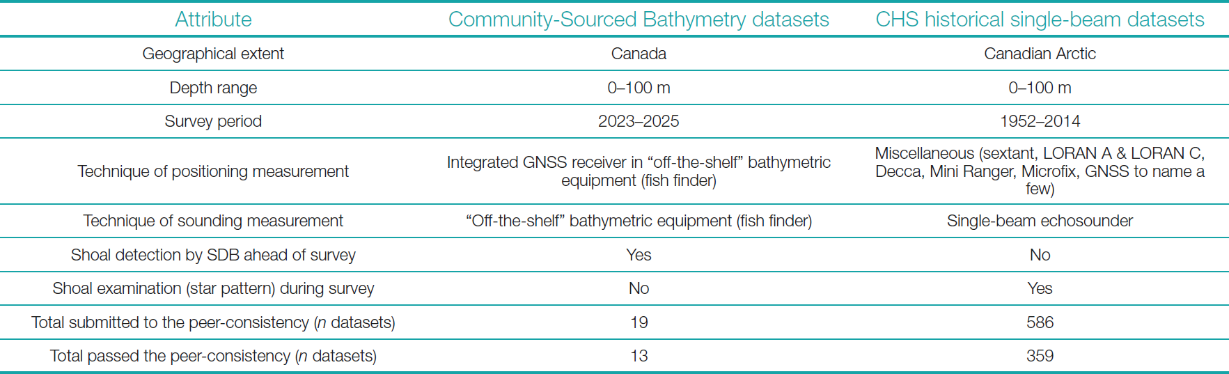
Among the datasets submitted to the peer-consistency assessment, 13 Community-Sourced Bathymetry datasets and 359 CHS historical single-beam datasets show overlap with MBES reference surveys. The quantitative consistency analysis conducted shows that Community-Sourced Bathymetry datasets exhibit a level of agreement with the MBES reference that places them in the 61th percentile of the CHS historical datasets when classified from 1 (very poor fit) to 100 (very good fit) (Fig. 6). On a historical perspective, when CHS single-beam datasets are split by decade (1950s–2010s), the results indicate that Community-Sourced Bathymetry surveys outperform CHS single-beam surveys from the 1950s-80s, match the performance of 1990s CHS single-beam surveys, but underperform compared to CHS single-beam surveys conducted since 2000s (Fig. 7). On a data quality perspective, when CHS single-beam datasets are split by CATZOC (B, C, D), the results indicate that Community-Sourced Bathymetry surveys demonstrate performances consistent with the range of CHS SBES CATZOC B surveys (Figs. 8 and 9). This comparison is based solely on the “Depth accuracy” criterion, from among the broader set of criteria defined in the IHO S-68 Guidelines for CATZOC allocation.
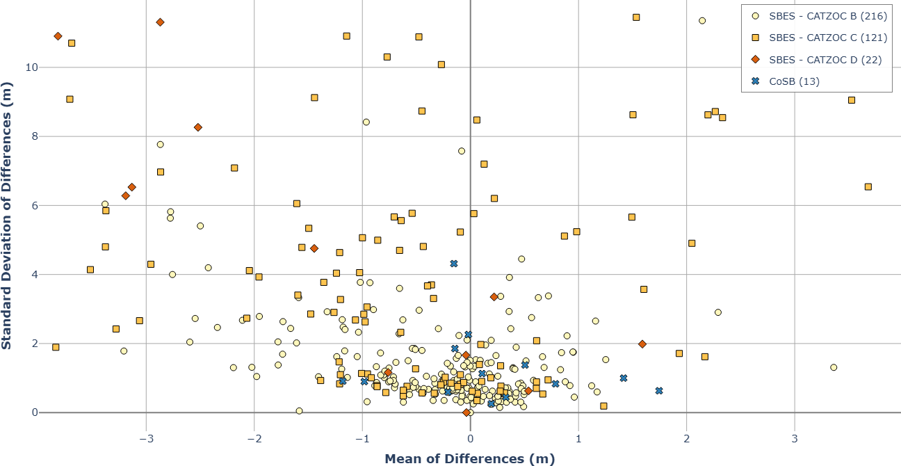
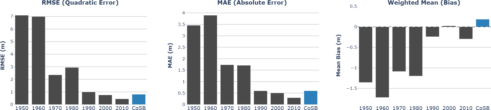
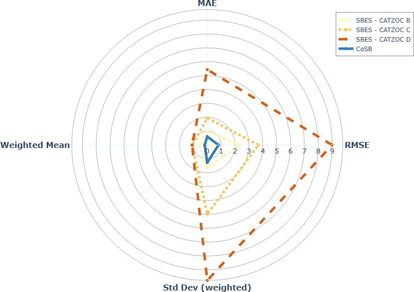
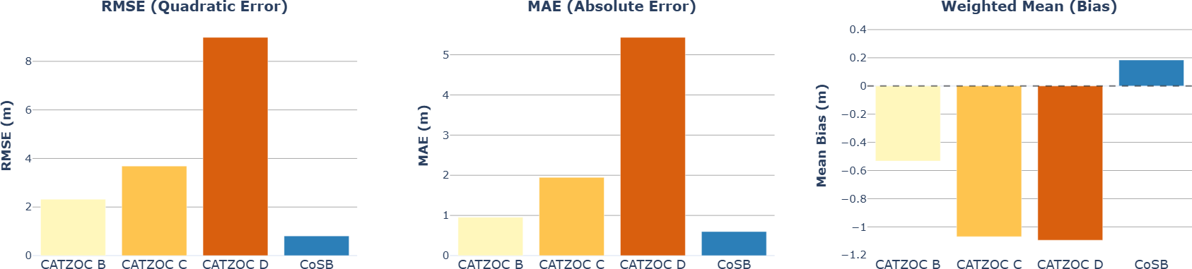
Table 2 summarizes the key statistics to support comparison between Community-Sourced Bathymetry and CHS CATZOC B single-beam datasets. The error statistics show that Community-Sourced Bathymetry agrees more closely with the reference depths than CHS CATZOC B datasets, both in overall accuracy and consistency. Community-Sourced Bathymetry has a lower Root Mean Square Error (RMSE) (0.81) and lower Mean Average Error (MAE) (0.60), indicating smaller typical vertical differences and fewer large mismatches than CHS CATZOC B datasets (RMSE 2.32, MAE 0.95). The fact that CHS CATZOC B’s RMSE is much larger than its MAE suggests the presence of occasional outliers (since RMSE penalizes large deviations more strongly). The weighted mean reflects systematic bias in the signed residuals. Community-Sourced Bathymetry’s +0.18 indicates a slight tendency toward deeper depths than the reference, while CHS CATZOC B’s -0.53 indicates a tendency toward shallower depths. Finally, the standard deviation confirms that Community-Sourced Bathymetry residuals are more tightly clustered (1.27) than CHS CATZOC B datasets (1.66), meaning Community-Sourced Bathymetry is not only more accurate on average, but also more consistent across the area.

The quantitative analysis presented in this study is subject to several limitations that warrant explicit consideration.
First, the evaluation framework assumes that the reference datasets – MBES surveys categorized as CATZOC A1/A2 and qualified as validated – are treated as a high-confidence reference standard. Under this assumption, all discrepancies identified by the peer comparison tool are attributed solely to the dataset under evaluation. This premise is inherently imperfect, particularly in Arctic environments, where temporal advances in positioning systems and sonar technology, refinement of water level separation models, and the presence of dynamically changing seabed conditions introduce uncertainties that limit the absolute reliability of historical MBES data. As such, these reference datasets, while of high quality, cannot be considered fully invariant benchmarks.
Second, the volume of Community-Sourced Bathymetry data available for analysis remains relatively modest (13 datasets). Although the results indicate a positive and encouraging trend in dataset quality, achieving stronger statistical robustness will require an increase in both the number and geographic diversity of community sourced surveys.
Third, the analysis intentionally does not apply weighting based on the number of soundings contributing to each comparison. Accordingly, a dataset evaluated using only two soundings contributes equally to the final synthesis (Figs. 6–8) as a dataset evaluated with 10,000 soundings. This methodological choice was made to avoid introducing subjective weighting biases that would systematically favor more recent surveys – typically characterized by higher sounding density – over older datasets from the 1950s–1960s–1970s. While unweighted aggregation simplifies interpretation and avoids temporal bias, it does reduce sensitivity to dataset specific robustness.
Despite these limitations, the analysis offers a first-order assessment of the data holdings available in remote Canadian Arctic regions. By adopting a conservative but consistent evaluation framework, the comparison offers a sound basis for understanding the relative performance of Community-Sourced Bathymetry and CHS historical surveys.
5 Discussion
Inuit have lived in and occupied Inuit Nunangat since time immemorial. Inuit Tapiriit Kanatami (ITK) has recently articulated the vision of Inuit for involvement in Arctic sovereignty, security, and defence (ITK, 2025). Specifically for the maritime Arctic, Inuit express their desire to play a central role: to be consulted, involved in priority-setting, and have local knowledge recognized and valued. They seek safe access for harvesting, effective monitoring, and robust search and rescue (SAR) capabilities, all of which require improved charting of the nearshore.
In the Canadian Arctic, CHS’s charting approach focuses on navigation corridors to support commercial shipping, such as sea-lift, to resupply northern communities. Within these corridors, charting quality, as defined in the IHO, S-67 Standards (IHO, 2020), is good (CATZOC A1–A2) based on modern multibeam bathymetric data. Outside the corridors, however, charting quality is typically lower (CATZOC C or D), relying on historical bathymetric data collected over many decades using a range of evolving techniques – from sextant and leadline to GNSS and single beam echosounder – but always with a focus on identifying and examining shoals to support navigation safety.
While the proposed Low Impact Shipping Corridors (LISC) co-developed by Transport Canada and CHS with Inuit communities (Dawson et al., 2019; TC, 2025b) represent an important step toward enhancing safety of community resupply (sealift) and commercial shipping, they primarily focus on established maritime transit routes. As a result, several community‑relevant needs remain outside the current scope of the LISC framework, including:
- Search and rescue (SAR) operations in the nearshore
- Safe inter-community marine transit
- Local economic development (e.g. fishing, hunting)
- Establishment and management of marine protected areas
- Environmental response (e.g. oil spill)
The Arctic nearshore – used heavily for fishing, hunting, and inter-community transit – is vital for Inuit coastal communities and other Arctic water users (e.g. Commercial shipping sector, Canadian Coast Guard and Canadian Coast Guard Auxiliary, Department of National Defence, Royal Canadian Navy, Transport Canada, Parks Canada, Scientists, Fisheries industry, Cruise tourism operators, and Recreational boaters). Better knowledge of nearshore seafloor could:
- Enhance Arctic navigation safety
- Increase community resilience (i.e. socially, economically, environmentally)
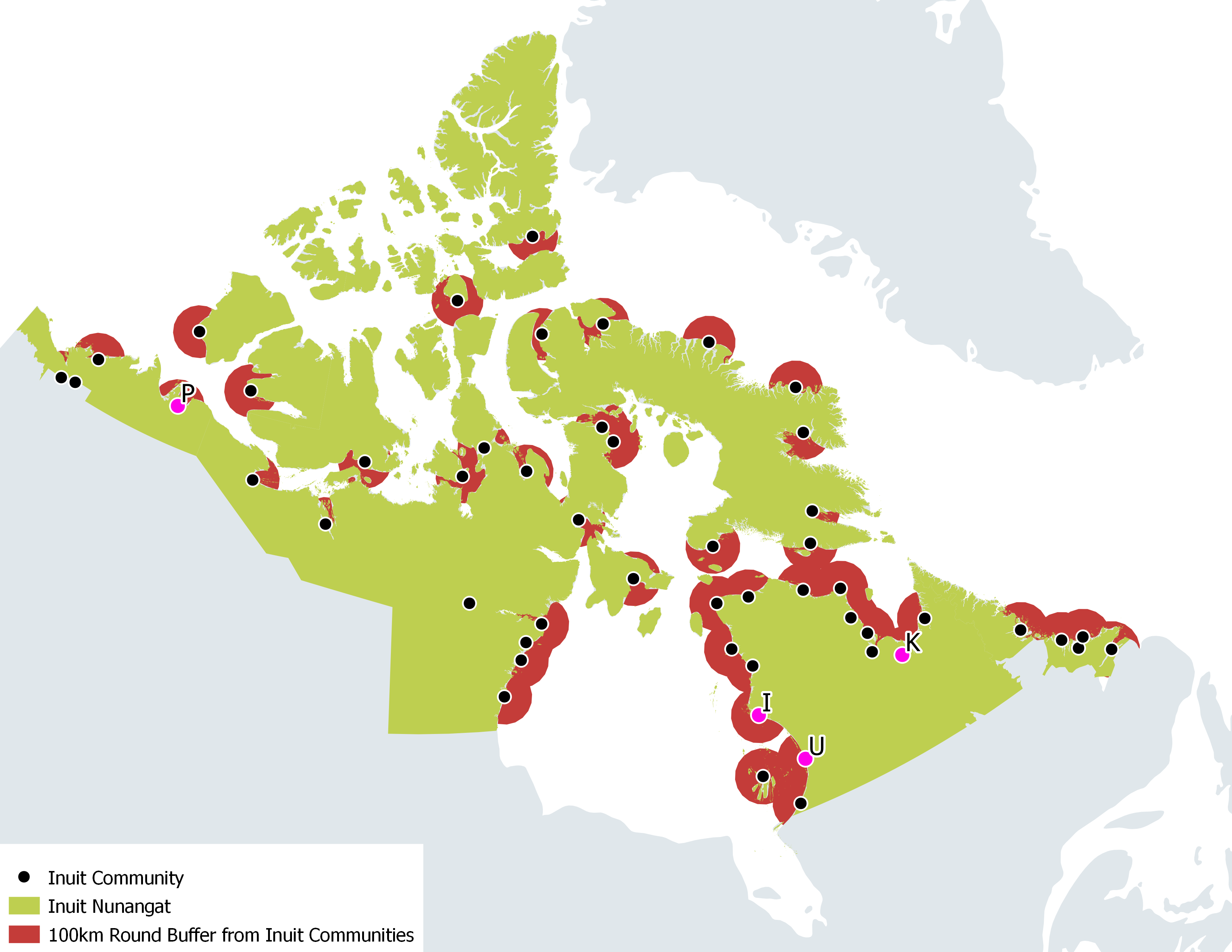
Inuit in Canada have shown strong interest in participating in seafloor mapping initiatives (ITK, 2023). Four of the 51 communities in Inuit Nunangat have already demonstrated their capacity to collect bathymetric data favorably comparable to CHS historical single beam echo sounder datasets acquired in the 1990s, including at distances of up to 100 km from their home communities. If all communities across Inuit Nunangat were to deploy community boats equipped with standard navigation instruments following the Community-Sourced Bathymetry approach described earlier, up to 16 % of Canada’s coastal zone within the 0–200 m depth range could be mapped up to a CATZOC B quality level (Fig. 10). This increased coverage would reduce the potential concern for navigation in these areas from high to medium. It is important to note, however, that achieving this level of coverage in practice would depend on several factors, including logistical feasibility and local capacity to implement and sustain such initiatives across all communities. The figure should therefore be viewed as an aspirational estimate rather than a guaranteed outcome.
The governance model surrounding the involvement of Inuit communities in supporting coastal mapping in the Arctic region has not been examined in this study. The focus here was solely on demonstrating the potential – both in terms of data quality and coverage capability – of the Community-Sourced Bathymetry approach. Questions related to the distribution of roles and responsibilities, funding and capacity building for survey teams, as well as data control and data sharing, will need to be addressed in future work.
6 Conclusion
This study highlights the potential of Inuit communities to contribute meaningfully to Arctic nearshore mapping through the Community-Sourced Bathymetry approach. Using common, commercially available navigation instruments and applying basic hydrographic principles – i.e., measuring sensor offsets (with particular attention to sonar draft), following systematic survey grids, operating at appropriate survey speeds (<10 kt), and applying tidal or water‑level reductions – Inuit survey crews produced bathymetric data comparable to CHS historical single-beam surveys (1990s) still used in many Arctic charting products.
This demonstrates that locally operated vessels, when supported with training, planning tools, and appropriate quality control procedures, can play a role in addressing long standing charting gaps. Beyond the technical results, the approach strengthens local capacity, supports Inuit priorities for safety, sovereignty, and environmental stewardship, and fosters deeper collaboration between CHS and northern communities.
While expanding the number and geographic distribution of surveys would be essential to reinforce statistical robustness, the early results are promising. Community-Sourced Bathymetry offers a scalable, cost effective, and community driven model that can enhance Arctic hydrography and increase the resilience and safety of those who rely on these waters.
Acknowledgments
The CHS Community Hydrography Program is a five-year initiative (2022–2027) funded under the Government of Canada’s Oceans Protection Plan (OPP2). Since its inception, strong working relationships have been developed and maintained with many individuals from communities, governments, universities, the private sector, and NGOs. We are extending our sincere thanks to all of them, with special recognition to Angus Green and the Paulatuk Hunters and Trappers Committee team; Johnny Kasudluak and the Northern Village of Inukjuak team; Jeffrey Gordon, George Kauki and the Kuujjuaq LNUK team; Bobby Tooktoo and the Parc national Tursujuq team, who were instrumental in advancing the success of the Community-Sourced Bathymetry approach in their respective communities.
References
Bazowsky, D., Mallace, D., Day, M. and MacKenzie, R. (2021). Autonomous Survey in Northern Environments. The International Hydrographic Review, 25. https://ihr.iho.int/articles/autonomous-survey-in-northern-environments (last accessed 23 April 2026).
Bilodeau, Y. (2025). CHS-CSB-Processing: Tools for processing crowdsourced bathymetry (CSB) data for the Canadian Hydrographic Service. https://doi.org/10.5281/zenodo.17534827
Chénier, R., Abado, L. and Jirovec, A. (2022). CHS priority planning tool – A GIS to prioritize data gaps. The International Hydrographic Review, 28, 238–242. https://doi.org/10.58440/ihr-28-n13
Cooper, B. (2021). Effectively Mapping and Charting of Remote Locations with Satellites, Lasers and Acoustics. The International Hydrographic Review, 26. https://ihr.iho.int/articles/effectively-mapping-and-charting-of-remote-locations-with-satellites-lasers-and-acoustics/ (last accessed 23 April 2026).
Dawson, J., Carter, N., Van Luijk, N., Parker, C., Weber, M., Cook, A., Grey, K. and Provencher, J. (2019). Infusing Inuit and local knowledge into the Low Impact Shipping Corridors: An adaptation to increased shipping activity and climate change in Arctic Canada. Environmental Science & Policy, 105, 19–36. https://doi.org/10.1016/j.envsci.2019.11.013
de Andrade, E. M., Sales, J. S. and Fernandes, A. C. (2025). Operative Unmanned Surface Vessels (USVs): A Review of Market-Ready Solutions. Automation, 6(2), 17. https://doi.org/10.3390/automation6020017
Devereaux, D., Murphy, J. and Buesseler, B. (2025). Arctic Hydrographic Risk Assessment 2025 Update. 15th Conference of the Arctic Regional Hydrographic Commission (ARHC), Anchorage & Nome, Alaska, USA, 8–10 September 2025.
Dolou, H., Laporte, J., Avis, J. and Arino, O. (2020). Thirty years of satellite derived bathymetry – The charting tool that hydrographers can no longer ignore. The International Hydrographic Review, 24, 129–154. https://ihr.iho.int/articles/thirty-years-of-satellite-derived-bathymetry-the-charting-tool-that-hydrographers-can-no-longer-ignore/ (last accessed 23 April 2026).
DFO (2025). About the Canadian Hydrographic Service. Department of Fisheries and Oceans Canada (DFO), Government of Canada, Canada. https://www.charts.gc.ca/help-aide/about-apropos/index-eng.html#legal (last accessed 23 April 2026).
DFO (2026). Community hydrography. Department of Fisheries and Oceans Canada (DFO), Government of Canada, Canada. https://www.dfo-mpo.gc.ca/science/hydrography-hydrographie/opp-ppo/index-eng.html (last accessed 7 January 2026).
Goodrich, K. (2025). Beyond either/or: integrating hydrographic technologies for a data-driven future. Hydro International. https://www.hydro-international.com/content/article/beyond-either-or-integrating-hydrographic-technologies-for-a-data-driven-future (last accessed 1 October 2025).
Hains, D., Keating, S. G., Rathnayake, C., Obura, V., Sharma, S. and Hall, S. (2024). Citizen hydrospatial sciences – To csB or not to csB, that is the question! The International Hydrographic Review, 30(1), 162–170. https://doi.org/10.58440/ihr-30-1-n02
HDACoE (2025). CHS Bathymetric Gap Analysis 2025. Hydrographic Data Access Centre of Expertise, Canadian Hydrographic Service, Canada.
IHO (2020). Mariners’ Guide to Accuracy of Depth Information in Electronic Navigational Charts (ENC) (1st ed.). IHO Special Publication S-67, International Hydrographic Organization, Monaco. https://iho.int/uploads/user/pubs/standards/S-67/S-67%20Ed%201.0.0%20Mariners%20Guide%20to%20Accuracy%20of%20Depth%20Information%20in%20an%20ENC_EN.pdf (last accessed 23 April 2026).
IHO (2022). Guidance to crowdsourced bathymetry (3rd ed.). IHO Publication B-12, International Hydrographic Organization, Monaco. https://iho.int/uploads/user/pubs/bathy/B_12_CSB-Guidance_Document-Edition_3.0.0_Final.pdf (last accessed 23 April 2026).
IHO (2024a). Guidance to Satellite-derived Bathymetry (1st ed.). IHO Publication B-13, International Hydrographic Organization, Monaco. https://iho.int/uploads/user/pubs/bathy/B_13_Ed100_032024.pdf (last accessed 23 April 2026).
IHO (2024b). Standards for Hydrographic Surveys (ed. 6.2.0). IHO Special Publication S-44, International Hydrographic Organization, Monaco. https://iho.int/uploads/user/pubs/standards/s-44/S-44_Edition_6.2.0_adopted.pdf (last accessed 23 April 2026).
IHO (2025). Guidelines and Recommendations for Hydrographic Offices for the Allocation of CATZOC/QOBD Values from Survey Data. IHO Special Publication S-68, International Hydrographic Organization, Monaco. https://iho.int/uploads/user/pubs/standards/S-68/S-68_Guidelines_Allocation_of_CATZOC_Ed_1.0.0.pdf (last accessed 23 April 2026).
IHO (2026). Status of Hydrographic Surveying and Charting Worldwide. IHO Capacity Building Publication C-55, International Hydrographic Organization, Monaco. https://iho.int/en/iho-c-55 (last accessed 23 April 2026).
ITK (2023). The oceans that we share: Inuit Nunangat Marine Policy Priorities and Recommendations. Inuit Tapiriit Kanatami, Ottawa, Canada. https://itk.ca/wp-content/uploads/2023/03/20230322-Marine-Policy-Paper-FINAL-SIGNED.pdf (last accessed 23 April 2026).
ITK (2025). An inuit vision for Arctic sovereignty, security and defence. Inuit Tapiriit Kanatami, Ottawa, Canada. https://www.itk.ca/wp-content/uploads/2025/06/An-Inuit-Vision-for-Arctic-Sovereignty-Security-Defence.pdf (last accessed 23 April 2026).
Jencks, J. and Baron, B. J. (2024). CSB as part of the modern hydrographic toolbox. The International Hydrographic Review, 30(1), 150–160. https://doi.org/10.58440/ihr-30-1-n03
Knudby, A. (2025). Satellite imagery for hazard detection: Better use of satellite imagery could help prevent groundings in the Canadian Arctic. The International Hydrographic Review, 31(2), 30–43. https://doi.org/10.58440/ihr-31-2-a13
Muthusamy, P., Church, I., Rondeau, M., Bilodeau, Y. and Breton, M. (2025). Crowd-Sourced Bathymetry vertical uncertainty calculation per sounding. Abstracts of the ICA, 10, 1–2. https://doi.org/10.5194/ica-abs-10-209-2025
NOAA (2016). Arctic charting: Mapping a new frontier. National Oceanic and Atmospheric Administration, U.S. Department of Commerce, USA. https://www.noaa.gov/explainers/arctic-charting-mapping-new-frontier (last accessed 23 April 2026).
Rondeau, M., Breton, M., Montpetit-Allard, G., Leger, M., Bilodeau, Y. and Kasudluak, J. (2024). From volunteer ping to community map – The CHS’ Community Hydrography Program. The International Hydrographic Review, 30(1), 64–77. https://doi.org/10.58440/ihr-30-1-a07
Segal, R., Sudlovenick, C., Heath, J., Warner, E., Beale, S. and Chapman, M. (2025). Mapping with SIKU – The Indigenous Knowledge App for environmental data access, land safety, and knowledge sharing across the North. Abstracts of the ICA, 10, 1–2. https://doi.org/10.5194/ica-abs-10-255-2025
TC (2025a). Expanding the Enhanced Maritime Situational Awareness program. Transport Canada, Government of Canada, Canda. https://tc.canada.ca/en/campaigns/protecting-our-coasts-oceans-protection-plan/stronger-partnerships-indigenous-coastal-communities/expanding-enhanced-maritime-situational-awareness-program#about-enhanced (last accessed 23 April 2026).
TC (2025b). Northern Low-Impact Shipping Corridors Initiative. Transport Canada, Government of Canada, Canda. https://tc.canada.ca/en/campaigns/protecting-our-coasts-oceans-protection-plan/stronger-partnerships-indigenous-coastal-communities/northern-low-impact-shipping-corridors-initiative (last accessed 23 April 2026).
Authors’ biographies

Mathieu Rondeau holds a bachelor’s degree in surveying engineering from l’École Supérieure des Géomètres et Topographes (Le Mans, France) and a master’s degree in geomatics sciences from Laval University (Quebec, Canada). From 2009 to 2018, he worked for the Interdisciplinary Centre for the Development of Ocean Mapping (Canada), where he gained most of his expertise in hydrographic surveying. Since 2018, he has been employed by the Canadian Hydrographic Service. For the past four years, he has been an integral member of the Community Hydrography Program team, supporting coastal communities in the collection and use of bathymetric data.
Gabriel Montpetit-Allard began his career as environment and wildlife technician in the private sector. He later obtained a bachelor’s degree in physical geography from the Université du Québec à Rimouski. From 2006 to 2018, he gained professional experience in operational sciences in the private and academic sectors. He then joined the Canadian Hydrographic Service team in 2019. Since 2023, he supervises the bathymetric data acquisition and community outreach unit of the Community Hydrography Program. Through this program, the Community Hydrography team seeks to support coastal communities in their goals to collect, process and use bathymetric data.

Yan Bilodeau, holding a Bachelor’s degree in Geography from the Université du Québec à Montréal, joined the Canadian Hydrographic Service in 2017 as a multidisciplinary hydrographer. In 2019, he transitioned into the role of a geomatics specialist within the Geomatics and Technical Support team, focusing on automation projects and contributing to the development of bathymetric data processing and integration pipelines. Since 2023, Yan has been an integral member of the Community Hydrography Program team, dedicated to assisting coastal communities across Canada in collecting and utilizing bathymetric data.
Jérémie Lemarchand holds a PhD in Earth Sciences and a DESS in Geomatics from the Université du Québec à Montréal. He began his career in hydrography and marine geomatics in 2018, working in the LDGIZC coastal geomorphology laboratory at the Université du Québec à Rimouski. In 2023, he joined the Canadian Hydrographic Service as a member of the Community Hydrography Program team. His work focuses on data processing and support for data acquisition, with an emphasis on meeting community objectives.

Michel Breton has 15 years of experience with the Canadian Hydrographic Service (CHS). Michel initially worked as multidisciplinary hydrographer surveying and charting the west coast of Canada. Over time, a knack for innovation and data management led him onto projects meant at improving data integration in the organization. Since 2019, Michel has been involved in the digital transformation initiative at the CHS, with S-100 implementation, and more recently with crowdsourced bathymetry data. Michel is currently managing the Community Hydrography Program, a program designed to enable coastal communities in Canada to collect and utilize bathymetric data. Michel is representative for Canada on the International Hydrographic Organization (IHO) Crowdsourced Bathymetry working Group (CSBWG).
- https://www.ncei.noaa.gov/maps/iho_dcdb/ (last accessed 15 January 2026).
- https://www.ncei.noaa.gov/maps/iho_dcdb/ (last accessed 15 January 2026).
- Processing is performed using a dedicated tool developed at CHS (Bilodeau, 2025), which is made available as open-source.
- TVU assessment is performed using a dedicated calculation developed in collaboration with University of New-Brunswick (Muthusamy et al., 2025).
- Community-Sourced Bathymetry and SDB are complementary. Community-Sourced Bathymetry provides the ground-truth measurements needed to validate and calibrate SDB in areas where uncertainty is otherwise difficult to assess, while SDB complements Community-Sourced Bathymetry by extending spatial coverage between survey lines in shallow waters (up to ~15 m).
- The Wireless Inexpensive Bathymetry Logger (WIBL) project was initially developed at The Center for Coastal and Ocean Mapping/NOAA-UNH Joint Hydrographic Center at the University of New Hampshire, with grant support from NOAA. See project web page https://wibl.ccom.unh.edu/index.html (last accessed 23 April 2026).