
Abstract
Preamble
Merte P. J. Peeters from MLA College (Plymouth, United Kingdom) has been awarded second prize in the IFHS Student Award 2025 for his Master’s thesis titled “Establishing an Accurate Mean Sea Level Model in the Dutch Caribbean Using Vessel-Based PPP-GNSS Measurements”. The following article presents a concise overview of his award‑winning research.
1 Introduction
Accurate vertical reference systems are fundamental to hydrographic surveying, nautical charting, coastal engineering, and long-term sea-level monitoring. Mean Sea Level (MSL) serves as a key vertical datum for reducing hydrographic measurements and linking marine observations to terrestrial reference frames. In many coastal regions, however, reliable local MSL-ellipsoidal separation models are lacking, forcing hydrographic operations to rely on global geoid or Mean Sea Surface (MSS) models. While these global models perform well offshore, their accuracy often degrades in nearshore and island environments with complex coastlines and steep bathymetry.
In the Dutch Caribbean, the absence of a regionally validated MSL-ellipsoidal separation model has been shown to negatively affect vertical referencing. Hydrographic surveys conducted by the Royal Netherlands Navy Hydrographic Service revealed vertical discrepancies of up to 0.7 metres when using the EGM08 geoid as an ad-hoc alternative for MSL, particularly in coastal zones near Saint Martin and during harbour development works on Sint Eustatius in 2019. Similar inconsistencies were later observed in airborne LiDAR surveys and coastal infrastructure projects, highlighting the limitations of global reference models in this region.
These challenges are exacerbated by the Dutch Caribbean’s geographical and environmental characteristics. The islands are characterised by irregular coastlines, narrow continental shelves, and steep seabed gradients, which complicate the installation and maintenance of conventional tide gauge networks. At the same time, the region is highly vulnerable to the impacts of climate change (Maitland et al., 2023). Small Island Developing States (SIDS) in the Caribbean are particularly exposed to Sea Level Rise (SLR) and increased coastal flooding (Intergovernmental Panel on Climate Change, 2022), making reliable vertical control increasingly critical for safe navigation, coastal development, and environmental management.
Recent advances in Global Navigation Satellite System (GNSS) positioning now enable operational alternatives to conventional tide gauges in the form of Ellipsoidally Referenced Surveying (ERS) (Ligteringen et al., 2014). By combining Precise Point Positioning (PPP-GNSS) with vessel motion sensors and tidal information, it is possible to calculate sea surface heights directly from survey vessels. This method offers greater spatial coverage than shore-based tide gauges and allows the use of legacy survey data collected during routine hydrographic operations. However, vessel-based measurements are affected by environmental and vessel-specific factors, such as tides, draught, squat, vessel motion, and atmospheric pressure, which must be carefully modelled to ensure reliable results.
This study explores the use of vessel-based PPP-GNSS data to develop a regional MSL-ellipsoidal separation model for the Dutch Caribbean. Focusing on the Leeward Islands (Aruba and Curaçao) and the Windward Islands (Saba and Saba Bank), the research combines existing data from a previous survey campaign with tide gauge observations, predicted tides, and satellite altimetry. The aims are to assess the accuracy and uncertainty of vessel-derived separation values, verify their consistency with shore-based benchmarks and global MSS models, and evaluate their suitability for hydrographic and coastal applications in these data-sparse island regions. This work seeks to improve vertical referencing in the Dutch Caribbean and to support the development of a more robust regional geodetic and tidal infrastructure.
2 Research objectives
The objectives of this study are to evaluate the potential of vessel based GNSS measurements for establishing a reliable Mean Sea Level (MSL)-ellipsoidal separation model in the Dutch Caribbean and to assess its suitability for operational hydrographic surveying. Specifically, the study aims to:
- Assess the applicability of existing data from previous survey campaigns for deriving MSL separation values;
- Assess current vertical reference levels and tidal infrastructure in the region, including their limitations. in complex island environments;
- Develop a statistical model that links vessel-based sea-surface height measurements to environmental and vessel-specific parameters such as tides, motion, squat, draught, and atmospheric pressure.
- Validate vessel-derived separation values against independent observations, including shore-based tide gauges and satellite altimetry, and quantify associated uncertainties
Examine the implications of the results for vertical control in data-sparse coastal regions and develop recommendations for future geodetic and tidal infrastructure in the Dutch Caribbean.
3 Materials and methods
3.1 Study sites
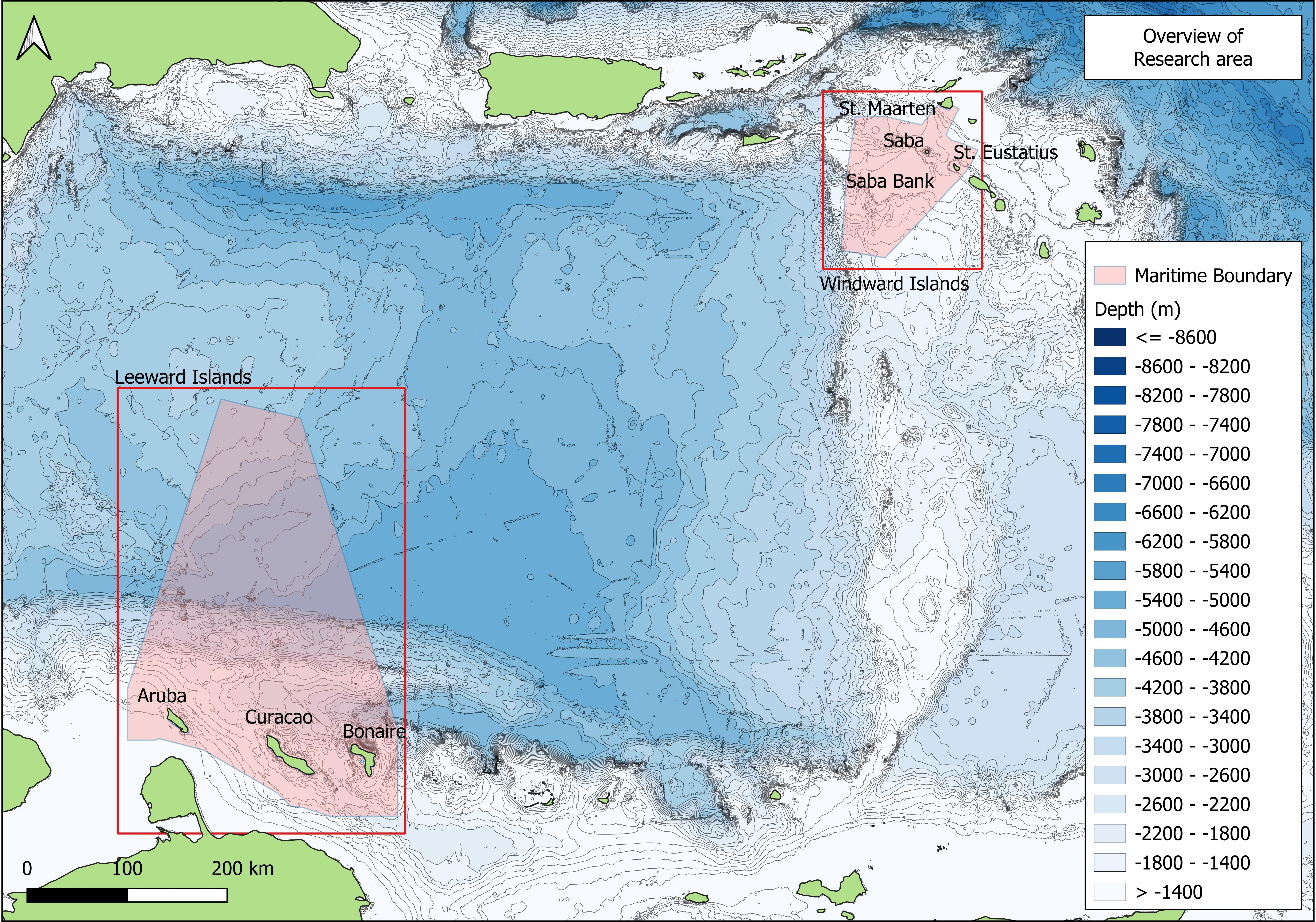
The study was conducted in two distinct regions of the Dutch Caribbean, deliberately selected to represent contrasting coastal, geodetic, and operational conditions. Together, these sites allow evaluation of the vessel-based Mean Sea Level (MSL)-ellipsoidal separation in both well-instrumented coastal settings and data-sparse offshore environments.
3.1.1 Site 1: Leeward Islands (Aruba and Curaçao)
The Leeward Islands (Site 1) comprise the coastal waters surrounding Aruba and Curaçao. This area is characterised by accessible shorelines, developed coastal infrastructure, and the availability of shore based tide gauge (TG) installations, making it suitable for direct validation of vessel derived MSL-ellipsoidal separation values. Both islands exhibit steep nearshore bathymetry, with the continental shelf narrowing rapidly away from the coastline.
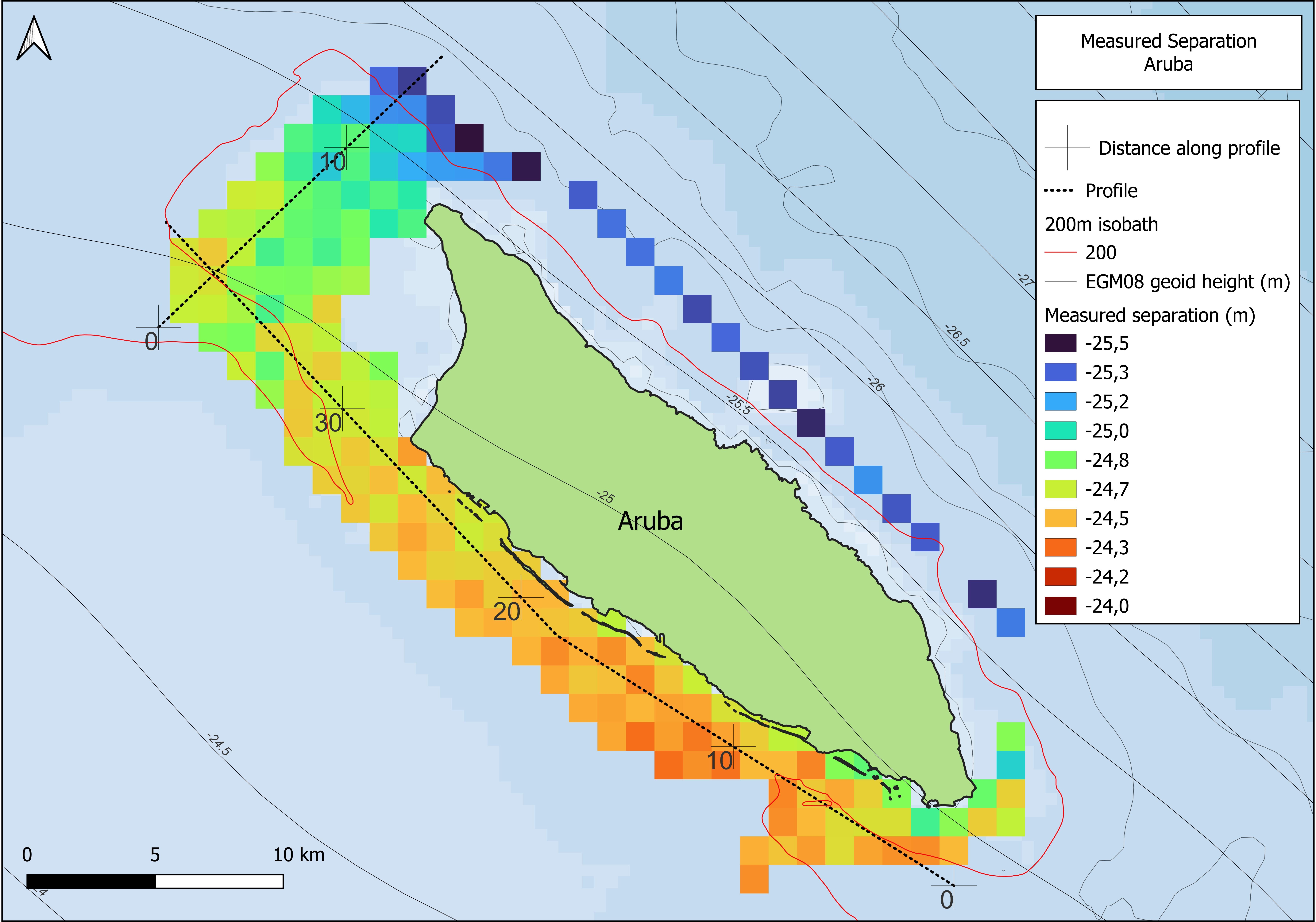
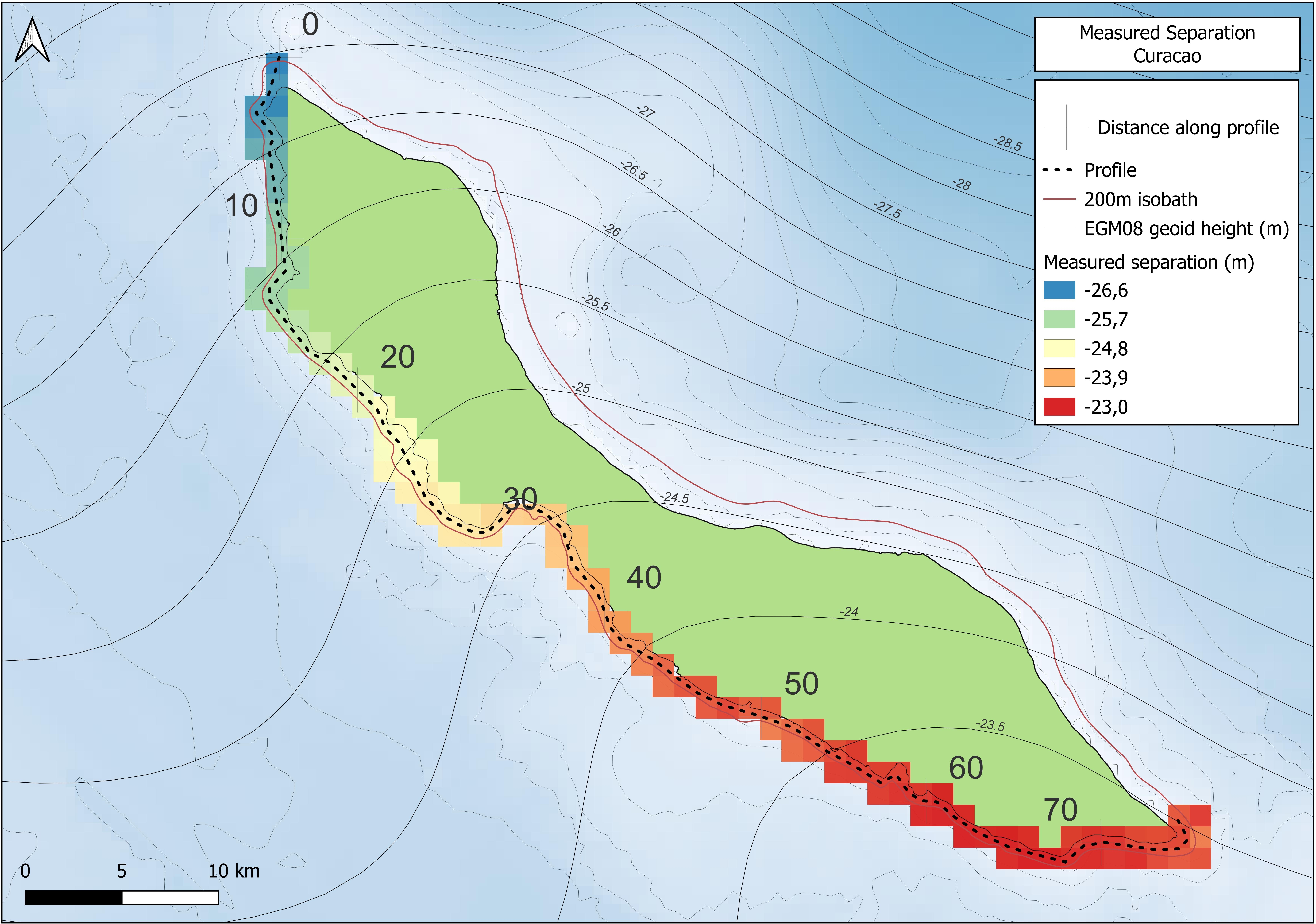
The EGM08 geoidal height varies substantially across Site 1, reflecting complex regional gravity field behaviour. Along the Curaçao coastline, geoidal heights show a pronounced east-west gradient of approximately -23.3 m to -26.7 m, while Aruba exhibits a smaller but still notable north-south variation ranging from approximately -24.7 m to -25.5 m. These spatial gradients make the region particularly sensitive to vertical referencing errors when global geoid or MSS models are used without local validation.
The presence of permanent and temporary tide gauges at multiple locations around Aruba and Curaçao enables the derivation of coastal MSL-ellipsoidal separation values based on static GNSS observations combined with long term tidal records. As such, Site 1 provides a benchmark environment in which vessel based GNSS results can be directly compared with shore based references.
3.1.2 Site 2: Windward Islands (Saba and Saba Bank)
In contrast, the Windward Islands (Site 2) cover the coastal and offshore waters around Saba and the Saba Bank. This area presents a significantly different operational environment, marked by limited coastal access, rugged island terrain, and a lack of extensive shore-based tidal infrastructure. Water depths in the survey zone generally range from 20 m to 40 m, gradually increasing over the Saba Bank.
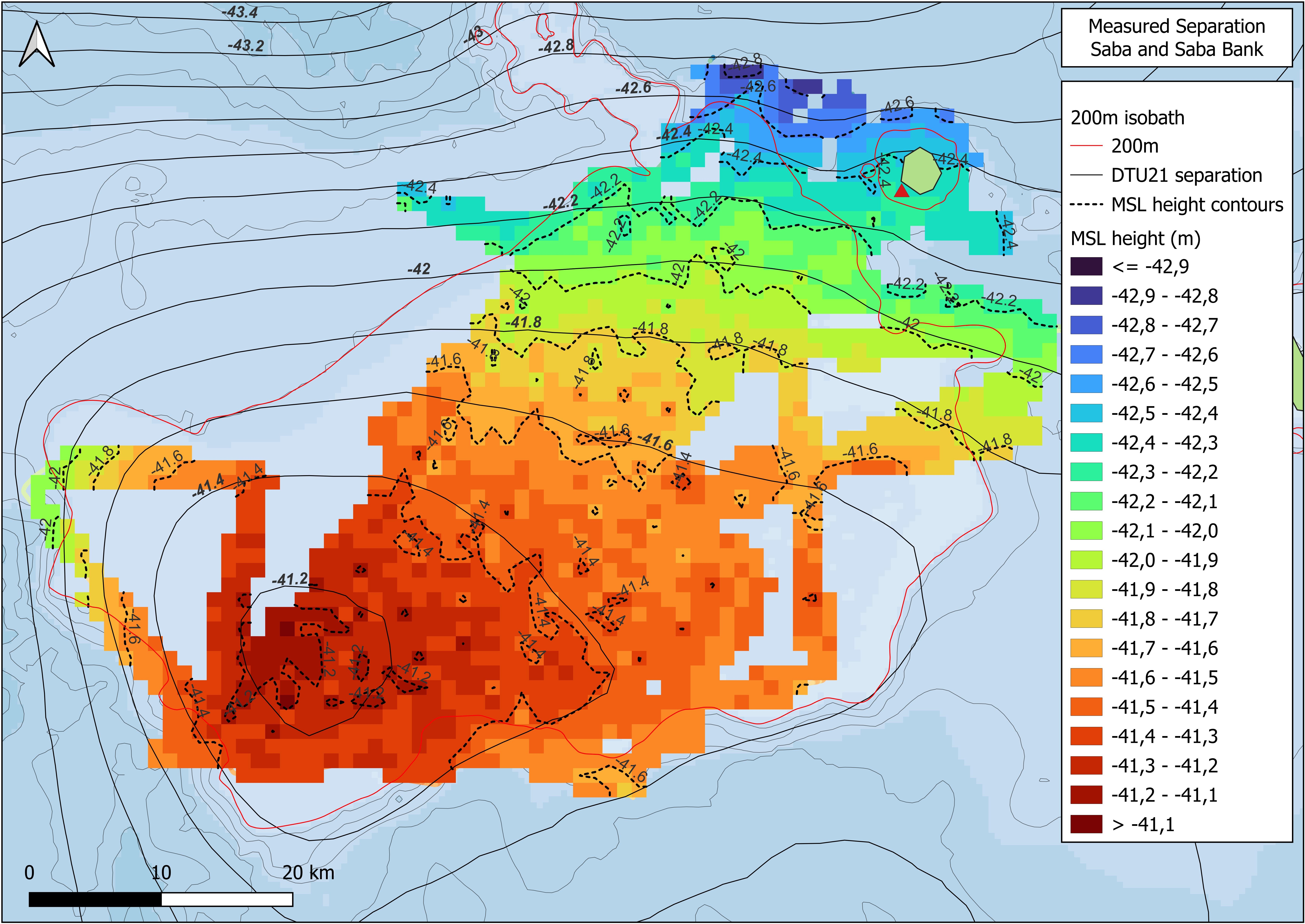
The geoidal height across Site 2 exhibits a relatively smooth but distinct gradient, ranging from approximately -41.6 m to -43.5 m. Unlike Site 1, the lack of accessible coastline and permanent tide gauges necessitated the use of predicted tidal levels derived from harmonic constituents. Consequently, Site 2 serves as a test case for assessing the performance of vessel based separation measurements in areas where conventional tide gauge based vertical control is not feasible.
Together, the two sites provide complementary test environments. Site 1 represents a coastal setting where vessel based separation measurements can be rigorously validated against shore derived MSL references, while Site 2 represents a data sparse offshore environment that relies heavily on predicted tides and vessel based observations. This contrast allows assessment of how environmental conditions, geoidal variability, and data availability influence the accuracy and reliability of vessel derived MSL-ellipsoidal separation.
For both sites, the research area extends from the coastline to the 200 m isobath, aligning with the maximum depth range for tidal reduction as defined by IHO S44 Order 1/2 survey requirements (IHO, 2020). This depth range reflects typical hydrographic survey operations in the Dutch Caribbean and ensures that the derived separation values are applicable for practical charting and coastal purposes.
Fig. 1 provides an overview of the spatial extent of both study sites and highlights the contrasting coastal accessibility, bathymetric gradients, and geographical distribution that underpin the comparative
3.2 Vessel setup
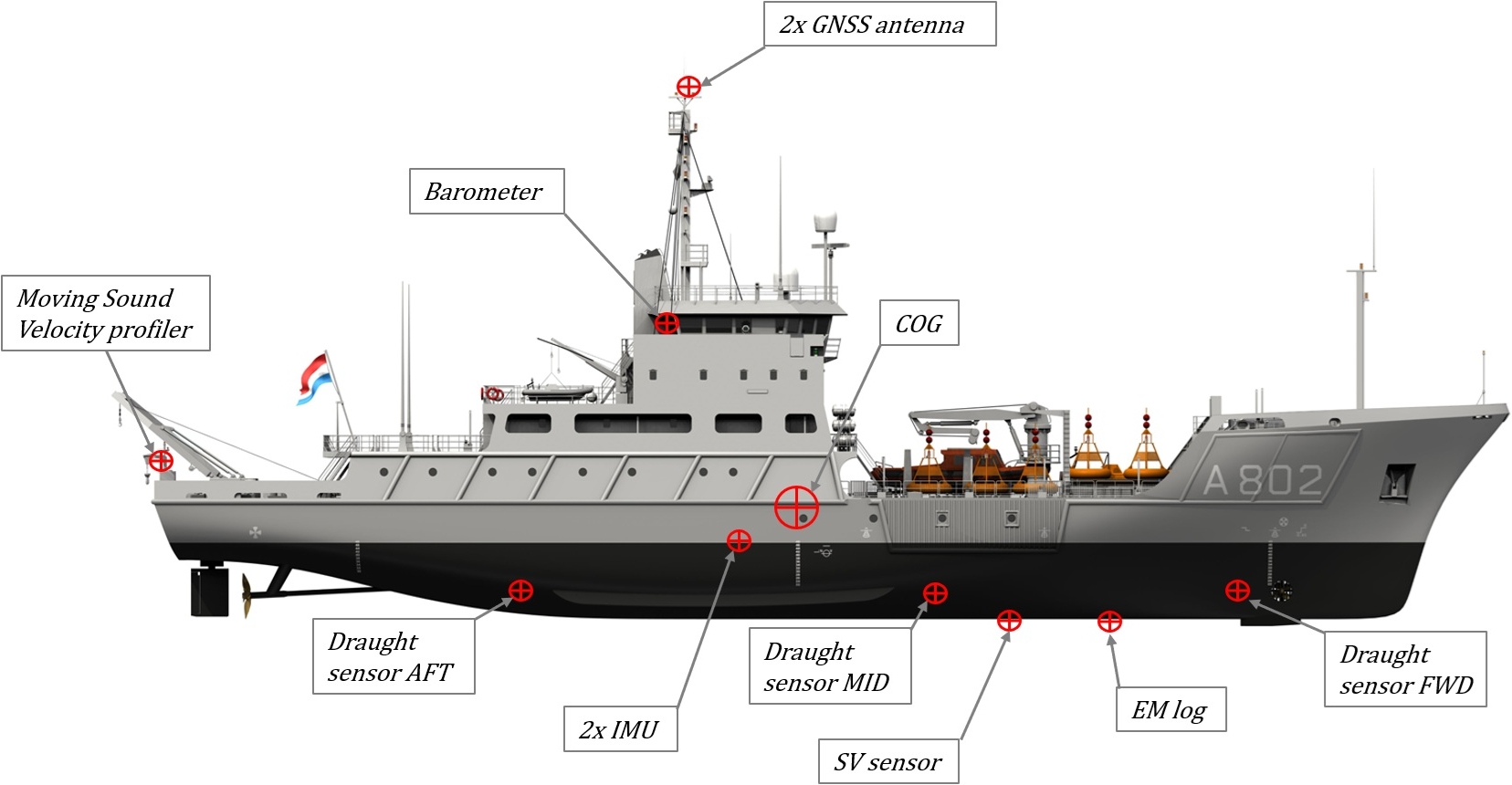
Data was collected aboard HNLMS Snellius (Fig. 2), an 82-metre hydrographic survey vessel. Positioning relied on Trimble SPS855 and Septentrio AsteRx GNSS receivers, with real-time PPP augmentation provided by Fugro Marinestar G4+ (Ligteringen et al., 2014; Tegedor et al., 2017). Two IXSEA OCTANS MkIII MRUs measured vessel attitude and heave, while draught was recorded using a VegaBar 52 pressure system, corrected for atmospheric pressure and density (Chen & Millero, 1977). Squat effects were estimated through a polynomial function based on previous sea trials. All GNSS, draught, and speed measurements were logged at 1 Hz using QINSy data acquisition software.
3.3 Data processing
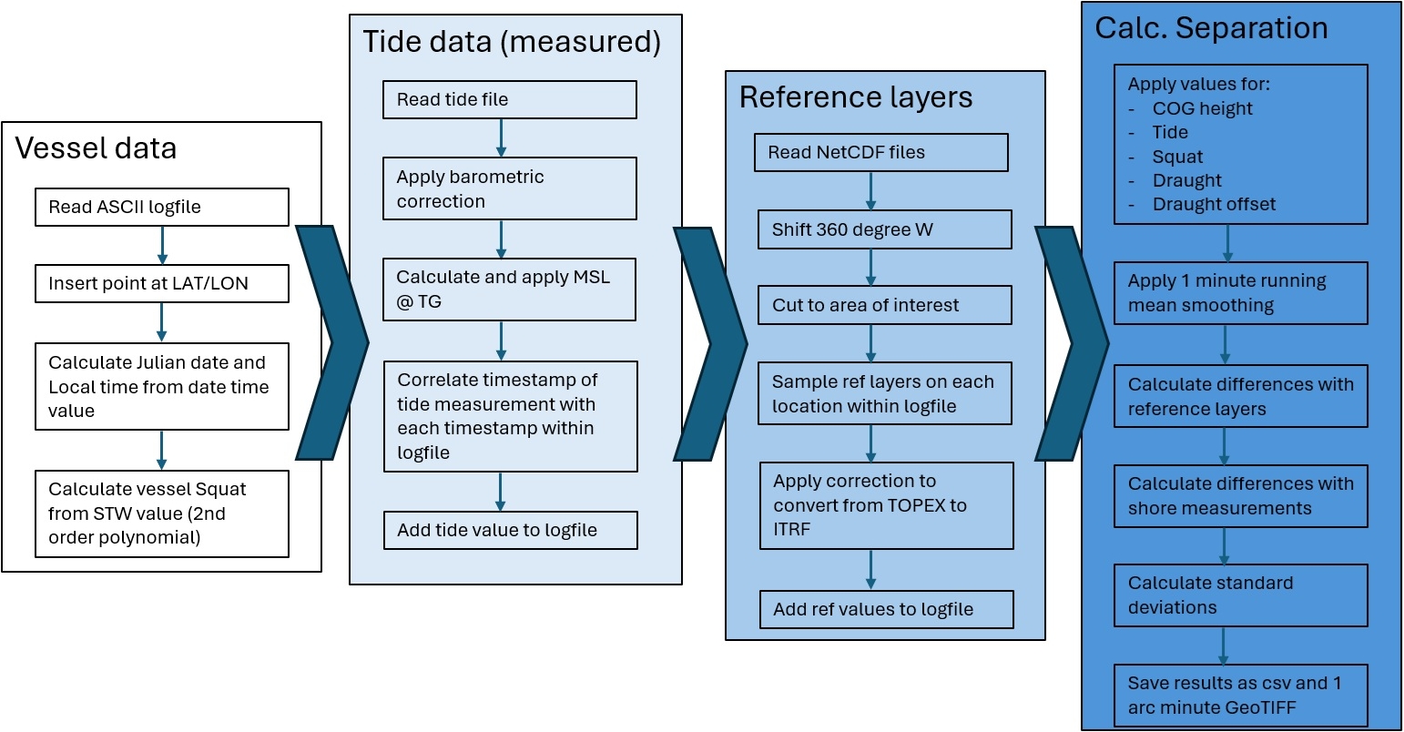
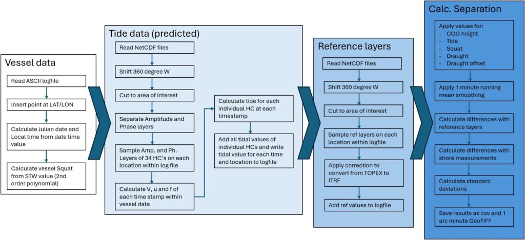
Data processing was conducted through the following steps:
- Satellite-derived MSS models (DTU21, CNES2022) and VORF-global were selected as offshore reference levels (Andersen et al., 2023; Schaeffer et al., 2023; EMODnet, 2017).
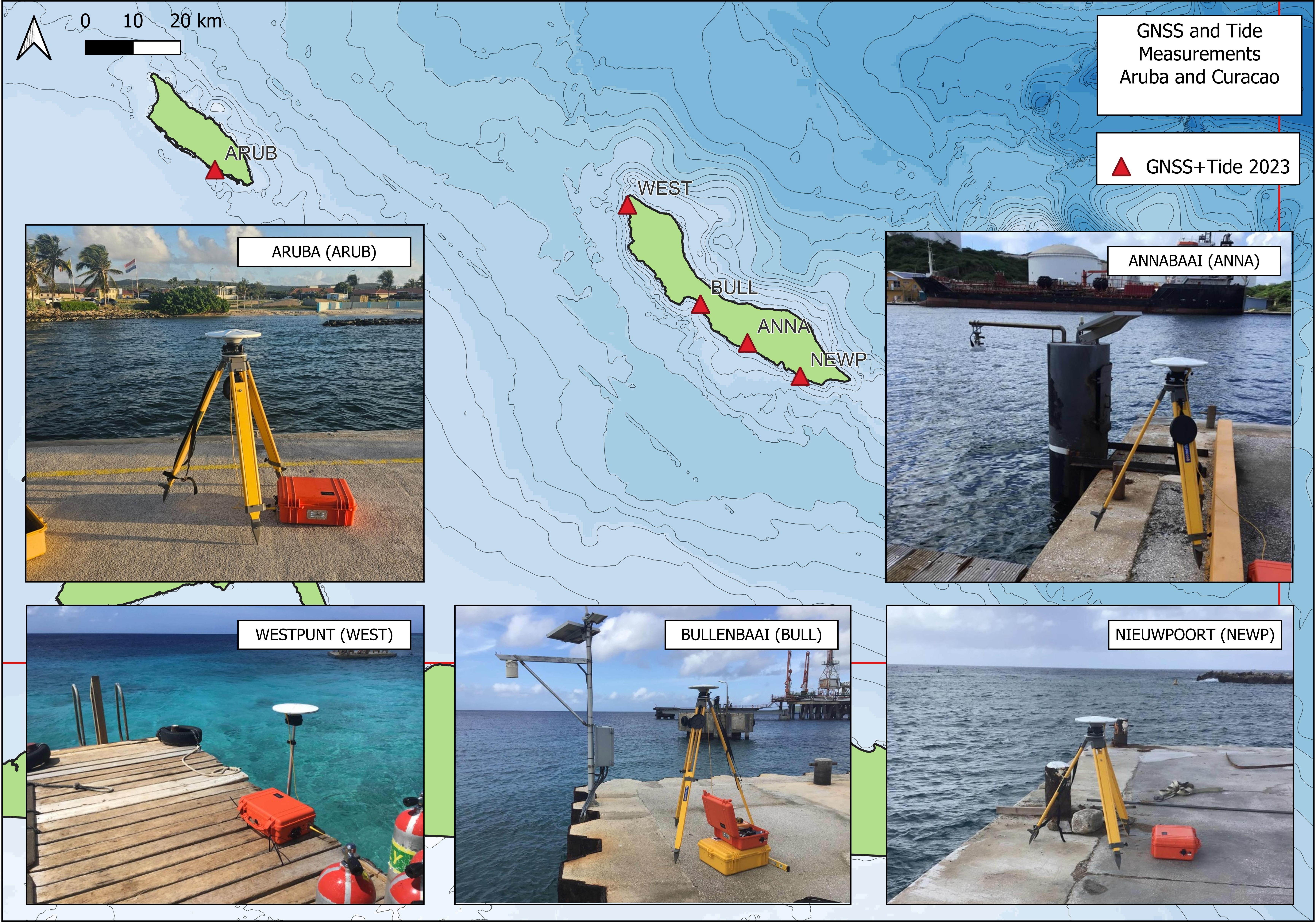
- For coastal separation values, MSL-ellipsoidal separation at five shore stations in Site 1 was determined using static GNSS measurements and processed via Trimble RTX, combined with a 30-day tide series, corrected for barometric variation.
- Tidal validation of the permanent TG at Bullenbaai (University of Hawaii, UHSLC) on Site 1 was conducted by comparing its readings to temporary stations (ARUB, ANNA, WEST, BULL, NEWP). Fort Bay TG on Site 2 served solely as a reference.
- Tidal values at Site 2 were calculated for each vessel measurement using harmonic constituents from DELTARES (2009–2010) and FES2014 (AVISO+), employing the Admiralty calculation method (Glen, 1977).
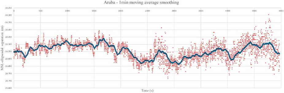
- Offshore MSL values were calculated for Sites 1 and 2, accounting for vessel motion, draught, and squat. A 60-second moving average filter was used to reduce noise and residual vessel motion artefacts.
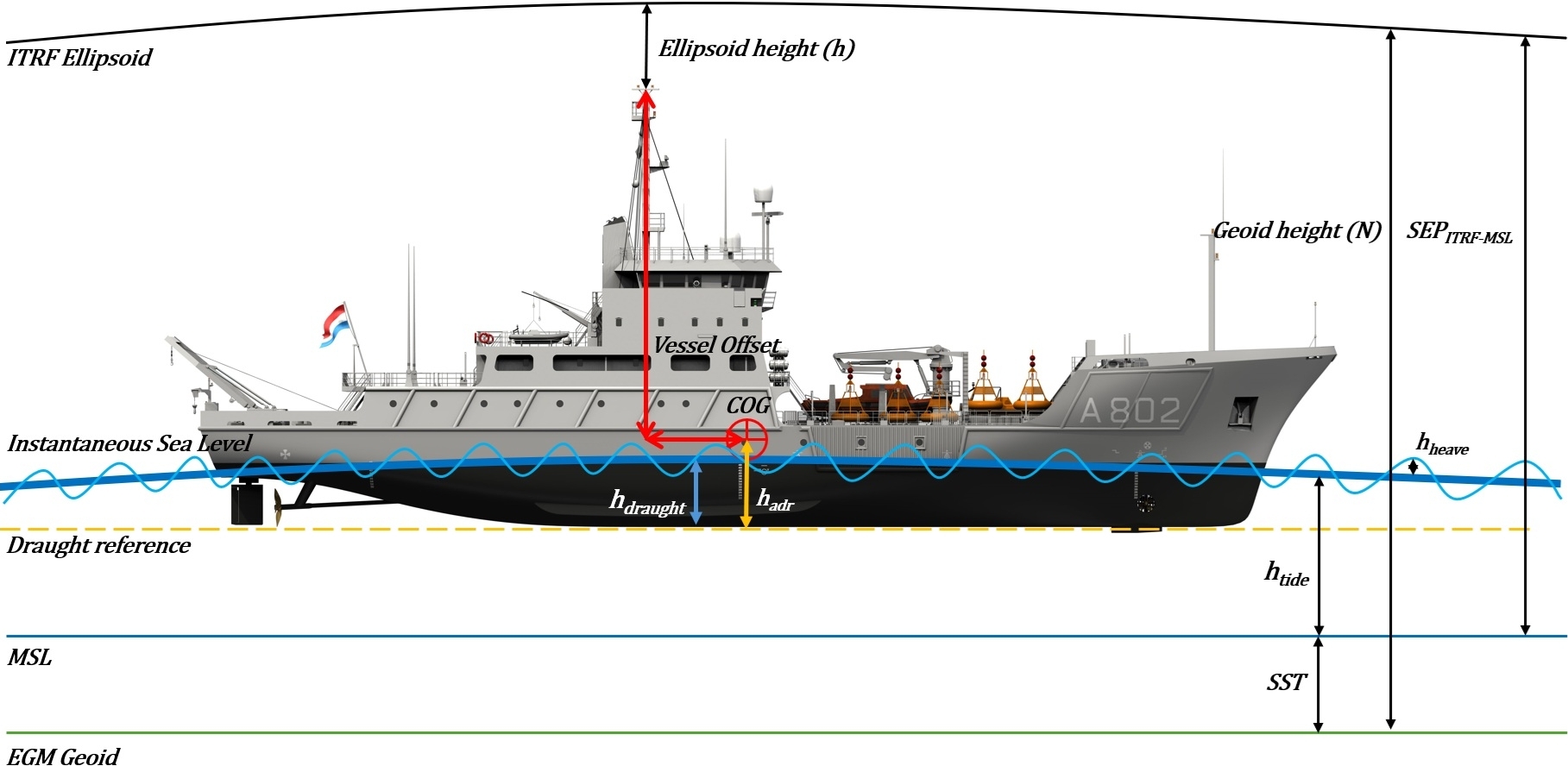
- Separation was calculated at each datapoint using the following formula
SEPMSL-ITRF = hcog – hadr + hdraught + hsquat – htide (1)
where:
SEPMSL-ITRF: separation between MSL and ITRF ellipsoid (GRS80)
hcog: measured ellipsoidal centre of gravity (COG) height
hadr: fixed COG to draught reference offset
hdraught: draught
hsquat: dynamic settlement of the vessel as a function of vessel speed
htide: tidal level i.r.t. MSL - The instrument and methodological uncertainties were modelled to establish a priori confidence intervals for the established separation.
- For comparative analysis, the derived MSL values were compared with satellite MSS and VORF models to assess the a-posteriori accuracy of vessel-based GNSS-tide methods.

4 Results
4.1 MSS model comparison
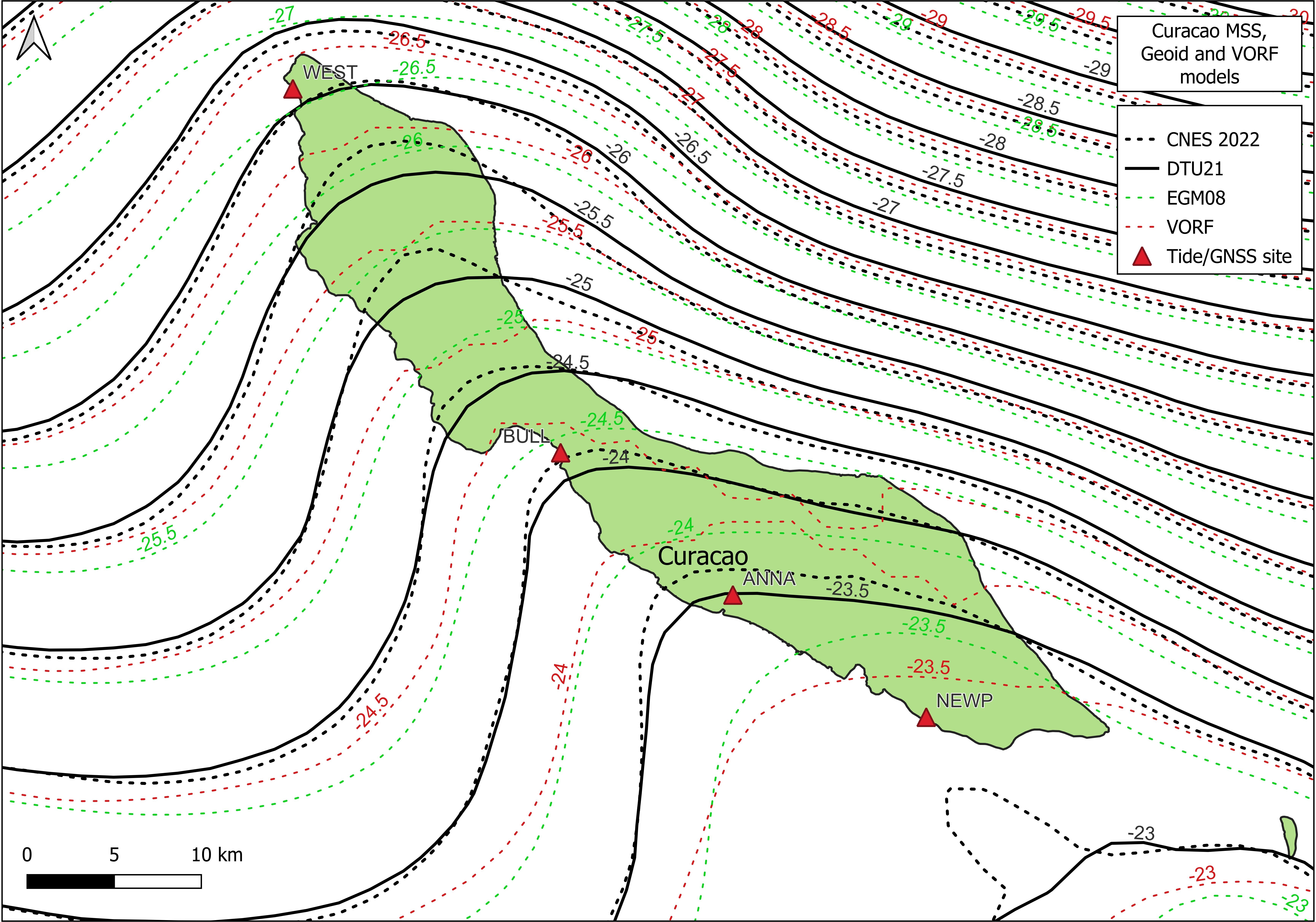
Across Site 1 (Aruba and Curaçao), the DTU21 and CNES2022 Mean Sea Surface models generally show consistent offshore behaviour, although increasing discrepancies are seen in nearshore zones and over land. Along the south-west coast of Curaçao, as well as in terrestrial areas, the model contours diverge, indicating reduced reliability of global reference surfaces in complex coastal environments. In contrast to DTU21, CNES2022 displays a noticeable local deviation near the NEWP location, similar to the contour pattern observed at ARUB. Over the land areas of Aruba and Curaçao, VORF global shows prominent artefacts, highlighting its limitations for coastal island applications. The absence of similar artefacts in the VORF global model near Saba is probably due to the limited land surface, which lessens its impact on satellite altimetry processing (Andersen et al., 2023).
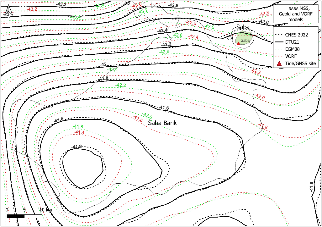
At Site 2 (Saba and Saba Bank), all evaluated reference models exhibit more uniform spatial behaviour, but with consistently larger vertical offsets compared to Site 1. The difference between DTU21 and both EGM08 and VORF global is approximately 35–40 cm, significantly exceeding the inter-model differences observed in the Leeward Islands. Differences between VORF global and the MSS models at Site 2 are comparable to those observed near Aruba, but slightly smaller than those near Curaçao.
Overall, the MSS comparison reveals a clear site contrast: Site 1 is dominated by nearshore and land-related artefacts, while Site 2 exhibits smoother spatial patterns but larger systematic offsets between global models.

4.2 Shore-based separation values
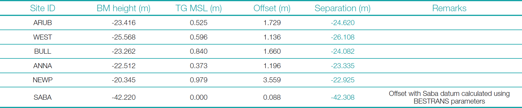
At Site 1, coastal Mean Sea Level-ellipsoidal separation values were calculated at five shore stations using static GNSS measurements processed with Trimble RTX, combined with a 30-day tide series corrected for barometric variation. These shore-based values offer a well-constrained local reference for validating vessel-derived separation values in the Leeward Islands.
At Site 2, the ellipsoidal height of the Fort Bay tide gauge was established using ITRF to Saba Datum transformation parameters (Lesparre et al., 2023), with an approximate uncertainty of 10 cm due to limited benchmark availability. Therefore, shore-based validation at Site 2 relies on a single reference point, which has a higher associated uncertainty than those at Site 1.
4.3 Tide prediction and validation
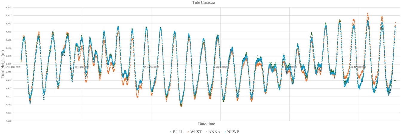
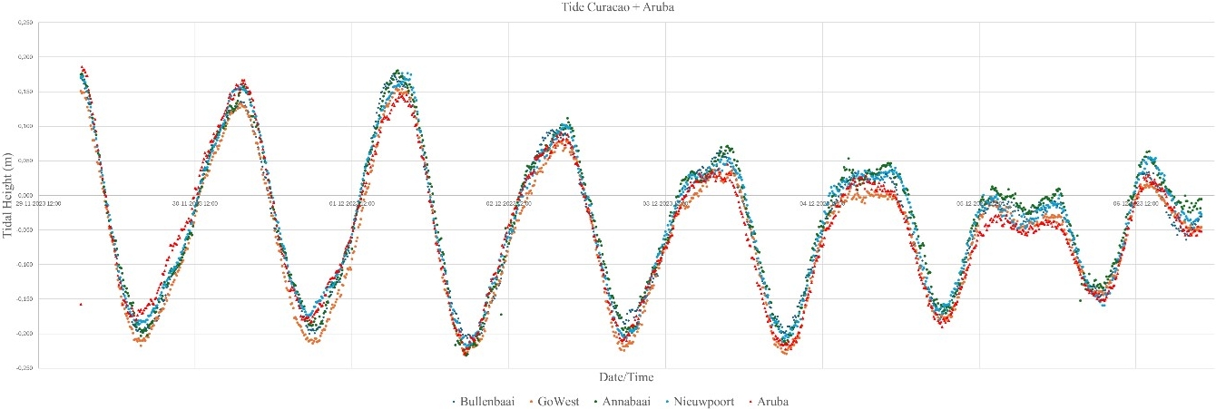
At Site 1, the permanent tide gauge at Bullenbaai was validated by comparison with multiple temporary stations (ARUB, ANNA, WEST, BULL, and NEWP), providing confidence in the shore-based tidal reference used for separation analysis.
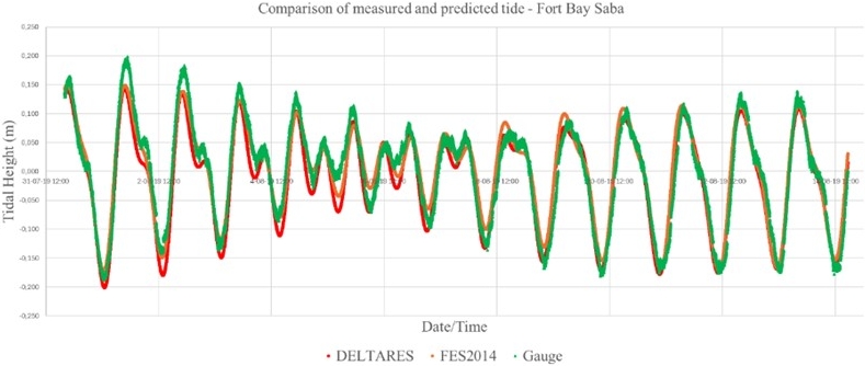
At Site 2, where predicted tides are required, comparison of measured and predicted tides at Fort Bay shows only minor differences between the DELTARES and FES2014 harmonic constituents, with the largest discrepancies occurring in long-period components. Despite limitations in resolving long-period variability, FES2014 exhibits slightly better agreement with observed tidal records. Application of Glen’s Admiralty method (Glen, 1977) presented computational challenges, which were mitigated through a simplified polygon-based sampling approach applied to the vessel measurement locations.
These results indicate that tidal prediction constitutes a more significant source of uncertainty at Site 2 than at Site 1, where direct gauge-based validation is possible.


4.4 Uncertainty and data quality
The total vertical uncertainty of offshore separation measurements is estimated at 9.2 cm, including GNSS positioning accuracy, MRU performance, tidal zoning, and draught effects. This level of uncertainty aligns with hydrographic survey standards (NOAA, 2021) and matches the performance of existing separation models (Abd Rahman & Md Din, 2020).
Data quality varied within Site 1, with MRU settling artefacts more prominent in the Curaçao dataset due to frequent vessel manoeuvres and variable survey speeds. Applying a 1-minute moving average filter effectively reduced noise and residual motion artefacts, enhancing the stability of the separation time series, while acknowledging a trade-off between noise suppression and spatial resolution (Liibusk et al., 2022).

4.5 Regional and model-based variability
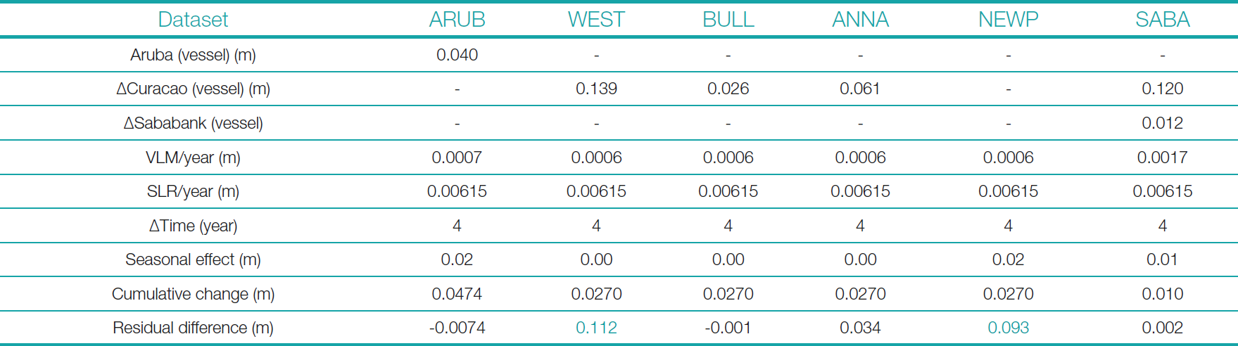
Comparison of vessel-derived separation values with shore-based references shows differences from 1 to 14 cm before geophysical correction. After accounting for Vertical Land Movement (Cadastral authority), Sea Level Rise (Maitland et al., 2024), and seasonal sea level variability (Maitland et al., 2024), residual differences decrease to 0–3 cm at ARUB, BULL, ANNA, and SABA, indicating strong agreement between vessel-based and shore-derived separation values at these locations. Higher residuals at WEST and NEWP remain, suggesting the presence of local systematic effects.
When vessel-derived offshore separation values are compared with global reference models, the closest agreement is observed with DTU21, while CNES2022 shows larger average differences, particularly near Curaçao. In all cases, the global models exhibit higher separation values than those derived from vessel-based observations. Differences between the epochs of MSS model development and the present study, especially regarding the assumed yearly Sea Level Rise, may contribute to these discrepancies (Schaeffer et al., 2023; Andersen et al., 2023). VORF global and EGM08 show significantly larger deviations from both vessel-based and shore-based separation values, highlighting their limitations as vertical reference levels in the Dutch Caribbean.

5 Discussion and limitations
The results show that vessel-based GNSS positioning provides a reliable foundation for determining the Mean Sea Level (MSL)-ellipsoidal separation in the Dutch Caribbean, even in areas with limited geodetic infrastructure. The close agreement between vessel-derived and shore-based separation values, especially after adjustments for Vertical Land Movement (VLM), Sea Level Rise (SLR), and seasonal variations, confirms the methodology’s validity and supports its application in operational hydrographic tasks.
A key outcome of this study is the strong site-dependent contrast observed between the Leeward and Windward Islands. At Site 1 (Aruba and Curaçao), the availability of multiple shore-based tide gauges enabled rigorous validation of vessel-derived separation values. After geophysical corrections, residual differences were reduced to within a few centimetres at most reference locations, demonstrating that vessel-based GNSS can reproduce coastal MSL references with high internal consistency. The remaining higher residuals at specific stations (WEST and NEWP) suggest the presence of local systematic effects, potentially related to site-specific sensor configuration, benchmark stability, or local hydrodynamic influences.
In contrast, Site 2 (Saba and Saba Bank) presents a more challenging operational environment, where validation depends on a single tide gauge reference with higher transformation uncertainty and where predicted tides are necessary. Despite these limitations, the vessel-derived separation values at Site 2 demonstrate comparable agreement with the available shore reference after correction, indicating that vessel-based GNSS remains a feasible approach even in data-scarce offshore settings. This finding is especially relevant for remote island regions where installing and maintaining conventional tide gauge networks is impractical.
The comparison with global reference surfaces further emphasises the benefits of the vessel-based approach. Among the evaluated global models, DTU21 aligns most closely with vessel-derived offshore separation values across both study sites, while CNES2022 shows larger deviations in nearshore zones, especially near Curaçao. The significant differences observed for VORF global and EGM08 highlight their limitations as vertical reference proxies in complex island environments. These discrepancies are consistent with the known sensitivity of global models to coastal altimetry artefacts and variations in model epoch, particularly concerning assumed rates of Sea Level Rise.
Uncertainty analysis shows that the overall vertical uncertainty of about 9.2 cm matches that of current separation models and meets hydrographic survey standards. However, the results also highlight how vessel-based separation estimates depend on vessel dynamics and motion sensor performance. Increased noise and settling artefacts observed during manoeuvring, especially in the Curaçao dataset, emphasise the need for high-quality motion reference units and consistent survey speeds. While temporal filtering effectively reduces noise, it also lowers spatial resolution and cannot entirely counteract sensor limitations in highly dynamic conditions.
Several limitations of the present study should be acknowledged. The reliance on real-time PPP solutions limited access to raw GNSS observations for post-processing, which could otherwise enhance positioning accuracy and consistency. At Site 2, dependence on predicted tides introduces additional uncertainty, especially in long-period tidal components that are not fully captured by existing harmonic models. Moreover, the limited availability of long-term GNSS and tide gauge records restricts the ability to fully characterise local VLM and SLR trends, which are crucial for long-term vertical datum maintenance.
Despite these limitations, the findings demonstrate that vessel-based GNSS measurements offer a flexible and scalable alternative to traditional tide gauge-based vertical referencing. When combined with appropriate environmental corrections and uncertainty assessment, this approach enables the generation of reliable MSL-ellipsoidal separation values in regions where conventional geodetic infrastructure is limited or absent. The results, therefore, support the establishment of a regional network of permanent tide gauges and GNSS stations in the Dutch Caribbean, which would further enhance separation accuracy, improve monitoring of VLM and SLR, and strengthen the link between marine and terrestrial reference frames.
6 Conclusion
This study shows that vessel-based Global Navigation Satellite System (GNSS) positioning offers a practical and reliable method for determining the Mean Sea Level (MSL)-ellipsoidal separation in the Dutch Caribbean, even in areas with limited geodetic infrastructure. By combining legacy vessel-based PPP GNSS data with tidal observations, predicted tides, and satellite altimetry, the approach effectively connects offshore measurements with coastal vertical reference systems.
The results indicate that vessel-derived separation values can match shore-based MSL references within a few centimetres after adjustments for Vertical Land Movement (VLM), Sea Level Rise (SLR), and seasonal variability. This agreement is strongest in the Leeward Islands (Aruba and Curaçao), where multiple shore-based tide gauges enable rigorous validation. At the Windward Islands (Saba and Saba Bank), where validation depends on predicted tides and a single tide gauge reference, the vessel-based method remains consistent within the achievable uncertainty range, confirming its suitability in environments with limited data and operational challenges.
Comparison with global reference surfaces shows that DTU21 aligns most closely with vessel-derived offshore separation values across both study sites. Conversely, CNES2022 exhibits larger nearshore deviations, while VORF global and EGM08 display significant inconsistencies, especially in complex island environments. These results underline the limitations of relying solely on global models for vertical referencing in the Dutch Caribbean and highlight the importance of empirical, region-specific separation estimates.
The total vertical uncertainty of about 9.2 cm meets hydrographic survey standards and aligns with existing separation models. However, the analysis also shows sensitivity to vessel movement, sensor performance, and tidal modelling, especially during manoeuvres and in areas without permanent tide gauges. These issues highlight the need for high-quality motion sensors, stable survey operations, and better access to post-processed GNSS data.
Overall, this contribution demonstrates that vessel based GNSS positioning provides a robust and operationally viable approach for vertical referencing in coastal and island environments where traditional tide gauge networks are sparse or absent. To further improve accuracy and long-term consistency, establishing a permanent regional network of tide gauges and GNSS stations in the Dutch Caribbean is highly recommended. Such infrastructure would enhance monitoring of VLM and SLR, strengthen connections between marine and terrestrial reference frames, and support future hydrographic surveying, coastal development, and climate change impact assessments.
By demonstrating the practical potential of vessel based GNSS for achieving consistent vertical control, this study contributes to improved coastal decision making and supports the development of informed sea level adaptation strategies in the Dutch Caribbean.
References
Abd Rahman, M. F. and Md Din, A. H. (2020). The Development of Continuous Hydrographic Datum Using Geodetic-Based Approaches: A Review. IOP Conf. Ser: Earth Environ. Sci., 540, 012062. https://doi.org/10.1088/1755-1315/540/1/012062
Andersen, O. B., Rose, S. K., Abulaitijiang, A., Zhang, S. and Fleury, S. (2023). The DTU21 global mean sea surface and first evaluation. Earth Syst. Sci. Data, 15, 4065–4075. https://doi.org/10.5194/essd-15-4065-2023
Chen, C.-T. and Millero, F. J. (1977). Speed of sound in seawater at high pressures. The Journal of the Acoustical Society of America, 62, 1129–1135. https://doi.org/10.1121/1.381646
EMODnet (2017). WP2.1: Assess consistency of the existing vertical datum Vertical datums in the European coastal zone. In EMODnet Coastal Mapping – Final Report (Phase 2, version 1.1).
Glen, N. C. (1977). The Admiralty Method of Tidal Prediction. The International Hydrographic Review, 54(1), 14. https://journals.lib.unb.ca/index.php/ihr/article/view/23705 (last accessed 3 April 2026).
Ligteringen, T., Loog, J. and Dorst, L. (2014). GNSS-Based Hydrographic Surveying: clear advantages and hidden obstacles [Conference presentation]. European Navigation Conference on GNSS 2014, Rotterdam, p. 11.
Liibusk, A., Varbla, S., Ellmann, A., Vahter, K., Uiboupin, R. and Delpeche-Ellmann, N. (2022). Shipborne GNSS acquisition of sea surface heights in the Baltic Sea. Journal of Geodetic Science, 12, 1–21. https://doi.org/10.1515/jogs-2022-0131
Maitland, D. O., Taylor, M. A. and Stephenson, T. S. (2023). Investigation of Multi-Timescale Sea Level Variability near Jamaica in the Caribbean Using Satellite Altimetry Records. JMSE, 11, 1499. https://doi.org/10.3390/jmse11081499
Schaeffer, P., Pujol, M.-I., Veillard, P., Faugere, Y., Dagneaux, Q., Dibarboure, G. and Picot, N. (2023). The CNES CLS 2022 Mean Sea Surface: Short Wavelength Improvements from CryoSat-2 and SARAL/AltiKa High-Sampled Altimeter Data. Remote Sensing, 15, 2910. https://doi.org/10.3390/rs15112910
Tegedor, J., Ørpen, O., Melgard, T., Lapucha, D. and Visser, H. (2017). G4 Multi-constellation Precise Point Positioning Service for High Accuracy Offshore Navigation. TransNav, 11, 425–429. https://doi.org/10.12716/1001.11.03.05
Author’s biography
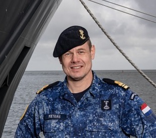
Merte P. J. Peeters is a Commanding Officer of a hydrographic survey vessel in the Royal Netherlands Navy and has been an IHO Category A certified hydrographic surveyor since 2010. His professional experience spans navigation, hydrographic operations, offshore surveying, and geospatial analysis, including roles as a survey party chief and GIS specialist with Boskalis Westminster. He holds a Master’s degree in Advanced Hydrography from MLA College (2025), where his thesis was recognised with the University of Plymouth Academic Partnerships Prize, THS-UKI Alan Ingham award, and second place in the IFHS Student Award. His work focuses on vessel-based GNSS positioning, vertical reference systems, and their application to hydrographic surveying in data-sparse and climate-vulnerable coastal regions.
https://ihr.iho.int/wp-content/uploads/2026/06/IHR-32-1-A05.pdf P9-21