

Preamble
This paper is intended as a response to a Note by Philip Payne, published in The International Hydrographic Review (IHR, https://ihr.iho.int/) in November 2023: Payne, P. (2023). Crowdsourced bathymetry and its use to support resurvey activity in the North Sea region. The International Hydrographic Review, 29(2), pp. 248–253. https://doi.org/10.58440/ihr-29-2-n16
1 Introduction
It is well established that hydrographic surveys with multibeam echosounders (MBES) are the most ideal and preferred way to collect data for the purpose of producing nautical charts. It is also acknowledged that this standard method is constrained in many ways, from survey platforms to personnel to equipment requirements (Masetti, 2020a). Around the world it is uncommon to see a hydrographic authority that has adequately and completely surveyed and mapped their entire area of responsibility (IHO, 2024). Therefore, while the intention here is not to debate whether crowdsourced bathymetry (CSB) can or should be considered “as good as” a hydrographic survey using MBES, this is an invitation for the reader to consider CSB as a supplementary data source which can aid decision making, prioritization and potentially fill data gaps when the well adopted methods do not or cannot.
In the November 2023 edition of The International Hydrographic Review (IHR), the article Crowdsourced bathymetry and its use to support resurvey activity in the North Sea region was published (Payne, 2023). While the article highlighted potential uses and benefits of CSB, it primarily focused on considerations to be taken into account when considering the use of CSB in planning a resurvey scheme in the North Sea.
From the perspective of the chair and vice-chair of the International Hydrographic Organization (IHO) Crowdsourced Bathymetry Working Group (CSBWG), we would like to provide information in response to some of the stated concerns and remind readers that many of the issues raised should either not be taken as general statements or should be recognized as not being unique to CSB data. We would also like to provide the reader with updates about the progress of CSB within the context of CSBWG and a summary on the potential of not just considering, but embracing, CSB as an additional data source by hydrographic offices and other relevant stakeholders. Our intent is to encourage hydrographic offices to continue to pursue their own investigations into whether CSB data may be of benefit to them.
2 Background
As has been described previously in the IHR (Jencks et al., 2021), it was at the 2014 Fifth Extraordinary International Hydrographic Conference, that the IHO recognized that traditional survey vessels alone could not be relied upon to solve data deficiency issues and agreed there was a need to encourage and support all mariners in an effort to “map the gaps”. One outcome of the conference was an initiative to support and enable mariners to collect CSB. A Crowdsourced Bathymetry Working Group1. was established and tasked to draft a new IHO publication, initially published in 2019, to provide best practices for collecting and contributing crowdsourced depth data. Edition 3.0 of the IHO publication B-12 Guidance on Crowdsourced Bathymetry (IHO, 2022a) was approved in October 2022 and included updates such as incorporating feedback from operational use and experience, making the document more “equipment agnostic”, simplifying the document and making it more accessible to all readers (e.g. data collectors, providers and users). The latest edition also takes into account a wider representation of hydrographic authorities, addressing specific issues such as quality assessment of the data and legal considerations in waters of national jurisdiction.
(IHO, 2022a) defines crowdsourced bathymetry as the collection and sharing of depth measurements from vessels, using standard navigation instruments, while engaged in routine maritime operations.
Today, the CSBWG focuses on investigating and highlighting use cases of CSB data, providing guidance on data quality and standards in liaison with the IHO Data Quality Working Group (DQWG) and considering incentives to increase data contributions by mariners. The CSBWG is particularly tasked to work in cooperation and coordination with other IHO bodies, including the 15 Regional Hydrographic Commissions (RHCs) and relevant industry stakeholders, to understand regional perspectives, technical capabilities and to encourage a harmonized approach to data gathering and the resultant datasets. Thanks to the active participation of the CSBWG members, a comprehensive work plan has been established (CSBWG, 2023) and efforts are being put towards building a bridge between stakeholders needs, identified challenges and the operationalisation of CSB supported by the development of open source tools.
3 CSB as part of the modern hydrographic toolbox
It is understood within the hydrographic community that the fast evolution of technology is creating the need to redefine the role of the hydrographers, cartographers and managers of hydrographic authorities around the world. This is not just limited to upgrading personnel skills, but also to changing the ways in which data is treated and processes and organizations are managed (Foroutan et al., 2022). Part of this transformation requires thinking out of the box, considering alternative methodologies, diversifying data sources and engaging in new partnerships. We would like to invite the reader to embrace this reality whenever considering testing or using non-traditional data sources such as CSB.
Furthermore, hydrographic offices around the world are today expanding their scope to more than just safety of navigation. This is reflected in the vision and mission statements of many offices and authorities, which include supporting scientific research and contributing to a more sustainable use of the oceans (e.g. Directorate of Hydrography and Navigation of Peru, Canadian Hydrographic Service). There are also hydrographic offices which contribute nationally and internationally to the prediction and damage mitigation of tsunamis and sea level rise. Therefore, when considering new data sources, it is important to evaluate how this data can contribute to the overall mission of a hydrographic authority, rather than determine only whether a specific sounding will qualify to be displayed in a nautical chart.
It is the ultimate responsibility of each organization to decide whether CSB should be considered as a source of data. In addition to the well explained use case for seabed or feature monitoring (Payne, 2023), we would like to provide a few additional examples of the potential benefits of CSB for the consideration of such organizations.
3.1 Recognizing the value of CSB in uncharted areas
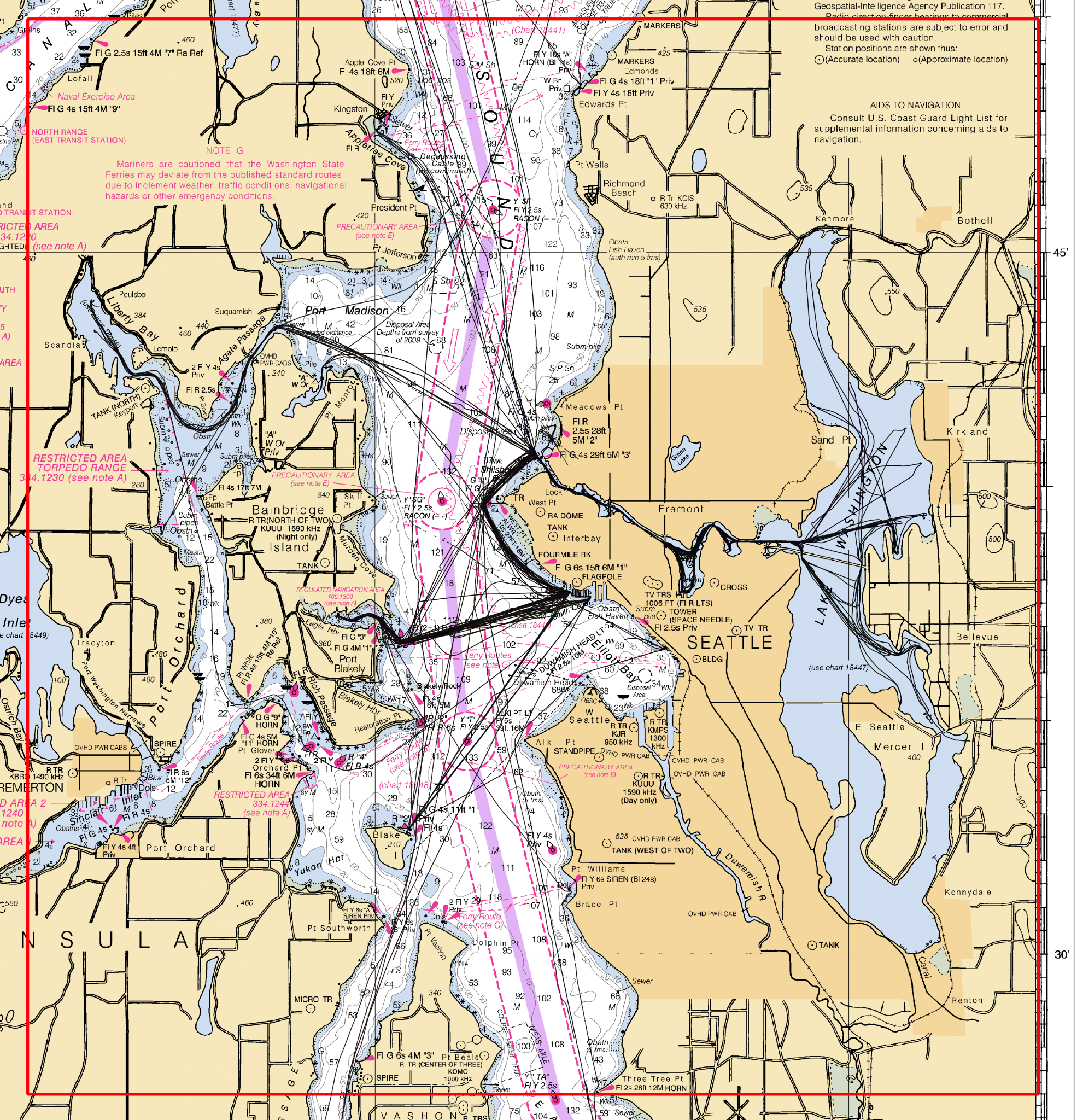
CSB data collected in areas routinely visited by vessels where hydrographic surveys do not reach is typically the first use case that is considered. Fig. 1 shows an example of a considerable amount of CSB data collected beyond the extents of a hydrographic survey. Given that this data was collected by one or more vessels conducting their routine maritime operations, the value of increasing the information provided in the existing charts is clear, especially when there is evidence that the uncharted areas are frequently transited.

3.2 Considering CSB in chart adequacy assessments
In heavily used maritime areas of the world, where chart information is vast, CSB also has the potential to make a significant contribution. These data can be used to identify previously uncharted features (Fig. 2), assist in verifying charted information and confirm whether charts are still appropriate for the latest traffic patterns. As described by Calder (2021), increased number of observations can significantly contribute to increasing the quality and value of CSB data (Fig. 3).


3.3 Improving the general knowledge of the seabed
In parts of the coastal world where the nature of the seabed may be ever changing, the advantage of CSB data would most certainly be in the identification of potential change which could assist in the prioritization of surveys (Fig. 4). If pockets of these regions have to be lower prioritized due to resource constraints, CSB can help in the identification of potential change. Making this data and derived products available to the public can also support a wide range of environmental, marine and oceanographic research, specially where a continuous digital model of the seabed is more important than reaching high accuracies.

4 An asset does not (necessarily) equate to a replacement
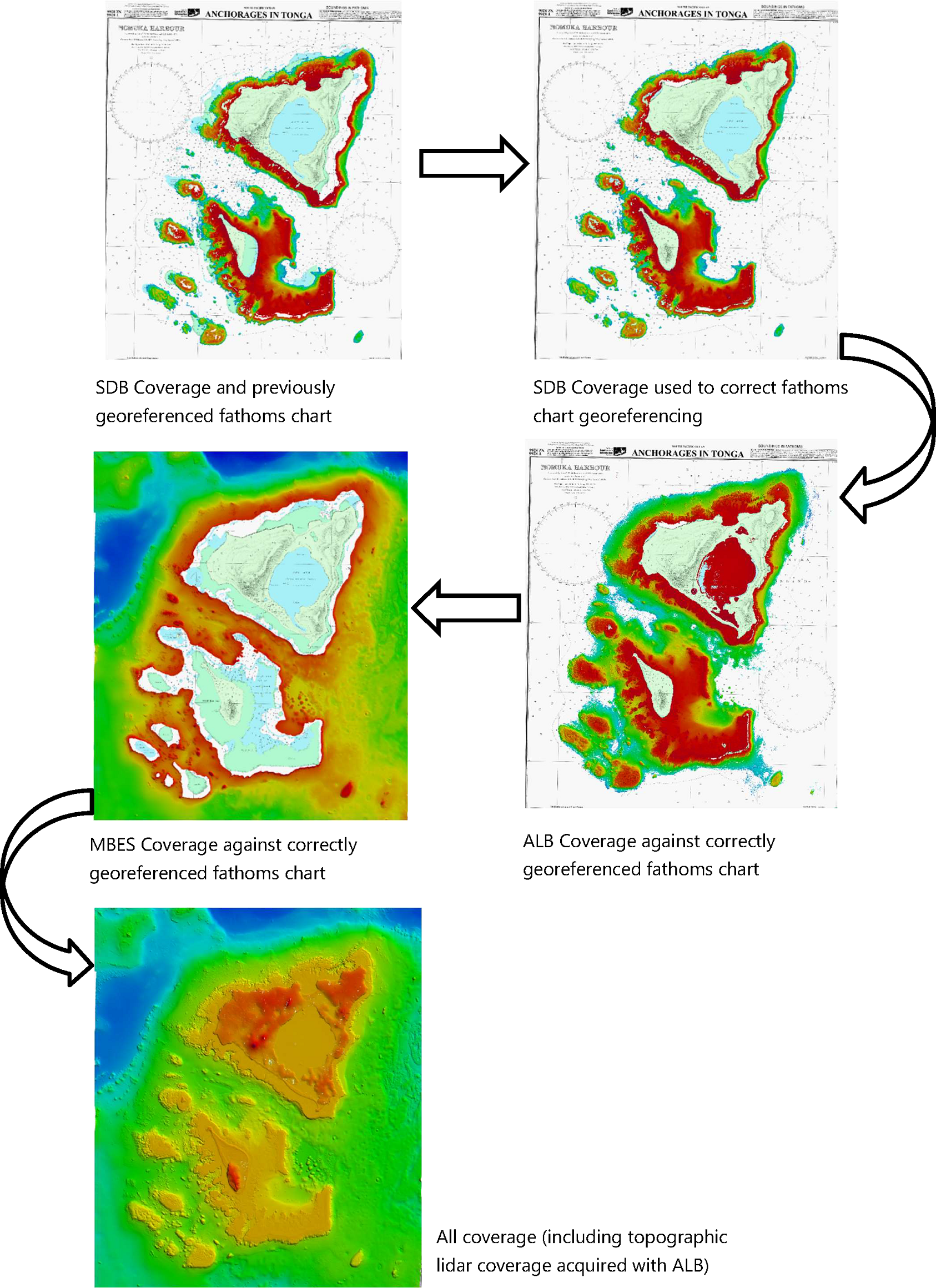
One can easily compare the adoption of CSB to that of LiDAR (light detection and ranging) and satellite derived bathymetry (SDB). These methodologies also provide an alternative for, or addition to, bathymetric surveys in areas where traditional methods such as acoustic-based hydrographic surveys are missing, historically lower prioritized by hydrographic authorities or simply too expensive to conduct due to the inefficiency of MBES in extremely shallow areas. Despite the facing of some barriers at the beginning, these data acquisition methods have now gained extensive popularity. In many cases LiDAR is now accepted as a way to deliver high accuracy S-44 compliant surveys (Cooper, 2021), with the added benefit of also providing a continuous model for land and water. The ability for SDB to detect shoals at a very low cost is also evident and SDB datasets have been commissioned by hydrographic authorities around the world, achieving results which can meet the standards Category Zone of Confidence (CATZOC) B and C (EOMAP, 2019).
As demonstrated in Fig. 5, it is relevant to note, that neither SDB or LiDAR have become a replacement to multibeam, rather it is the combination of methods which can optimize resources and capabilities of a hydrographic authority in fulfilling their primary task to enable safe navigation (Cooper, 2021).
5 But is the data any good?
Hydrographic offices and authorities have always accepted observations from mariners to update their charting area of responsibility. Typically, these are marked “position doubtful”, “existence doubtful”, or the local equivalent, to indicate some level of assessment. There is also an established process for mariner reporting: “Hydrographic Note” in some jurisdictions. The use of modern CSB is not, fundamentally, different from this in quality, in fact, one could argue it is better. Instead of one mariner saying “depth here is 10 m”, theoretically one might have dozens of mariners supplying data consistently reporting the same value. This section provides an overview on accuracy, suitability and quality of CSB data, inviting the reader to consider how to use CSB based on the assessment of those three points.
5.1 Accuracy
The concern around the accuracy of CSB soundings is often raised, and for good reason. Uncontrolled CSB is unlikely to account for offsets and other corrections that would be expected for hydrographic data. However, this situation is not uncorrectable. Vertical offsets and approximate sound speed can often be estimated and corrected for, and has been shown to then match calibrated authoritative data quite well (Klemm & Krabiel, 2023).
Today, the majority of CSB data within the IHO framework is collected with single beam sounders. As explained in Fig. 6, this reduces the problem of resolving for the position and depth of the ensonified seabed to a simple georeferencing equation. As done with any other depth data, having a good understanding of the different error sources can enable the quantification of the uncertainties associated with the determination of position and depth.

If CSB data can be assessed and its accuracy can be calculated, there should be no judgment to which data collection method was used. Whenever the highest orders of S-44 have to be met, the right equipment should be chosen and the finest attention paid to the procedures by the experienced hydrographer. However, deploying such a setup for mapping an area which does not require the highest standards would be excessive and inefficient, and this is why some areas are down-prioritized with respect to others by hydrographic authorities.
As explained by Calder et al. (2020) and Masetti et al. (2020a), implementation of trusted CSB networks under the supervision of the competent authorities can significantly improve the chances of CSB data to qualify for appearing in nautical charts. Fig. 7 shows how data credibility and “chartability” is not just a function of the method used, but also depends on the level of involvement of competent agencies such as hydrographic authorities.

5.2 Suitability
Another concern is around the suitability of CSB data in nautical charting. For example, the North Sea Hydrographic Commission (NSHC) Resurvey Working Group (RSWG) examined and concluded that CSB was not suitable for charting in many areas of the NSHC area (Payne, 2023). While the article made it clear they were referring only to the North Sea, we would like to stress that what might be ruled as unsuitable for one region, may very well be suitable for another. In fact, other hydrographic authorities, such as the Canadian Hydrographic Service (CHS) and the National Oceanic and Atmospheric Administration (NOAA) have been exploring the use of CSB data for years and have provided several positive examples (Jencks, et al., 2021; Klemm & Krabiel, 2023).
Industry is also recognizing the power of CSB. DockTech Ltd. (Tel Aviv-Jaffa, Israel) offers a real-time status of waterway conditions and is demonstrating that in harbors, one of the most critical navigation areas, port operators, pilots and mariners find CSB data a useful addition to their official navigation products (Grinker et al., 2022).
5.3 Data Quality
Data quality is not an inherent quality of a specific methodology or equipment used to collect the data. Hydrographers know that each dataset is unique and needs to be assessed independently. Equipment, experienced operators, and good procedures make the three elements which will ultimately constrain the quality of a specific dataset (IHO, 2022b).
All types of externally sourced surveys present a challenge, and it is still today a work in progress to have charting authorities fully embrace alternative data sources even, for example, multibeam surveys from scientific cruises. While it is true that this type of data may lack some of the essential elements of quality assurance as defined by S-44 (people, procedures, equipment), the gap between the quality of such surveys and the ones planned for safety of navigation has significantly been narrowed. Today some hydrographic authorities have begun to embrace externally sourced data and include it in their products, while others are working on the right procedures to make this happen.
CSB is unlikely to ever reach the uncertainty and quality achieved by professionally collected data. However, in the phrase “best available data” the key word is “available”. When a specific area is covered by volunteer soundings only, a charting authority may consider using this data, with appropriate warnings, rather than leave an area marked as unsurveyed or inaccurate (Fig. 8).

Metadata is critical to the understanding of any dataset. To allow for an assessment of the quality of the data, it is important to document certain additional information together with the data. This is why we strongly encourage active and potential
SDB Coverage used to correct fathoms chart georeferencing data collectors to provide as much extra information as they can (e.g., offsets between global navigation satellite system (GNSS) and echo sounder, type of corrections applied, if any, etc.). The metadata associated with a data set provides valuable supporting information relating to how the data collection was performed and enables appropriate processing, corrections and an informed assessment of the data quality to be made. The CSBWG recommends the review of B-12, specifically Chapter 3: Data & Metadata (IHO, 2022a, pp. 22–29) and Chapter 4: Data Quality Assessment (IHO, 2022a, pp. 30–33), which describe metadata requirements, suggested metadata, and delve into data quality concepts like uncertainty and data consistency. The guidance document also discusses how to provide feedback and suggestions to the CSB data contributor for improving future contributions.
The latest edition of S-44 also includes a matrix, which allows for the classification of any data at a more granular level (IHO, 2022b). This is meant as a tool for the hydrographers to assess the quality of the data beyond the S-44 Order, and to allow for alternative data sources, which might not fully comply with a specific S-44 order, to be assessed in a standardized way. It is encouraged to use such a table to communicate the quality of CSB data, which ultimately will provide the input to decide what the specific data can be used for.
Once the data has been assessed and its quality can be defined in terms of the IHO S-44 matrix, it can be considered whether this data is appropriate for use in a nautical chart. Using the CATZOC table (Fig. 9) the competent authority can estimate if the data is compatible with a specific Zone of Confidence (ZOC), and then decide whether it should be used in the nautical chart (IHO, 2020). As stated by DQWG (2019), “Good data quality does not mean that the quality of the data has to be good. It means that the end user is well informed how good the data is.”

6 Resource considerations
It is a fact that the ever increasing size of a global fleet contributing CSB data can translate to an unpredictable amount of new data, and therefore there is much outspoken concern from hydrographic authorities about becoming quickly overwhelmed. Although this concern is valid, it should not be used as the main argument to systematically dismiss CSB data, but rather as an incentive to optimize and customize workflows that are more appropriate for this purpose. Instead of insisting to fit this data into an existing system, designed to manage different types of data, the way forward is designing specific workflows, based on the same principles and good practice that we apply for any other data source, but customized to fit CSB. Following this trend, many are already developing new tools and processes to assist hydrographic offices, industry and the greater community (for e.g. Debroisse, 2023; Masetti et al., 2020a; Klemm & Kraibel, 2023; Grinker et al., 2022; Salaudeen, 2023). The evolution of these tools, and the needs that are trying to be met, are topics of every CSBWG meeting.
One example is a CSB Processing Tool, developed by NOAA’s Office of Coast Survey. Though it is currently a simple and preliminary solution, it is an important step in unlocking the full potential of CSB data. The script and source-code can be accessed from GitHub2. , and the tool is also distributed through NOAA’s Office of Coast Survey’s Pydro Tool Suite, which is a collection of tools meant to streamline and automate the hydrographic workflow. Both are free and open to the public (Klemm, 2023).
The CSBWG is actively encouraging community-led projects to develop best-in-class “community vetted” algorithms in open-source projects that will support these processes in the future. Much of this work has been published (Calder, 2021; Grinker et al., 2022; Salaudeen, 2023) and we encourage the community to read more about it.
In addition to technology, the skills of the (future) hydrographer and cartographer are constantly being re-defined. The emphasis on data management within hydrographic authorities is evidence of this and having alternative data sources as part of their workflow is something that takes time and effort. We must all be cautious of becoming short-sighted and resist discounting a specific data source simply based on its definition or the volume of the task as to ensure we do not limit the potential for the benefits associated with wider observation of the seabed depths.
Finally, we acknowledge that activities related to CSB data collection and use will likely require resources and funding. However, professional surveyors, vessel time, echo sounders, positioning systems and data management infrastructures all require significant investment. The cost to collect CSB data ranges between free to minimal. Currently The Nippon Foundation GEBCO – Seabed 2030 provides free data loggers and support to those willing to contribute data to the project. The resources and expertise needed to process CSB data are already available within hydrographic authorities. A cost-benefit analysis would be the most appropriate way to decide whether a specific authority should include CSB data in their workflows.
7 Currently available CSB datasets
Over the last several years, contributions of CSB data to the IHO Data Centre for Digital Bathymetry (DCDB) has grown significantly (Fig. 10). The IHO DCDB Viewer (ncei.noaa.gov/maps/iho_dcdb/)3. allows the public to discover and download these data. At the same time, most data are concentrated around just a few areas. It should be noted that this is not necessarily because of a lack of data being collected (though that might certainly be one reason), but that it also reflects coastal States responses (or lack of responses) to Annex B IHO Circular Letter (CL) 11/20194. and to the questionnaire in Enclosure to IHO CL 21/20205.
If we were to focus on just one region, for example the North Sea (Fig. 11), we would observe a significant amount of CSB data off the coast of Norway, some off of Germany, Belgium and the Netherlands, and data within the exclusive economic zone (EEZ) of Sweden. This is the result of both data contributions within the region, but also of the positive response to the circular letters that the States provided. The lack of discoverable data along the coastlines of Denmark and France is because these offices have requested the ability to pre-approve data within their waters of national jurisdiction before it is made publicly discoverable. The IHO DCDB has developed the necessary tools and interface to allow for countries with such a requirement to undertake the review. Denmark and France have been involved in beta testing and have provided valuable feedback to DCDB. Neither the United Kingdom nor Ireland have provided replies to the circular letters, therefore data collected within their areas of national jurisdiction are not allowed to be made discoverable.
The list of all coastal States that have replied positively to the questionnaire in Annex B to IHO CL 11/2019 and to the questionnaire in Enclosure to IHO CL 21/2020 can be found online6.
It should also be acknowledged that the responses to IHO CL 11/2019 and 21/2020 currently total 34 coastal States. We are optimistic that this number will grow, especially when coastal States who have responded positively to the circular letters encourage others to do the same and strive to work together to share, not only data, but also lessons learned and approaches to data collection, processing and application of CSB.


8 Conclusion
We would like to thank the editor of the IHR for the opportunity to respond to “Crowdsourced bathymetry and its use to support resurvey activity in the NorthSea region” published in November 2023 (Payne, 2023). We would also like to thank those authors for acknowledging the potential uses and many benefits of CSB and also for taking part in a much-needed dialogue about the concerns of hydrographic authorities regarding CSB data, as it allows for the CSBWG to address such concerns.
As the IHO effort to encourage the acceptance of CSB and to provide guidance and structure on how to collect and use CSB data is still quite new, we understand and would expect that it will take time until this data source is fully adopted by hydrographic authorities.
It is well known that despite the great work that hydrographic authorities around the world are doing to provide a service, there are a number of unofficial products, essentially populated by CSB, that are distributed and widely used by mariners. The use of unofficial charts over official ones will continue to increase unless hydrographic authorities get involved in considering the application of CSB. As long as these services remain unofficial and unsupervised by qualified hydrographers and cartographers, the full potential of CSB will not be unlocked, while a large percentage of mariners worldwide will continue to demand products in areas outside of the priorities of the local hydrographic authorities.
As data volumes and public interest grow, we are hopeful that hydrographic authorities and academic institutions will take on these issues, perform analyses, create products, etc. In the meantime, the IHO DCDB is always looking for feedback to enhance the way CSB is served to the public.
While the collection of bathymetric data by mariners is not new, we acknowledge that the hydrographic community is still in the early stages of understanding and implementing CSB within the IHO framework and that much of what has been written is about potential. However, in a world where our global seafloor is still only 25 % mapped with publicly available data (GEBCO Bathymetric Compilation Group, 2023) and our coastal waters only 50 % charted (IHO, 2024), we believe it is a great disservice to discourage the consideration of any bathymetric data type, especially one that is readily available to everyone.
The IHO strongly encourages all coastal States to permit the CSB data collected within their waters of national jurisdiction to be made publicly available and to work with others in the field who are currently developing ways and ideas to best use these data, whether for nautical charting or other purposes. Healthy skepticism is good and needed, especially when safety of navigation is involved. However, we encourage all hydrographic authorities to consider the use and application of these data on their own.
We also encourage all hydrographic authorities to attend future CSBWG meetings where their concerns, suggestions, and work would be most welcome to discuss. The next IHO CSBWG, hosted by the IHO, will be 23–25 April 2024, followed by an IRCC Workshop on Crowdsourced Bathymetry (CSB) on 26 April. Please also consult our website1 for information on future meeting dates.
References
Calder, B. R. (2021). Estimating Observer and Data Reputation in Mariner Volunteered Bathymetry. The International Hydrographic Review, 25, pp. 77–96. https://ihr.iho.int/articles/estimating-observer-and-data-reputation-in-mariner-volunteered-bathymetry/
Calder, B. R., Dijkstra, S. J., Hoy, S., Himschoot, K. and Schofield, A. (2020). A Design for a Trusted Community Bathymetry System. Marine Geodesy, 43(4), pp. 327–358. https://doi.org/10.1080/01490419.2020.1718255
CSBWG (2023). Crowdsourced Bathymetry Working Group Work Plan 2023. Crowdsourced Bathymetry Working Group, Inter-Regional Coordination Committee, International Hydrographic Organization. https://iho.int/uploads/user/Inter-Regional%20Coordination/CSBWG/MISC/CSBWG_WorkPlan_13December2023.pdf (accessed 1 April 2024).
Cooper, B. (2021). Effectively Mapping and Charting of Remote Locations with Satellites, Lasers and Acoustics. The International Hydrographic Review, 26, pp. 61–83. https://ihr.iho.int/articles/effectively-mapping-and-charting-of-remote-locations-with-satellites-lasers-and-acoustics/ (accessed 1 April 2024).
Debroisse, P. J., (2023). Towards Automation of Volunteered and Authoritative Bathymetric Data Comparisons [Master’s thesis, University of New Hampshire]. https://ccom.unh.edu/sites/default/files/publications/Debroisse_Thesis_Final.pdf (accessed 1 April 2024).
DQWG (2019). Combining S-101 and S-102 and definitions of depth [presentation]. Data Quality Working Group, S-100 Test Strategy Meeting 7, Monaco, 23–26 September 2019. Hydrographic Services and Standards Committee, International Hydrographic Organization. https://legacy.iho.int/mtg_docs/com_wg/S-100WG/TSM7/TSM7_2019_5.5_DataQualityV1.pdf (accessed 1 April 2024).
EOMAP (2019). Satellite-Derived Bathymetry in Hydrographic Surveys [presentation]. South West Pacific Hydrographic Commission, 16th Meeting 13–15 February 2019, Niue. https://iho.int/uploads/user/Inter-Regional%20Coordination/RHC/SWPHC/SWPHC16/SWPHC16-16.2-EOMAP.pdf (accessed 1 April 2024).
Foroutan, M., Bhatia S. and Béchard, G. (2022). The Hydrographer of the Future – Reflections on an International Virtual Workshop. The International Hydrographic Review, 28, pp. 172–180. https://doi.org/10.58440/ihr-28-n12
GEBCO Bathymetric Compilation Group (2023). The GEBCO_2023 Grid a continuous terrain model of the global oceans and land. NERC EDS British Oceanographic Data Centre NOC. https://doi.org/10.5285/f98b053b-0cbc-6c23-e053-6c86abc0af7b
Grinker, B., Solomon, S. and Hassin, A. (2022). Evaluation of a Crowd Sourced Bathymetric Approach. The International Hydrographic Review, 28, pp. 158–171. https://doi.org/10.58440/ihr-28-a08
IHO (2020). Mariners’ Guide to Accuracy of Depth Information in Electronic Navigational Charts (ENC) (1st ed.). IHO Special Publication S-67, International Hydrographic Organization, Monaco. https://iho.int/uploads/user/pubs/standards/S-67/S-67%20Ed%201.0.0%20Mariners%20Guide%20to%20Accuracy%20of%20Depth%20Information%20in%20an
%20ENC_EN.pdf (accessed 1 April 2024).
IHO (2022a). Guidance to crowdsourced bathymetry (3rd ed.). IHO Publication B-12, International Hydrographic Organization, Monaco. https://iho.int/uploads/user/pubs/bathy/B_12_CSB-Guidance_Document-Edition_3.0.0_Final.pdf (accessed 1 April 2024).
IHO (2022b). Standards for Hydrographic Surveys (6th ed.). IHO Special Publication S-44, International Hydrographic Organization, Monaco. https://iho.int/uploads/user/pubs/standards/s-44/S-44_Edition_6.1.0.pdf (accessed 1 April 2024).
IHO (2024). Status of Hydrographic Surveying and Charting Worldwide. IHO Publication C-55, International Hydrographic Organization, Monaco. https://iho.int/uploads/user/pubs/cb/c-55/c55.pdf (accessed 1 April 2024).
Jencks, J., Wyatt, D., Pratellesi, M. and Wills, P. (2021). A Commitment to Crowdsourced Bathymetry Citizen Sourced Data. The International Hydrographic Review, 26, pp. 119–126. https://ihr.iho.int/articles/a-commitment-to-crowdsourced-bathymetry-citizen-sourced-data-help-reveal-the-deep-and-share-your-data/ (accessed 1 April 2024).
Klemm, A. R. (2023). Introduction to Crowdsourced Bathymetry: The Power of Community. Medium. https://medium.com/@anthony.klemm/introduction-to-crowd-sourced-bathymetry-the-power-of-community-ad941ac20469 (accessed 1 April 2024).
Klemm A. R. and Krabiel T. (2023). Crowd to Chart: Methods and Applications of Crowdsourced Bathymetry in Support of Safe Navigation. US Hydro 2023, March 2023, Mobile, Alabama. https://github.com/anthonyklemm/Crowdsourced_Bathy_Processing/blob/main/Klemm_CSB_USHYDRO23.pdf (accessed 1 April 2024).
Masetti, G., Rondeau, M., Jimenez Baron, B., Wills, P., Petersen, Y. M. and Salmia, J. (2020a). Trusted Crowd-Sourced Bathymetry – From the Trusted Crowd to the Chart. A whitepaper jointly prepared by Danish Geodata Agency and Canadian Hydrographic Service. https://eng.gst.dk/media/9079/trusted-crowd-sourced-bathymetry-from-the-trusted-crowd-to-the-chart20200621.pdf (accessed 1 April 2024).
Masetti, G., Rondeau, M., Jimenez Baron, B., Wills, P., Petersen, Y. M. and Salmia, J. (2020b). “Trusted Crowd-Sourced Bathymetry” Project: From the Trusted Crowd to the Chart [presentation]. 9th Meeting of the IHO Crowdsourced Bathymetry Working Group, Stavanger, Norway, 29 June – 2 July 2020. https://www.researchgate.net/publication/342638911_Trusted_Crowd-Sourced_Bathymetry_Project_From_the_Trusted_Crowd_to_the_Chart (accessed 1 April 2024).
Payne, P. (2023). Crowdsourced bathymetry and its use to support resurvey activity in the North Sea region. The International Hydrographic Review, 29(2), pp. 248–253. https://doi.org/10.58440/ihr-29-2-n16
Salaudeen, I. (2023). Assessing CSB data reliability – Estimating vertical uncertainty of sample CSB data by comparing with reference multibeam data. Journal of Applied Hydrography, 124, pp. 14–19. https://doi.org/10.23784/HN124-03
- https://iho.int/en/csbwg (accessed 1 April 2024).
- https://github.com/anthonyklemm/Crowdsourced_Bathy_Processing (accessed 1 April 2024).
- http://ncei.noaa.gov/maps/iho_dcdb/ (accessed 5 March 2024).
- https://legacy.iho.int/mtg_docs/circular_letters/english/2019/CL11_2019_EN_v1.pdf (accessed 1 April 2024).
- https://iho.int/uploads/user/circular_letters/eng_2020/CL21_2020_EN_v1.pdf (accessed 1 April 2024).
- https://iho.int/uploads/user/Inter-Regional%20Coordination/CSBWG/MISC/B-12_2023_EN_Acceptance_of_CSB_Data_in_NWJ_v7.0.pdf (accessed 1 April 2024).