


A GIS to Prioritize Data Gaps
Abstract
Spanning close to 250,000 km in length, the Canadian coastline is the longest in the world. Collecting and managing data that is required by the Canadian Hydrographic Service (CHS) to produce navigational products for such a vast area can be challenging. Despite CHS products covering the full extent of Canadian waters, gaps in the data persist. To prioritize these gaps, CHS has developed a Geographic Information Systems (GIS) tool, the CHS Priority Planning Tool (CPPT). The derived output of the CPPT helps prioritize the areas that pose the highest risk to navigation.
1. Introduction
Under the authority delegated to Fisheries and Oceans Canada (DFO) under the Oceans Act, the Canadian Hydrographic Service (CHS) is responsible for providing hydrographic products and services to ensure safe, sustainable, and navigable use of Canada’s waterways. At over 243,700 km, Canada has the longest coastline in the world, with navigational waterways measuring approximately 7.1 million square kilometers (DFO, 2008). To cover Canada’s vast water extent, over one thousand nautical charts and hundreds of publications are required. Although CHS products cover all navigational waterways, there are still gaps in data, especially in the more remote areas of the country like the Arctic.
The dynamic nature in of some of Canada’s waters, as well as environmental conditions such as ice and wind, are crucial factors that contribute to the challenges of acquiring surveyed data in navigable waterways. It is important for CHS to prioritize survey gaps in key navigational areas since it could take years to acquire adequate survey data everywhere. Adequate survey can be defined as survey Category Zone of Confidence (CATZOC) coverage level A or B and is measured at the International Hydrographic Organization (IHO) S-57 Standard (International Hydrographic Bureau Monaco, 2014). To compile and analyze the hydrospatial data, information and knowledge (Hains & al., 2021), CHS has developed a GIS tool, the CHS Priority Planning Tool (CPPT), that utilizes a variety of input data of navigational significance to define and prioritize these gaps (Chénier et al., 2018). The input data includes water depth, CHS adequate Category of Zone of Confidence (CATZOC) survey holdings, the Potential Low Impact Shipping Corridors, seafloor complexity, port location, anchorage areas, drift model, wind speed, ice concentration, risk of grounding, risk of collision, and tidal information. All these data, with their associated weights and priorities, highlight the gaps in data so CHS can prioritize the work.
2. The CPPT and National Implementation
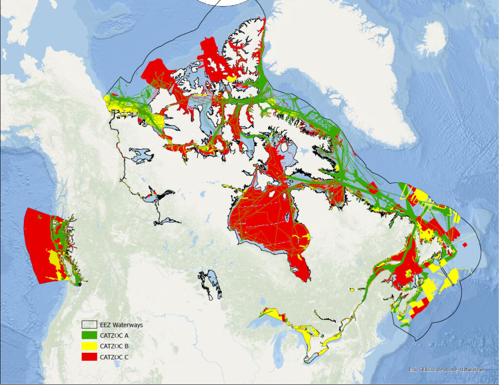
The CPPT was developed at a national scale, followed by the Audit of the Arctic Marine Navigation in the 2014 Fall Report of the Commissionaire of the Environment and Sustainable Development, to identify and prioritize Arctic regions requiring survey and charting. Since the original development of the CPPT, many improvements, updates, and insights have been incorporated into the tool itself, as well as the CPPT application available to DFO staff through the Department of Fisheries and Oceans Canada (DFO) – Marine Spatial Data Infrastructure (MSDI). The application was developed on a national scale to be served to and used by all staff no matter their geomatics skill level, to help highlight gaps in data holdings, as well as plan future survey and charting needs. Figure 1 is a representation of CHS survey holdings, comprised of CATZOC A, B, C, D, and U. The CPPT only utilizes CATZOC A, and B, which the organization deems as adequately surveyed, where the rest can be highlighted as data gaps, or areas requiring supplementary survey to be used on nautical products.
In early 2019, the Geomatics and Remote Sensing Center of Expertise (RSCoE) at CHS started the process of hosting the CPPT on the MSDI. The MSDI is led by the Canadian Hydrographic Service within DFO, while the physical infrastructure is maintained by DFO Information Management & Technology Services (IM/TS) group, with data contributors across the Government of Canada. The MSDI functions like an internet search engine while concurrently managing data, and providing environments called applications. The CPPT is one of over 50 applications that are hosted on the DFO-MSDI. The MSDI program is the vehicle chosen to develop applications and tools, create, and manage metadata to ISO 19115 Metadata Standards, and standardize / harmonize data collected by DFO (Canada’s Marine Spatial Data Infrastructure, 2021).
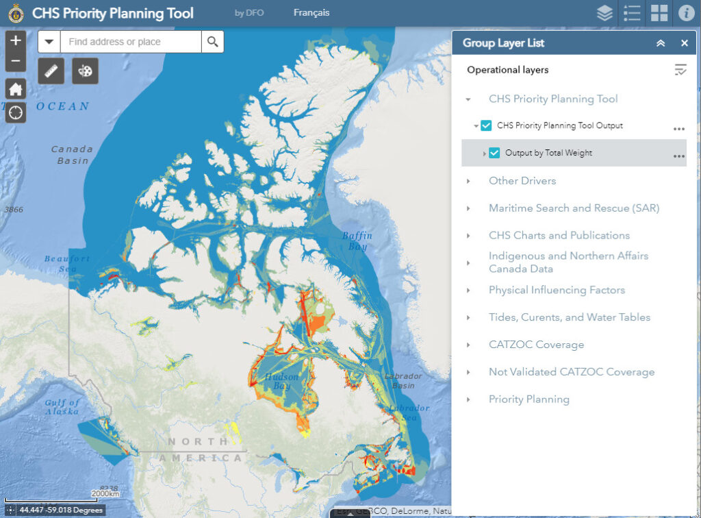
The Geomatics team decided to migrate the application to MSDI so all DFO employees would have access to the data if they had access to the intranet. The CPPT application has over forty data layers that are accessible to users and can be toggled on and off so users can view what they want. Data is grouped into common themes for ease of use, as seen in Figure 2. Some of the data layers are automatically updated daily, depending on the source of the datasets, while other layers are manually updated up to four times a year. All data on the CPPT have bilingual metadata available to users and follow the MSDI protocol of enhanced International Standards Organization (ISO) 19115 metadata standards.
3. Ongoing Improvement and Updating
Originally, the CPPT was developed using Model Builder, a visual platform for implementing repetitive processes and tasks within ArcGIS Desktop. The team recently updated the Model to be a Python Script which is much easier to manipulate, change weights when necessary, and update the input files to process the output.
The Potential Low Impact Shipping Corridors (the Corridors) are one of the main drivers in the CPPT, and originally took fruition in Northern Canada in 2014 (Chenier et al., 2017). The Corridors are an evergreen file, which CHS has nationalized to expand throughout Canada’s Exclusive Economic Zone (EEZ). The Northern Low-Impact Shipping Corridors Initiative, which is led by Transport Canada (TC), the Canadian Coast Guard (CCG) and CHS, has two main objectives; to develop a governance framework to support low-impact shipping in the North, and to identify priority areas for program and service enhancements and potential areas for vessels to avoid (Public Consultations, 2022). With the Corridors Initiative’s phase one of engagement which took place in 2018-2019, and phase two starting in Fall 2022, CHS is continually obtaining more traditional and cultural knowledge from Inuit, First Nations, Métis organizations, and other organizations currently doing similar research, that could potentially alter the routing of the Corridors. The Corridors have many factors that are incorporated in the creation, modification, and enhancement of the MSDI Corridors internal application for DFO, including local knowledge and perspectives, as well as all other data available to the team such as ship traffic pings, and climatic layers. The Corridors were developed using information that could reduce the risk to the environment, such as Marine Protected Areas (MPAs), Traditional Knowledge, and the data collected by the Environment, Society and Policy Group (ESPG) Researchers. The Corridors were developed to ensure the safety of navigation and human life.
While CHS staff are planning their survey missions, the main layer used is the tool output showing the data gaps for surveying and charting needs (Figure 2). One example is layer grouping of Indigenous and Northern Affairs Canada datasets. The dataset includes; Modern Treaties (formerly known as the post-1975 treaties) representing the signed agreements that were negotiated between Indigenous groups, the Government of Canada, and provincial and territorial governments after 1975, Historic Treaties (formerly known as the pre-1975 treaties) with the boundaries of signed treaties that were negotiated between Indigenous peoples and the Crown between 1725 and 1929, and the Indigenous agreements, which represents agreements with geographic boundaries between the Government of Canada, provinces and territories, and Indigenous organizations and communities. This information is vital for CHS staff to be aware of while mission planning, so they can understand the existing boundaries for treaties that the Crown-Indigenous Relations and Northern Affairs Canada (CIRNAC) and Indigenous Services Canada (ICS) maintain.
Another major update to the CPPT drivers is the analysis and separation of Risk of Grounding and Risk of Collision completed nationally. The Risk of Grounding assessment incorporated an in-channel analysis and on-channel margin, as per the PIANC 2014 approach (Pianc, 2022). The Risk of Collision assessment was conducted based on trip density, and vessel manoeuverability. These assessments were conducted by experts in both fields and include input from navigational experts situated throughout Canada’s major ports.
The CHS Major Projects data layer continues to evolve based on funding, ongoing survey requirements, as well as recurring surveys that must be done to ensure safety of navigation within Canadian waterways. With the recent announcement of the next phase of Oceans Protection Plan, “the Canadian Hydrographic Service will be able to address important gaps in hydrographic data by increasing surveying and charting along major marine transportation corridors in the Arctic” (News Desk- Fisheries and Oceans Canada, 2022), which will be identified and incorporated in the CPPT.
4. Conclusion
The RSCoE team continues to evolve the tool to highlight gaps that exist within Canadian waterways, and ensure the tool best represents CHS priorities, while displaying the data gaps that exist. This includes the continual maintenance of the CPPT, updating data that feeds into the tool such as the Corridors, and updating the model to show the data gaps and priorities for CHS charting and surveying needs.
Currently, one of the main drivers for the Corridors is Satellite Automatic Identification System (S-AIS) which is used to capture commercial shipping traffic. However, it does not represent small vessels, such as fishing and recreational vessels, not equipped with AIS. The team is currently investigating the analysis of small craft harbours and risk to navigation within local boating areas that are not captured in S-AIS.
In the last five years, under the Oceans Protection Plan (OPP) Initiative (Government of Canada, 2017), CHS has made instrumental progress in filling in gap, increasing survey within the Potential Low-Impact Shipping Corridors by 2% each year, and the CPPT was a key tool used in planning survey acquisition. With the announcement of the next phase of OPP (Newswire, 2022), CHS can continue to prioritize filling gaps in the Canadian Arctic with the help of the CPPT and input layers. As a next step for the CPPT, the team will look at enhancing the application to include automatic reporting by developing a dashboard with highlights from CHS. This will be used for national reporting and highlighting major strides in filling gaps in data holdings and contributing towards the hydrospatial domain.
5. References
Canada’s Marine Spatial Data Infrastructure. (2021). MSDI Marine Spatial Data Infrastructure; Presentation to the International Hydrographic Organization’s Marine Spatial Data Infrastructure Working Group March 17, 2021.
DFO (2008). The Role of the Canadian Government in the Oceans Sector.
Chénier, R., Abado, L., Sabourin, O., & Tardif, L. (2017). Northern marine transportation corridors: Creation and analysis of northern marine traffic routes in Canadian waters. Transactions in GIS, 21(6), 1085-1097.
Chénier, R., Abado, L., & Martin, H. (2018). CHS Priority Planning Tool (CPPT)—A GIS model for defining hydrographic survey and charting priorities. ISPRS International Journal of Geo-Information, 7(7), 240.
Government of Canada. (2017). Investments under the Oceans Protection Plan to protect Canada’s Arctic Coast and Water, viewed 22 February 2018, https://www.canada.ca/en/transport-canada/news/2017/08/investments_undertheoceansprotectionplantoprotectcanadasarcticco.html
Hains D., Ponce R., OEI P., Roperez J., Yang P.Y., Cove K., Cawthra H.C., Bergmann M., Maschke J., Mihailov M.E., Echeverry P., and Obura V. (2021) International Hydrographic Review Vol.26 – HYDROSPATIAL… A GLOBAL MOVEMENT! https://ihr.iho.int/articles/hydrospatial-a-global-movement/
International Hydrographic Bureau Monaco. (2014). IHO Transfer Standard for Digital Hydrographic Data Publication S-57 Supplementary Information for the Encoding of S-57 Edition 3.1 ENC Data.
News Desk – Fisheries and Oceans Canada. (2022). Announcement of funding under the Oceans Protection Plan.
Newswire. (2022). New Oceans Protection Plan Funding will bolster Canadian Coast Guard and Canadian Hydrographic Service in the Arctic.
Pianc. (2022). MarCom WG 121: Harbour Approach Channels Design Guidelines (2014).
Public Consultations. (2022). Northern Low-Impact Shipping Corridors.