

Abstract
Building on Seabed 2030 momentum, in 2020, the United States (US) debuted the National Strategy for Mapping, Exploring, and Characterizing the United States Exclusive Economic Zone (NOMEC Strategy). Both initiatives make comprehensive ocean mapping a priority this decade. The goals of Seabed 2030 and NOMEC are similar, but NOMEC goes further. Through NOMEC, the U.S coordinates and amplifies mapping efforts, but also explores and characterizes priority areas of coastal, ocean, and Great Lakes waters, advancing understanding of the marine environment. This note highlights key accomplishments of NOMEC over the last two years and presents domestic and international opportunities to progress collaboratively.
1. Background
Knowledge of the seafloor’s depth, shape, and composition has far-reaching benefits, including safer navigation, hazard mitigation for coastal resilience, preservation of marine habitats and heritage, and a deeper understanding of natural resources for sustainable blue economies. Despite widespread recognition of these benefits, The Nippon Foundation-GEBCO Seabed 2030 Project (Seabed 2030 Project) data managers currently estimate that only 23.4% of the global seafloor has been mapped (The Nippon Foundation-GEBCO, 2022).
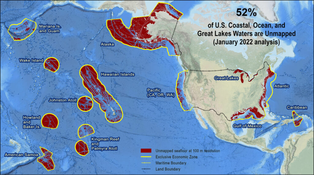
Within the US, the scale of this undertaking is massive. According to the most recent analysis, 52% of US coastal, ocean, and Great Lakes waters are currently unmapped (Interagency Working Group on Ocean and Coastal Mapping, 2022). This analysis derives from the US Bathymetry Coverage and Gap Analysis, which was previously reported in the International Hydrographic Review (Westington et al., 2019). Figure 1 shows the latest geographic distribution of these mapping data gaps.
2. NOMEC Strategy
In June 2022, NOAA formalized its commitment to mapping the ocean bottom through a signed Memorandum of Understanding with the Seabed 2030 Project. However, internal efforts to coordinate and accentuate seabed mapping in the US have been underway for some time.
In 2020, the US debuted the National Strategy for Mapping, Exploring, and Characterizing the United States Exclusive Economic Zone (or NOMEC Strategy) (Ocean Science and Technology Subcommittee, 2020). There is strong alignment between the goals of Seabed 2030 and NOMEC. However, NOMEC goes several steps further and seeks to not only map, but explore and characterize priority areas of US waters to advance our understanding of the marine environment. It also provides a structure for US federal agencies to coordinate and amplify their efforts toward these goals. Recognizing a significant difference in the effort to complete mapping in nearshore waters versus deeper waters, NOMEC applies the 2030 goal to waters deeper than 40 meters. For waters shallower than 40m, the goal is 2040.
There are five distinct goals in the NOMEC Strategy, covering interagency coordination; approaches to map, explore, and characterize the US Exclusive Economic Zone (EEZ); advancement of science and technology; and expansion of cross-sectoral partnerships (NOAA, 2021). Progress on all five goals is needed to accomplish the larger NOMEC vision.
In support of mapping all US waters by 2030 (or 2040, in the case of waters less than 40 meters), the NOMEC Implementation Plan has three primary objectives (NOMEC Council, 2021):
Objective 1: Create a Standard Ocean Mapping Protocol
The Standard Ocean Mapping Protocol (SOMP) is intended to encourage consistency in data acquisition, stewardship and data management across a subset of ocean sensing capabilities for seafloor mapping, including bathymetry (acoustic and airborne), seabed backscatter, water column backscatter, side scan sonar imagery, sub-bottom profiling, and magnetometer data readings. The overarching goal is to ensure the widest access to, use of, and integration of data, minimizing duplication of effort, and efficiently publishing, preserving, and archiving as much mapping data as possible into publicly-accessible repositories. The SOMP is under development by the US Interagency Working Group on Ocean and Coastal Mapping, consisting of representatives across the Federal government and other subject matter experts. A public review and comment period are anticipated around December 2022 and will be announced at https://iocm.noaa.gov/.
Objective 2: Coordinate and execute regional mapping campaigns
Regional campaigns focus the efforts of US federal agencies and cross-sector partners to promote efficient, effective, and comprehensive mapping of the United States EEZ. There are four basic coordination steps associated with NOMEC regional mapping campaigns:
Step 1: Catalog & analyze existing ocean and coastal mapping data to identify gaps
Step 2: Identify priorities to inform campaign planning
Step 3: Design & execute campaigns in manageable segments over time
Step 4: Track & report progress, e.g., measurable acquisition gains through coordination, responding to priorities
Other considerations associated with campaign planning include using a diverse suite of funding mechanisms; advances in technology; and the need to coordinate with exploration and characterization activities to optimize the collection of complementary data.
Within US waters, several regional campaigns are happening now. These include the Florida Coastal Mapping Program; Expanding Pacific Research and Exploration of Submerged Systems (EXPRESS) on the West Coast; Atlantic Seafloor Partnership for Integrated Research and Exploration (ASPIRE) in the Atlantic Ocean; and Lakebed 2030 covering the Great Lakes. Just last year, Seascape Alaska was formed to support not only NOMEC, but also the Alaska Coastal Mapping Strategy, which is a separate, but complementary, mandate focused on Alaska. These regional campaigns have focused resources and attention to produce progress, including:
- After conducting its own spatial priorities study and approaches documentation, the Florida Coastal Mapping Program was recently awarded mapping funds to support its goals. The Florida Coastal Mapping Program, which is a consortium of State, Federal and academic partners coordinating the collection and dissemination of consistent, high-resolution seafloor data for Florida’s coastal zone, undertook a comprehensive data inventory, conducted a gap analysis, and engaged stakeholders to develop a statewide mapping prioritization. The activities led to the 2021 legislation to award the Florida Department of Environmental Protection $100M for the Florida Seafloor Mapping Initiative, which is currently soliciting contracts from mapping vendors (Hapke, et al., 2022).
- The EXPRESS campaign, covering the US west coast, continues to leverage key Federal contributions from NOAA, Bureau of Ocean Energy Management (BOEM), and the US Geological Survey (USGS) to map the Cascadia margin and Escanaba Trough. The latter area, located 200 miles off the coast of northern California and known to contain critical minerals, has the team working with the National Science Foundation’s academic research fleet and uncrewed systems to explore the region. In addition, to provide a foundation of publicly accessible data and information products to spur further ocean exploration, research, and management, the campaign has created a public-facing data viewer at https://geonarrative.usgs.gov/expressdataview/.
- In support of the international ASPIRE campaign, along the US Atlantic coast, the Blake Plateau was mapped through collaborations with NOAA and BOEM, and NOAA continued an ongoing mapping campaign in the Caribbean filling in 17,050 square nautical miles (sqnm) of mapping gaps around Puerto Rico in 2022.
- To advance the Lakebed 2030 campaign, the Great Lakes Observing System (GLOS), a NOAA IOOS Regional Association, published a cost and approaches document (Great Lakes Observing System, 2021). Additionally, a regional spatial priorities study of the Great Lakes was concluded in 2021 and a technical memorandum is forthcoming (Gouws et al., 2022). Over the last two years, this campaign has advanced crowdsourced bathymetry (CSB) technology and application development through a series of mini-grants to innovate and stimulate this type of data collection in the Great Lakes. Through GLOS, a cloud-based, semi-automated data processing pipeline has been created to receive, process, and deliver CSB data to the International Hydrographic Organization (IHO) Data Centre for Digital Bathymetry (DCDB) as an IHO CSB Working Group Trusted Node. Lastly, the region has served as a proving ground for advanced technologies, including the operation of an iXblue DriX uncrewed surface vessel from the NOAA Ship Thomas Jefferson in Lake Erie in 2022 and sea trials of XOCEAN technology in Lake Superior by the Canadian Hydrographic Service. A story map of Great Lakes survey plans, updated weekly with the progress of the NOAA Ship Thomas Jefferson can be seen at https://storymaps.arcgis.com/stories/af8fdd814e7840789548c268c769dc11. Recognizing the potential for progress in this region through transnational collaboration, the US-Canada Hydrographic Commission discussed coordinating national efforts in the Great Lakes at its 2022 meeting.
- The Seascape Alaska campaign just formed in 2021, and in the last year, the campaign has published a story map at https://storymaps.arcgis.com/stories/094abb14281e4b2489146a3f3e030961. It also convened its first ocean mapping summit in December 2021 (Westington and Palmer, 2022). Building from an Alaska coastal and ocean mapping spatial priorities study that concluded in April 2022, the group is now partnering with the Alaska coastal mapping initiative to develop a common operating picture through dashboards and similar web applications, e.g., https://www.akmappingpriorities.com and https://www.akmappingpartnerfinder.com. Further, both groups are working toward a multiyear, coastal and ocean mapping plan of action.
- Lastly, in the central Pacific, the Exploration Vessel Nautilus, sponsored by NOAA (through Ocean Exploration Cooperative Institute), the National Geographic Society, and private donors, continues to explore uncharted areas near the Hawaiian Islands, in the Pacific Remote Islands Marine National Monument, and in Papahānaumokuākea Marine National Monument, testing new multi-platform and multi-sensor modes of operations.
Objective 3: Make data usable and available
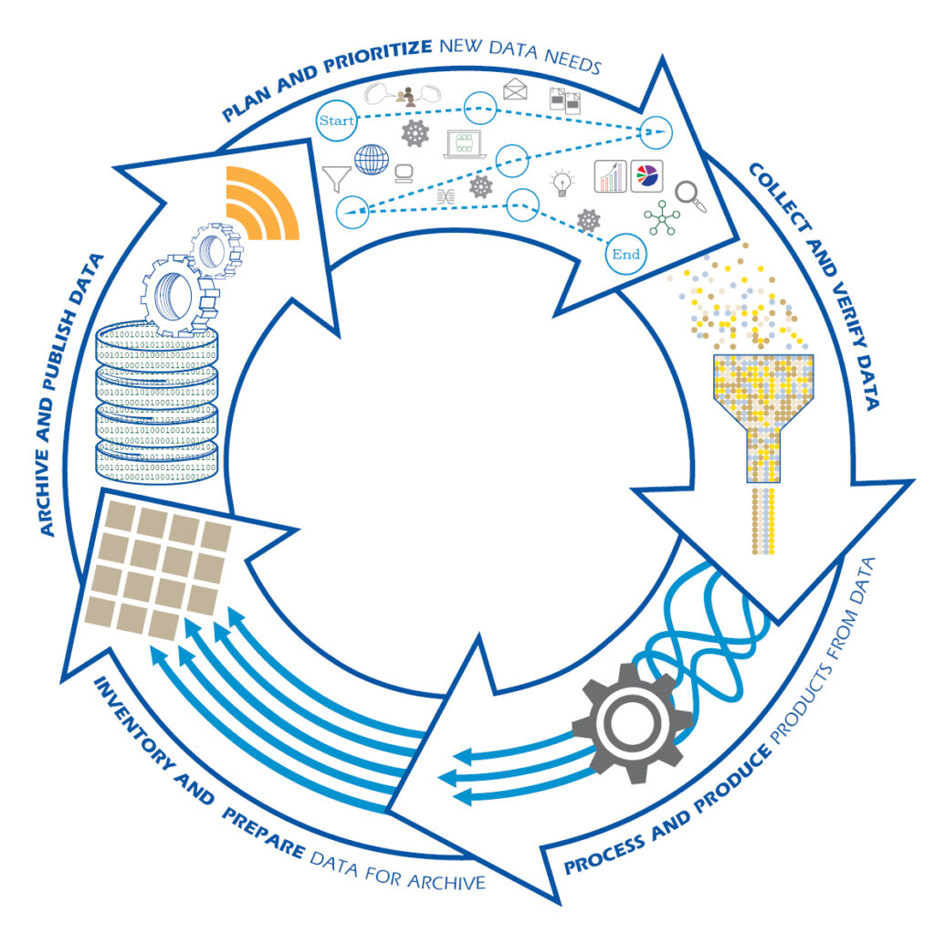
Coordinated mapping in support of NOMEC requires that data move through different stages of a lifecycle in a timely manner. As shown in Figure 2, this includes the following stages: (1) plan and prioritize new data needs; (2) collect and verify data; (3) process and produce curated, attributed products from the data; (4) inventory and prepare data for archive; and (5) archive and publish data. This objective echoes the steps needed for regional mapping campaigns and asks that all mapping data be shared with central repositories, specifically the IHO DCDB, hosted by NOAA’s National Centers for Environmental Information.
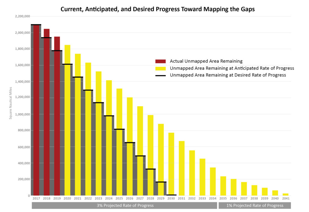
The NOMEC implementation plan states that the US needs to acquire approximately 150,000 sqnm of new bathymetry annually in order to reach NOMEC goals. This number is about three times larger than the new bathymetry data footprints going through the DCDB annually. Figure 3 shows the current, anticipated, and desired progress toward mapping the gaps in US waters based on the Bathymetry Gap Analysis results spanning 2017-2019. Looking ahead to 2022, the trend showing that we are behind in reaching our goals remains. For the last 3 years, we have progressed about 1% each year toward our goal.
In order to address the shortfalls, the US government, through NOAA, has created data sharing agreements with non-profit research institutions and private mapping companies to expand data availability for public use. For example, in 2021, NOAA announced a Memorandum of Agreement with Ørsted Wind Power North America LLC, an offshore wind development company, to share physical and biological data in Ørsted-leased waters subject to US jurisdiction. Companies, such as Fugro, have also committed to conducting opportunistic surveys while on transit and providing that mapping data to the IHO DCDB to support both national and international mapping initiatives.
3. NOMEC Partnerships
Leveraging the ongoing success of several domestic interagency partnerships, such as those listed above, the NOMEC Council chairs have reached out to their colleagues at other ocean-related agencies to better determine how the collaborative nature of NOMEC could achieve more federal goals. New technology development, multi-user datasets, polar expeditions, and nascent public-private partnerships have so far been identified as areas worthy of further exploitation by NOMEC.
Internationally, IHO partners have opportunities today to coordinate on best practices for ocean mapping, exploration, and characterization while taking advantage of advances made by the US on technology development and test beds. Ultimately, as the US continues to systematically catalog its own EEZ, other nations, especially maritime countries with fewer ocean-going assets, could develop international agreements with the US to determine how best to have their own EEZ surveyed.
4. Conclusion
As we continue on this journey, we hope that by sharing our experiences with the NOMEC strategy, we will inspire other coastal States to develop similar initiatives in support of the Seabed 2030 Project and the global need to advance our understanding of the marine environment. As new leaders of this NOMEC initiative, we have learned the value of periodically refreshing and expanding our interagency cooperation in support of NOMEC. To accelerate progress toward the NOMEC goals, we need to ensure that the NOMEC leadership and the campaigns are relevant and responsive to agency requirements, and the relationships are in place to draw on the full range of resources available.
5. References
Kearns, T., Brinks, L., Arbit, J., & Fitch, D. (2021). Cost and Approaches for Mapping the Great Lakes, Great Lakes Observing System, Lakebed 2030, viewed 2 August 2022, https://glos.org/wp-content/uploads/2021/12/Costs-and-Approaches-for-Mapping-the-Great-Lakes.pdf.
Gouws, K., Esselman, P., Brinks, L., Kearns, T., Zhang, X., Chappell, A., Krumwiede, B., Buja, K., Westington, M., & Yung, C. (2022). Great Lakes Spatial Priorities Study. NOAA Technical Memorandum NOS CS. In-work/Unpublished
Hapke, C., Baumstark, R., Druyor, R., Fredericks, X., Kramer, P., Jackson, K., McEachon, L. (2022). “Establishing seafloor mapping priorities for coastal states”, Ocean & Coastal Management, Volume 216, https://doi.org/10.1016/j.ocecoaman.2021.105942.
Interagency Working Group on Ocean and Coastal Mapping (2022). Progress Report: Unmapped U.S. Waters, viewed 2 August 2022, https://iocm.noaa.gov/documents/mapping-progress-report2022.pdf.
The Nippon Foundation-GEBCO (2022). Mapping Progress, Seabed 2030 Project, viewed 2 August 2022, https://seabed2030.org/mapping-progress.
NOAA (2021). What is the National Strategy for Mapping, Exploring, and Characterizing the United States Exclusive Economic Zone (NOMEC Strategy), National Oceanic and Atmospheric Administration (NOAA), viewed 2 August 2022, https://www.noaa.gov/sites/default/files/2021-12/NOMEC%20Factsheet.pdf.
NOMEC Council (2021). Implementation Plan for the National Strategy for Ocean Mapping, Exploring, and Characterizing the United States Exclusive Economic Zone, Ocean Science and Technology Subcommittee and Ocean Policy Committee, viewed 2 August 2022, https://iocm.noaa.gov/about/documents/strategic-plans/210107-FINALNOMECImplementationPlan-Clean.pdf.
Ocean Science and Technology Subcommittee (2020). National Strategy for Ocean Mapping, Exploring, and Characterizing the United States Exclusive Economic Zone, Ocean Policy Committee, viewed 2 August 2022, https://iocm.noaa.gov/about/documents/strategic-plans/20200611-FINAL-STRATEGY-NOMEC-Sec.-2.pdf.
Westington, M., Palmer, H. (2022). 2021 Alaska Coastal and Ocean Mapping Summit Report, U.S. Department of Commerce, NOAA, https://doi.org/10.25923/yf0p-6136.
Westington, M., Varner, J., Johnson, P., Sutherland, M., Armstrong, A., & Jencks, J. (2019). “Assessing Gaps via Bathymetric Sounding Density”, The International Hydrographic Review, 20. Retrieved from https://journals.lib.unb.ca/index.php/ihr/article/view/28876