


Abstract
1. INTRODUCTION
The transformation of our societies into digital economies requires that human knowledge and practices be translated into computer-usable formats. These conversions include the concepts and practices of public international law. The United Nations Convention on the Law of the Sea (1982) is a multilateral international treaty that lays the modern foundation for the law of the sea and establishes the international legal framework for many activities in the marine environment. Most elements of the Convention are deployed through zones that serve to locate and define the rights and obligations of States and individuals (Figure 1).
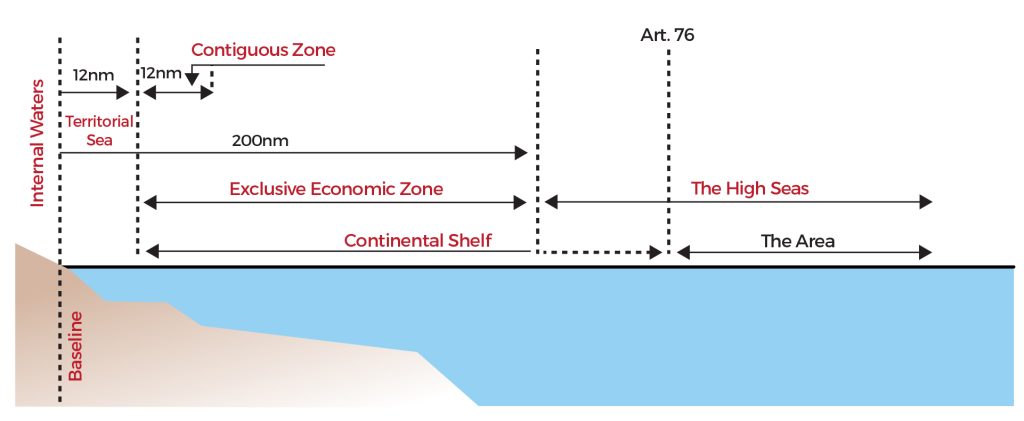
Since the entry into force of the Convention in 1994, implementing coastal States have the responsibility of making public, in the form of charts or lists of geographical coordinates, the position of:
- Baselines, outer limits and boundaries used to define their territorial sea (article 16.2);
- Archipelagic baselines used to define their archipelagic waters (article 47.9);
- Outer limits and boundaries used to define their exclusive economic zone (article 75.2); and
- Outer limits and boundaries used to define their continental shelf (articles 76.9 and 84.2).
Under the terms of the Convention, a copy of these charts or lists of coordinates shall be deposited with the Secretary-General of the United Nations.
In the years following the entry into force of the Convention, the General Assembly of the United Nations instructed the Secretary-General to establish and maintain the facilities required by the Convention. This included establishing a system for the registration and publicity of charts and lists of geographical coordinates defining the maritime zones of coastal States (United Nations, 1994, section 15f; United Nations, 1998, section 11 c).
In 2005, the United Nations General Assembly requested the Secretary-General to improve the Geographic Information System (GIS) which supported the system for recording and publicizing charts and lists of coordinates (United Nations, 2005, section 6; United Nations, 2017, section 7). To ensure the compatibility of the GIS with, among others, electronic nautical charts developed according to the guidelines and standards of the International Hydrographic Organization (IHO), the General Assembly requested the Secretary-General to implement international technical standards for data deposited by coastal States. To this end, the Division for Ocean Affairs and the Law of the Sea of the United Nations Secretariat (UN DOALOS) approached IHO in 2007 to identify technical standards for the collection, storage and dissemination of charts and lists of geographical coordinates defining maritime zones.
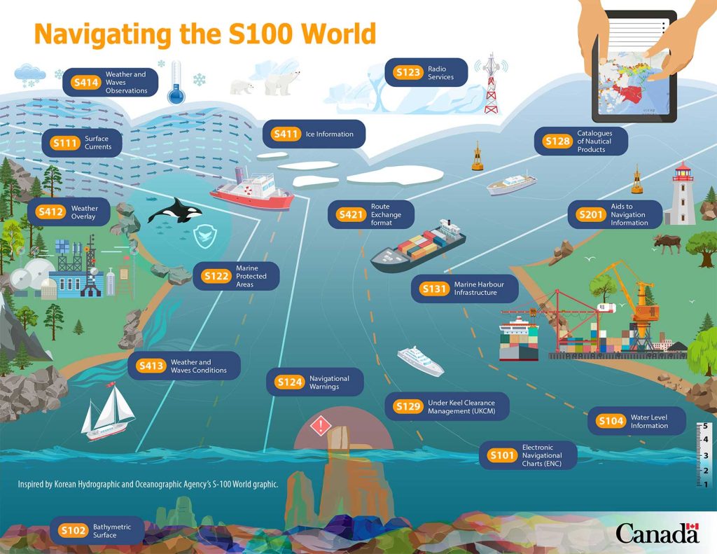
With its IHO S-57 standard (IHO, 2000), the IHO defined a technical standard for the transfer of digital hydrographic data, which allowed the representation of some of the maritime zones defined by the Convention. However, as a standard designed primarily to serve the needs of vessel navigation under the International Convention for the Safety of Life at Sea (SOLAS) (1974), the capacity of IHO S-57 to model complex legal situations was limited. In addition, the IHO was transitioning to a new standards framework based on the geospatial standards of the International Organization for Standardization Technical Committee 211 (ISO/TC211 Geographic Information/Geomatics). With the cooperation of ISO/TC211, the IHO developed, published and adopted the S–100 Universal Hydrographic Data Model in 2010 (IHO, 2010). The model defines a framework for the development of the next generation of marine digital products and services (navigational and non-navigational). A series of IHO S-100 products conforming to the framework have been subsequently developed to support e-navigation, dynamic and time-varying information, imagery and gridded bathymetry, 3D data, near-real time services (Figure 2). Approved IHO S-100 product specifications elements are registered in the IHO S-100 Geospatial Information Registry – becoming available for inclusion in other IHO S-100 product specifications. The IHO S-100 framework also offers a modular concept where the IHO S-100 core specifications are shared by all the IHO S-1XX family of products. For navigation users, this enables a plug and play combination of IHO S-100 products overlaying, interleaving with or replacing interoperably the data of the IHO S-101 Electronic Navigational Chart (ENC) product (Ward and Greenslade, 2011).
In 2009, UN DOALOS presented the first draft of what would become S-121 to the IHO Transfer Standard Maintenance and Application Development Working Group 25. Geoscience Australia, in collaboration with the Canadian Hydrographic Service and CARIS, proposed in 2013 (McGregor et al., 2012) a slightly modified version to Hydrographic Services and Standards Committee 5, which assigned it the identifier ‘S-121’ and title ‘Maritime Limits and Boundaries’. It is in this context that the IHO authorized in 2016 the creation of a project team for the development of an international standard for maritime limits and boundaries.
The project team’s general objective was to develop a standard that could support the deposit of coastal States’ limits and boundaries with the Secretary-General of the United Nations. This involves the management, description and exchange of these data as described in the United Nations Convention on the Law of the Sea. Eventually, IHO S-121 needed to be able to support the deposit of charts (in paper or digital format) and human-readable coordinates. It was also expected that the standard would indirectly support the representation of limits and boundaries on IHO S-57 (IHO, 2000) or IHO S-101 (IHO, 2018b) Electronic Navigational Charts.
The specific objectives of the project team were to (1) define a data model for the limits and boundaries described in the United Nations Convention on the Law of the Sea and (2) produce a product specification conformant with the IHO S-100 framework. The team was also asked to (3) make recommendations, if necessary, to modify IHO S-100 to facilitate the deposit of limits and boundaries by coastal States to the Secretary-General of the United Nations (IHO, 2021).
This article presents the development of the IHO S-121 standard. Section 2 Materials and methods discusses the methodology, design processes and verification processes used to define the data model and the product specifications. Section 3 Results presents the data model and some other important elements of the IHO S-121 product specification. The project team’s recommendations made to the IHO are also presented in this section. Concluding remarks are presented in Section 4.
2. MATERIALS AND METHODS
Activities of the project team officially started at the United Nations headquarters in New York in December 2016 under the chairship of Australia and Canada. They were conducted under the guidance of the IHO’s Hydrographic Services and Standards Committee (HSSC) and followed the IHO principles and procedures for making changes to IHO technical standards and specifications (IHO, 2020a).
As a first step, the project team was required to define a data model. Concretely, the project team (1) identified the elements referring to limits and boundaries in the Convention, (2) defined the entity types, their attributes and relationships that allow them to be described adequately, and (3) represented them formally in an application schema. In relation to IHO S-100 Part 1 (IHO, 2018a), ISO 19101-1 (ISO, 2014) and ISO 19103 (ISO, 2015a), the modeling was object-oriented and used the Unified Modeling Language (UML). The data model also complied with the General Feature Model (GFM) defined in ISO 19109 (ISO, 2015b) and the derivative model specified in IHO S-100 Part 3 (IHO, 2018a). The defined entities were harmonized with those used for other product specifications in the IHO S-100 series in order to store them in the IHO’s geospatial registry.
As a second step, the project team was required to produce a product specification for the data model. IHO S-100 product specifications are technical descriptions that define the S-100 series of geospatial data products. Documents were formatted according to the guidelines in Part 11 of the IHO S-100 Standard (IHO, 2018a), which is itself based on the IHO S-97 (IHO, 2020b) and ISO 19131 (ISO, 2007) standards.
The process was undertaken in cooperation with representatives from: UN DOALOS, United Nations Committee of Experts on Global Geospatial Information Management (UN-GGIM), IHO, Australia, Belgium, Canada, China, Denmark, France, Japan, Netherlands, Republic of Korea, Russia, Sweden, United Kingdom, United States, and the private sector. As a result, the data model was revised in light of different national and international perspectives. The data model was also revised and operationalized by technical experts as part of a pilot project led by the Open Geospatial Consortium (OGC). These revision processes made it possible to improve the data model and to formulate recommendations.
3. RESULTS
3.1 IHO S-121 data model and product specification
The first version of IHO S-121 (IHO, 2019b) was formalized for testing on October 30, 2019 (IHO, 2019a). It is an IHO S-100 product specification compliant with IHO and ISO standards. It is intended for the encoding and exchange of digital maritime boundary information, including maritime limits, zones and boundaries as described in the United Nations Convention on the Law of the Sea.
The data model has been developed to rigorously apply the provisions of the Convention, while allowing sufficient flexibility to take into account the different ways in which States implement the Convention under their national legislation.
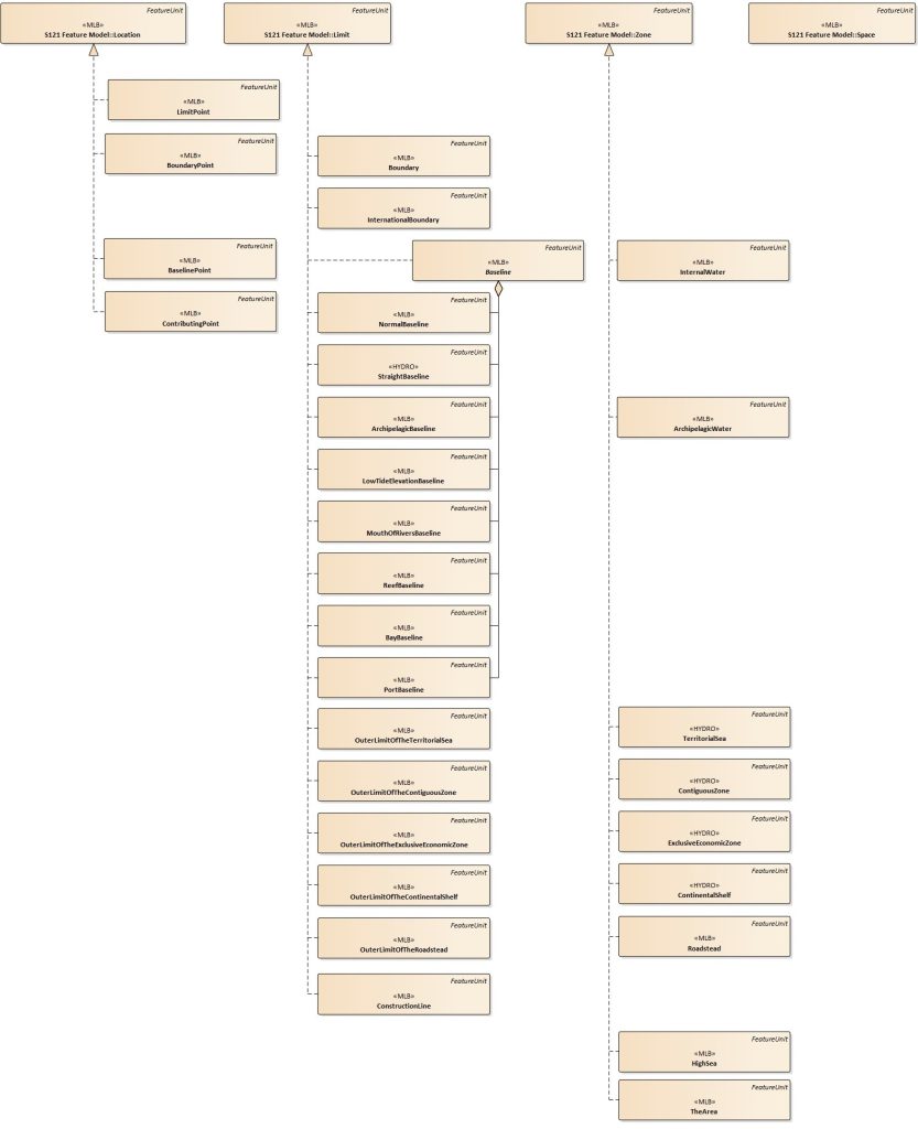
The IHO S-121 data model incorporates the geometry, entity structure and attributes of the IHO S-100 model. It also defines new features, attribute types and relationships. In particular, it defines the geographic feature types described by the Convention (Figure 3) as follows:
- Volumetric features are referred to as ‘spaces’ in the standard. They are constructed in the Convention from two-dimensional surfaces (on the surface of the Earth). For example, the territorial sea is defined as a belt of sea between the baselines and the outer limit of the
territorial sea, together with the overlying air space, and underlying seabed and subsoil (Article 2). - Surface features – called ‘zones’ – are constructed from linear features that define them. The following are considered as ‘zones’: internal waters, archipelagic waters, roadsteads, territorial sea, contiguous zone, exclusive economic zone, continental shelf, High Seas and the Area.
- Linear features – called ‘limits’ – are defined by means of point features. ‘Limits’ include baselines, construction lines, international boundaries, and the outer limits of the territorial sea, the contiguous zone, the exclusive economic zone, the continental shelf and roadsteads. Baselines include normal, straight, and archipelagic baselines, as well as low tide elevations, mouths of rivers, reefs, bays and ports.
- Point features – called ‘locations’ – can be described using geographic or cartographic coordinates. Limit, boundary, baseline and contributing points are considered as ‘locations’.
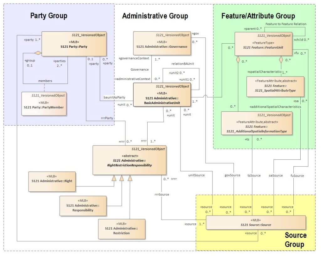
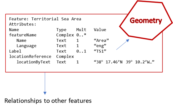
The geographic features of the Convention are related to legal information. The approach used by IHO-121 to model these relationships is the creation of several IHO S-100 information types that behave as attributes with respect to the geographic features. In this sense, four components, constituting the core of the conceptual model, may define an object (Figure 4):
- A mandatory geospatial component that defines the type of feature and its geographic location;
- An administrative/legal component that designates the rights and obligations associated with the geographic feature and provides a description of them;
- A ‘party’ component that defines the actors associated with the rights and obligations and their roles;
- A ‘source’ component that provides the legal references (treaties, laws, decrees, official charts, etc.) for each of the other components.
To these components must be added the relationships (linking geospatial, administrative/legal information, parties and sources to each other) and temporal attributes (allowing, through versioning capabilities, a feature to trace its evolution over time). These components are concepts
already used for land administration and are derived from the ISO 19152 data model (ISO, 2012).
The emergence of new information technologies has enabled the development of multi-functional digital cadastres and the integration of land administration activities (Dale & McLaughlin, 1999; UNECE, 1996). Modern cadastres now integrate objects created by international and public law (FIG, 1998, 2014) and are conceived, not only as systems for recording private rights, but as land information systems supporting management and decision making (Williamson et al., 2010). It is within this process of redefining the role of cadastres in digital environments and the development of the land administration paradigm (Williamson et al., 2010) that the concept of a marine cadastre has emerged (FIG, 2003; Nichols et al., 2006). The marine cadastre can be defined as a management tool to identify and effectively administer formally or informally defined boundaries in the marine environment, and the associated rights, restrictions, and responsibilities (FIG, 2006). IHO S-121 thus extends land administration concepts to maritime limits and boundaries.
The IHO S-121 product specification provides information on reference systems and metadata, as well as multiple aspects of the data itself (i.e. product identification, content and structure, quality, capture, product format (encoding), and product delivery).
Under the standard each individual UNCLOS entity is defined and implemented using the IHO S-100 General Feature Model, which assigns a number of spatial and semantic attributes (both simple and complex) and relationships between defined features, resident in the IHO Geospatial Information Registry (Figure 5). The features have attributes representing simple management elements, multilingual names, persistent unique identifiers and the facility to include textual descriptions of positional information alongside geospatial locations encoded in each feature. Non-spatial IHO S-100 information types are also capable of being associated with geospatial features to represent ISO 19152 structures for management of rights, restrictions and responsibilities in respect of the geospatial features. Such information types can be shared between multiple geospatial features, improving data management capabilities.
The annexes to the standard include validation tests and the application schema description. The annexed Data Classification and Encoding Guide describes all feature objects and attributes defined for maritime limits and boundaries. This includes a complete feature catalogue that provides the definition of each feature, attribute, code list and listed value. An encoding guide describes the approach to encoding IHO S-121 data. This document includes a text format that can be easily read by humans. A document for class derivation details the existing relationships between the IHO S-121 data model and classes derived from IHO S-100, ISO 19152 and other ISO standards.
3.2 Recommendations
As the IHO S-121 standard reached a stage where operationalization tests could be conducted, another standards development organization, the OGC, was approached by a group of countries with common interests. Natural Resources Canada, the Canadian Hydrographic Service, Geoscience Australia and the United Kingdom Hydrographic Office sponsored an OGC-led pilot project to operationalize the IHO S-121 standard (OGC, 2021). Through its Innovation Program and in accordance with a memorandum of understanding with the IHO, the OGC was able to draw on its expert marine members to advance an IHO standard. The results of the OGC pilot project identified ways to improve the IHO S-100 standard. Some of the components required to complete the IHO S-121 standard were also completed during the OGC pilot. An essential requirement of the OGC pilot was the support of multilingual data through the IHO S-121 standard. This requirement enabled the support of legislative information in multiple languages.
The OGC pilot project provided a first level of thorough functional testing. Testing was based on an implementation using interoperable technologies and representative data from existing data producers. A set of test datasets was defined, conforming to the IHO S-121 model and the IHO S-100 framework and used to illustrate OGC web services promulgation of data and metadata (Figure 6).
Testing showed:
- The adequacy of the IHO S-121 model and its implementation of both UNCLOS zones and ISO 19152 rights management structures. Some improvements/enhancements to the IHO S-121 model were made in respect of multilingual support.
- The applicability of Geographic Markup Language (GML) for data encoding and how IHO S-100 can be adapted for data management as well as representation of product specific content. The mapping of the S-100 General Feature Model to the GML encoding has been reused in the recent OGC FMSDI pilot to develop a prototype GeoJSON encoding for IHO S-100 content as well.
- Interoperability between non-maritime and non-IHO technologies, such as OGC web service APIs and structured query/retrieval tools. Such interoperability showed strengths (good support for feature base data) and some challenges (feature relationships and complex attribution).
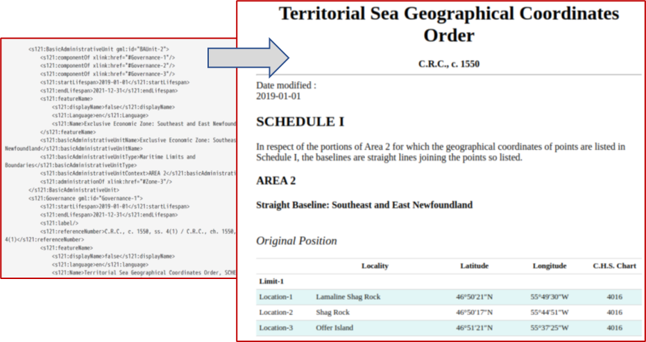
- The ability to recreate textual publications from feature based geospatial data, matching existing supporting documentation issued by producer agencies for defined zones within the scope of the standard. This enables a single source of geospatial data to be used for discoverability, content distribution and standardised documentation.
The practical implementation of the standard required changes to facilitate the implementation and adaptation of existing software tools and frameworks. Use of the GML encoding is complex and support for IHO S-100’s General Feature Model (GFM) in GML is still at an early stage in community toolsets. IHO S-100 editing systems, at the time, were still at an early stage of development and the coupling between the data model and encoding representation still fairly loose. This mapping of data models to encoding specifics is now more formally specified in IHO S-100.
The synergy between the participants allowed for exploratory integration between various technologies and confirmation of the interoperability of the standard while preserving data integrity through iterative import-publish-view-query-export cycles. Use of international standards frameworks from IHO and OGC presents a common language for technical and non-technical dialogue between stakeholders from diverse backgrounds. An important element, then, of such projects is how stakeholder inputs guide technical innovation. For example, many of the subsequent improvements to IHO S-100 Part 10b, the implementation of GML, were defined during the project and are reflected in the soon-to-be published edition 5.0.0 of IHO S-100.
The OGC Pilot produced a number of recommendations to both IHO and OGC. Proposals for improvements, such as the aforementioned rewrite of S-100 Part 10b have been taken forward into the upcoming edition 5.0.0 and the drafted GML encoding is formally described in the working draft of the updated IHO S-121 standard. The recommendations were intended to strengthen the link between GML formats and the underlying catalogues used to specify data structure in the standard. A thorough modernization and revision of the GML Profile in S-100 Part 10b has been carried through as a direct result of the findings of the pilot. The pilot proposed a methodology for integration of IHO S-121 data with other domains and the requirements for such inclusion specific to the domain. Although at a prototype stage, such integration has great potential for the reuse of S-121 data in different scenarios as S-100 is adapted for use in domains other than navigation. Further recommendations to IHO standards groups include the shaping of detailed encoding guidance (particularly in respect of ISO 19152), improved capability for textual representations of positional information from legal sources and validation of S-121 data to assure conformance with both the standard and the S-121 feature catalogue. Recommendations to both groups on how to approach cross-community and interdisciplinary teams have been made to strengthen work carried out under the formal memorandum of understanding which exists between the two organizations. For example, the IHO Marine Spatial Data Infrastructure Working Group (IHO MSDIWG) now has a specific interest and agenda topics for IHO S-100 integration and use of the IHO S-100 framework directly to better support broader implementation of the framework outside the navigational domain. The OGC Marine Domain Working Group (OGC Marine DWG) has used the experience of the project to refine scope for future projects and is using the project approach in the current Federated Marine Spatial Data Infrastructure Pilot Project in the related domain of marine protected areas.
4. CONCLUSION
The project team defined a data model for the limits and boundaries described in the United Nations Convention on the Law of the Sea, produced a product specification conformant with IHO S-100 framework and made recommendations to IHO. The first version of IHO S-121 (IHO, 2019b) was formalized for testing on October 30, 2019 (IHO, 2019a).
The development of IHO S-121 represents a model of collaboration between the three main geospatial standards development organizations (ISO, IHO, OGC). The standard provides coastal States with a standards-based tool to communicate the official data of their maritime limits and boundaries. It constitutes a practical means for coastal States to fulfil their international responsibilities for publication and deposit with the Secretary-General of the United Nations. It also provides a flexible and extensible framework capable of meeting other delineation needs.
The elements of ISO 19152 provide a basis for extending IHO S-121 to the management of other marine legal spaces. In principle, the use of a model already used for land administration enables interoperability of systems and seamless administration of the territory in the coastal zone. All this is in line with the vision of the IHO S-100 Universal Hydrographic Data Model, which sought to expand its user base.
The IHO S-121 standard allows a digital realization of an important international agreement signed by 168 parties (UN DOALOS, 2021). Following the emerging concept of georegulation, it links the legal elements to their spatio-temporal frame and thus puts forward the capabilities offered by geomatics to support sustainable management of ocean space.
5. REMARKS
Material from S-121 Ed 1.0.0 is reproduced with the permission of the International Hydrographic Organization (IHO) Secretariat (Permission No 10/2021) acting for the International Hydrographic Organization (IHO), which does not accept responsibility for the correctness of the material as reproduced: in case of doubt, the IHO’s authentic text shall prevail. The incorporation of material sourced from IHO shall not be construed as constituting an endorsement by IHO of this product.
To be noted: S-121 Ed 1.0.0 is released for implementation and testing purpose only.
NRCan contribution number: 20210422
6. REFERENCES
Dale, P. F. and McLaughlin, J. D. (1999). Land administration. New York: Oxford University Press.
Fisheries and Oceans Canada. (2019). Sovereignty and UNCLOS. Retrieved from https://www.dfo-mpo.gc.ca/science/hydrography-hydrographie/UNCLOS/index-eng.html
Fisheries and Oceans Canada. (2021). Infographic: Navigating the S-100 World. Retrieved from https://www.dfo-mpo.gc.ca/about-notre-sujet/publications/infographics-infographies/chs-s100-shc-eng.html
International Convention for the Safety of Life at Sea (SOLAS). (1974).
International Federation of Surveyors (FIG). (1998). Cadastre 2014: A vision for a future cadastral system (J. Kaufmann & D. Steudler, Eds.).
International Federation of Surveyors (FIG). (2003). Report on the Outcomes of the UNB-FIG Meeting on Marine Cadastre Issues (M. D. Sutherland, Ed.). Fredericton.
International Federation of Surveyors (FIG). (2006). Administering Marine Spaces : International Issues (A. Greenland & P. van der Molen, Eds.). Copenhagen, Denmark.
International Federation of Surveyors (FIG). (2014). CADASTRE 2014 and Beyond. Copenhagen, Denmark.
International Hydrographic Organization (IHO). (2000). S-57 – IHO Transfer Standard for Digital Hydrographic Data (Ed. 3.1). Monaco: International Hydrographic Bureau.
International Hydrographic Organization (IHO). (2010). S-100 – Universal Hydrographic Data Model (Ed. 1.0.0). Monaco: International Hydrographic Bureau.
International Hydrographic Organization (IHO). (2018a). S-100 – Universal Hydrographic Data Model (Ed. 4.0.0). Monaco: International Hydrographic Bureau.
International Hydrographic Organization (IHO). (2018b). S-101 – Electronic Navigational Chart Product Specification (Ed. 1.0.0). Monaco: International Hydrographic Organization (IHO).
International Hydrographic Organization (IHO). (2019a). HSSC Letter 04/2019.
International Hydrographic Organization (IHO). (2019b). S-121 – Maritime Limits and Boundaries Product Specification (Ed. 1.0.0). Monaco: International Hydrographic Organization (IHO).
International Hydrographic Organization (IHO). (2020a). M-3 Resolutions of the International Hydrographic Organization (2nd ed.). Monaco: International Hydrographic Organization (IHO).
International Hydrographic Organization (IHO). (2020b). S-97 – IHO Guidelines for Creating S-100 Product Specifications (Ed. 1.1.0). Monaco: International Hydrographic Organization (IHO).
International Hydrographic Organization (IHO). (2021). S-121 Project Team – List of documents. Retrieved from https://iho.int/mtg_docs/com_wg/S-100WG/S-121PT/S-121PT.htm
International Organization for Standardization (ISO). (2007). ISO 19131:2007 – Geographic information — Data product specifications.
International Organization for Standardization (ISO). (2012). ISO 19152:2012 – Geographic information — Land Administration Domain Model (LADM).
International Organization for Standardization (ISO). (2014). ISO 19101-1:2014 – Geographic information – Reference model – Part 1: Fundamentals.
International Organization for Standardization (ISO). (2015a). ISO 19103:2015 – Geographic information — Conceptual schema language.
International Organization for Standardization (ISO). (2015b). ISO 19109:2015 – Geographic information — Rules for application schema.
McGregor, M., Büchsenschütz-Nothdurft, O.and Lévesque, S. (2012). S-10X, The Digital Maritime Boundary Product Specification under S-100. 7th ABLOS Conference. Monaco.
Nichols, S. E., Ng’ang’a, S. M., Sutherland, M. D., & Cockburn, S. (2006). Marine Cadastre Concept. In B. Calderbank, A. M. MacLeod, T. L. McDorman, & D. H. Gray (Eds.), Canada’s Offshore: Jurisdiction, Rights, and Management (3rd Ed., pp. 211–235). Trafford Publishing.
Open Geospatial Consortium (OGC). (2021). OGC Maritime Limits and Boundaries Pilot: Engineering Report. Retrieved from http://docs.opengeospatial.org/per/20-013r4.html
United Nations. Resolution adopted be the General Assembly. A/RES/49/28 (1994).
United Nations. Resolution adopted be the General Assembly. A/RES/52/26 (1998).
United Nations. Resolution adopted by the General Assembly on 17 November 2004. A/RES/59/24 (2005).
United Nations. Resolution adopted by the General Assembly on 23 December 2016. A/RES/71/257 (2017).
United Nations – Division for Ocean Affairs and the Law of the Sea (UN DOALOS) (2021). Chronological lists of ratifications of, accessions and successions to the Convention and the related Agreements. Retrieved from: https://www.un.org/Depts/los/reference_files/chronological_lists_of_ratifications.htm
United Nations Convention on the Law of the Sea. (1982). Montego Bay.
United Nations Economic Commission for Europe (UNECE). (1996). Land Administration Guidelines: With Special Reference to Countries in Transition. New York and Geneva: United Nations.
Ward, R. and Greenslade, B. (2011). IHO S-100, The Universal Hydrographic Data Model. Monaco: International Hydrographic Organization (IHO). Retrieved from https://legacy.iho.int/mtg_docs/com_wg/TSMAD/TSMAD_Misc/S-100InfoPaper_FinalJan2011.pdf
Williamson, I. P., Enemark, S., Wallace, J. and Rajabifard, A. (2010). Land administration for sustainable development. Redlands, California: ESRI Press.
7. AUTHORS BIOGRAPHIES
Jean-François Beaupré works as a Senior Surveyor for Natural Resources Canada, Surveyor General, Cadastral Survey Information. He participated in the IHO S-121 project team’s development activities and the Open Geospatial Consortium (OGC) pilot project on Maritime Limits and Boundaries. In the recent years, he also acted as a technical expert for different projects for the Standard Council of Canada (SCC), International Standard Organization (ISO), International Federation of Surveyor (FIG), and United Nations Committee of Experts on Global Geospatial Information Management (UN-GGIM). He holds a B.Sc. in Geomatics from Université Laval, Canada and a M.Sc. in Land administration from ITC, Netherlands. Email: jean-francois.beaupre@nrcan-rncan.gc.ca
Serge Lévesque joined the Canadian Hydrographic Service in 2011 as part of the team responsible for Canada’s Maritime Limits and Boundaries (MLB) and nautical geodesy. He now develops and implements standards supporting Canada’s Marine Spatial Data Infrastructure (MSDI). He participated in the IHO S-121 project team’s development activities and the OGC pilot project on MLB where S-121 was further developed. He holds a B.Sc. in Geological Engineering from Laval University, Québec and a M.Sc. in Oceanography from Dalhousie University, Halifax, Nova Scotia, Canada. Serge held the CARIS LOTS (Law Of The Sea software) product manager position for five years. Email: serge.levesque@dfo-mpo.gc.ca
Ryan Ahola is an Environmental Scientist with Canada’s national mapping agency: Natural Resources Canada’s (NRCan) Canada Centre for Mapping and Earth Observation. He acts as the technical liaison between NRCan and the Open Geospatial Consortium (OGC), helping to coordinate the many activities NRCan undertakes with OGC as a Strategic Member. He also fulfills additional roles to help advance Canada’s Geospatial Data Infrastructure, from supporting Canada’s participation at the United Nations Committee of Experts on Global Geospatial Information Management to driving the use of microservices to modernize NRCan’s geospatial information technology systems. Ryan also has a background in satellite imagery analysis. Email: ryan.ahola@nrcan-rncan.gc.ca
Sébastien Durand works for Natural Resource Canada, Canada Centre for Mapping and Earth Observation, an organization supporting Canada Open directive. His contributions to the Maritime Limits and Boundaries S121 started many years ago as technical advisor in the Canadian Hydrographic Services, within Fisheries and Oceans Canada. He contributed to the IHO-S121 project team as vice-chair, integrating vision and contributions made by all members of this great team of experts. He bares the conviction that this standard enables the integration of the administration context within geomatics, which represents an opportunity to leverage space and time to enhance decision making. Email: sebastien.durand@nrcan-rncan.gc.ca
C. Douglas O’Brien, President of IDON Technologies Inc., has extensive experience with respect to Information Technology with emphasis on the handling of spatial data in a standards environment. He has served as International Convenor of ISO TC211 Geographic Information Working Group 6 on Imagery for 15 years and has been involved in all aspects of information technology standardization for over 40 years. The Canadian Government has twice honored Mr. O’Brien with the Public Service Merit Award, he was awarded the Engineering Medal of the Association of Professional Engineers of the Province of Ontario for Research and Development and was co-recipient of the Touche-Ross New Perspectives Award. Douglas O’Brien was born in Ottawa Canada and received his Bachelor’s and Master’s degrees from Carleton University in Ottawa Canada. Email: cdobrien@idontech.ca
Jonathan Pritchard has over twenty years experience in Hydrography and more than thirty years in the technology industries. He works for IIC Technologies in the United Kingdom where he is the senior technical manager. Jonathan is an active contributor and active participant in many of the leading IHO working groups developing technical standards for marine geospatial phenomena. He is a former IHO working group chair, a current co-chair of the ENC conversion subgroup and also co-chair of the OGC’s Marine Domain Working Group. Email: jonathan.pritchard@iictechnologies.com
Mark Alcock is the Principal Advisor for Georegulation and Law of the Sea at Geoscience Australia, where he leads Australia’s offshore boundary program. He has a particular interest in the digital transformation of land administration and sound management of the oceans for the public good. He has chaired the S-121 project team at the International Hydrographic organisation since its inception. He has provided assistance on management of the marine space to more than 20 countries. He has a BSc in Geology from the University of Canberra and Graduate Diploma in Legal Studies from the Australian National University. Email: mark.alcock@ga.gov.au