


Abstract
1. INTRODUCTION
Are you interested in positioning, navigation and bathymetric surveying? Do you need precise heights for your applications? Believe it or not, you rely on a whole bunch of infrastructure and services which are provided by governmental agencies and scientific institutions. Of course, each of us has heard about the Global Positioning System (GPS) and other global navigation satellite systems (GNSS) like the European GALILEO. It is implemented in our cars, vessels, smartphones etc. It provides very reliably our position and probably nobody wants to miss the large variety of apps which make use of this technique in his or her daily life. No doubt, GNSS was the game changer not only for the surveying specialists. It made positioning and navigation easy and operational and opened it for a lot of new areas of application. But, the global navigation satellite systems and corresponding augmentation systems like the national positioning services are only one side of the coin, especially in the height component.
Precise positioning, navigation and height determination require not only the use of a sophisticated measurement equipment by the user. Typical user expectations are the seamless cross-border usability, the support of GNSS-based survey technologies and the interoperability with other measurement techniques, the provision of positioning services and real-time applications as well as an easy and user-friendly support. To meet these requirements, one needs common geodetic standards, reference systems and their physical implementation – the reference frames as well as services and models in order to provide the coordinate to the user. All these components are part of the geodetic infrastructure, the background of the spatial reference.
This article focuses especially on the third dimension, the height component of the position, and the activities and infrastructure which are necessary to improve the accuracy and reliability for the GNSS based height determination in the Exclusive Economic Zone (EEZ) of the North and Baltic Sea over more than one decade. Common cross-border geodetic standards for the height component are by no means self-evident. We review the current state of height systems in Europe and motivate the reasons for this situation. GNSS height determination supposes additional information about the common conventional height reference surface, since GNSS measurements are not a one-to-one replacement of the traditional height measuring techniques. A more or less complete survey of the Earth’s gravity field in the German EEZ was necessary in order to collect the necessary data for the computation of a corresponding model.
2. GEODETIC REFERENCE SYSTEMS — THE NECESSARY MAINSTAY OF A COMMON GEODETIC INFRASTRUCTURE FOR SURVEYING AND NAVIGATION
The conventional zero level for altitude readings at land or in our nautical charts is usually the natural boundary surface between ocean and atmosphere – or simply the sea level. For example, so far depth readings in the nautical charts of the Baltic Sea were related to the mean sea level (MSL). Charts of the North Sea additionally take the lowest tidally induced water level (lowest astronomical tide, LAT) into account. More precisely, our height reference surface shall be an equipotential surface of the Earth’s gravity field in the level of the mean sea level. Each point at that surface has the same potential energy and no water is flowing at this surface. This corresponds to our natural understanding of points with the same height. This height reference surface is called geoid in the geodetic community (Torge and Müller, 2012).
In order to determine the mean sea level and to specify the zero level of their national height systems, the European countries used various tide gauges and different epochs. Even within countries, charts may be or have been related to different tide gauges, e.g., in Sweden. Due to different conventions like these, the national height systems and sea charts share no common zero level. Water readings or charted depths of different countries are not intercomparable. The national heights across borders can vary up to several decimeters due to different definitions and/or realizations of the height system (BKG, 2022). The reason for that is not just a matter of tradition, but practical. There was simply no method available in order to measure height differences over very large distances or even the ocean with sufficient accuracy. This is an important difference to horizontal coordinates, which can be determined by GNSS techniques with high accuracy since decades. But this situation is just changing and the work described in this article is one step forward to a common and reliable height reference surface for the German EEZ and the neighboring countries.
Meanwhile, some countries have changed their national conventions and use the Normaal Amsterdams Peil (NAP) which is the common zero level of the European Vertical Reference System (Ihde et al., 2007; Sacher and Liebsch 2019; BKG, 2019). A main step forward to a common chart datum for the whole Baltic Sea was initiated by Chart Datum Working Group (CDWG, http://www.bshc.pro/working-groups/cdwg/) installed by the Baltic Sea Hydrographic Commission (BSHC). In the frame of CDWG a common chart datum for the whole Baltic Sea, the Baltic Sea Chart Datum 2000 (BSCD2000), was defined (Ågren et al., 2021; Schwabe et al., 2020). It is based on NAP as well as the common European geodetic reference systems for heights (European Vertical Reference System, EVRS) and positioning (European Terrestrial Reference System 1989, ETRS89). In the German Baltic Sea areas, BSCD2000DHHN2016 was introduced as the new official chart datum on August 4th, 2021 (BSH, 2021). Since the German height system DHHN2016 already complies with the specifications of the BSCD2000, this had no practical implications for the mariners and charted depths remained unchanged.
3. GNSS-AIDED HEIGHT DETERMINATION
Since the heights obtained by GNSS are not related to our natural height reference surface, the geoid at the mean sea level, it cannot be directly used for most applications. GNSS-only heights are not related to the Earth’s gravity field and they are not able to provide information about the real slope of the terrain, respectively the water flow, which is an essential requirement for all hydrographic applications. GNSS-based heights are related to a pure geometrically defined figure of the Earth – a spheroidal surface called mean Earth ellipsoid which is rotationally symmetric and flattened at the poles by about 22 km. The real Earth, respectively the surface of the oceans, differs from this ideal figure by up to ±100 m. The physical reasons are the inhomogeneous mass distribution caused by the topography of the Earth as well as density differences in its interior. These mass irregularities are mirrored at the ocean surface and cause the “bumps and dents” compared to the idealized Earth model. At first glance, 100m do not seem that much from a glo-bal perspective. But these irregularities are also relevant at smaller scales. For example, in the German EEZ they vary approximately between 35m and 40m in the Baltic Sea and between 39m and 43m in the North Sea. This is far too much for a safe navigation and cannot be ignored. Therefore, GNSS height determination requires additional information about these irregularities in the separation between the height reference surface and the mean Earth ellipsoid. Models providing this information are usually called geoid or quasigeoid1 model. Such models are used not only for ship navigation but also in offshore engineering, e.g. construction and supply of wind farms, oil and gas platforms, pipelines etc. (Omar et al., 2020).
A model which is compatible with the official German national geodetic reference systems was published first in 2005 by the Federal Agency for Cartography and Geodesy (BKG) and the Institute of Geodesy (IfE) of the Leibniz University Hannover (LUH) (Schirmer et al., 2005; Liebsch et al., 2006). It is called German Combined Quasigeoid (GCG). Back then, it was restricted to the mainland. Extensions for the Baltic and North Sea were published in 2009 (Liebsch et al., 2009). Updates in 2011 and 2016 brought a higher accuracy of the model and adaptions to the new national geodetic reference frame (Schwabe et al., 2016; Schirmer et al., 2018). Meanwhile, the German Combined Quasigeoid model is an integral component of the geodetic infrastructure in Germany and is used in practically every GNSS-based height determination. It guarantees the full compatibility with the national geodetic reference frames which are immanently used with the German satellite positioning service SAPOS. Without models like GCG, GNSS-based height determination would not be interoperable with other measurement techniques for height determination like spirit leveling.
GCG2016 is also implemented in hydrographic surveying technology of the German Federal Maritime and Hydrographic Agency (BSH). Currently, it directly realizes the chart datum of all nautical charts in the German EEZ of the Baltic Sea. Would it be possible to change to an ellipsoid-based chart datum realized by GNSS measurements only, from survey to navigation? In principle, yes, but this would require that GNSS, including the necessary real-time positioning augmentation services, were available “online” for each mariner, at every vessel, at any time and, above all, with a very high and “fail-safe” reliability. This will probably not be the case in the near future.
4. GEOID DETERMINATION NEEDS PRECISE GRAVIMETRIC SURVEYING
How is it possible to survey the “bumps and dents” of our height reference surface, respectively the inhomogeneous mass distribution in the Earth’s interior, in order to determine the geoid model? An obvious response could be: by satellite altimetry, which has been observing the surface of the oceans and its temporal variations since more than 30 years. One drawback of this solution would be the limited spatial resolution of the measurements especially for marginal and inner seas. Moreover, the actual mean sea surface (MSS) does not coincide with the idealized, undisturbed equipotential surface of the Earth’s gravity field. That means, the height of the mean sea surface is not the same everywhere and we have to distinguish between both surfaces. For example, MSS heights within the Baltic Sea vary by about 20 cm with respect to the geoid (Ekman and Mäkinen, 1991; Ekman and Mäkinen, 1996; Schwabe et al., 2020). The differences between North and Baltic Sea are even larger. This is caused by density differences of the sea water (mainly salinity), ocean currents, air pressure and so forth. Generally, satellite altimetry combined with precise geoid models can be used as another source of information for additional scientific investigations of the abovementioned phenomenon.
Instead, the computation of geoid models is based on gravimetric observations. No height system can be established on Earth without knowledge of the gravity field. Unfortunately, differences in the gravity potential cannot be measured directly. Instead, we need observations of the Earth’s gravitational acceleration in order to compute the geoid model based on Newton’s law of universal gravitation and other sophisticated formulas. Mathematically, this means an integration over a larger area, so that the geoid height at one point depends also on the gravity at other, far-distant points. This imposes several practical consequences. Gravity data are needed across borders to compute a national geoid model for one country. Likewise, gravity data on land are needed, at least to some distance, to compute the geoid out at sea and vice versa.
Which numerical value does the gravity have? For everyday use, it is enough to know that mean gravity on Earth amounts to 9.81m-2, that it varies with latitude between 9.78ms-2 at the equator and 9.83 ms-2 at the poles due to the Earth’s flattening and that it becomes smaller with increasing altitude. To determine the geoid, gravity values are required with a considerably higher accuracy. In order to achieve a centimeter geoid, gravity needs to be measured to the millionth part, or better. This corresponds to the fifth digit! This level of detail is reflected in the non-SI unit milligal (mGal), named after Galileo Galilei, which is defined as 10-5ms-2 and still widely used in gravimetry.
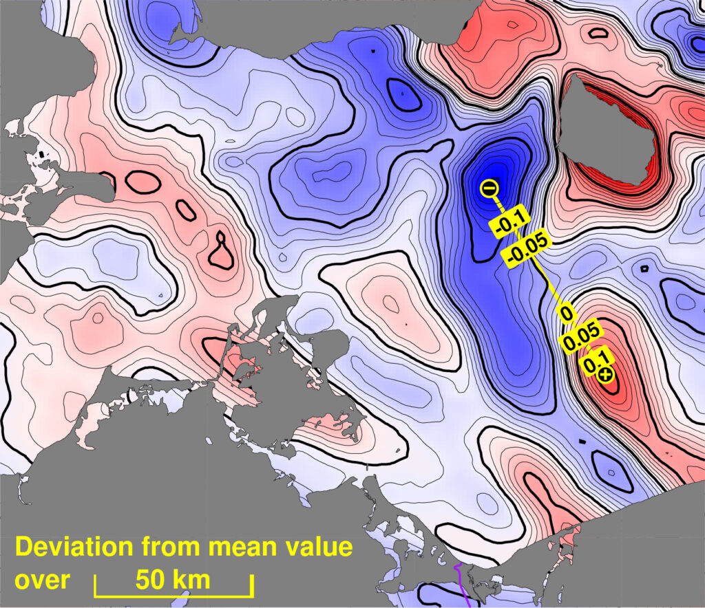
Over the last decades, global geopotential models (GGM) have become available that provide information about the Earth’s gravity field from satellite observations with uniform half-wavelength resolution of down to 100km (Flechtner et al., 2021). The satellite gravity missions GRACE/GRACE-FO (Chen et al., 2021) and especially GOCE (Rummel et al., 2011) were a fundamental step towards a uniform global height system. However, for centimeter accuracy this is still not enough. The short-scale geoid signal, which cannot be obtained from satellite observations, can make up to several decimeters, as demonstrated in Figure 1. Therefore, terrestrial gravity measurements remain indispensable. In the process of regional geoid modeling, these data are combined with the global models. Additionally, digital elevation models are used to estimate the gravitational signals of mountains and valleys at the shortest scales, say, several kilometers, where ever denser gravimetric measurements become too elaborate and costly, or simply impossible in inaccessible areas. In the same way, bathymetric models can provide a significant contribution in areas with rugged sea floor (e.g., fjords, oceanic trenches etc.).
Accurate terrestrial gravity measurements are achieved with the help of special devices called gravimeters, which can be based on various physical principles. In field gravimeters, quartz or metal springs are used like a weighing scale in order to determine gravity differences between points. Absolute gravity values are obtained by free-fall experiments, measuring time and distance of a falling probe in a vacuum chamber. Nowadays, even tiny clouds of atoms close to the absolute zero temperature are used for this purpose. For the GCG, gravity data have been collected over decades by BKG or were provided by various authorities and organizations at national or federal state level, universities, geophysical exploration etc. (see Acknowledgement).
Regarding dynamic platforms, such as airplanes, ships and cars, modern instruments consist of spring gravimeters on gyro stabilized platforms (e.g., Lu et al., 2019; Förste et al., 2020; Ince et al., 2020) or inertial accelerometers (strapdown gravimetry, e.g., Becker, 2016; Johann et al., 2019; Johann et al., 2020). Highly accurate and reliable GNSS positioning and sophisticated filtering strategies are needed in the data postprocessing in order to reduce noise and the disturbing kinematic accelerations from the gravity signal.
5. GRAVIMETRIC MEASUREMENT CAMPAIGNS IN THE GERMAN EEZ
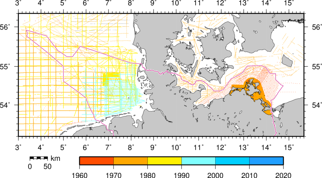
Apart from methodological developments through more efficient algorithms and software, the quality of the input data is the main driver for more accurate and more reliable geoid models. The computation of a geoid model implicates certain requirements to the quality and spatial density of the gravity data. When starting the works on the GCG, the databases had larger gaps in some places of the German EEZ (Figure 2). Part of the available data was more than 50 years old and did not suit today’s requirements regarding accuracy and georeferencing (in particular height). The heterogeneity of these historical datasets is characterized by biases, noise or other blunders, both between different campaigns and internally, causing significant outliers in the statistics of crossover differences.
Therefore, there was a high demand for extensive new gravity measurements, not only to close data gaps but also to validate and, if possible, correct the existing data to a new reference. In the last 15 years BKG focused on improving the data situation in the maritime areas of the German EEZ. While on land static observations are possible, out at sea one has to adapt to the dynamic conditions onboard a moving platform such as a ship or an airplane.
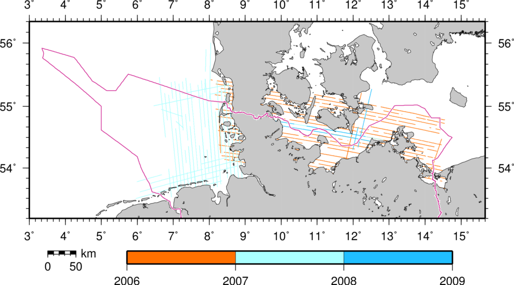
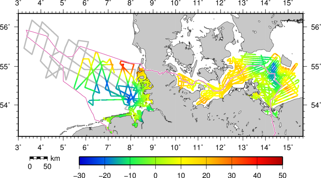
First airborne campaigns were carried out over the Baltic Sea (2006, supplemented in 2008) and the North Sea (2007) in cooperation with the Danish National Space Center (DNSC, now DTU Space) (Skourup et al., 2009; Schäfer et al., 2010). This provided a somewhat complete coverage except for more distant parts of the German EEZ in the North Sea (Figure 3). However, even using the most advanced techniques, it turns out that the accuracy of shipborne measurements still outperforms that of airborne measurements by a factor of 3–5 in terms of standard deviation and maximum differences. Thus, in order to ensure centimeter accuracy for the geoid, shipborne campaigns are still needed.
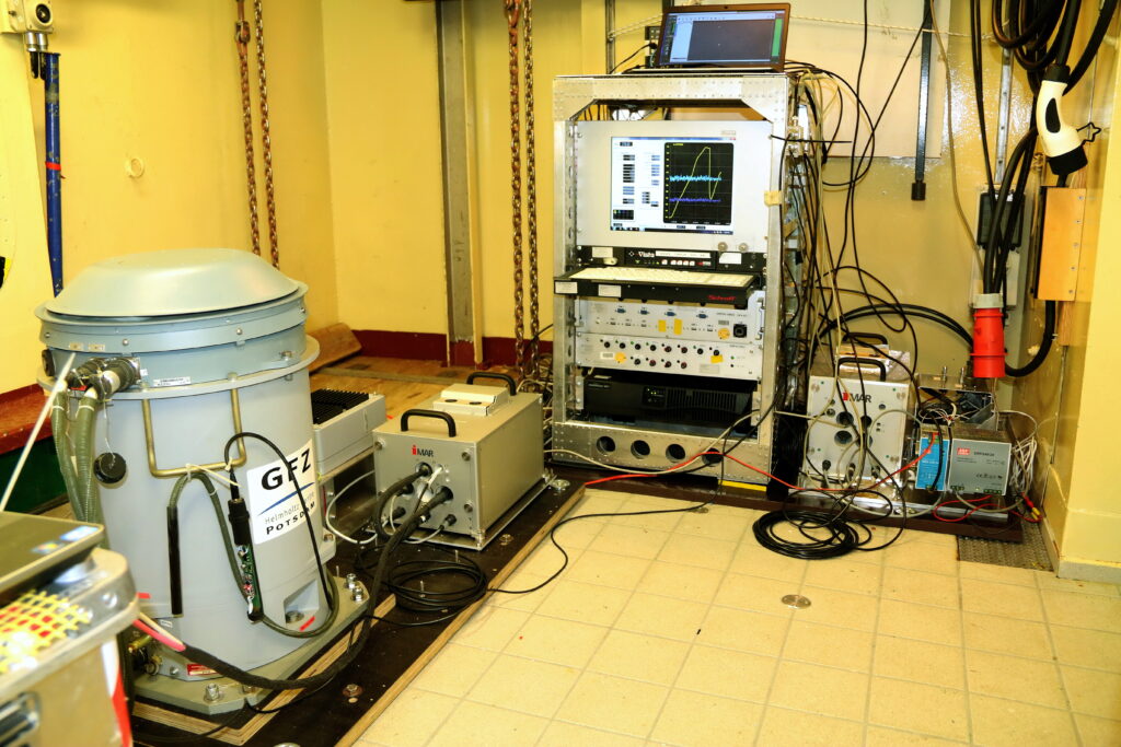
Consequently, since 2013 a total of seven shipborne campaigns have been carried out in the North Sea and the Baltic Sea in cooperation between BSH, the GFZ German Research Centre for Geosciences, and BKG (Figure 4). While the BSH provided one of their survey vessels to sail the profiles planned by BKG, GFZ operated their gravimeter Chekan-AM manufactured by CRSI Elektropribor (St. Petersburg, Russia) and did the postprocessing of the gravity values. Final analyses and editing, including drift modeling and outlier detections where needed, were then done again at BKG. Since 2017, an additional strapdown measurement system manufactured by iMAR Navigation GmbH (St. Ingbert, Germany) was run by TU Darmstadt to provide redundancy. Figure 5 shows the installation of the hardware in the laboratory room of one of the used ships.
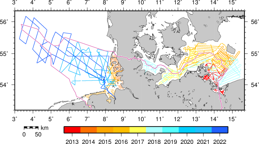
Part of the works between 2015 and 2018 was co-funded through the EU project “Finalizing Surveys for the Baltic Motorways of the Sea” (FAMOS; Schwabe et al., 2020; Förste et al., 2020). The financial support enabled some national authorities to carry out extensive shipborne measurements in the first place for most parts of the Baltic Sea:
- Lantmäteriet and Swedish Maritime Administration (SMA), partly together with Finnish Geospatial Research Institute (FGI), Finnish Transport Agency (FTA) and Geological Survey of Finland (GTK), have carried out measurements all along the Swedish coast and up to the Gulf of Bothnia and the Gulf of Finland between 2015 and 2020.
- DTU Space performed gravimetric measurements onboard regular ships on opportunity basis.
- GFZ has also conducted measurements along long lines onboard large ferries in the Baltic Sea between the harbors of Lübeck (Germany), Liepaja (Lithuania, 2017) and Helsinki (Finland, 2018), respectively (Ince et al., 2020).
- In addition to but outside of the FAMOS project, Gdansk University of Technology (GUT) together with the Hydrographic Office of the Polish Navy (HOPN) started gravimetric activities in Polish waters in 2019.
But just as importantly, the project fostered the collaboration between the international partners. Exchange of expertise and closely coordinated campaigns across borders resulted in even better data quality.
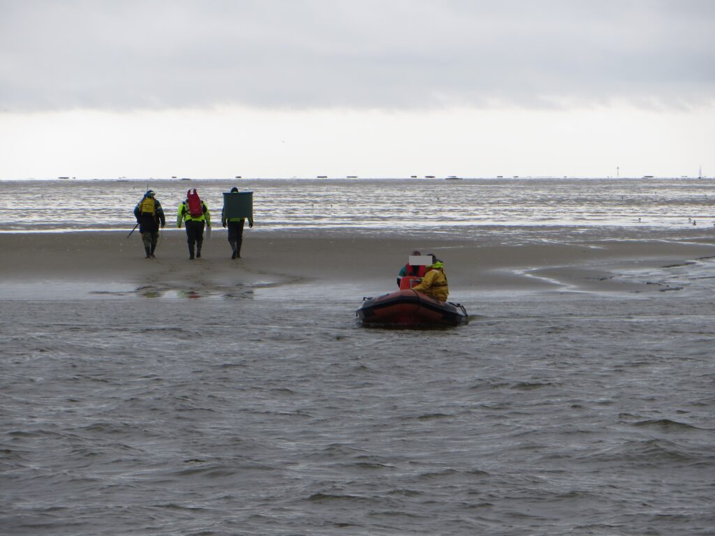
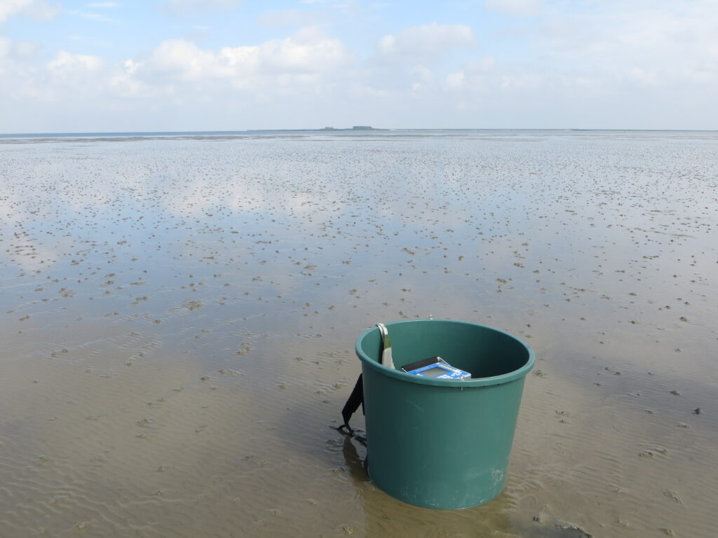
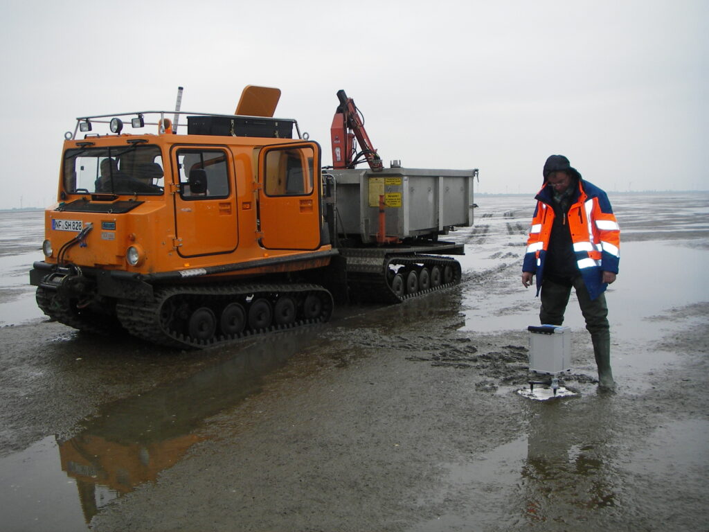
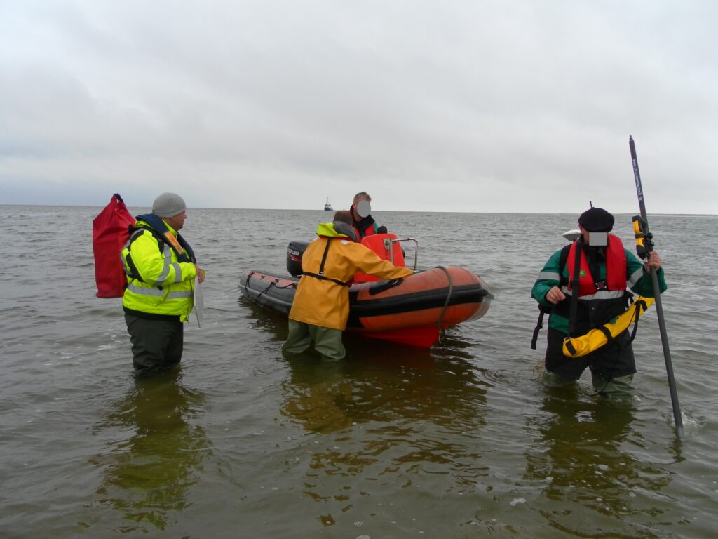
A distinctively challenging target area for fieldwork is the Wadden Sea including the surrounding shallow waters which are inaccessible to both regular survey vessels and the usual survey logistics on land. Therefore, special efforts were taken in 2014 and 2015 to carry out measurements in these areas during low tide. This involved dedicated means of transport (tractors, boats, walking) with experienced guides and logistical support from the local authorities (see Acknowledgement), as well as a modified hardware setup (Figure 6). Additionally, a survey on the smaller survey ship Oland provided by the Schleswig-Holstein State Office for Coastal Protection, Natural Reserve and Marine Conservation (LKN.SH) in 2015 helped to close the gaps adjacent to the North Frisian islands.
6. PRACTICAL ASPECTS AND CHALLENGES OF THE SHIP SURVEYS — NOT A ROUTINELY TASK
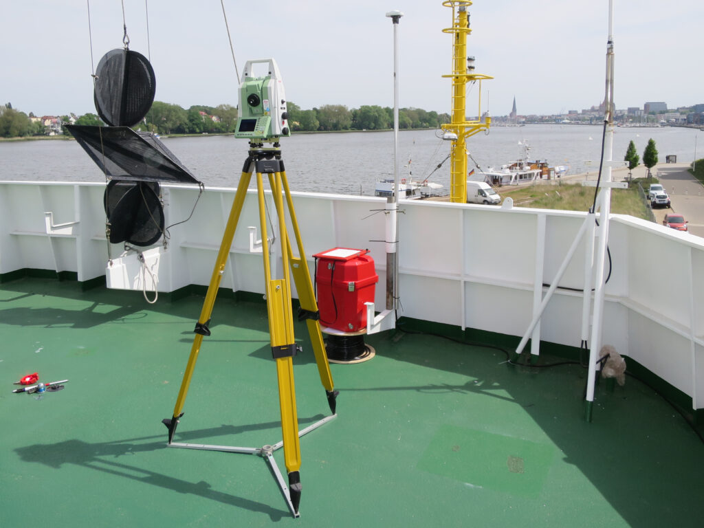
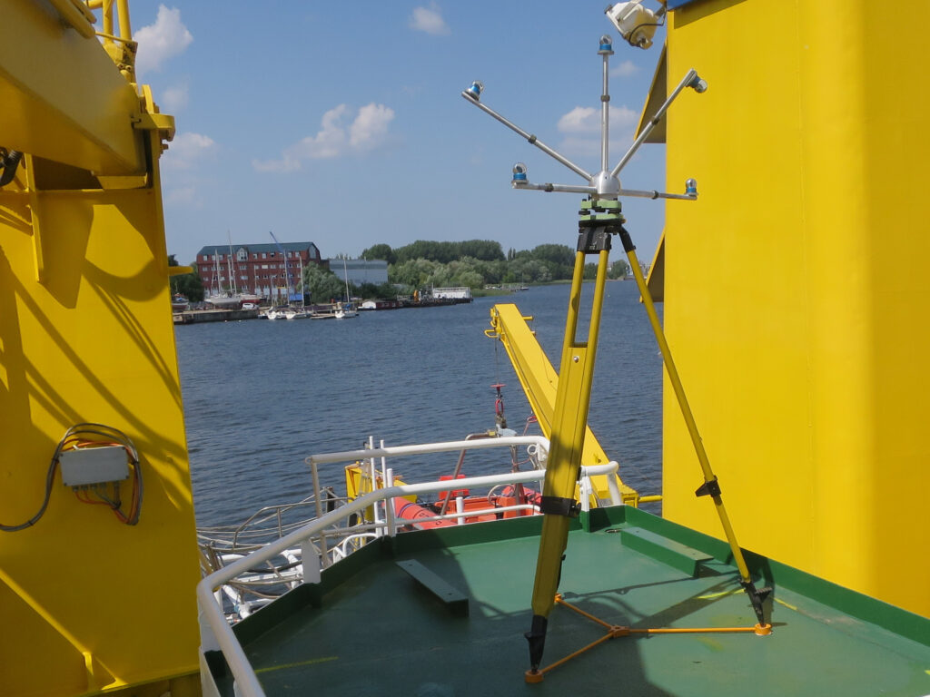
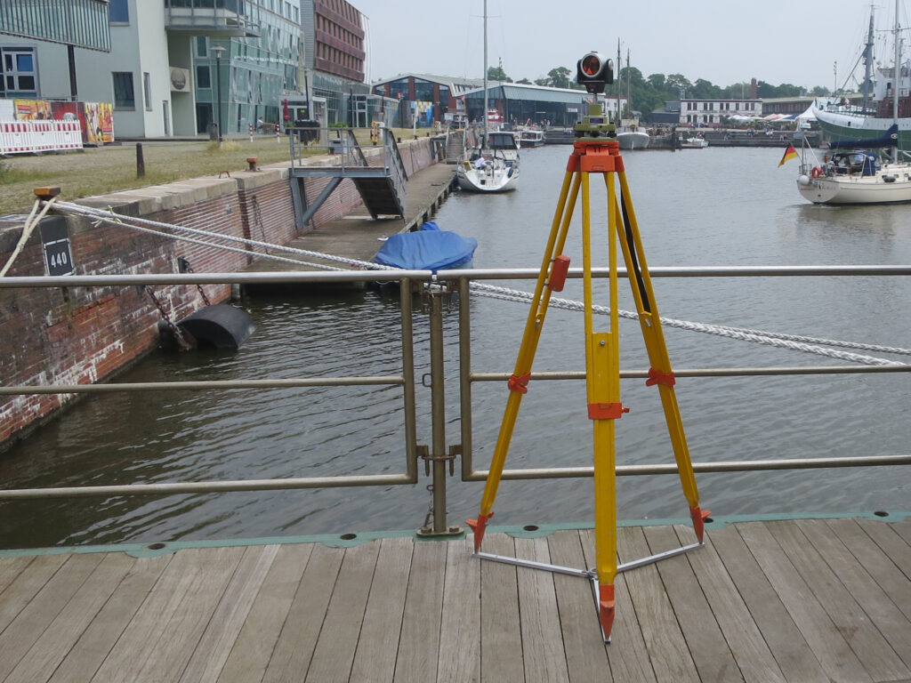
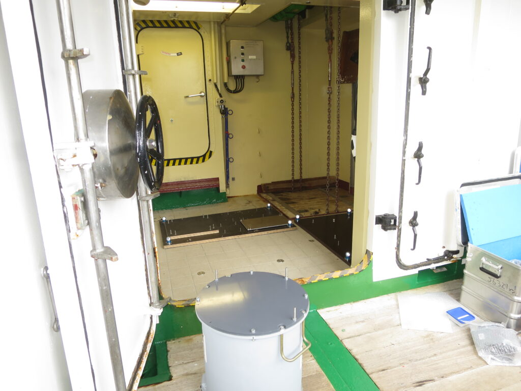
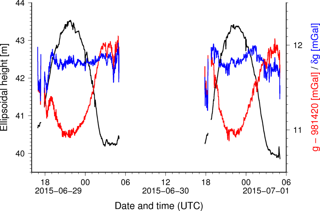
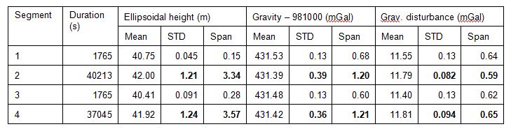
Measuring gravity onboard a ship is not as simple as just to install and switch on a sensor and a data logger. Sea gravimeters deliver relative measurements with a certain drift. Therefore, some additional geodetic work is inevitable. The readings must be connected to reference gravity values in the harbors. Still, a gravity value itself is of no use without proper georeference, in particular an ellipsoidal height accurate to the decimeter. This means that the GNSS trajectory of the sensor has to be precisely and reliably tracked and computed in postprocessing. To this end, the location of the instruments with respect to multiple GNSS antennas, and ideally also the internal inertial navigation system of the used vessel, were precisely surveyed during the installation of the equipment. Figure 7 gives some impressions of these local tie measurements onboard BSH’s survey, wreck search and research vessels VWFS DENEB and VWFS WEGA. During the campaign, careful leveling to the gravity benchmark at the pier as well as comparison with a tide gauge provides additional valuable control of the GNSS trajectory. This all helps to keep biases and harbor residuals of the processed gravity at the level below 0.3 mGal, which roughly maps into 3 mm in terms of the geoid height. An example for the impact and reduction of the tidal signal in a harbor is shown in Figure 8 and Table 1.
Still, the measurements are sensitive not only to the variations of gravity but to all accelerations due to the movement of the vessel. Obviously, the vertical component is again the most relevant one. The magnitude of these kinematic accelerations is several orders of magnitude larger than the actual gravity signal, yet on much higher frequencies. Thus, they can be effectively reduced by special filter techniques (Lu et al., 2019).
Nevertheless, larger turbulences or sudden maneuvers can still cause artefacts (peaks before filtering, oscillations after filtering) that have to be treated as outliers in the postprocessing. This particularly holds for the spring gravimeters. The strapdown technique based on inertial sensors is generally less sensitive to these effects, in turn it is appears to recover slightly smoother gravity with little more fluctuations in the drift at the 1–2mGal level (Johann et al., 2020; Figure 7).
However, first preparations for such an endeavor start long before. About half a year before, measurement profiles have to be planned based to the existing datasets to be controlled, and also in accordance with navigational restrictions such as traffic separation schemes (TSS), prohibited areas, shallows and other obstacles, etc. Since gravimetry, compared to bathymetry, requires not as dense but much longer straight profiles as well as crossover lines, this can be a challenging task. Moreover, since the BSH fleet is legally treated as governmental vessels, permissions have to be applied for in due time through the official diplomatic channels in case that maritime borders are crossed. All these arrangements are made in close contact and with the support from the BSH head office and the designated captain. Still, even the best schedule is not set in stone. Wind, waves and other unforeseeable events may compel situational changes at short notice (Liebsch et al., 2021).
7. RESULTS
Successful gravity field surveys with the support and in close cooperation of many institutions over the last decade are the valuable groundwork for the improvement of the German Combined Quasigeoid and the GNSS-based height determination in the German EEZ. And this work is still not finished. While the activities in the Baltic Sea were completed in 2018, the North Sea still needs some more attention. The most recent data analysis of the 2022 campaign is still pending. Preparations for another survey in 2023 have already started. Some void areas remain to be filled before the existing dataset (see again Figure 2) can be finally analyzed and revised.
The data collected so far provide a comprehensive picture of the gravity field in the German EEZ, as shown by the gravity disturbances2 in Figure 9. Since bathymetric depths respectively depth changes of the area are small, the field is dominated by geological structures.
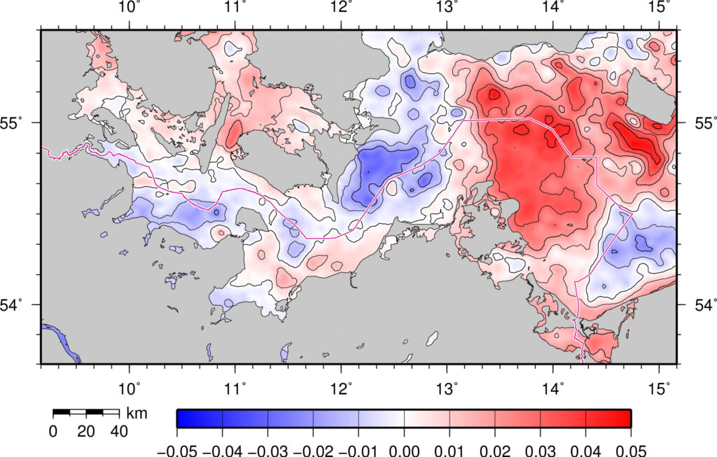
Let us consider once more Figure 1 showing the maritime geoid signal at regional and local scales in the border triangle between Denmark, Poland and Germany based on the current GCG2016. This area features the largest variations at these scales within the German EEZ. The largest “bumps and dents” amount to 10–15 cm due to strong subsurface geophysical features. At the same time, the accuracy and reliability of the available geoid models in this area was limited to the decimeter due to the lack of precise marine gravity data so far. Figure 10 gives an impression of the impact of the new measurements. Thanks to the coordinated multi-national gravimetric campaigns in the framework of BSCD2000 and the FAMOS project, the height reference surface for this area can now be computed with unprecedented accuracy and reliability, i.e., one or two centimeters.
8. SUMMARY AND OUTLOOK
Motivation for this article is the promotion of the geodetic infrastructure for bathymetric surveys and 3-D navigation as well as the work for its improvement in the German Exclusive Economic Zone of the North and Baltic Sea over more than one decade. Geodetic infrastructure means common cross-border geodetic standards, reference systems and frames, models and services.
The BSCD2000 as a new, geoid-based chart datum for the Baltic Sea underlines the significance of the geodetic standards and infrastructure for modern hydrographic surveying and navigation. Upcoming models, applications and services (GNSS positioning services and height reference surface, water level forecasting, etc.) according to the S-100 Universal Hydrographic Data Model (IHO, 2022) require a consistent and interoperable geodetic height reference across borders, which is only possible if harmonized standards are implemented by national law. It is planned by the CDWG to approve and release the first version of the BSCD2000 geoid in 2023. An update may follow around 2026/2027 in accordance with the BSCD2000 roadmap (CDWG, 2022).
Substantial measurement technologies for the geodetic infrastructure are the global positioning satellite systems and other Earth observing satellites as well as terrestrial surveys. A somewhat hidden yet substantial role for height determinations is played by gravimetric surveys needed to compute our height reference surface, the geoid. Since 2013, an almost complete gravimetric survey in the German Exclusive Economic Zone has been carried out by BKG and its partners. By reporting about the fieldwork and its background we gave insight to this successful project over more than one decade.
The gradual improvement of the gravimetric database was one urgent task in order to pave the way for more accurate and more reliable geoid models. This was particularly true for the marine areas since technology and logistics create specific challenges for gravimetric measurements. The quality of the next version of the national height reference surface, the German Combined Quasigeoid (GCG), will be significantly improved thanks to the expertise, logistics, support and good cooperation of many partners. GCG and BSCD2000 are part of the geodetic infrastructure for bathymetry and 3-D navigation in the German Exclusive Economic Zone of the North and Baltic Sea. They make GNSS height determination more efficient and open it for new applications.
9. ACKNOWLEDGEMENTS
These achievements would not have been possible without the logistical support of numerous people and organizations, too many to explicitly name them all. Our hope is that everyone involved feels addressed by this acknowledgement.
The initial idea for the shipborne surveys was born with Dr.-Ing. Wilfried Ellmer (now retired) of German Federal Maritime and Hydrographic Agency (BSH). Logistical and technical support was provided by BSH’s vessel operation and IT units, and of course the captains and the crews of the vessels VS CAPELLA, VWFS DENEB and VWFS WEGA.
The Helmholtz Centre Potsdam – GFZ German Research Centre for Geosciences (GFZ) provided their marine gravimeter equipment and experienced staff for all of the shipborne campaigns.
The Schleswig-Holstein State Office for Coastal Protection, Natural Reserve and Marine Conservation (LKN.SH) and the Schleswig-Holstein State Office for Surveying and Geoinformation (LVermGeo SH) provided logistical support during the Wadden Sea campaign 2014. LKN.SH also provided the survey vessel Oland for the shallow water campaign in 2015.
The Authority for Geoinformation and State Survey of Lower Saxony (LGLN), the Niedersächsischer Landesbetrieb für Wasserwirtschaft, Küsten- und Naturschutz (NLWKN), the German Federal Waterways and Shipping Agency (WSV) with Wasserstraßen- und Schifffahrtsämter (WSA) Bremerhaven, Wilhelmshaven und Cuxhaven as well as the Nationalparkverwaltung Niedersächsisches Wattenmeer provided logistical support during the Wadden Sea campaign 2015.
TU Darmstadt operated their strapdown inertial measurement system during the campaigns onboard Deneb in 2018 (Baltic Sea), 2021 (North Sea) and onboard Wega in 2022 (North Sea) and provided processed data.
iMAR Navigation GmbH St. Ingbert provided another strapdown inertial measurement system of type iCORUS-2 for the campaign onboard Wega in 2022 in the North Sea.
Further sources of gravity data for the GCG and the BSCD2000 geoid in the German EEZ are the geodetic and geological authorities of the German federal states and of the neighboring countries, the Institute of Geodesy (IfE) at Leibnitz University Hannover (LUH), the Federal Institute for Geosciences and Natural Resources (BGR), exploration geophysics via the Lower Saxony Soil Information System (NIBIS), DTU Space (Lyngby, Denmark), Gdańsk University of Technology (GUT, Gdańsk, Poland), and many more.
Finally, internal support within BKG including gravimetric fieldwork and surveying of the vessel was provided by the respective field parties of the units “Gravity Metrology” and “Integrated Spacial Referencing”, while real-time data communication was implemented in cooperation with the “Observing Networks” unit.
10. REFERENCES
Ågren, J., Liebsch, G., Mononen, J. (2021). Specification of the Baltic Sea Chart Datum 2000 (BSCD2000). Version 5b, 21 Sep 2021, http://www.bshc.pro/media/documents/CDWG/CDWG+Specification+of+the+Baltic+Sea+Chart+Datum+2000.pdf, viewed 11 Aug 2022.
BKG (2019). https://evrs.bkg.bund.de, viewed 11 Aug 2022.
BKG (2022). https://www.bkg.bund.de/EN/About-BKG/Geodesy/Information-systems-and-Projects/EN_DACH_EAlpG_Details.html, viewed 11 Aug 2022.
BSH (2021). Notices to Mariners. Official Maritime Publication, Vol. 152, Part 3, p. 3.1.
Becker, D. (2016). Advanced Calibration Methods for Strapdown Airborne Gravimetry. Dissertation, TU Darmstadt, 2016. Veröffentlichungen der DGK, Reihe C, 779. Verlag der Bayerischen Akademie der Wissenschaften, München 2016, ISBN 978-3-7696-5191-1, https://dgk.badw.de/fileadmin/user_upload/Files/DGK/docs/c-779.pdf, viewed 11 Aug 2022.
CDWG (2022). http://www.bshc.pro/media/documents/CDWG/CDWG+RoadMap.pdf, viewed 17 Aug 2022.
Chen, J., Cazenave, A., Dahle, C., Llovel, W., Panet, I., Pfeffer, J., Moreira, L. (2021). Applications and Challenges of GRACE and GRACE Follow-On Satellite Gravimetry. Surveys in Geophysics, 43 (1), 305-345, https://doi.org/10.1007/s10712-021-09685-x.
Ekman, M., Mäkinen, J. (1991). The deviation of mean sea level from the mean geoid in the Baltic sea. Bulletin Géodésique 65, 83-91, https://doi.org/10.1007/BF00806362.
Ekman, M., Mäkinen, J. (1996). Mean sea surface topography in the Baltic Sea and its transition area to the North Sea: A geodetic solution and comparisons with oceanographic models. Journal of Geophysical Research: Oceans, 101 (C5), 11993-11999, https://doi.org/10.1029/96JC00318.
Flechtner, F., Reigber, C., Rummel, R., Balmino, G. (2021). Satellite Gravimetry: A Review of Its Realization. Surveys in Geophysics, 42 (5), 1029-1074, https://doi.org/10.1007/s10712-021-09658-0.
Förste, C., Ince, E. S., Johann, F., Schwabe, J., Liebsch, G. (2020). Marine Gravimetry Activities on the Baltic Sea in the Framework of the EU Project FAMOS. Zeitschrift für Vermessungswesen 145 (5), 287-294, https://doi.org/10.12902/zfv-0317-2020.
Ihde, J., Mäkinen, J., Sacher, M. (2007). Conventions for the Definition and Realization of a European Vertical Reference System (EVRS) – EVRS Conventions 2007. Version 5.2. IAG SC1.3 EUREF Technical Report, https://evrs.bkg.bund.de/SharedDocs/Downloads/EVRS/EN/Publications/EVRFConventions2007.pdf, viewed 11 Aug 2022.
IHO (2022). https://iho.int/en/s-100-based-product-specifications, viewed 17 Aug 2022.
Ince, E. S., Förste, C., Barthelmes, F., Pflug, H., Li, M., Kaminskis, J., Neumayer, K.-H., Michalak, G. (2020). Gravity Measurements along Commercial Ferry Lines in the Baltic Sea and Their Use for Geodetic Purposes. Marine Geodesy 43 (6), 573-602, https://doi.org/10.1080/01490419.2020.1771486.
Johann, F., Becker, D., Becker, M., Forsberg, R., Kadir, M. (2019). The direct Method in Strapdown Airborne Gravimetry – a Review. Zeitschrift für Vermessungswesen, 144 (5), 323-333, https://doi.org/10.12902/zfv-0263-2019.
Johann, F., Becker, D., Becker, M., Ince, E.S. (2020). Multi-Scenario Evaluation of the Direct Method in Strapdown Airborne and Shipborne Gravimetry. In: International Association of Geodesy Symposia. Springer, Berlin, Heidelberg. https://doi.org/10.1007/1345_2020_127.
Liebsch, G., Schirmer, U., Ihre, J., Denker, H., Müller, J. (2006). Quasigeoidbestimmung für Deutschland. In: GPS und GALILEO – Methoden, Lösungen und neueste Entwicklungen. DVW-Schriftenreihe, 49, 127-145.
Liebsch, G., Schirmer, U., Schäfer, U. (2009). Auf dem Weg zur präzisen Höhenbestimmung mit satellitengestützten Verfahren. LSA VERM – Zeitschrift für das Öffentliche Vermessungswesen des Landes Sachsen-Anhalt, 15 (1), 17-26.
Liebsch, G., Westfeld, P., Förste, C., Schröder, L., Schwabe, J., Bauer, T.B., Stolarczuk, N. (2021). Seevermessung mal anders – Zehn Tage Schweremessungen mit dem VWFS Deneb auf der Nordsee im Juni und Juli 2021. Hydrographische Nachrichten 120, 38-45, October 2021, https://doi.org/10.23784/HN120-05.
Omar, A. H., Md Din, A. H., Hamden, M. H., Mahmud, M. R. (2020). Ellipsoidally Referenced Surveying Technique – A Review of the Current Status and Development of Ellipsoidally Referenced Surveying Technique in the Coastal and Offshore Zones for Hydrographic Survey Practice. International Hydrographic Review (24), pp. 85—102. https://ihr.iho.int/articles/ellipsoidally-referenced-surveying-technique-a-review-of-the-current-status-and-development-of-ellipsoidally-referenced-surveying-technique-in-the-coastal-and-offshore-zones-for-hydrographic-survey/
Lu, B., Barthelmes, F., Li, M., Förste, C., Ince, E. S., Petrovic, S., Flechtner, F., Schwabe, J., Luo, Z., Zhong, B., He, K. (2019). Shipborne gravimetry in the Baltic Sea: data processing strategies, crucial findings and preliminary geoid determination tests. Journal of Geodesy, 93 (7), 1059-1071, https://doi.org/10.1007/s00190-018-01225-7.
Moritz, H. (1988). Geodetic reference system 1980. Bulletin géodésique, 62 (3), 348-358, https://doi.org/10.1007/BF02520722.
Rummel, R., Yi, W., Stummer, C. (2011). GOCE gravitational gradiometry. Journal of Geodesy, 85 (11), 777-790, https://doi.org/10.1007/s00190-011-0500-0.
Sacher, M., Liebsch, G. (2019). EVRF2019 as new realization of EVRS. EVRF2019 Final Report, https://evrs.bkg.bund.de/SharedDocs/Downloads/EVRS/EN/Publications/EVRF2019_FinalReport.pdf, viewed 11 Aug 2022.
Schirmer, U., Denker, H., Ihde, J., Liebsch, G., Müller, J. (2006). A New Combined Height Reference Surface for Germany (GCG05). Poster presentation at the EUREF 2006 Symposium, Riga, Latvia, 14-17 Jun 2006, http://www.euref.eu/symposia/2006Riga/P-01.pdf, viewed 11 Aug 2022.
Schirmer, U., Schwabe, J., Liebsch, G., Denker, H. (2018). Modellierung des Quasigeoides GCG2016. In: Arbeitsgemeinschaft der Vermessungsverwaltungen der Länder der Bundesrepublik Deutschland, Arbeitskreis Raumbezug (Eds.): Die Erneuerung des Deutschen Haupthöhennetzes und der einheitliche integrierte geodätische Raumbezug 2016. October 2018, https://doi.org/10.5675/Raumbezug_2016_Hauptdokument.
Schwabe, J., Liebsch, G., Schirmer, U. (2016). Refined computation strategies for the new German Combined Quasigeoid GCG2016. Poster presentation at the Symposium on Geoid, Gravity and Height Systems (GGHS2016), Thessaloniki, Greece, 19-23 September 2016.
Schwabe, J., Ågren, J., Liebsch, G., Mononen, J., Andersen, O. B., Westfeld, P., Hammarklint, T. (2020). The Baltic Sea Chart Datum 2000 (BSCD2000) – Implementation of a common reference level in the Baltic Sea. International Hydrographic Review, 23, 63-83, May 2020, https://ihr.iho.int/articles/the-baltic-sea-chart-datum-2000-bscd2000-implementation-of-a-common-reference-level-in-the-baltic-sea/.
Skourup, H., Forsberg, R., Sandberg Sorensen, S. F., Andersen C. J., Schäfer, U., Liebsch, G., Ihde, J., Schirmer, U. (2009). Strengthening the Vertical Reference in the Southern Baltic Sea by Airborne Gravimetry. In: Sideris M.G. (eds) Observing our Changing Earth. International Association of Geodesy Symposia, 133. Springer, Berlin, Heidelberg, https://doi.org/10.1007/978-3-540-85426-5_16.
Schäfer, U., Liebsch, G., Schirmer, U., Ihde, J., Olesen, A. V., Skourup, H., Forsberg, R., Pflug, H. (2010). Improving Gravity Field Modelling in the German-Danish Border Region by Combining Airborne, Satellite and Terrestrial Gravity Data. In: Mertikas S. (eds) Gravity, Geoid and Earth Observation. International Association of Geodesy Symposia, 135. Springer, Berlin, Heidelberg, https://doi.org/10.1007/978-3-642-10634-7_59.
Torge, W., Müller, J. (2012). Geodesy. 4th edition. De Gruyter, Berlin, Boston.
12. AUTHORS BIOGRAPHIES
Dr.-Ing. Gunter Liebsch is head of the unit “Integrated Spatial Referencing” at the German Federal Agency for Cartography and Geodesy (BKG), dealing with the German and the European height systems, GREF (GNSS reference station network in Germany) and the national quasigeoid model GCG. He graduated as a geodesist from the Technische Universität Dresden (TUD) in 1990 and finalized his PhD thesis on the processing and use of water level time series for geodetic and geo-dynamic applications in the Baltic Sea in 1997. Email: gunter.liebsch@bkg.bund.de
Dr.-Ing. Joachim Schwabe is a scientific staff member of the unit “Integrated Spatial Referencing” at the German Federal Agency for Cartography and Geodesy (BKG). He graduated as a geodesist from the Technische Universität Dresden (TUD) in 2008 and finalized his PhD thesis on regional geoid modeling in the polar regions in 2015. An opportunity to assist the computations for the quasigeoid model GCG2016 led him to the BKG, where he is now contact person for the GCG models and GNSS-based height determination. Email: joachim.schwabe@bkg.bund.de
Dr.-Ing. Patrick Westfeld graduated as a geodesist in 2005 from TU Dresden (Germany). He conducted research in the fields of photogrammetry and laser scanning and completed his PhD in 2012 on geometric-stochastic modeling and motion analysis. Since 2017, Dr. Westfeld heads R&D at BSH, the German Federal Maritime and Hydrographic Agency. The activities of his section range from conceptual issues pertaining to hydroacoustic and imaging sensor technologies, sensor integration and modeling, algorithmic development up to application-specific implementation and practical transfer in the production environment. Email: patrick.westfeld@bsh.de
Dr. Christoph Förste is a scientific staff member of Department 1 “Geodesy” at the Helmholtz-Zentrum Potsdam, Deutsches GeoForschungsZentrum GFZ. He graduated as physicist from the University Leipzig in 1989 and is working in the field of Geodesy for more than three decades. His scientific foci are satellite geodesy as well as gravimetry. At GFZ he is head of the team “Terrestrial and airborne gravimetry”. He is responsible for GFZ’s current shipborne gravimetry activities in the North and Baltic Sea. Email: foer@gfz-potsdam.de
- The conceptual difference between geoid and quasigeoid, corresponding to the different height system definitions of orthometric heights and normal heights, is a detail at expert level which is only relevant on land at higher elevations. For the main user it is just worth knowing that this is one of the reasons for the beforementioned variations in the height differences between countries.
- The gravity disturbance denotes the difference between the actually observed gravity and the normal gravity generated by the reference ellipsoid GRS-80 (Moritz 1988) in the same point.