


Preamble
This manuscript is a reprint of the original paper previously published in 2007 in The International Hydrographic Review (IHR, https://ihr.iho.int/): Alexander, L., Brown, M., Greenslade, B., and Pharaoh, A. (2007). Development of IHO S-100 – The new IHO geospatial standard for hydrographic data. The International Hydrographic Review, 8(1), 56–162. https://journals.lib.unb.ca/index.php/ihr/article/view/20782
1 Introduction
The International Hydrographic Organization (IHO) is an intergovernmental consultative and technical organization established in 1921 to support the safety of navigation, and to contribute to the protection of the marine environment. IHO Special Publication 57 (IHO S-57) is the IHO Transfer Standard for Digital Hydrographic Data. It is the standard intended to be used for the exchange of digital hydrographic data between hydrographic offices, and for the distribution of hydrographic data to manufacturers, mariners and other data users (e.g., environmental management organisations). It was developed so that the transfer of all forms of hydrographic data would take place in a consistent and uniform manner. To date, S-57 Edition 3.0/3.1 has been used almost exclusively for encoding Electronic Navigational Charts (ENCs) for use in Electronic Chart Display and Information Systems (ECDIS). However, there are changing requirements, customers and technology for hydrographic data and as S-57 is intended to support all types of hydrographic data, not solely ENCs, it needs to be expanded in order to accommodate these new requirements.
This information paper explains what is planned in regard to the next edition of the standard. In particular, it provides a brief description of how the standard will be aligned with geospatial standards under development by the International Organisation for Standardisation (ISO) and the benefits to be gained for IHO and its stakeholders.
2 History of S-57
IHO S-57 was formally adopted as an official IHO standard at the XIVth International Hydrographic Conference in May 1992. It includes:
- A general introduction with list of references and definitions
- A theoretical data model on which the standard is based
- The data structure and format that are used to implement the data model General rules for encoding data into the ISO 8211 encapsulation
In addition to the main document, there are two appendices:
Appendix A is the Object Catalogue. It provides the official, IHO-approved data schema that can be used within an exchange set to describe real-world entities.
Appendix B contains the IHO-approved Product Specifications. These contain additional sets of rules for specific applications. Currently, the only product specification in S-57 that is in wide use is for an Electronic Navigational Chart (ENC). A product specification for an IHO Object Catalog Data Dictionary was also included but for all practical purposes has never been implemented.
Edition 3.0 was released in November 1996. Edition 3.1 containing minor revisions/additional attribute values was issued in November 2000. Currently, S-57 3.1 is “frozen”. It will remain valid – in perpetuity – until no longer required.
3 Current limitations of S-57 Edition 3.1
Although S-57 Edition 3.1 has many good aspects, it does have certain limitations:
- It was primarily developed to meet the ENC requirement called for in an IMO-compliant ECDIS.
- It has an inflexible maintenance regime. Freezing standards for lengthy periods is counter-productive.
- As presently structured, it cannot support future requirements (e.g., gridded bathymetry or time-varying information).
- Embedding the data model within the encapsulation (i.e., file format) restricts the flexibility and capability of using a wider range of transfer mechanisms.
- It is regarded by some as a limited standard focused exclusively for the production and exchange of ENC data.
In order to address these and other limitations, the IHO Committee on Hydrographic Requirements for Information Systems (CHRIS) authorised work to begin on a major revision of Edition 3.1. This revision will result in a new standard that includes both additional content and a new data exchange format. The present intention is to publish a new standard in late 2007 and gain ratification by CHRIS in 2008.
4 New name
During the years that S-57 has been in use, many people have come to regard the IHO S-57 standard and the ENC Product Specification as the same thing. In reality, the ENC Product Specification is actually based on S-57. This resulted in the impression by many within the ENC community that the work on a new standard to support other hydrographic products would radically change the ENC, thus affecting ENC production and ECDIS implementation. This is not the intention.
At the 17th Meeting of CHRIS (September 2005), it was decided that the S-57 Edition 4.0 that was currently under development would henceforth be designated as S-100 (IHO Geospatial Standard for Hydrographic Data). Any product specifications developed using S-100 would follow in an S-10x series as they are produced. Thus, at some future date when an ENC Product Specification based on S-100 is developed, it will be designated S-101.
5 Goal / objectives
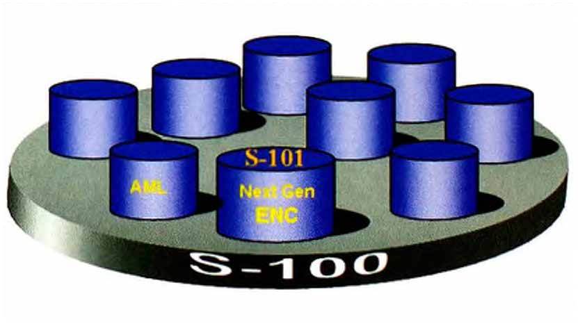
The primary goal for S-100 is to be able to support a greater variety of hydrographic-related digital data sources, products, and customers (see Fig. 1). This includes imagery and gridded data, 3-D and time-varying data (x, y, z, and time), and new applications that go beyond the scope of traditional hydrography (for example, high-density bathymetry, seafloor classification, marine GIS, etc.). It will also enable the use of Web-based services for acquiring, processing, analysing, accessing, and presenting data.
Other goals include:
- Separating the data content from the carrier (file format). In this way, data can be manipulated and encoded without being permanently tied to a single exchange mechanism.
- Manageable flexibility that can accommodate change. Future product specifications will be based on a core data model that may be extended to meet the needs of different hydrographic information communities. This will allow the core standard to evolve (through extension) without the need for producing new versions of existing product specifications.
- An ISO-conforming registry on the IHO Web site containing feature data dictionaries (as registers) and product feature catalogues that are more fleible and capable of being expanded.
- Providing separate registers for other user communities. These will include new features and attributes and additional product specifications that may be created (for example, Nautical Publications, Inland ENC Product Specification, etc).
6 ISO standards for geographic information
The International Organisation for Standardisation (ISO) is a non-governmental international standards organisation comprising a worldwide federation of national standards bodies from over 130 countries. In response to a growing demand for geographic information standards, ISO established Technical Committee 211 (ISO/TC211) in 1994. The aim of ISO/ TC211 is to establish a structured set of standards for information concerning geographic objects or phenomena. IHO, together with many other geographic standards development organizations, is a Class A Liaison Organization to ISO/TC211. Currently, there are over 22 Class A members, including:
- Digital Geographic Information Working Group (DGIWG),
- Global Spatial Data Infrastructure (GSDI),
- Open Geospatial Consortium {OGC),
- United Nations Geographic Information Working Group (UNGIWG).
7 ISO 19100 Standards
The standards developed by ISO/TC211 are contained in the ISO 19100 series of geographic information standards. For all forms of geographic data, these standards specify the methods, tools, and services for:
- Data management (including definition and description),
- Acquiring, processing, analysing, accessing, and presenting data,
- Transferring data in digital electronic form between different users, systems and locations.
In the most general sense, these standards fall into one of the following categories:
- Framework and Reference Model,
- Profiles and Functional Standards,
- Data Models and Operators,
- Data Administration,
- Geographic Information Services.
Currently, there are over 40 standards in the ISO 19100 series. These include both formally adopted and draft International Standards for spatial and temporal schema, metadata, imagery and gridded data, profiles, portrayal, encoding, and so forth.
8 Alignment with ISO/TC211
Given the prominence of ISO standards and their worldwide recognition and use, it makes sense for IHO to adopt the IS0/TC211 suite of standards for S-100.
In 1999, ISO/TC211 invited the IHO and the NATO Digital Geographic Information Working Group (DGIWG) to enter into a cooperative agreement for future standards development. Rather than work at cross-purposes, it was considered prudent to harmonise the data content contained in IHO S-57 (i.e., the Object Catalogue) with that of NATO DIGEST (the DGIWG Feature Data Dictionary – formerly called Feature Attribute Coding Catalog or FACC). Further, the intent was to develop hydrographic standards that were compatible with a broad range of other ISO geospatial standards. This was agreed by the 12th CHRIS meeting in October 2000. Currently members of both organizations attend each other’s meetings and have played important roles in the harmonisation process.
9 New framework
Alignment with the ISO 19100 series of geographic standards will require a different way of organising and defining S-100, compared to S-57. More specifically, it will require a new framework or structure, and a revised set of terms used to describe the components of S-100.
S-100 will consist of a wider range of components than S-57 from which product specifications will be built. These specifications will need to be inclusive and comprehensive in order to enable a more flexible maintenance regime for S-100.
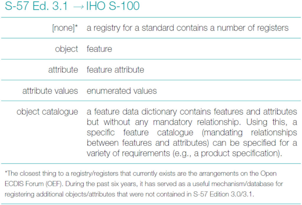
10 Registry component
Perhaps the most significant aspect in terms of alignment with the ISO TC/211 standards is the employment of a “registry” containing one or more “registers” (see Fig. 2).
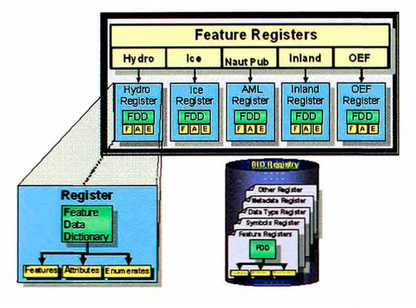
A “registry” is the entire information system (or location) in which a collection of registers is located. In the case of S-100, IHO will host a registry that will provide a facility to store various registers of hydrographic-related information such as feature data dictionaries, data types, and metadata.
Unlike S-57, the feature dictionaries will only consist of the definitions for features, attributes and enumerations. Binding between these definitions, units of measure, format and the like, will be included in a feature catalogue which will be specific to each product specification. Initially there will be registers for Hydrographic Information (based on the existing S-57 feature and attribute catalogues), Dynamic Ice Coverage, Nautical Publications and Inland ENCs. Other types of information that do not fit into these categories can be included in the Open ECDIS Forum (OEF) register. For each register there is an organisation that will be responsible for its content and management. A major benefit of the registry concept is its flexibility. Multiple versions of similar entries in a data dictionary can be maintained using unique identification and classification. For instance, an entry can be classified as being either:
- valid (latest version),
- superseded (previous version/s),
- retired (no longer recommended for use),
- non valid (proposed but not accepted or no longer acceptable).
In this way product feature catalogues can reference an item that will remain valid even if a newer version is registered at a later date. Thus, if a new item is registered, a new version of a current product specification is not required. Non valid items will remain public in order to ensure that any future proposals for similar items have not been previously rejected. An operational registry is planned for early 2007.
11 Framework Component
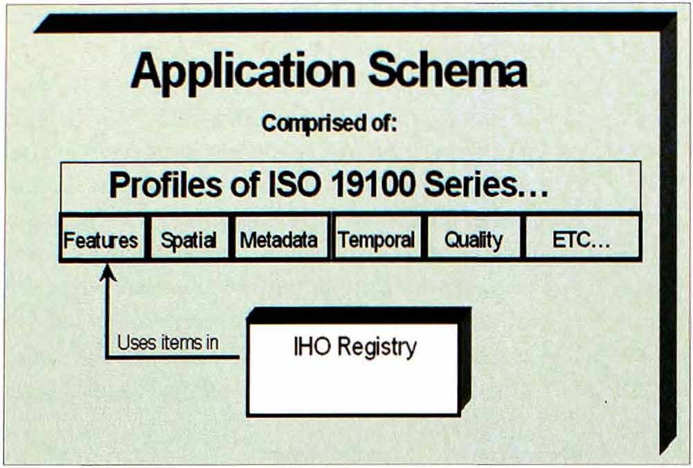
The framework component will be similar to a “cook-book” or “recipe book” demonstrating how different parts of S-100 are selected and used together in the development of product specifications.
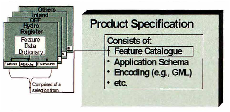
The three most important parts of any product specification are the content model, application schema and encoding model. The content model consists of features, spatial metadata, quality and so forth. The application schema (see Fig. 3) specifies the rules for how the various pieces of the content model are assembled (that is; a feature and its spatial component). These rules can then be applied to develop a product specific application schema that in turn forms the basis of the product specification. Individual product specifications consist of a feature catalogue, an application schema, an encoding (for example, Geographic Markup Language – GML), and so forth, (see Fig. 4).
12 Geometry Component
The one and two-dimensional geometry of S-57 is updated in S-100 to accommodate the use of a wider range of database and encoding applications. For example, the use of a composite curve to amalgamate the individual curve components of a feature will simplify operations on such a feature in the software environment. A new three-dimensional model has also been added.
13 Imagery and Gridded Component
This component defines specific grid organisations to be used for hydrographic data and images associated with hydrographic data. Both simple grids and complex multi-dimensional grids are defined.
Hydrographic soundings are by their nature a set of measured data points. These data points can be represented in a grid structure in several different ways, including elevation models, using a regular grid spacing, and irregular grids with variable size cells or picture elements (pixels) that closely correspond to the handling of soundings as point sets.
Images are also of great importance for hydrographic data. This includes images from sensors such as aerial photography or LiDAR, photographs that can be associated with vector based feature oriented data and scanned paper chart products, commonly known as “Raster Charts”. All of these applications of imagery and gridded data are covered by S-100.
14 Metadata Component
The metadata component is a community profile that provides a specification for describing, validating and exchanging metadata about geographic datasets commonly produced by hydrographic organisations. It is based on ISO 19115 and also takes account of ISO 19139 for the XML implementation.
The profile contains two parts:
Part 1 supports cataloging and discovery metadata and contains the minimum specification for descriptive elements required for hydrographic metadata capture.
Part 2 makes provision for the documentation of more detailed feature and attribute level metadata.
15 New Terminology (IHO S-57® IHO S-100)
Some of the terms and definitions currently used in S-57 Ed. 3.1 will no longer be used. They will be re-defined or will be modified into what some have described as the new language of “ISO-ese”. While this transition may be difficult at first, in the longer term it will be beneficial since IHO S-100 will be using the same language as the ISO TC/211 series of standards.
Some examples of this change in terminology are mentioned in the following table.
16 Benefits
There will be numerous benefits gained from adopting S-100:
- Using ISO-developed components and terminology will help ensure that S-100 and future extensions are in the mainstream of the geospatial information industry. This should also help to facilitate a greater use and lower cost implementation of S-100 for hydrographic and other types of geospatial applications (for example, Marine GIS).
- Conformance with the ISO/TC211 standards will maximize the use of commercial-off-the-shelf (COTS) software applications and development.
- New components of S-100 will not be developed in isolation from the rest of the geospatial information technology community.
- Any new requirements can be incorporated within the established framework of ISO/TC211 based standards.
- Rather than being regarded as simply a standard for hydrography, S-100 will be interoperable with other ISO/TC211 standards and profiles such as NATO DIGEST.
- There are many national standards bodies that will take full advantage of S-100 being aligned with ISO/TC211 standards.
- More than just hydrographic offices and ECDIS equipment will be able to use S-100 based hydrographic data.
- It will facilitate the ability of hydrographic offices to use other sources of geospatial data, for example combining topography and hydrography to create a coastal zone map.
Another improvement will be the way in which ENC data will be encapsulated. In simple terms, encapsulation means the form of data structure used for the exchange of ENC data. The current edition of S-57 uses an outdated ISO standard referred to as ISO/ IEC 8211, “Specification for a data descriptive file for information interchange”. First published in 1985, ISO/IEC 8211 was developed when the state-of-the-art was the 3.5″ floppy disk. ISO/IEC 8211 is no longer widely used, and it would not be possible to efficiently encapsulate some of the new data functionality using this legacy standard. The GIS industry has provided a standards-based format that provides a good replacement for ISO/IEC 8211. The Geography Markup Language (GML) has been developed by the Open Geospatial Consortium, and the current version is progressing to become an ISO standard. Using GML as one method of encapsulating S-100 data fits in well with the overall strategy of using existing standards in order to facilitate acceptance.
17 Migrating from S-57 Edition 3.1 to S-100
ENC data conforming to S-57 Edition 3.1 will continue to be a requirement for type-approved, IMO-compliant ECDIS for the foreseeable future – even after S-100 has been released. As a consequence, hydrographic offices will continue, as at present, to produce Edition 3.1 ENC data to support this.
18 Implications for the ENC Product Specification
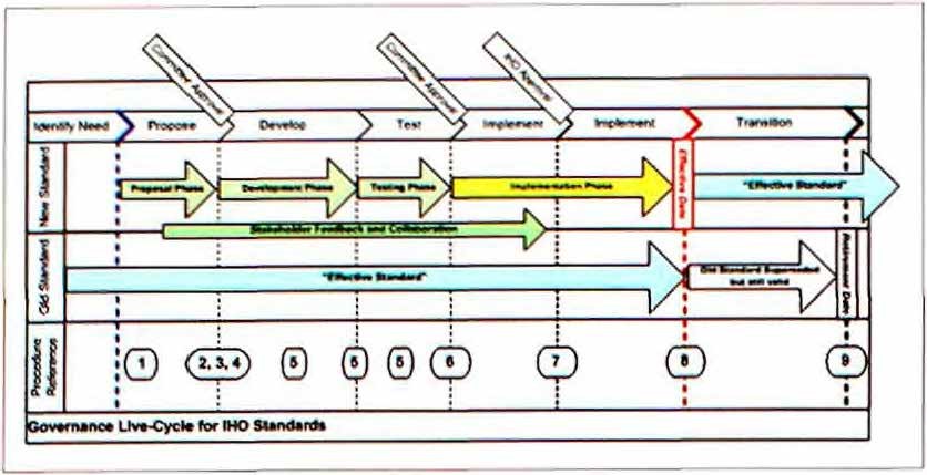
It goes without saying that if any improved ENC Product Specification (such as S-101) is to be adopted in the future, it must provide mariners with useful new functionality. This could include such things as “plug and play” updating of data, symbology and software enhancements as well as the more efficient use of additional data created under S-100. Also, any development of S-101 will be undertaken over several years, and will involve the active participation of all stakeholders, including hydrographic offices, ENC software producers, ECDIS manufacturers, mariners, and other maritime users. The development, implementation and transition into force must also follow the IHO CHRIS governance model for IHO technical standards as illustrated in Fig. 5.
The IHO CHRIS agreed at its meeting in September 2006 that an S-101 Information Paper should be published late in 2007/early 2008 which will explain in detail the proposed content and structure of any future ENC product specification.
As a consequence of the extensive development process, any improved ENC Product Specification (S-101) could not come into force before at least 2012 and even then, the standard would sit alongside the existing S-57 Edition 3.1 Product Specification for some time. Furthermore, it is intended that any ECDIS which are upgraded to use S-101 ENCs will continue to be able to use S-57 Edition 3.1 ENCs as well.
19 In Summary
The primary goal for S-100 is to support a greater variety of hydrographic-related digital data sources, products, and customers. This includes matrix and raster data, 3-D and time-varying data (x, y, z, and time), and new applications that go beyond the scope of traditional hydrography (for example, high-density bathymetry, seafloor classification, marine GIS). It will also enable the use of web-based services for acquiring, processing, analysing, accessing, and presenting data. S-100 is not an incremental revision of Edition 3.1. S-100 will be a new standard that includes both additional content and support of a new data exchange formats.
Due to the worldwide prominence of ISO standards, IHO S-100 will be based on the ISO suite of standards. However, alignment with the ISO 19100 series of geographic standards will require a different structure for S-100 compared to S-57. More specifically, this will involve a new framework, and new/ revised terms to describe the components of S-100.
The present intention is to release S-100 in late 2007. IHO S-57 Edition 3.1 will continue to be used for many years to come – even after S-100 has been released. As such, Hydrographic Offices will continue to produce S-57 ENC data to meet IMO ECDIS Performance Standard requirements, and to maintain world-wide ENC coverage. Any future ENC Product Specification will take several years to develop after publication of the S-100 base standard, and will involve the active participation of all IHO stakeholders.