
Abstract
1 Lifting the clouds for a CLEAR future
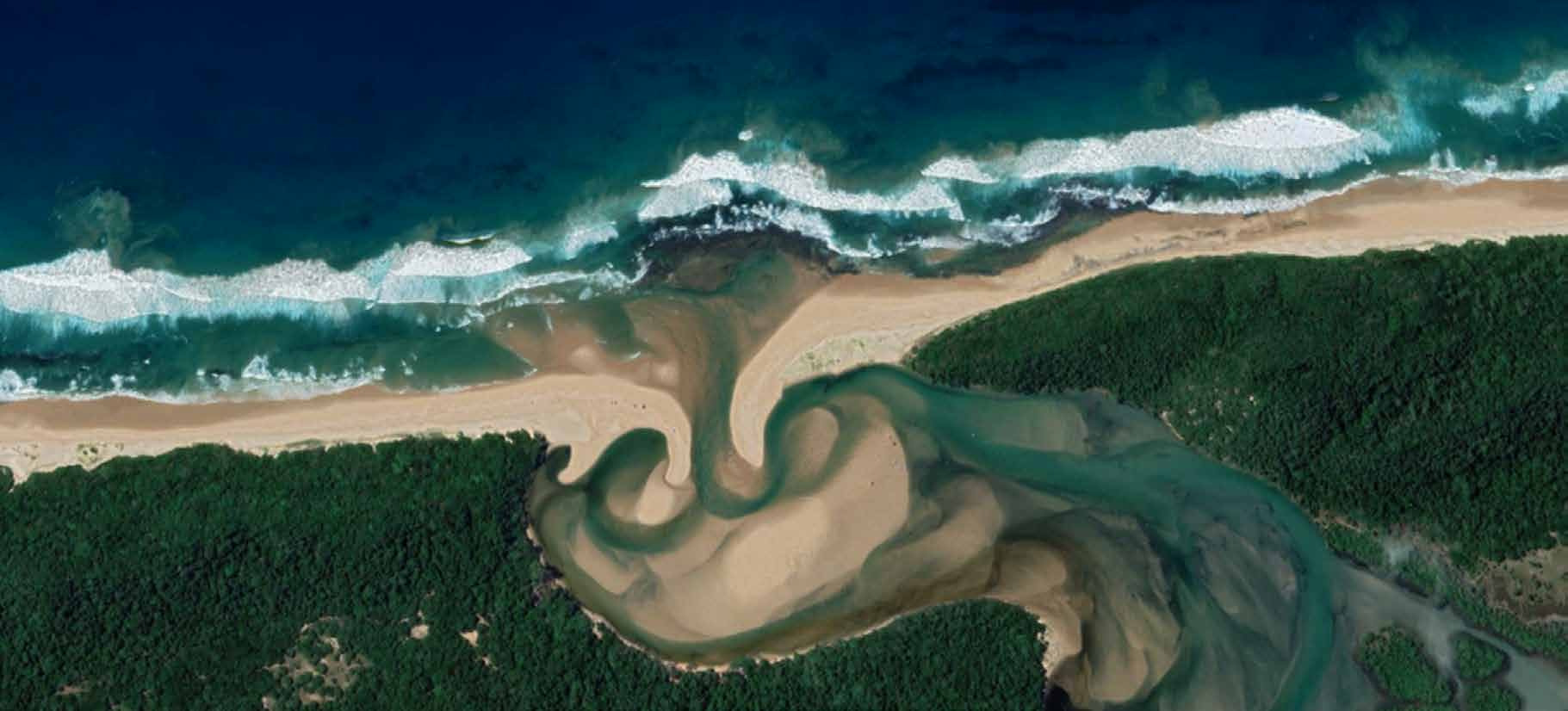
Many years ago, as a young graduate student at the University of Cape Town, I was fortunate enough to help another graduate student with her research on shellfish population dynamics in the Kosi Bay region of South Africa, located in the northeastern part of KwaZulu Natal province (Reaugh, 2006; Fig. 1). Rocky nearshore reefs in the area were home to a local subsistence and artisanal fishery that was under threat due to over-harvesting and the need to provide quality protein food to a growing population of residents.
Over a period of several years, researchers from the university and members of the KwaZulu Natal provincial government worked with community residents to gain a baseline level of knowledge into the shellfish populations. The comprehensive field research included several aspects of hydrospatial data collection, from bathymetric surveys to sediment sampling, shellfish larvae harvesting and water column chemistry samples. Community members partnered with the provincial government agency to form a locally managed sustainable fisheries co-management council, among the first of its kind in post-apartheid South Africa. The hydrospatial domain inclusive of hydrographic and marine biological research established the scientific basis for what a “sustainable fishery” in the blue economy meant, and the elected representatives of the community together with representatives of the provincial government agency shared the management duties.
While the above retelling is succinct, factually accurate, and feels good to read – everyone likes a success story! – telling the story of the Songimvelo (“Let Us Conserve” in the isiZulu language) Mussel Committee in this way does a profound injustice to all the people who were involved in its creation. The foundation research took place in a region whose residents historically had extremely good reasons to be suspicious of and hostile towards government interventions, in a time of great political and governmental change in South Africa, and with a pressing need to address the immediate future of the fishery itself to prevent its collapse. The university researchers and government officials spent close to a year on outreach and engagement efforts before finding a coastal community whose residents were willing and able to engage with the lead researcher and other members of her team. This represented a major leap of faith on the community’s part as only a few years before, the provincial government agency could arrest and jail people for harvesting shellfish in the bay. This also represented a major investment of a valuable resource – time. In a community whose people were living at a subsistence level, time spent having tea and talking with the scientific party was time that could be doing other activities that would put food on their tables.
It took many more months of work with those community residents to explore and understand the historical and cultural fishery practices, especially in engaging with the local women who traditionally harvested the shellfish. The researchers discussed their scientific work with the women of the community, who added their own insights from their years of observing the marine and hydrospatial environment they called home. This again required significant trust on the part of community members: that the information they provided to the researchers and provincial government agency would be used for their benefit. The Songimvelo Mussel Committee could not have happened without this years-long effort from everyone – university professors, graduate students, civil servants, and most importantly the community members themselves – to guide the research, so that it met community needs and not an abstract concept of sustainability in the blue economy.
As a graduate student, I was thrilled to be invited to work in the Kosi Bay projects with my colleagues. Like many students, I was wholly task-driven, on site to use the instruments and make sampling equipment on-site and collect samples. I was also young and did not have much life experience, and in my youth and inexperience I focused my attention in general on scientific work. I assumed that human work was someone else’s job. That assumption clouded my perspective of what I was doing and why I was there, and it clouded my perspective of my own master’s research, in another bay and another ocean on the other side of the country. With time and life experience, I learned that understanding the human dimensions to a scientific question is a fundamental part of designing a successful project. If I want clear eyes to see the problem and a clear mind to understand the complexities of the questions I want to answer, the first step to finding that clarity is to engage and openly communicate with people whose lives and livelihoods depend upon getting that answer right. We do not go to project sites to collect sediment samples and record water column profiles that will go into a storage container or database somewhere and be forgotten, we go to project sites in order to provide expert hydrospatial data and analysis to people who need our support and our services to live safely and with dignity at the boundary of land and sea.
We now know that at least some of the effects of climate change cannot be reversed in our lifetimes. The overall impact is still yet unknown; models give us estimates that are only as good as the initial assumptions. Sea level rise is guaranteed – but how much? Coastal erosion is guaranteed as we face increased flooding and stronger storms – but how much? Groundwater and landmasses uplift or subsidence, nuisance flooding, and tidal range amplification will affect people living in coastal margins and especially around bays – but how much? And while we have the possibility of adaptation and mitigating some of the effects of climate change through offshore carbon capture and storage and offshore renewable energy, how will that affect the 40% of the world’s population living within a 100-kilometer distance of the all the blue of our blue planet and its contiguous zones, the world’s coastlines and hydrospatial domain?
While we do not know what we do not know with certainty how climate change will affect a particular community, we do know that there are things society can do to blunt the effects to those communities to some extent. We call these mitigation tools climate adaptation and climate resilience. Climate adaptation is defined as “the process of adjusting to new (climate) conditions in order to reduce risks to valued assets”, while the definition for resilience is “the capacity of a community, business, or natural environment to prevent, withstand, respond to, and recover from a disruption”. Assigning meanings to words gives us a guide to follow in general, but for any individual community living on the coastal margin, which includes freshwater as well as saltwater coasts, what does it mean to be resilient? What specific problems do we need to address to help a community adapt? We also talk about the Blue Economy, which the United Nations defines as “sustainable use of ocean resources for economic growth, improved livelihoods, and jobs while preserving the health of the ocean ecosystem”. Again, what does that mean? If we consider that definition from a global perspective, we will find ourselves asking a very different set of questions about “what is sustainable” and “how are livelihoods improved” than we would if we were considering small subsistence-level communities. Although there are no one size-fits-all answers to these questions, they are all questions that surveyors, hydrographers, and other hydrospatial scientists can help answer …if we are willing to do the work with the people and communities that are affected.
This statement leads to another question: what does it mean to “do the work”? Community-led engagement is pivotal to building trusted relationships with stakeholders in order to inform, consult, and empower them as part of working towards a longterm goal. Beyond these broad brush strokes, what it means to “do the work” will vary according to the type of community involved and the end goal. The communities might be communities-of-place, who are residents of a geographical area, communities-of-identity, who are people with common affiliations or experiences (such as ethnic background), or communities-of-practice, which are defined by things that they do, such as professional organizations (Reid & Schulze, 2019). Regardless of the specific membership of the community in question, CLEAR: Community-Led Engagement for Adaptability & Resilience engagement will always mean finding the people who are most affected by an issue and elevating them to a position where they can effectively advocate for themselves as respected colleagues if not as equals.
2 Community-led engagement starts at home: CLEAR-ing up IHO policies and standards
In discussing community-led engagement for climate adaptation and resilience, let us begin with our own community: Hydrographers.
For a century, the International Hydrographic Organization (IHO) has been doing community-led engagement for professional hydrographers and navigation experts. Viewed through a CLEAR lens, the Capacity Building and Education committees do continuous community-of-practice engagement: finding out what member states need in order to practice hydrography effectively and in accordance with best practices and help them work up to those levels. Member states receive technical evaluations, training, workshops, and grant funding from the IHO, which in turn assists those member states in meeting the IHO’s long-term objectives. Member states that develop their Hydrographic Office (HO) capabilities to a certain level are then able and encouraged to to assist other member states in the region – bringing them in as peers and partners.
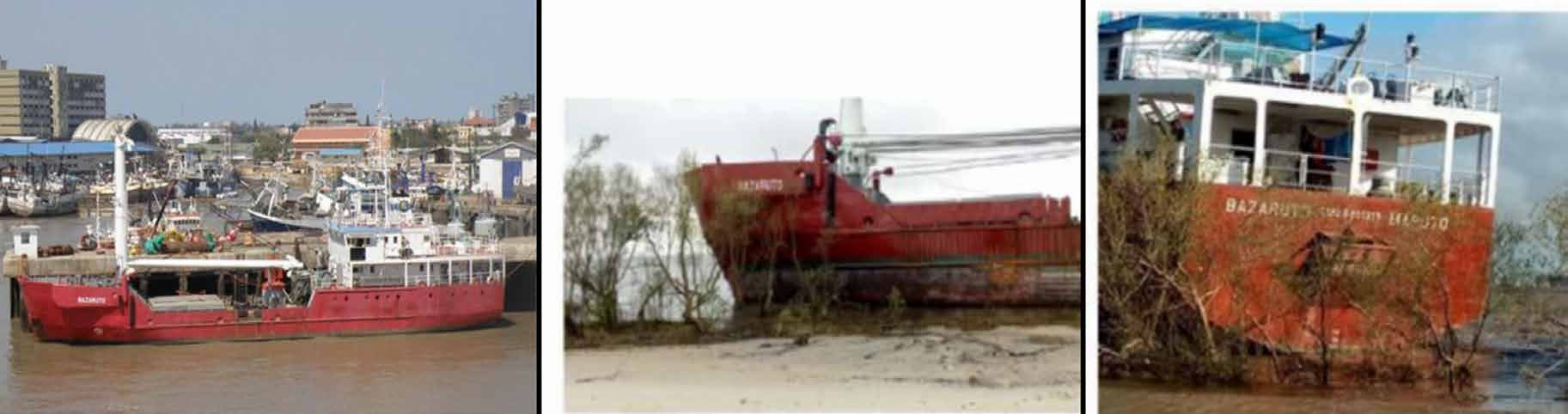
Although the community-of-practice engagement work done by the Capacity Building and Education committees have good engagement processes in place for their respective roles, climate change-related adaptation and resilience will require adjusting those processes or adding new ones. In the May 2020 edition of The International Hydrographic Review journal (IHR), Hydrographers from the Mozambican HO, Institu Nacional de Hidrografia e Navegação, or INAHINA, described the devastating 2019 Intense Tropical Cyclone Idai on their vessels and facilities (Canhanga et al., 2020; Fig. 3). Despite their best efforts to safeguard their vessels and equipment, INAHINA lost a considerable amount of its departmental capacity literally overnight. Sadly, just over a month after Tropical Cyclone Idai made landfall in Beira, the extremely dangerous Intense Tropical Cyclone Kenneth made landfall near the city of Pemba, exacerbating INAHINA’s difficulties.
The INAHINA Hydrographers wrote about their experiences and the lessons they learned from the storm’s passage, including the “need to … develop standard operating procedures where the support from the international community may be of paramount importance” (Canhanga et al., 2020). This specific request shows how a community-of-practice, a community-of-identity, and a community-of-place can intersect: Hydrographers (practice) in Mozambique (place) requested post-disaster Capacity Building activities, preferably delivered in the Portuguese language (identity). A non-governmental body like the IHO will typically engage with a community-of-practice first and foremost, but it must be willing to engage with communities-of-identity or communities-of-place as a means to that end. Understanding the needs of people working for HOs and understanding the needs of HOs as organizations are not interchangeable. This is a CLEAR request for community-of-practice engagement from the IHO, where INAHINA are the community of Hydrographers most affected by the cyclone. This request implicitly acknowledges that community-of-identity engagement is a fundamental part of the overall engagement effort. South Africa and France (through Réunion and Mayotte), the nearest IHO member states and among the first nations to provide emergency aid to Mozambique, have different official languages and cultural practices than Mozambique. It is important for all stakeholders in a regional partnership such as this to be able to understand one another’s languages and cultural practices, and the process of establishing communication roles for different stakeholders is a community-led engagement task.
The INAHINA Hydrographers highlight the need for CLEAR engagement within the IHO itself. If climate change-related events cause a member state HO to lose some or all of its capacity in a short period of time, how do the IHO and other member state HOs support their peer? Certain areas of the world may be well-practiced in this type of cooperation – the HOs of nations bordering the Caribbean Sea have decades of hard-won experience in coordinating navigation safety responses after tropical cyclones – but other HOs or Regional Commissions may need guidance and assistance in developing their own protocols. How do HOs effectively provide guidance to mariners and to the residents of coastal communities? Methods that acknowledge the climate risk, such as assisting member states in building remote survey capacity or cloud-based data handling systems, both of which make the HO less vulnerable to physical infrastructure disruptions, are one way to answer that question. I note that the IHO Capacity Building Committee has added the workshop “P-41: Hydrographic Data Managements to Support Disaster Relief”, which appears to be a CLEAR initiative towards this goal.
CLEAR engagement for climate resilience from a professional governing body requires assessing existing best-practices and procedures and verifying that they still serve the needs of the organization. I recently listened to a discussion about non-contact methods of acquiring bathymetry (such as radar-derived bathymetry) and their suitability for charting. One person advocated for non-contact methods, to which another person responded that soundings from non-contact methods do not meet existing error specifications. This is CLEAR-ly a problem: while there are very good reasons for the IHO to define rigorous error standards for charting, if the practical result of those rigorous standards is that HOs will leave white space or known incorrect soundings on a chart rather than use non-contact methods with lower absolute accuracy but much higher temporal resolution, are we truly acting in the best interests of safe navigation? If the IHO doesn’t make room for methods that give HOs tools to efficiently map previously underserved communities at risk of sea level rise disruptions, such as non-contact radar or satellite-derived bathymetry, are we living up to our goals to support sustainability and resilience?
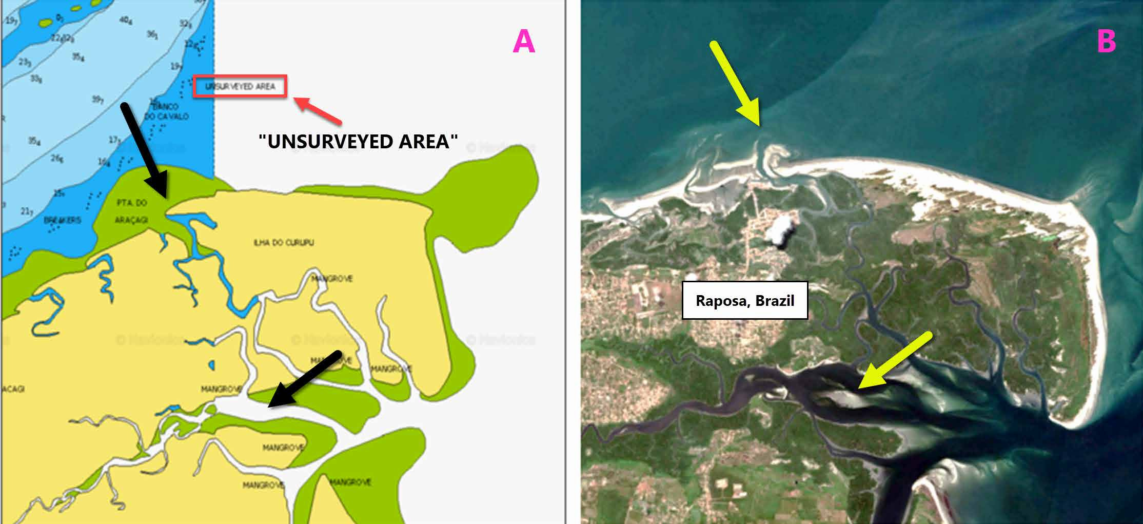
These are not rhetorical questions. The residents of Raposa, Brazil (Fig. 4) are no less deserving of modern Hydrospatial data collection to support safety of life at sea and their ability to mitigate climate risk than residents of Rio de Janiero, but Raposa is the community surrounded by uncharted waters. For all of the capability and wonderful talent possessed by the Brazil Directorate of Hydrography and Navigation (DHN), they have 7,800 kilometres of coastline, the world’s largest navigable inland river system, and several globally important ports in their remit. The DHN must allocate its limited resources while meeting IHO sounding accuracy standards as best as it can, and choosing to focus its efforts on critical navigation areas and energy development are prudent and reasonable decisions. But what if DHN were able to do more? What if a nation like Canada, that also has a well-established HO with a huge territory in their remit, could do more? The IHO could engage with member states to develop standards that accommodate less-accurate non-contact methods, preserving navigational safety and the Blue Economies of Brazil or Canada (or any other member state!) as a whole while also supporting local climate resilience and economic development initiatives. These conversations will be challenging, but with the certainty of seafloor and coastline change and sea level rise, the sooner we start, the better.
3 Supporting community engagement with the IHR
In cases where the primary community engagement needs is community-of-identity or community-of-place, it is not expected that an organization like the IHO itself will be the facilitator in the engagement. Given the importance of these types of engagement, there is still room for the IHO to participate, and one way to engage is via The International Hydrographic Review. The IHR can act as a teaching tool and library for how Hydrographers and Hydrospatial scientists can approach and engage with national to local-scale stakeholders in ways that are practical, tactful, and lead to good scientific understanding of adaptation and resilience for community members. With some forethought, the IHR can support CLEAR initiatives as a teaching tool without putting too much of an extra burden on its editorial staff.
The IHR is already fulfilling this role to some extent, although it is not formally classifying or tagging articles and notes as such. One note from November 2022 discusses intergovernmental cooperation between the Hydrographic Office of Portugal and the Hydrographic Offices of Portuguese-speaking African countries (Delgado Vicente, 2022). Another note from November 2021 discusses the National Oceanic and Atmospheric Administration’s (NOAA) Hydrographic Services Review Panel (HSRP) Federal Advisory Committee in the United States (Mersfelder-Lewis et al., 2021). This panel was designed to be an engagement tool for the national hydrographic office to interact with private-sector and academic stakeholders. One of the HSRP’s stated goals in the article is to “discuss adaptive resilience to climage change, including how NOAA can make an impact in this area”. The seated members of the panel can act as liaisons to their respective industries and solicit analysis and advice from other professionals. Public commentary is both desired and actively sought. These articles both offer insights in how Hydrographic Offices can successfully engage with one another and with other Hydrospatial industry professionals outside of their respective governments. The IHR editorial board could choose to specifically tag these articles as related to community engagement (Fig. 5), and they can consult with the authors to retroactively tag existing articles with a strong community engagement component.
Another area that the IHR can support CLEAR initiatives is by one of the most basic functions of a scientific journal: references. Trust and open communication are important parts of community engagement, and they are both difficult to achieve. By encouraging authors to include references to community engagement projects in their work, such as newspaper articles or publicly-available government proceedings, Hydrospatial scientists going to work in a community will have a better understanding of that community’s needs and a way to open communication with residents before ever going to site or talking to the first person. Scientists can also give references to community members, giving them a means of verifying that what the scientists say is true and that it is likely to be useful to them. As a community member, hearing the concerns of other people like them and seeing the process in action is powerful and empowering, which is our goal. The NOAA HSRP does this by making its proceedings available to the public through a U.S. federal government website (United States Federal Register, 2023). Like adding a new category tag to IHR articles and notes, this is achievable immediately and will have immediate benefit.
Projects that involve community-of-place and community-of-identity engagement are more commonly seen in grey literature (conference papers, minutes of public meetings, etc). This is not entirely surprising, given that a technical journal will want to focus on technical articles. This grey literature is a wealth of information, and authors will have already written at least some material for their presentations. This is an opportunity for the IHR to support its membership in learning how to successfully navigate CLEAR initiatives: publishing a special edition on CLEAR topics. Articles in a special edition need not be vastly different than articles in previous editions: articles about SeaBed 2030, the Empowering Women in Hydrography project, and the NOAA HSRP process all discuss different forms of community engagement. Articles about successful crowdsourcing projects are by definition community engagement projects and should be encouraged. It would be appropriate for officials from HOs in member states already involved in community-led engagement, such as NOAA in the USA and the Canadian Hydrographic Service, be invited to act as peer reviewers. It is also a good idea to specifically invite peer reviewers and CLEAR initiative authors from low or middle-income nations, who will have very different perspectives than people in high-income nations, and from minority or indigenous authors.
4 Supporting CLEAR initiatives through mapping
At its heart, community engagement is creating a framework for storytelling. Community members tell stories about things that are important to them and outline what they need based on those stories. Hydrospatial scientists listen to those stories and requests and use them to develop their research and surveying programmes. The scientific data they find tells a story on its own, and scientists must interpret what the data is telling them and weave it into a set of recommendations. Governing bodies collect these stories and use them to build good policies. The challenge in CLEAR initiatives is to take stories of the past – cultural information, environmental data, community needs – and combine them with stories yet to be written (also known as forecasts and model results) in ways that all participants can meaningfully use. Again, while the IHO as an intergovernmental body will not be involved in local or regional-level CLEAR initiatives, it can support them indirectly through its cartographic activities and support member states who are trying to build their own public-access maps.
Maps condense different types of spatial data into a common, easy-to-understand visual format. Whether they are simple hand-drawn sketches or aesthetically pleasing marriages of science and art, maps are powerful and transformative tools of engagement. Maps can connect local sustainability and climate resilience needs with broader Blue Economy development needs and resources available in the region, and with modern software advances, local community members only need a smartphone or tablet to be able to design their own maps or contribute to existing maps. If a CLEAR goal is to elevate and enable communites to advocate for themselves, maps are perhaps the single best tool to elevate community-of-place members.
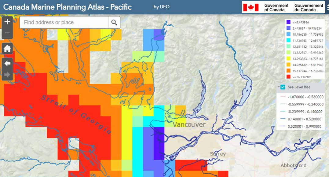
The Department of Fisheries and Oceans Canada (DFO) has recently created interactive online maps for spatial planning and community engagement in Canada. Electronic Nautical Chart (ENC) data in S-57 format (soon to be S-100 format) is available as a layer, as are layers for expected sea level rise and modeled sea surface temperature. These maps assist region planners in determining what specific threats a region will face and what types of coastal protections are necessary. With the ENC data, regional planners can connect land-based climate resilience projects with marine or riverine projects and highlight specific problem areas, such as what might happen if sea level rise causes overwash of an important roadway.
The example shown in Fig. 6 is the lower Fraser River valley, British Columbia, Canada, which experienced a severe flooding event in late 2021. The Nooksack River, visible in the lower right hand corner in the city of Abbotsford, breached levees around the city and forced over 3,000 people to evacuate their homes. City and provincial officials consulted with city residents, an Indigenous community bordering the city to the north, and other stakeholders to determine the preferred flood mitigations (City of Abbotsford, 2022). The map in Fig. 6 shows that the Nooksack River is expected to experience between 0.5 meter to 1 meter of sea level rise under current climate predictions. These predictions, and maps similar to this one, were used in community engagement meetings. The operational debut of S-100 standards offers many more possible ways for stakeholders to use Hydrospatial data than an ENC alone. This is an exciting achievement. As the rollout of S-100 progresses, member states may choose to build public-access maps featuring ENC and Hydrospatial data in order to assist CLEAR initiatives within their national remits. The IHO can encourage and support Hos who want to build their own publicly-available planning maps based on S-100 data by developing a set of best-practices or even a common template for member state HOs to adjust for their unique needs.
5 There are no CLEAR happy endings
The past may be prologue to our lives, but it is not the end. Climate change is here and some of its effects cannot be undone, but this does not mean we are doomed to sit on our hands and do nothing. Quite the opposite: as a community of trained knowledge workers, we have the power to share our knowledge with people who need it and support our peers as they embark upon their own CLEAR initiatives. Through community engagement, we can get better solutions to complex problems and overcome resistance to change. We are our own best advocates, and we are our own best supporters.
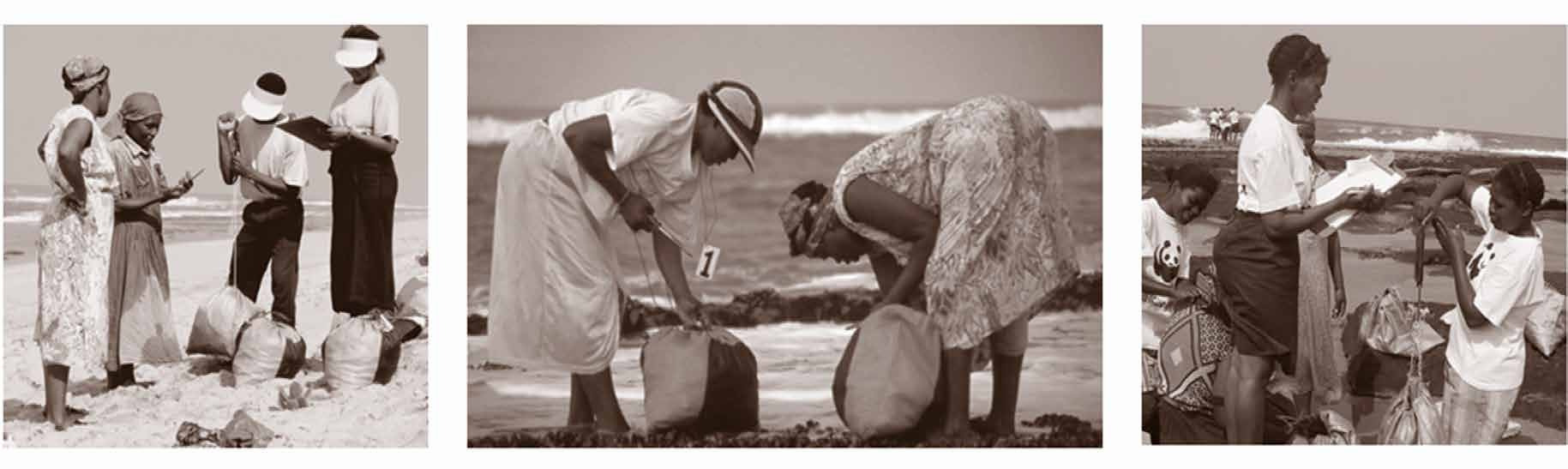
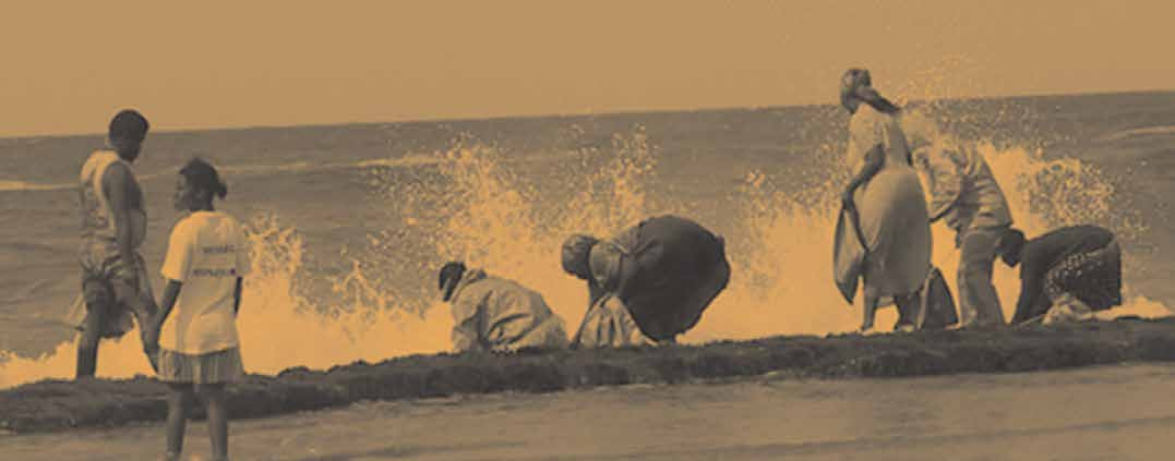
As a final note, the short story version of the Songimvelo Mussel Committee with a happy ending does a further injustice to the participants, for these women’s lives are not a short story and there was no happy ending because their work never stopped (Fig. 7). The local fisheries co-management projects in the Kosi Bay region have had to adapt and change in the past twenty years as they face other changes in the region, particularly from tourism pressures on the fishery and related land use restrictions. Community engagement projects continue to this day. Nonetheless, with regards to the scientific research, the future of the food resource is a success story. The kind of work I have outlined for the IHO itself, the IHR, and individual member states likewise will not stop. We can write our own stories, though, and draw our own maps. We can build our own CLEAR futures with clear eyes and clear minds, and we can choose to involve the people who need our collective skills and work with them to obtain the best results that we can by building a scaffold of Community-Led Engagement for Adaptation and Resilience to support us all.
Postscript: While I was finishing the final draft of this keynote, Very Intense Tropical Cyclone Freddy was re-emerging in the Mozambique Channel after its first landfall in Madagascar and second landfall near Vilankulos, Mozambique. By the time of publication, the storm will have re-intensified to at least 110 km/hr sustained winds and made landfall for a third time near Quelimane, Mozambique, four years and six days after the formation of Intense Tropical Cyclone Idai.
References
Beagle, Peter S. 1968. The Last Unicorn. New York, Viking Press.
Canhanga, S., Munguambe, S., Chavango H., and Macia, E. (2020). Impact of cyclone Idai on the hydrograpic services – The case of Mozambique. The International Hydrographic Review, 23, 94–103. https://ihr.iho.int/articles/impact-of-cyclone-idai-on-the-hydrograpic-services-the-case-of-mozambique/
City of Abbotsford (2022). Long-Term Flood Mitigation Options: Preferred Option. https://www.abbotsford.ca/sites/default/files/2022-06/Preferred%20Option.pdf (accessed 09 Mar. 2023)
Delgado Vicente, J. P. (2022) Portugal’s cartographic responsibility in Africa. The International Hydrographic Review, 28, 197–204. https://doi.org/10.58440/ihr-28-n07
Harris, J. (2002). Mind over Mussels: Rethinking Mapelane Reserve. World Resources Institute, Washington D.C. https://www.researchgate.net/profile/J-Harris/publication/354047269_Sokhulu_Comanagement_wr2002_case_mapelanepdf/data/6120a56d232f9558659daf9e/SokhuluComanagement-wr2002-case-mapelane.pdf?origin=publication_list (accessed 07 Mar. 2023)
Mersfelder-Lewis, L., Thomas, J., Abdullah, Q., Saade, E. (2021). A commitment to engage and involve stakeholders: The experience of the United States of America’s Hydrographic Services Review Panel Federal Advisory Committee. The International Hydrographic Review, 26, pp. 135–145. https://ihr.iho.int/articles/a-commitment-to-engage-and-involve-stakeholders-the-experience-of-the-united-states-of-americas-hydrographic-services-review-panel-federal-advisory-committee/
Reagh, K. E. (2006). Recruitment patterns and processes and the connectivity of rocky shores in southern Africa. University of Cape Town, South Africa.
Reid, A., and Schulze, H. (2019). Engaged Communities: How community-led development can increase civic participation. BERL – The Helen Clark Foundation. https://berl.co.nz/sites/default/files/2019-12/BERL-THCF%20print%20version_0.pdf (accessed 07 Mar. 2023).
United States Federal Register (2023). Hydrographic Services Review Panel Meeting, February 28-March 2 2023. United States Department of Commerce, Washington D.C. https://www.federalregister.gov/documents/2023/02/17/2023-03449/hydrographic-services-review-panel-meeting-february-28march-2-2023 (accessed 07 Mar. 2023).
Author’s biography
Helen Stewart is a member of The Hydrographic Society of America (THSOA). In her eclectic career, she has worked on projects starting with nautical chart hydrography for NOAA and deep-ocean geological research as a graduate student to deep-water geohazard surveys and unexploded ordnance removal surveys for offshore wind energy. In 2020, she introduced a novel hydrographic survey method using multispectral satellite imagery for detecting dangers to surface navigation, which she is now developing for structural health monitoring surveys in inland waterways. She has a Bachelor of Science degree from the University of Texas and a Master of Science degree from the University of Cape Town.
Helen firmly believes that “Y’all Means ALL” and is grateful to be in a position in her life to support others as they have supported her. Since July of 2021, she has been involved in the IHO Empowering Women in Hydrography Project, including writing two Notes for The International Hydrographic Review on the subject. She has since expanded her advocacy on the subject of the first Note on women’s safety to other professional societies and universities in the United States and Canada. In her home city of Houston, Helen advocates for green-infrastructure projects to supplement existing flooding and neighbourhood cooling projects. In her personal time, she is an artist, a cyclist, a gardener, and a summertime windsurfer.