
Preamble
This manuscript is a reprint of the original paper previously published in 1950 in The International Hydrographic Review (IHR, https://ihr.iho.int/): Moody, A. B. (1950). The nautical mile. The International Hydrographic Review, 27(1), 77–85. https://journals.lib.unb.ca/index.php/ihr/article/view/26967
Reproduced with variants and with the Author’s and Editor’s permission from an article published in the United States Naval Institute Proceedings, Vol. 75, Nº 11, Annapolis, November 1949, page 1257.
1 Preface
Curiously enough, the nautical mile, familiar as it is to any seaman, is but little understood by the majority of them.
Of course, one of the most elementary lessons the neophyte sailor learns is that a nautical mile is equal to one minute of latitude. This definition, found in nearly any textbook on navigation, is sufficiently accurate for ordinary purposes, but it is grossly inadequate for scientific purposes such as calibration of instruments or surveying, since a minute of latitude varies from 6046 feet at the equator to 6108 at the poles.
For such purposes a standard value is needed. The need for some standard is much more important than the value selected as the standard. How can the work of various scientists be compared and evaluated, for instance, if they ascribe different lengths to the units they use? The average length of one minute of latitude might do if we knew precisely the size and shape of the earth. But, we do not know this with sufficient accuracy – not for these days when the Bureau of Standards speaks in terms of accuracy to within 0.000,000,000,000,000,2 inch.
Then just what is a nautical mile, where did it originate, and when did it have its beginning?
To answer these questions fully, it is necessary to go back to very early times, for the nautical mile, like so many other things, did not spring up in full bloom in a day, but evolved by slow degrees.
2 Primitive units
Early man, in seeking units of measurement, logically looked about him for something in nature that he might use as a standard. One of the earliest units of length was the cubit, of biblical fame. This was taken as the length of the forearm, from the elbow to the end of the middle finger. This unit was widely used, but the “standard” forearm was not everywhere the same. The cubit varied from country to country and was not even constant within various parts of some countries. The usual ancient Hebrew cubit is believed to have been 17.58 inches long; the Greek, 18.22 inches; the Roman, 17.5 inches; and the Egyptian, 20.7 inches. In ancient India and other parts of the East, the hasta (cubit) was 25.26 inches in length. In several parts of the world this ancient unit has survived, the modern cubit (English), hasta (Singapore), or hath (India) usually being 18 inches long, although its value still varies somewhat from place to place. The modern Spanish codo is 16.5 inches long.
That the cubit was used anciently as a nautical measure is shown by the fact that Noah’s ark, built to specifications given by God, himself, was 300 cubits in length, had a beam of 50 cubits, and a depth of 30 cubits. (Gen. 6:15). The remains of this ark were recently reported to have been discovered high up on Mt. Ararat, and the dimensions agreed closely with those given in the Bible. The cubit was also used anciently as a measure of depth, for in Gen. 7:20 it is recorded that during the flood the land was covered to a depth of 15 cubits.
However, the cubit has no modern lineal descendent among nautical units of measurement, although it is a distant relative of the nautical mile, through the ancient Indian dhanush and crosa, discussed later.
Another unit widely used by ancient man was the foot. This unit, considered the length of the human foot, varied from about n to 14 inches.
When a longer unit was needed, the pace was used. This was occasionally considered to be the length of one step, but the double step was more generally used, the distance from the heel of one foot to the heel of the same foot the next time it touched the ground. This unit varied considerably from place to place. In Rome the passus (pace) was 5 Roman pedes (feet) or 4.86 U.S. feet. The ancient Indian dhanush or denda was equal to 4 hastas (cubits) or 8.42 feet.
While the units described thus far were adequate for short measurements, longer units were needed for expressing greater distances. In Greece the length of the Olympic stadium, as measured from the foot race course, served as a useful length. This was 630.9 U.S. feet long, or 600 Greek feet. But as the length of the Greek foot varied in different locations, the length of the stadium also varied. The Attic stadium, for instance, was 607.9 U.S. feet long, or almost exactly one-tenth of a modern nautical mile.
Although the Greeks used the stadium as a measure of distances on land, the Romans adopted it and used it for nautical and even astronomical measurements. The Roman stadium was 625 Roman feet long, or 606.3 U.S. feet.
The term stadium has come down to us today not only to refer to the huge structures used to seat spectators of athletic events, but also in connection with measurement of distance, in the form of the familiar graduated rod used by the surveyor. In fact, even a graduated stick held at arm’s length to determine distance to a remote object is properly called a “stadia”.
A modern unit of comparable length to the Greek stadium is the cable, a unit not otherwise related. The cable was originally defined as the length of a ship’s anchor cable, sometimes considered to be 100 fathoms or 600 feet, about one-tenth of a nautical mile. In the British Navy the length of the cable is now officially set at 608 feet, and in the U.S. Navy at 120 fathoms or 720 feet. Thus, the fathom, cable, and nautical mile constitute approximately a decimal system, apparently by pure chance, since each unit was developed independently. The origin of the fathom is obscure, but it was used anciently as a measure of the outstretched arms, from which the term is derived. That the term was common in early times is indicated by the detailed account given of the Apostle Paul’s voyage to Rome, as recorded in the 27th chapter of Acts. This account, attributed to Luke, was obviously written by one familiar with the sea.
According to Herodotus and Xenophon, use of the ancient Greek stadium spread into Persia, where it was defined as one-thirtieth of the much larger parasang. Thus the Asiatic stadium varied from 492.1 to 738.2 U.S. feet, since the ancient parasang varied at different times and places between 14,763 and 22,146 U.S. feet (about 2.43 to 3.64 nautical miles).
The parasang survives today, its modern value being 3.37 nautical miles. In fact, it is one of a group of units of comparable length which have been used during many centuries. Ancient India had its crosa of 8000 hastas (cubits) or 2.77 nautical miles. Later this unit became known as the legue, or marine league, which has generally varied from country to country, and at different times from 2.4 to 4.6 nautical miles. The old Spanish legua was 3.19 nautical miles in length, the French lieue marine (marine league), and the British sea league 2.43 nautical miles, and the Dutch German mile was 2.97 nautical miles. Columbus used the Italian legua of 4 miglia (Roman miles) or 3.18 nautical miles. The modern league is somewhat indefinite, but generally considered to be about 3 miles, either statute or nautical. The term has now become chiefly poetic. It is curious that units of the same order have been so widely used since ancient times, suggesting similar thought processes in various parts of the world at about the same time, or, more likely, common origin, especially since travelers were the ones chiefly concerned with distances. A few units, however, did not become widely accepted. In ancient Greece, for instance, there was a diaulos of 2 stadia (1215.2 U.S. feet in Attica). Ancient India had a gavyuti of 16,000 hastas (cubits) or 5.54 nautical miles. The mansion of 80,000 Assyrian feet (13.81 nautical miles) was used in ancient Assyria, Chaldea, and Persia. A comparable unit used in ancient Greece and Persia was the stathmos of 13.89 nautical miles. A more recent unit was the kenning of old Scotland and England, probably introduced there by the Vikings. This was the distance at which ships could be ordinarily discerned under conditions of excellent visibility at sea, generally considered to be about 20 to 21 miles, a somewhat indefinite unit.
3 The mile
Thus, in ancient times the use of the cubit, foot, pace, stadium, and league seems to have been rather general, with several other units having been used at scattered times and places. But in our discussion thus far we have left a wide gap between the stadium of about 0.1 mile and the league of about 3 miles.
Ancient Greece bridged this gap with a unit of 12 stadia (1.20 nautical mile in Attica), called a dolichos. Another unit, widely used during the middle ages, became known as the Mediterranean mile. The origin of this unit of 4035.42 U.S. feet is obscure, but has been attributed to the Greeks, perhaps representing an attempt to further bridge the gap between the stadia and the dolichos, which was never so widely used as the Mediterranean mile. The Roman mile of 4858.59 U.S. feet or about o.8 nautical mile (6/5 of a Mediterranean mile), became even more widely used and gradually, replaced the shorter Mediterranean mile. It was probably the Roman mile mentioned by Christ in the Sermon on the Mount (Matt. 5:41), since Palestine was at that time a province of Rome.
There is difference of opinion as to which of these miles preceded the other, but it is probable that the Mediterranean mile came first. However, the term “mile” may have been applied first to the Roman mile, since the word comes from the Latin mille, meaning thousand. The term was applied because the Roman mile was defined as a thousand paces. This was also the length of the Mediterranean mile and the ancient Arabian mille or mil of 1.03 nautical mile, or 6,000 Arabian feet. The three units varied in length because of the different lengths of the pace. The Roman pace, most widely used, was considered to be 5 Roman feet or 4.86 U.S. feet, as we have seen.
It is to be observed that all of these early miles were defined in terms of other units, and were in no way connected with the size of the earth. The earth was believed by some to be “round” at least as early as Pythagoras (about 540 B.C.) and by Aristotle’s time (384–322 B.C.) attempts were made to define its size. Eratosthenes of Alexandria attempted to measure the size of the earth during the third century before Christ and determined the circumference as 250,000 stadia, which he rounded off to 252,000 stadia so that each degree would have 700 stadia (or 70 nautical miles). But during the centuries that followed, men were more concerned with its shape then its size.
It was not until the period of the great discoveries, when charts and greater distances became important to the mariner, that the association of units of length and degrees of latitude became a serious consideration. Then it became customary to show one or more scales of miles on a chart. The units of these scales were sometimes identified by name and sometimes merely by their relation to the latitude scale.
The lengths ascribed to these miles thus depended upon the size of the earth accepted by the individual.
Estimates varied considerably, ranging from about 44.5 to 87.5 modern nautical miles per degree of latitude. The estimates were generally too low. Thus, in the 14th century, 20 French lieues marines or British sea leagues of 2.43 nautical miles (48.6 nautical miles) were considered equivalent to one degree, as were 15 Dutch-German miles of 2.97 nautical miles (44.5 nautical miles). In the 15th century, 17.5 Spanish leguas maritima of 3.19 nautical miles (55.9 nautical miles) were considered equal to one degree.
The Roman mile of 1,000 paces or 5,000 feet persisted for several centuries, the number of such miles considered equivalent to a degree being changed from time to time as the accepted size of the earth changed. At the time Columbus made his historic voyages to the New World, 56 2/3 Roman miles (45.3 nautical miles) were gene rally considered to be equivalent to a degree. This was the relationship Columbus used. The actual size is about 32 % larger.
However, even before Columbus, some scholars questioned the size generally accepted. The great book by Ptolemy (Claudius Ptolemaeus) Syntaxis, better known by its Arabian title, the Almagest, was still being published in the 15th century, 1300 years after its first edition. This book considered 62 Roman miles equivalent to one degree. An edition appearing in 1466 contained a chart of southern Asia on which 60 Roman miles were shown to a degree. The chart was drawn by Nicolaus Germanus, author of the 1482 edition which was published in Ulm, Germany. Whether the shift from 62 to 60 miles to a degree was considered a correction or an adaptation to provide a more convenient relationship between the mile and degree is not clear, but this is the first known use of the relationship that has gradually replaced all others. The modern minute-mile thus came into being quite naturally and unpretentiously.
But the shift to a minute-mile, now universally accepted, did not come about at once. Originally it was 60 Roman miles of 4858.59 feet (0.8 nautical mile) which were considered equal to one degree. As later measurements of the earth began to reveal the error of earlier accepted values, the relationship of 60 Roman miles to a degree was seen to be in error. Two methods of correcting this relationship were common. Some authorities of the period favored retention of the mile without change, since it was much older than the custom of associating it with a degree of latitude. These increased the number of units per degree. By the 16th century they considered 70 Roman miles equal to a degree. By the 18th century, this number had been increased to 75, resulting in a degree of 59.9 miles, a close approximation to the value now accepted.
But there was logic in dividing the degree of 60 minutes into 60 miles, and many of the earlier units were gradually lengthened. Thus the Dutch-German mile (or league) of 2.97 nautical miles became 3.99 nautical miles in length, so that 15 of them were still shown per degree, making the degree 59.85 miles long. Similarly, the Anglo-French marine league was kept at 20 per degree, but the length was increased from 2.43 to 2.97 nautical miles, so that the degree was 59.4 nautical miles.
In 1735 an expedition from the Paris Academy was sent to “Peru” (within the present borders of Ecuador) to measure an arc of the meridian, to provide a more accurate determination of the size of the earth. The work was completed in 1743. Pierre Bouguer, a member of the expedition, made the following observation: “The Italians use miles, which count as 1,000 geometrical or double paces, each of 5 feet; and they suppose that 60 of these miles make one degree. This method of counting distances is very convenient – but, it is therefore necessary to modify its length, and increase it by approximately one-seventh.” Thus, the order of the size of the earth was established more than 200 years ago, later measurements being chiefly refinements of earlier ones.
The need for a standard had been recognized for some time. When the log appeared as an instrument for measuring speed, the need became acute. The first mention of the log was by Bourne in his celebrated Regiment of the Sea, published in London in 1574.
The log in common use for many years, called a “chip log”, consisted essentially of three parts: first, the “log chip” – (a thin board in the shape of a quarter of a circle) weighted in such a manner as to float vertically; second, the “log line” – a line attached to the quadrant and knotted at equal intervals; and third, the “log glass” or sand glass. The log chip was thrown overboard and the log line permitted to run out freely. As the first knot in the log line went overboard, when the log chip was well clear of the wake, the log glass was turned over. The number of additional knots paid out while the log glass emptied itself bore a definite relationship to the speed.
The original log glass marked an interval of 30 seconds, and the distance between knots was 42 feet. Each knot was considered equivalent to a speed of one nautical mile per hour. This is the origin of the modern term knot as a unit of speed. But since the relationship was erroneous, the speed indicated by early logs was too great, resulting in landfalls being consistently late. However, this was generally considered an advantage. Norwood, seventeenth century English geodesist explained it this way: “The ship’s way is commonly more than by the log line appears to be, and every man desires to have his reckoning something before his ship, that he fall not in with a place unexpected.”
As early as 1639 Norwood had shown that the distance between knots was incorrect. The length of the mile used in England at this time was the Roman mile of 5000 feet and in 1659 J. Collins specifically stated that “our English or Italian mile by which we reckon at sea contains 1,000 paces, each pace being 5 feet and each foot 12 inches.” By 1715, the inaccuracy of the Roman mile was well established, as indicated by the English nautical author Henry Wilson, who wrote, “It is indisputable that the length of a knot on the log line must be the 120th part of a mile, because half a minute (the period of a 30-second sand glass) is the 120th part of an hour; but the difficulties arise from the divergency of opinion on the number of yards contained in a degree of the great circle on the earth.”
Wilson suggested that the length of the knot be increased from 42 feet to 48 feet 7 inches, and later he suggested 51 feet. Collins had already suggested a length of 50 feet. But the change, when it came, was in the interval of time measured by the log glass rather than the distance between knots on the log line. These remained 42 feet apart, the time being decreased from 30 to 24 seconds. Later, when the length of the nautical mile was established with greater certainty, the time was increased to 28 seconds and the distance between knots to 47 feet 3 inches.
4 The nautical mile
Meanwhile, the length of the mile remained controversial. In 1637 in London there appeared a small booklet entitled The Sea-man’s Practise, containing a Fundamental Probleme in Navigation, experimentally verified. Norwood, author of the preface of this booklet, had measured an arc of the meridian and writes in the preface that, “It appears not only from this experiment, but even by all others, that there is a greater number of feet contained in a degree than the common opinion, that a thousand paces (of 5 feet) make a mile.”
The nautical mile, as distinct from the land mile, might be said to date from this time. Previously, there had been no distinction between the two, but following the appearance of this booklet mariners gradually began to accept the longer mile, while ashore, where there was less incentive to associate the mile with the size of the earth, the old Roman mile of 5,000 feet persisted. The land or statute mile later became 5280 feet, but this length is by no means universal. In Great-Britain the statute mile is sometimes called the London mile to distinguish it from the old Scotch mile of 1.123 statute miles and the Irish mile of 1.273 statute miles. The various miles used on the continent of Europe have generally given way to the kilometer.
As for the nautical mile, Norwood, after his measurement of an arc of the meridian, proposed that the length be established at 6120. He later changed this to 6,000 feet to preserve the custom that “every man desires to have his reckoning something before the ship, that he fall not in with a place unexpected.” His mile was gradually accepted by seamen, but it was not known by the distinctive name nautical mile until a century later, the expression first appearing in 1730.
The error in the old Roman mile, which persisted for several centuries, was attributed by Norwood partly to the failure of the Romans to allow for the convergence of the meridians. If a degree of latitude and longitude are considered equal at the 35th parallel, in the Mediterranean south of Italy, the old Roman mile would be about right as a measure of longitude. However, although it is true that early Roman charts considered the earth a plane and did not allow for convergence of the meridians, there appears to be no evidence to indicate that the Roman mile was associated with the size of the degree of latitude or longitude in the minds of early Romans who used the mile of 1,000 paces.
5 Establishing the size of the earth
By 1730 the nautical mile, as a minute of a great circle of the earth, was well established. There remained the problem of determining accurately the size and shape of the earth, that the length of the nautical mile might be accurately defined. As measurements became more accurate and were extended over a greater portion of the earth, the of the earth became established.
We have seen that attempts were made as early as the third century before Christ to establish the size of the earth. Although the earliest methods were somewhat crude, they at least established the order of magnitude. Following the “Peruvian” expedition of 1735–43, the number of measurements of arcs increased and gradually became more accurate. The principal measurements since about the beginning of the 19th century have resulted in the values shown in Table I. Although the original work of most of these investigators was done in meters, all have been reduced to U.S. feet in this table to provide a basis of comparison. Only the equatorial radius and the reciprocal of the flattening ( ) are given. The figures in the last column are determined by the ratio a / (a – b), where a is the equatorial radius and b is the polar radius.
If a standard nautical mile is to be established, based on one minute of a great circle of the earth, it becomes necessary to determine first the size of the earth to be used in the definition. It would seem logical to use the values employed by surveyors and cartographers, so that measurements on the chart would be correct. Unfortunately, however, a number of the “spheroids” of Table 1 have been used and several different ones are in use today. This fact is the basis of one of the problems faced by artillery and it may be an even greater problem when long-range guided missiles are ready for launching.

However, in 1880 the U.S. Coast and Geodetic Survey adopted the Clarke Spheroid of 1866, and since all of North America is mapped on this basis, the choice is not a difficult one for a United States definition.
But this is not the end of the difficulty. In 1866 the values of the units used in the measurements were not well established. Clarke worked in feet and gave his measurements in three units, the foot, toise, and meter. The toise was equal to 6 French feet or nearly 6 feet 5 inches of American measure. This unit has fallen into disuse and can be neglected, since its length was defined in terms of the foot.
The meter was originally (about 1790) intended to be 1 / 10,000,000 of the distance from the equator to the pole. Since various sizes of the earth were accepted, the length of the meter was not everywhere the same. Each country had its own standard. The value used by Clarke in determining the ratio between the meter and the standard British yard was a composite of the various standards in use at the time, The foot was, as now, a third of a yard.
The British standard of length is based upon the British Imperial standard yard, the distance at 62°F between two marks on a bar of bronze kept in the Tower of London. This bar was constructed in 1845 and the length indicated by it was adopted as the fundamental standard ten years later. Clarke’s composite meter was defined as 39.370432 inches.
The International Bureau of Weights and Measures was established at the Pavillon de Breteuil at Sevres, in 1877. When a standard meter was established by this body, it was defined as the distance between two marks on a bar of platinum iridium kept in the vaults of the Bureau. The need for a standard length independent of the size of the earth had been recognized as early as 1827. The standard meter is safeguarded by elaborate precautions, and numerous copies supplied to various countries are compared with the original from time to time, Before World War II this comparison was made at intervals of six years. A comparison due in 1939 was cancelled because of the war, and no further comparison was made until October, 1948, the first since 1933. The comparison is made by putting a copy alongside the original un- der rigorously controlled conditions and examining the marks under microscopes. The maximum error in the determination made in this way is probably about 0.00000001 of a meter (about one part in a hundred million), according to the U.S. Bureau of Standards.
As early as 1889 it was suggested (by S. D. Gill) that the standard length be defined in terms of some natural phenomenon capable of precise measurement and exact duplication. The wave length of light under specified conditions was suggested and by 1906 a standard was tentatively set, based on the red ray of cadmium vapor at 15°C and a pressure of 760 millimeters of mercury. In 1948 the United States proposed a standard based on a wave length of green light emitted by a certain form of mercury made from gold by the Oak Ridge uranium pile of the Atomic Energy Commission. With this the U.S. Bureau of Standards has been able under special laboratory conditions to measure length to an accuracy of 0.000,000,000,000,000,2 inch. The official claim is only a tenth as great, or 0.000,000,000,000,002 inch.
When the British Imperial standard yard was compared with the standard meter by Arago and Kater in 1878, the meter was found to be 39.37079 inches. It was compared again in 1898 by Benoit and Chaney and the ratio was found to be 39.370113, a value adopted as the legal ratio, although a later comparison put the ratio at 39.370147. No one can say with certainty whether the difference is due to inaccuracy of the earlier comparison or whether the Imperial standard yard is shrinking, as bronze is known to have done. The latter is generally accepted as the correct explanation.
It may be a surprise to some to learn that the United States standard of length is based on the metric system. This system was legalized in the United States on July 28, 1866, when the length of the meter was defined as 39.37 inches. Since there was no standard U.S. inch or yard, this, in effect, defined the length of the U.S. system of length measurements in terms of the meter. When the United States joined the International Bureau of Weights and Measures, it received copies No. 21 and 27 of the international meter. On April 5, 1893, copy number 27 was declared to be the standard for the United States. It still agrees with the international meter.
Since the international meter legally equals 39.37 U.S. inches and 39.370113 British inches, the length of the foot is not quite the same in the two countries. The U.S. foot is longer, being equal to 1.00000287 English feet. The international meter is equal to 3.28083333 U.S. feet or 3.28084275 English feet. The meter used by Clarke was slightly larger than the international meter, one of the latter being equal to 0.99999190 Clarke meters.
In adopting the Clarke spheroid of 1866, the U.S. Coast and Geodetic Survey used Clarke’s figures in meters, but considered them to be international meters. Clarke gave the dimensions as a = 6,378,206.4 meters = 20,926,062 English feet (20,926,002 U.S. feet) and b = 6,356,583.8 meters = 20, 855,121 English feet (20,855,061 U.S. feet). Thus, using the ratio of U.S. feet and the international meter and Clarke’s value for the meter, the values are found to be a = 20,925,832 U.S. feet and b = 20,854,892 U.S. feet.
Hence, the spheroid used for mapping in the United States has the same ellipticity as the original Clarke spheroid of 1866, but is slightly smaller (about 170 feet in each radius). However, it is customarily spoken of as the “Clarke spheroid of 1866”, and the Coast and Geodetic Survey values are assumed unless the earlier dimensions are specified. The tables used in this country for the construction of charts are based on the dimensions adopted.
Since the difference is generally less than that between different spheroids, and since the ellipticity remains unchanged, the adoption of these values is considered one of definition and of inconsequential significance.
6 Defining the length of the nautical mile
Having selected the figure of the earth upon which to base our standard nautical mile, it becomes necessary next to define more exactly which great circle shall be used, since all “great circles” on the earth are not of the same length, due to the flattening at the poles. Various definitions have been suggested, the principal ones being shown in Table 2, with values for both the Clarke spheroid of 1866 and the International ellipsoid, which is based upon Hayford’s measurements in 1909–1910.

Again it is a matter of definition, since any value will serve the purpose as long as it is accepted as standard. In the United States the official value is that of one minute of arc of a great circle of a sphere having an area equal to that of the earth. If this is computed using the Clarke spheroid of 1866 in terms of Clarke’s dimensions in English feet, the length of the nautical mile is 6080,27 English feet, a value often given in U.S. publications. The value in U.S. feet is 6080.25 U.S. feet, but if the Clarke spheroid is defined in terms of the present relationship of the meter and U.S. yard, the length of the nautical mile is 6080.20 U.S. feet (1853.248 meters) the official U.S. value.
The full definition of the official U.S. nautical mile, then, is “the length of a minute of arc of a great circle of a sphere having an area equal to that of the Clarke spheroid of 1866, as used for charts of North America since 1880.”
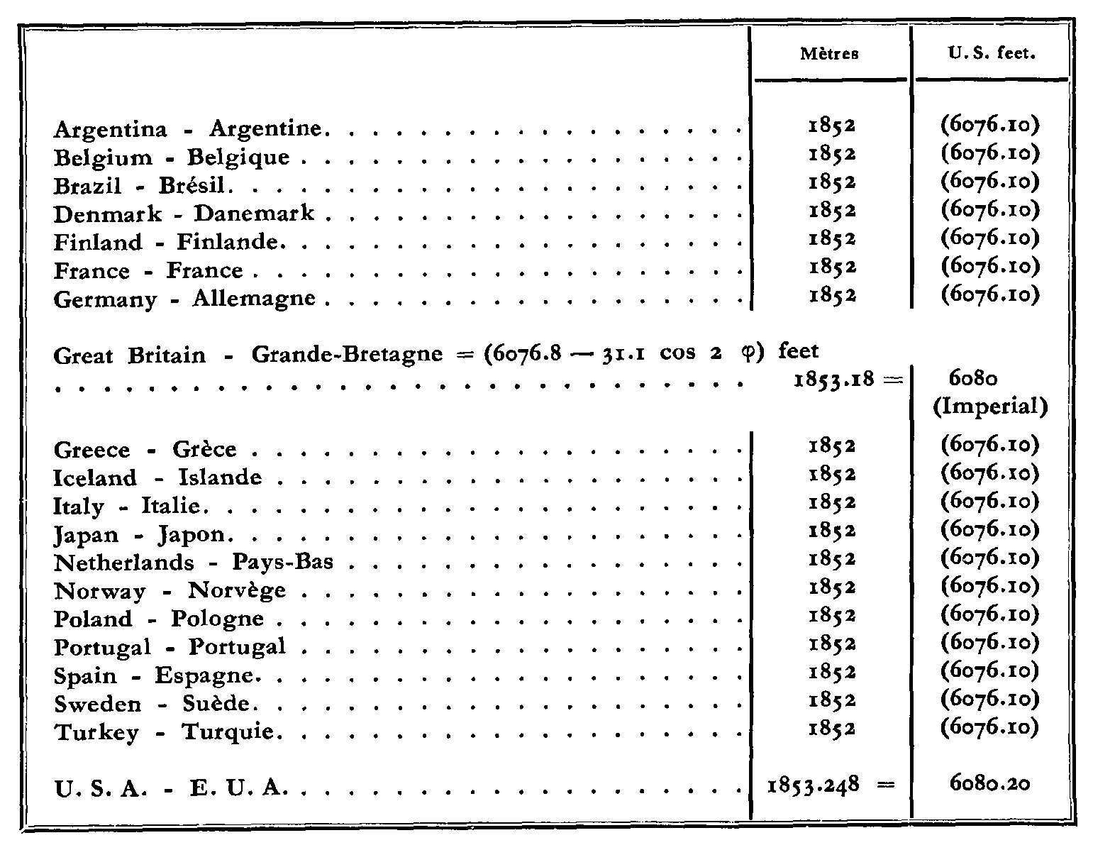
Neither the United States definition nor the U.S. standard length is universally accepted. Some of the values used in various countries are given in Table 3. It will be seen that several countries have adopted the value suggested by the Directing Committee of the International Hydrographic Bureau in 1929.
Because of the disagreement from country to country, it is necessary in scientific work to use a unit universally recognized, or to carefully define the unit used. But to the seaman, the nautical mile is still a minute of latitude, and who can say he is wrong? After all, by the use of this value and skillful navigation he makes his landfalls as anticipated, maintains schedules, and does not “fall in with a place unexpected”.