
Preamble
This manuscript is a reprint of the original paper previously published in 1998 in The International Hydrographic Review (IHR, https://ihr.iho.int/): Mills, G. B. (1998). International hydrographic survey standards. The International Hydrographic Review, 75(2), 97–105. https://journals.lib.unb.ca/index.php/ihr/article/view/22954
1 Background
The International Hydrographic Organization (IHO) traces its origin to the establishment of the International Hydrographic Bureau (IHB) in 1921 which was formed to consider adopting similar methods and procedures in hydrographic data acquisition and nautical chart publication. In September 1970, the Member States formally adopted the IHO name and narrowed the meaning of the IHB to refer only to the Organization’s Headquarters in Monaco. The stated objectives of the IHO include, among others, the coordination of the activities of national Hydrographic Offices and the adoption of reliable and efficient methods of conducting hydrographic surveys. To accomplish these objectives several committees and working groups have been periodically established to draft standards and specifications which are then submitted to the Member States for ratification.
The “IHO Standards for Hydrographic Surveys” are promulgated in Special Publication 44, otherwise referred to as S-44. The first edition of these Standards were published in 1968 with subsequent editions in 1982 and 1987. It should be noted that the IHO Standards are voluntary and are provided as guidance to Member States and others in their conduct of hydrographic surveys. The first three editions of the Standards were philosophically similar in that they applied to surveys conducted for the purpose of compiling nautical charts generally used for marine navigation. Survey scales were specified based on marine traffic usage and water depth and positioning accuracy standards were then based on survey scale due to the practical limitations of draftsmanship.
A Working Group, comprised of experts from 13 Member States, was established in 1993 to review the existing Standards and develop recommendations for changes to S-44 that were relevant to newly developing technology in satellite positioning, wide swath sonar and increased shipboard computer capability. The resulting proposal for the Fourth Edition of the Standards was approved in January 1998 by the IHO Member States and published in April 1998 (IHO, 1998).
As a result of advances in precise positioning from satellite systems (GPS – Global Positioning System and GLONASS) and the ability to accurately plot digital spatial data, S-44 has been modified to utilize real-world metric positioning accuracy standards. Shallow water multibeam echosounder systems and side scan sonars with dramatically increased data density have resulted in changes to the Standards to describe adequate bottom coverage in lieu of specified line spacing based on scale. With the development of Geographic Information Systems (GIS), hydrographic survey data is being used by a much more diverse group than previously. This not only increases the demand for data in digital form but also for metadata about the quality of the data and the methods and procedures used for acquisition and processing. A brief review of measurement errors is needed to understand the meaning of the 95 % confidence levels specified for position and depth accuracies in the new Standards. An error is the difference between a measured value and the correct or true value and can be categorized as a blunder, systematic error or random error. Blunders are generally large errors caused by inattentiveness or lack of skill on the part of the observer. Systematic errors are those that follow some physical law or rule by which they can be predicted. Random errors are generally small errors resulting from the limitations of measuring devices and processes, are equally likely to be negative or positive, and are governed by the laws of probability. Blunders must be eliminated by the establishment of adequate “checking” procedures and are assumed to not be present in quality hydrographic survey data sets. Systematic errors are measured or modeled using calibration techniques and must be removed from survey data prior to evaluating them against the IHO Standards. Random errors result from the inability to perfectly measure any quantity or to perfectly model any systematic error.
In practice, random errors of hydrographic measurements are assumed to be normally distributed (otherwise referred to as a Gaussian distribution). If one were to graph an infinitely large number of normally distributed random errors, the resulting “probability density function” would be a “bell-shaped” curve. The plus/minus distance from the mean that encompasses 68.3 % of the area under the curve is referred to as the standard deviation and symbolized by sigma (σ). The area under the curve between ±2σ from the mean is 95.4 % of the total area under the curve. In the strictest definition, the usage of standard deviation, or probability percentage, in describing the quality of data refers to precision or the repeatability of a measurement. The closeness of the mean of a series of measurements to the true value defines the accuracy.
2 New survey “orders”
The S-44 Working Group proposed a classification scheme for hydrographic surveys based on an area’s importance for the safety of surface navigation. The variation in accuracy standards for each survey “order” reflects this variable importance and effectively replaces the scale-based positioning and data density standards of previous editions of the Standards.
Special Order hydrographic surveys cover areas where ships may need to navigate with minimum underkeel clearance and where the bottom characteristics are potentially hazardous to vessels such as boulders or rock outcroppings. This Order survey requires higher accuracies than those previously specified and for that reason has been particularly controversial. Special Order surveys are only applicable to those areas specifically designated by the Member State’s agency responsible for the survey quality. Inherent in the requirements are closely spaced survey lines with side-scan sonar, multi-transducer arrays or multibeam echo sounder arrays to obtain “100 % bottom search”. This term was adopted after numerous discussions on the impreciseness of the previously proposed term “100 % ensonification”.
Order 1 surveys are intended for harbours and general intercoastal and inland navigation channels including those approaching harbours where vessel drafts have a greater clearance above the seafloor or where the bottom characteristics are less hazardous (e.g. silt or sand) than for Special Order survey areas. The standards for this order are very similar to the general standard of previous editions of S-44.
Order 2 surveys are applicable for those areas with depths less than 200 metres which are not covered by the criteria for Orders 1 or 2. Specifications for Order 3 surveys are applicable in water depths greater than 200 metres.
3 Positioning standards for soundings
The Third Edition of the S-44 IHO Standards specified that soundings should be determined, relative to shore control, such that there is a 95 % probability that the true position lies within a circle of radius 1.5 mm, at the scale of the survey, of the determined position. Therefore, for a 1:10,000-scale survey, soundings were to be located within 15 metres of their true position with a confidence of 95 % probability. In addition to all of the equipment and measurement errors associated with positioning systems, random errors associated with plotting soundings, either manually or by plotter, had to be included. Hence, the allowable error in positioning systems and their measurements in the U.S. were restricted to 1.0 mm at the scale of the survey.
The new Fourth Edition of the Standards specifies varying horizontal accuracy, in metres at the 95 % confidence level, for the four survey orders. One new aspect of the positioning standard is the inclusion of a depth-dependent factor which takes into account the added uncertainty of the positions of soundings from multibeam sonar systems as depth increases:
- 2 metres for Special Order
- 5 metres + 5 % of depth for Order 1
- 20 metres + 5 % of depth for Order 2
- 150 metres + 5 % of depth for Order 3
Because the term accuracy is used in these specifications, it is incumbent on the data acquisition unit to minimize all systematic errors and use appropriate equipment and techniques with sufficiently small random errors.
4 Depth standards
The total error in measuring depths, according to the Third Edition of the IHO Standards, should not exceed, with a probability of 90 %, 0.3 metres for depths less than 30 metres or 1 % of depths greater than 30 metres. This did not include the errors associated with the measurement of tides, determination of a sounding datum and the transfer of the sounding datum from an appropriate tide gauge to the survey area. The combination of such tide-related errors was not to exceed the error allowed for depth measurement.
The Working Group decided during the drafting of the Fourth Edition of the Standards to adopt three major changes regarding depth accuracy in addition to the introduction of the four survey orders:
- the probability or confidence level should be increased from 90 % to 95 % which is a more widely used value for survey measurements.
- depth accuracy standards should allow for fixed errors as well as depth dependent errors and these should vary according to survey order.
- errors due to tidal measurements, datum determination and sounding datum transfer should be included.
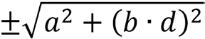
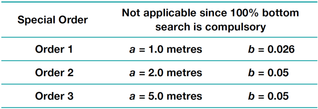
The below listed values a and b should be introduced into the following equation to calculate the error limits for depth accuracy:
| Special Order | a = 0.25 metres | b = 0.0075 |
| Order 1 | a = 0.5 metres | b = 0.013 |
| Order 2 | a = 1.0 metres | b = 0.023 |
| Order 3 | a = 1.0 metres | b = 0.023 |
In the above expressions:
- a is the depth independent error, i.e. the sum of all constant errors
- b is the factor of depth dependent error
- d is the depth
- b·d is the depth dependent error, i.e. sum of all depth dependent errors
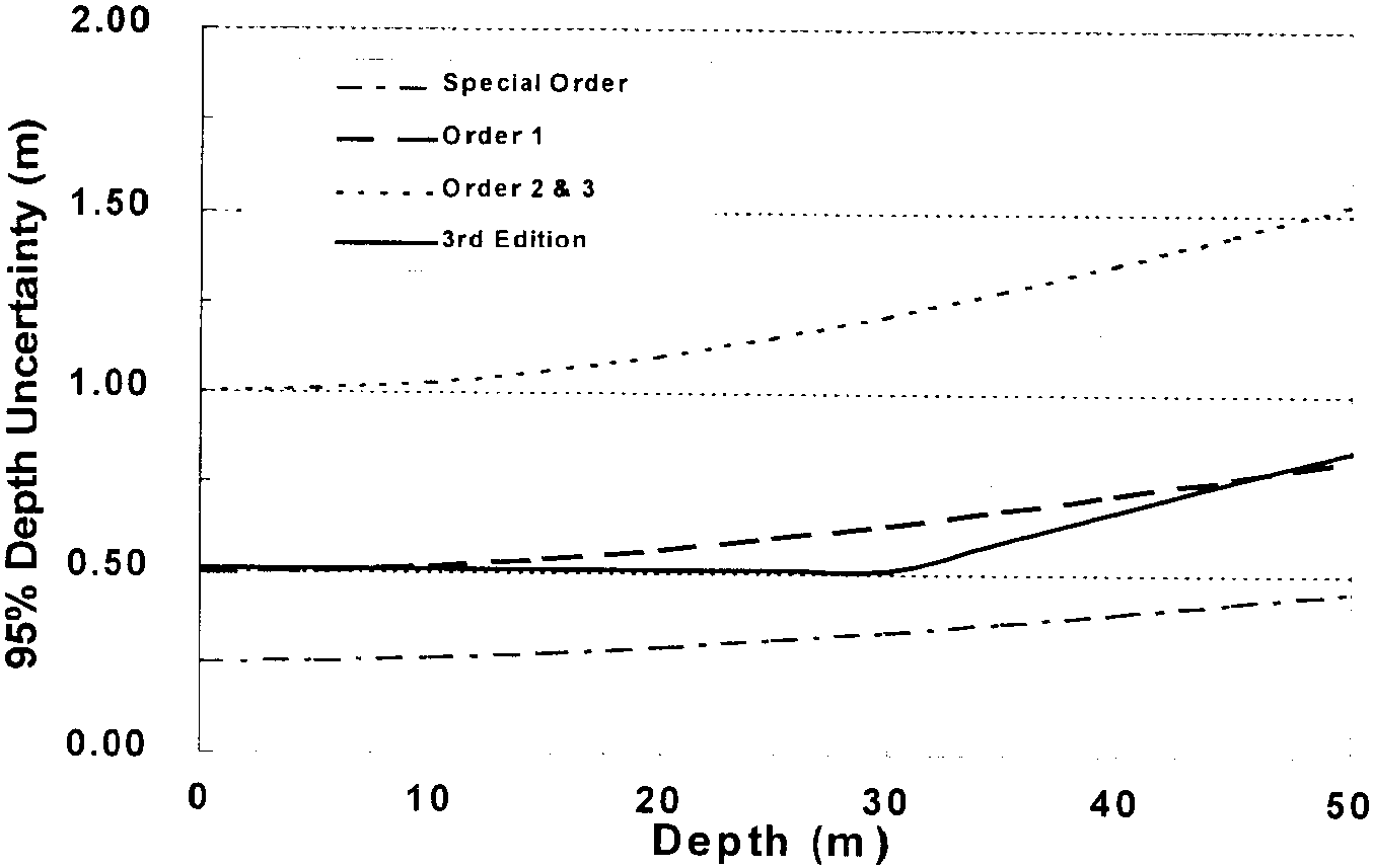
Fig. 1 below compares the depth error limits for the four orders to the comparable allowable error from the Third Edition of the Standards. The latter was obtained by calculating the root-sum-square of the allowable error for depth measurements (0.3 metres for 0 to 30 metres depth, 1 % of depth deeper than 30 metres) plus the allowable error for errors due to tides (also 0.3 metres for 0 to 30 metres depth, 1 % of depth beyond 30 metres) and converting the result from 90 % probability to 95 % probability. By comparing the curve for Order 1 to that of the Third Edition, one can see general agreement between O and 10 metres, a relaxation of the standard for Order 1 between 10 and 45 metres, and a more stringent standard deeper than 45 metres. As most Order 1 surveys will generally be conducted in depths less than 45 metres, this more restrictive standard in deeper water should not be viewed with concern.
5 Data density standards and feature detection
Previous editions of the Standards included recommended sounding line spacing and sounding interval based on the scale of the survey. It was anticipated that these “data density” standards would provide a reasonable probability that features potentially hazardous to navigation would be detected. The Third Edition of the Standards stated that sounding lines should not be more than one centimetre apart at the scale of the survey and the sounding interval should not exceed 4 to 6 centimetres at survey scale except in areas of quite flat or smooth seabed. It was decided that a more “scientific” approach should be taken using increased computer capabilities and/or side scan and multibeam sonar systems.
The Working Group initially considered the use of geostatistics to determine the best estimate of the depth of the seafloor, called a bathymetric model, and an error estimation of that modeled surface using bottom roughness and the proximity of the soundings to one another. The acceptability of the survey data could be judged by comparing the resulting error model to values based on the above equation for depth accuracy where the values for a and b are as follows:
The error model could be used to identify areas of high probability of the occurrence of shoals due to geological processes. Obviously, it could not provide any statistical model for the occurrence of man made features. This latter characteristic plus the lack of widespread familiarity and use of geostatistics rendered it unsuitable as the primary international standard. However, it was retained as an option in a later section of the new Standards.
Eventually a combination of maximum line spacing, sonar system detection capability and the concept of 100 % bottom search were adopted. While the Third Edition of the Standards prescribed line spacing that was dependent on the scale of the survey, the new Standards are generally dependent on the average water depth (Order 1–3 times average depth or 25 metres, whichever is greater; Order 2–3 to 4 times average water depth or 200 metres, whichever is greater; and Order 3–4 times water depth). This line spacing does not apply to Special Order surveys which require 100 % bottom search, a new term that implies a full search of the seafloor has been conducted. Some relaxation in the line spacing standard is permissible if appropriate procedures are adopted to ensure adequate detection of hazards for navigation. Sonar systems used for Special Order surveys must be capable of detecting features greater than 1 metre in size whereas the detection capability of systems for Orders 1 and 2 is for features 2 metres in size in depths up to 40 metres and 10 % of the depth beyond that depth. Some considerations about the feature detectability of side scan sonars and multibeam systems are presented by Clarke (1998).
6 Other items of interest
Under the new Standards, primary shore control points should be located to a relative accuracy of 1:100,000 if ground survey methods are used and errors should not exceed 10 centimetres at the 95 % confidence level when using satellite positioning. Standards for the positioning of navigation aids and other important features have also been modified in accordance with the four orders of hydrographic surveys. Fixed aids should be positioned within 2 metres for Special Order and Order 1 surveys and 5 metres for Orders 2 and 3 whereas the standards for floating aids are 10 metres for Special Order and Order 1 and 20 metres for Orders 2 and 3. The location of other topographical features, including natural coastline, should be located within 10 metres for Special Order surveys and 20 metres for Orders 1, 2 and 3.
A new requirement pertaining to the measurement of tidal heights has been adopted. The total measurement error should not exceed ±5 centimetres at the 95 % confidence level for Special Order surveys and ±10 centimetres for other surveys. These measurement errors plus those introduced from the sounding datum determination process and the transfer of that datum from the tide gauge to the survey area must then be combined with the other depth measurement errors to determine the depth accuracy of soundings. Digital metadata should now be included with all hydrographic surveys to facilitate the usage of the data by an increasingly diverse population of users. Information should be included not only about the survey vessel, area, date and equipment used but also about the calibration procedures, sound velocity determination and tidal reduction methods. Estimates about the data accuracy and associated confidence levels should also be included.
7 Summary
The development of this new edition of the IHO Standards took nearly four years. During that time the Working Group considered a wide range of views from the various Member States, each of which had concerns about the implications of these Standards for not only the profession of hydrography but for their nation.
The effect of this Fourth Edition of the Standards on NOAA hydrographic surveys, both in-house and contracted, has not yet been fully determined. Given that most surveys will fall into the Order 1 category, particular care will be necessary to meet the horizontal accuracy requirements. It is also likely that renewed attention will be given to quantifying the errors associated with tidal height measurements, datum determination and related errors.
References
International Hydrographic Organization (1998). IHO Standards for Hydrographic Surveys. Special Publication No. 44, 4th Edition.
Clarke, J. E. H. (1998). Detecting Small Seabed Targets Using High-Frequency Multibeam Sonar. Sea Technology, 39(6), p. 87–90.