
Abstract
1 Introduction
The IHO Crowdsourced Bathymetry Working Group (CSBWG) was set up by the Inter-Regional Coordination Committee (IRCC) based on Proposal 4 of the Fifth Extraordinary International Hydrographic Conference (EIHC-5) to progress actions on improving the collection, quality, and availability of hydrographic data worldwide. The CSBWG has recently published the guidance document (IHO, 2022). It discusses several areas from data collection to data contribution and is a good baseline when considering CSB. There are however several further issues that need to be carefully considered when looking at the re-survey of the North Sea area.
2 Scope
Crowdsourced bathymetry is the collection and sharing of depth measurements from vessels, using standard navigation instruments, while engaged in routine maritime operations’ (IHO, 2022). This description allows for some considerable difference in quality and extent of provided data but does still not encompass all forms of bathymetric data that might be collected outside of surveys commissioned for SOLAS navigation purposes.
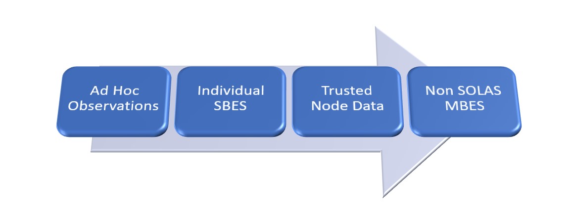
Fig. 1 shows a simple view of different types of bathymetric data that may be received by a Hydrographic Offices (HO). From single data points provided on a Hydrographic Note or email with little or no explanation, through individual lines of SBES, again potentially with little or no metadata to data that has passed through a data aggregation centre where some statistical analysis may have occurred. At the right of the model are comprehensive MBES surveys that for all intents and purpose look identical to a modern SOLAS survey but lack the quality assurance to be consider of the highest standard.
3 Current use of crowdsourced bathymetry
HOs have been utilising bathymetry data provided by external agencies and individuals throughout their histories, with Hydrographic Notes often leading to chart updates and on occasions the commissioning of surveys to confirm clearance in critical areas. Re- cent developments which have led to the publication of IHO (2022), while potentially encompassing the whole gamut of potential data, have more to do with the global scale and international harmonisation of the central two element of CSB (Fig. 1).
(IHO 2022) and this paper concentrate on acoustic data sources collected by ships of opportunity. Other methods of bathymetric collection such as lidar, satellite derived and photogrammetric methods are less common, and are not generally collected during routine maritime operations so are not discussed further.
4 Considerations in planning a resurvey scheme
There are several considerations that define the risk associated with navigating over a given portion of sea and as such the risk of any an incident occurring that could lead to injury, damage to the environment, or to a negative economic outcome are also very different depending on the area. The main considerations, discussed below, should be considered when planning any (re)survey campaign in order to best reduce the risk to maritime users, and optimise the surveying effort to areas of potential change.
4.1 Nature of the seabed
The nature of the seabed is not the same throughout the area of interest. Different depths and geology of the seabed are all shaped by different oceanographic conditions. As such different policies and strategies are required to ensure optimum coverage of those areas of seabed that are most likely to change rapidly over time. Much of the North Sea area is made up of very mobile seabed sediments, with large dunes and wave structures that move seasonally (shifting in the direction of the residual current over longer time periods).
4.2 Maritime usage
The usage of an area of sea also varies considerably from almost zero in some areas of deep ocean, to areas heavily used for shipping, offshore energy and aquaculture. The North Sea area is one of the most heavily used maritime areas in the world, with much of the area considered critical1 to shipping.
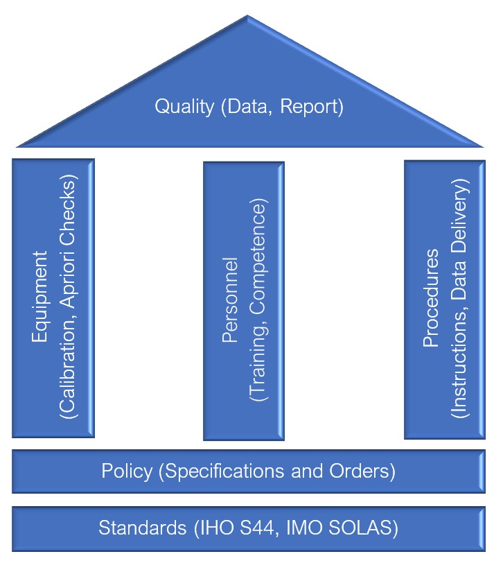
4.3 Accuracy of soundings
There are five key factors that control the overall quality management of the survey data that forms the basis of any chart whether paper or electronic. These are portrayed in the ‘quality house’ at Fig. 2.
The IHO has, since its inception in 1921, worked to ensure that the world’s seas, oceans and navigable waters are surveyed and charted, through several publications including (IHO, 2008). The IHO has laid out the requirements for both surveying and charting to ensure this has been done to an accuracy that does not compromise safety of life at sea. These standards underpin the survey work conducted by or on behalf of HOs.
Compliance to these standards is assured by the HOs by ensuring the standards are fully adhered to by the production of specifications (technical instructions) and ensuring the right personnel, equipment and procedures are used. For example, since the late 1990’s most surveys in safety critical areas of the North Sea (less than 40 m) have been done with Multi-Beam Echo Sounders with respect to Order 1A survey standards or higher to enable A1 Category Zones of Confidence (CATZOCs) to be allocated during data validation and onward charting.
4.4 Age of survey data
Alongside elements related to the accuracy and spatial resolution of the survey data, the age of the survey data can be an important quality factor. Depending on the seabed mobility mentioned above, a survey conducted relatively recently may be considerably in error in some areas but valid in others. The IHO S101 ENC standard now enshrines the importance of this temporal nature of the seabed in its potential new mandatory attribute ‘category of temporal variation’ (COTV)2.
5 Potential use of crowdsourced bathymetry
There are two main potential uses of CSB in the North Sea Area: charting and monitoring.
5.1 Charting
The consensus of the RWG is that CSB is not normally suitable for charting in many areas of the NSHC area, as the risks associated with navigating with critical depth data that has not been collected and assessed using comprehensive quality assurance and control methods will often outweigh any benefits of newer data.
The coastal states of the NSHC all have “first class” hydrographic services capable of carrying out bathy- metric surveys necessary to ensure the safety of navigation in the region. Considering the importance of the maritime traffic in the North Sea Area, one of the largest in the world, the number of nautical incidents related to lack of knowledge of bathymetry is insignificant.
In this region, the primary interest of the CSB does not therefore lie in the knowledge of bathymetry for charting purposes but rather in assisting in the planning of surveys using the CSB as a tool for detecting discrepancies with the chart in use and/or monitoring changes.
A SHOM trial using OLEX data noted that such da- ta may not be suitable for charting in safety critical depths (< 40 m) but can potentially be used to fill in gaps in data in deeper waters.
5.2 Monitoring
By regular monitoring of mobile seabed features, their movement and growth can be better modelled to allow survey effort to be better prioritised in critical areas. There are however several issues. Some Hydrographic Offices now analyse dune dynamics using MBES data. MBES data gives a full and detailed understanding of the dune morphology (especially in 3D) and thus allows the dune dynamics between each successive survey to be estimated with precision. CSB being made up predominantly of SBES data (2D) proves less useful for dunes with slow dynamics unless the profile is perpendicular to the dune as any calculations are less accurate due to the difficulty in assessing the main displacement direction of the dune.
SHOM abandoned the comparison between the “old data” acquired with SBES and the more recent MBES data because the simple rotation of the dune crest was sufficient to significantly bias the calculations of dune movement velocities.
Even in the case of very dynamic dunes, the dis- placement velocities remain quite slow (generally not exceeding 50 m / year). In the case of recurrent high frequency bathymetric profiles acquired by SBES, the measurement uncertainties inherent in the CSB could thus be of an order of magnitude equivalent to the observed displacements, uncertainties further aggravated by the combination of dune displacement and rotation that cannot be disassociated in the SBES data.
These difficulties in exploiting SBES data from the CSB should not be underestimated.
Although intuitively appealing as a tool for change analysis, the operational reliability of the CSB should be studied in detail to support the definition of survey strategies to address critical navigation safety issues. While the CSB may be of interest for monitoring the dynamics of highly mobile areas, the possibility of exploiting these punctual (SBES) opportunity data to study with sufficient precision and reliability the complex dynamics of dunes (combination of displacements and deformations) remains to be demonstrated.
6 Benefits of crowdsourced bathymetry
While the benefits of CSB have been widely ex- claimed, it is worth pointing out the key factors that have led to such emphasis being placed upon it by the IHO and others.
6.1 Repetitive Measurements
While individual measurements may not prove to be accurate, CSB has the potential to allow seabed mobility to be monitored. A vessel or groups of vessels passing over the same ground regularly, provide an ideal opportunity to conduct empirical studies and in- form future resurvey activity and marine activity.
6.2 Cost (currency and environmental)
The use of CSB data, collected by vessels regularly transiting the area along recurrent routes, as a tool for monitoring seabed dynamics should make it possible to define resurvey strategies more effectively, by concentrating recurrent survey efforts on areas where sediment dynamics require repetitive, high-frequency surveys, and by limiting resurvey effort in areas where CSB demonstrates sufficient seabed stability.
6.3 Economic
The Blue Economy is worth substantial amounts of money every year. Any information that potentially opens sea areas to more/larger vessels could result in noticeable increases in revenue for a country. CSB by utilising large numbers of different classes and sizes of vessels has the potential to notify HOs and mariners directly of changes to depths or new passage routes that could allow deeper draught vessels to enter a port or save time on transit.
7 Issues with crowdsourced bathymetry
7.1 Quality of data
Chapter 2 of (IHO, 2022) discusses several technical issues, such as sensor offsets, draught measurements and timing issues. These are a non-exhaustive list of all areas that a professional surveyor will both be checking and reporting on during a survey. IHO (2008) states in its introduction that ‘The surveyor is an essential component of the survey process and must possess sufficient knowledge and experience to be able to operate the system to the required standard’.
CSB by its very nature does not get conducted by a qualified and knowledgeable surveyor using specially calibrated equipment. As a result, the quality and hence the standard of the data received is difficult to assess. Such poorly quantified data can cause considerable issues for charting. If a shoal depth is received, it either must be charted, potentially closing shipping routes or ports, or investigated at expense to the resurvey programme.
The vast majority of all current CSB is reliant on Single Beam Echo Sounders, not fully calibrated and not fully adjusted for the technical issues noted above. As such it does not achieve any survey standard in (IHO, 2022) and if charted would generally be categorised as CATZOC D (which itself is just an indication that the data does not achieve CATZOC C) when translated into charting quality terms.
In addition to the measurement errors inherent in CSB, the complex geometry of dunes makes it critical to quantify the dynamics in order to adopt appropriate survey strategies for safety issues.
The current methods of exploiting SBES data do not indeed allow to dissociate dune displacements from their deformations. The study of the contribution of CSB as a monitoring tool will therefore have to question the methods of exploitation of CSB SBES data to obtain robust estimates of displacements.
7.2 Resource
Resource requirements to look at ever increasing amount and size of bathymetric datasets are not in- significant even for nations with relatively small sea areas. Add to official surveys, the requirement to re- solve CSB quality issues and it is unsurprising that most HO do not currently actively seek out CSB.
7.3 Liability
Hydrographic Offices have a requirement to ensure that the data they use for charting has as a minimum been assessed in terms of accuracy, so a descriptor can be applied to it for the mariner to make suitable navigational decisions. This is in the form of a source data diagram for SNCs and Category Zones of Confidence (CATZOCs) for ENCs. There is some concern that if large amounts of CSB are available relatively easily, it will become a de facto requirement for all HOs to constantly check holdings prior to the production of new charts.
There are several examples of HO being taken to court including the grounding of the QE2 off Martha’s Vineyard in 1992 (Lusk, 2009) and the more recent case in 2010 of the Clipper Adventurer running aground on an uncharted shoal in the Canadian Arctic. While in both cases the HO responsible were exonerated despite shortcomings in procedures, there is concern that litigation might increase if incidents are potentially caused by inaccurate data being charted as opposed to survey data not being gathered or charted at all.
Looking at the other perspective of legal action ensuing from the non-charting of data that was available in CSB holdings, HO could be forced to assess all available data of whatever source and quality. This would be resource and time heavy and potentially lead to the unsafe situation where charts updated with full modern SOLAS data are delayed while sifting through large quantities of lesser quality data.
7.4 Awareness of Quality by Mariners
There is some concern that the knowledge of many mariners regarding the differing quality of data on both SNC and ENCs is less than ideal. By populating a chart with poor quality data, no matter the attached quality metadata, the HOs is potentially inviting such a mariner to navigate poorly surveyed waters. By not attempting to fill in gaps with poor quality data, it is obvious to all that navigation through such an area should not be attempted.
8 CSB datasets
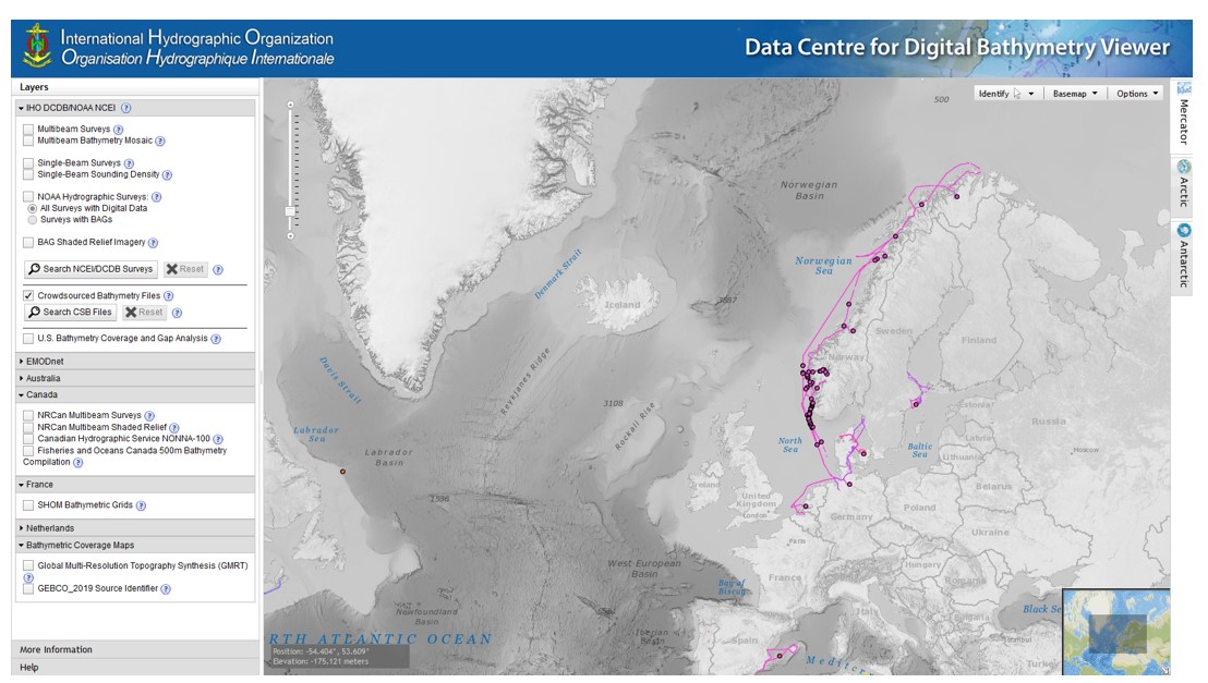
There are several datasets of crowdsourced bathymetry that already exist. Some are referenced in the IHO’s own Data Centre for Digital Bathymetry (DCDB). The screenshot in Fig. 3 shows the current CSB coverage in the North Sea area referenced in the DCDB
To date, few CSB datasets are thus present in the DCDB. Other more commercial databases exist such as OLEX, that operate under different business models. OLEX allows for subscribers to share CSB data collected using the OLEX hard and software. An offline license is available, but this does not allow the data to be used for charting.
The collection of this bathymetric data of opportunity is a real challenge, as few datasets arrive spontaneously to hydrographic offices or services.
9 Current work
There are several national trials already underway in the North Sea Region to assess the accuracy and potential use of CSB in the region.
The UK Hydrographic Office is also currently working on a data triage process to better prioritise data based on several factors (area of responsibility, cur- rent CATZOC and depth) to attempt to be able to better prioritise increasing and more varied data volumes. These are by no means exhaustive and as the process matures, factors such as quality and ease of validation of incoming data will also be investigated.
This requirement to triage the increasing amount of potential data that could be utilised by HOs fits in well with risk mapping where it could be envisaged that an evaluation of likelihood of accuracy of CSB based on underlying data.
10 Intelligent crowdsourcing
As opposed to simply taking in all available bathymetric data, HOs could look to control the data using three main approaches. Firstly, instead of accepting all and any crowdsourced bathymetry for charting, a HO could seek out data for specific areas, either before compilation of new chart, where gaps or old data exist, or for use in locating areas of change from historic data to inform survey planning.
Secondly, data from more accurate systems, for example on scientific cruises, could be utilised. This may take the form of additional processing to take account of such things as sound velocity, and data cleaning. In many cases, such data may come from MBES and be supplied with a report on procedures used when collecting the data. With the additional work outlined such data may be capable of achieving a CATZOC B. While not ideal, this is still some way better than the CATZOC D allocated to the majority of CSB.
Thirdly, an individual or group of HOs might work more closely with a specific shipping company to provide more targeted data. By working in partner- ship with a regular service that crosses an area of interest, such as a ferry operator, potentially useful information could be gathered. Initially this could be utilising equipment already onboard (navigational SBES and standard GPS), which while not achieving the sort of accuracies desired for charting would provide an estimate of seabed mobility. Since most current CSB data comes from single-beam echo-sounders, the reliability of this estimate would need to be evaluated and new methods for exploiting the data developed in order to have sufficiently reliable and robust estimates of the complex dynamics (combination of displacements and deformations) characterising the dunes.
This would allow improved planning for future re-survey activity. Potentially this could, if proven useful, be improved by the provision of MBES that could at least be partially calibrated (sound velocity probe at the MBES head) and then onward processed and checked at the HO to allow more accurate data to be collected either for charting or monitoring. These MBES datasets would allow for a more detailed study of the complexities of dune dynamics and easier comparison with the HO datasets which are almost exclusively acquired using MBES. This approach is however not without difficulties. There would be a requirement for regular visits to the vessels to download data or even to operate the equipment on an agreed interval as opposed to running the equipment when- ever the vessel sails. This would require funding and resourcing as well as agreement across nation states to agree on data collection, processing and sharing. Such agreement would be non-trivial to manage, with many nations’ regulations on CSB already not necessarily convergent as proven by the answers provided to the IHO Circular Letter 11/2019 calling for approval of the Edition 2 of the B-12 CSB Guidance Document as published at (IHO, 2019).
11 Way ahead
This paper does not provide a blueprint for the full in- corporation of Crowdsource Bathymetry into the charting flowline but rather outlines the issues and concerns from a technical level as well as the potential consequences and issues that are being considered.
While its shortfalls are well understood within the survey community, there is a global push to utilise CSB data to fill in the gaps of more traditional survey capture techniques.
It is recommended that individual Hydrographic Offices consider further exploring the possibilities of CSB, both in terms of increased accuracy for charting and with regards to seabed monitoring to ensure limited survey resource is best deployed. Any cross-boundary work should be looked upon positively by the respective countries.
It is further recommended that the legal consequences of using and not using CSB are fully investigated at an international level, to provide further guidance on its incorporation into charts.
Acknowledgements
Phil Payne as the Chair of the NSHC RWG brought together the thinking of the following member states to author this paper on their behalf: Belgium (Johan Verstraeten), Germany (Bernd Vahrenkamp), Denmark (Lars Hansen), France (Vincent Lamarre, Thierry Schmitt), Netherlands (John Loog) and UK (David Parker, Andrew Colenutt).
References
IHO (2008). IHO Standards for Hydrographic Surveys. IHO Special publication 44, Edition 5. International Hydrographic Organiza- tion, Monaco.
IHO (2019). Acceptance of crowdsourced bathymetry activities in national waters of jurisdiction. IHO Circular Letter 47/2019. https://iho.int/uploads/user/circular_letters/eng_2019/CL47_ EN_2019_v1.pdf (accessed 11 Sep. 2023)
IHO (2022). Guidance on Crowdsourced Bathymetry. IHO publication B-12, Edition 3.0.0. International Hydrographic Organization, Monaco.
Lusk, B. (2009). Grounding of the Queen Elizabeth 2 – The Consequences of Neglecting Hydrographic Standards. Hydro Inter- national, 13(6).