

The United States and Canada have a long history of collaboration when managing maritime charting items. For decades, the two nations have had formal hydrographic survey and charting collaborative programs. Working together allowed in-depth discussions about similar challenges and supported innovative ideas. It has allowed these two countries to become strong supportive members of the International Hydrographic Organization (IHO).
As shipbuilding, surveying, and navigation technology advanced into the twentieth century, the need for bi-national work only heightened. The construction of the St. Lawrence Seaway in the area of the Great Lakes and St. Lawrence River waterway led to many notable collaborative efforts, including the establishment of a primary first-order horizontal ground control, an internationally agreed upon vertical control datum, methods to regulate and monitor the hydraulics of the waterway, and the construction of navigational charts before the opening of the seaway.
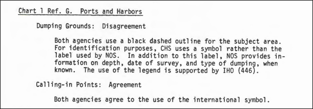
On October 15, 1963, the Dominion Hydrographer (now called the Hydrographer General of Canada) of the Canadian Hydrographic Service (CHS) and the District Engineer of the U.S. Lake Survey (USLS) established the United States Lake Survey and CHS Charting Advisors. (When the National Oceanic and Atmospheric Administration (NOAA) was established in 1970, the Lake Survey became part of NOAA’s National Ocean Service (NOS)). This group was assigned “to review the differing techniques, procedures, and presentation used by the two agencies, and to make recommendations… on the best way to achieve compatibility”. Historical records indicate the group met on a biannual schedule to discuss topics of interest. Some significant contributions of the committee included publishing a report detailing the differences between CHS and NOS charts and a similar document identifying each agency’s pricing and distribution policies (Fig. 1). Additional topics included developing a “comprehensive chart scheme satisfying both U.S. and Canadian requirements” (Monteith et al., 1978).
The group’s research intended to determine the feasibility of constructing a small-scale chart of the Great Lakes according to “bilaterally coordinated standards and published in a single format with both agencies named as originators”. Unfortunately, at the time, it was deemed “impossible in the foreseeable future”.
Despite their inability to create a shared agency chart product, the collaborative work between the two nations proved that bi-national cooperation was worthwhile. In April 1977, the United States-Canada Hydrographic Commission (USCHC) was established by the IHO within the Regional Hydrographic Commissions structure.
The USCHC’s Chart Advisors Committee (CAC) continued to meet periodically to discuss transboundary charting issues until the early 2000s, when the importance of their work was renewed with the introduction of electronic navigational charts (ENCs). In March 2007, USCHC agreed to eliminate overlapping ENC coverage in accordance with the IHO Principles of the Worldwide ENC Database (WEND), which prohibits overlapping ENC coverage from multiple producing agencies.
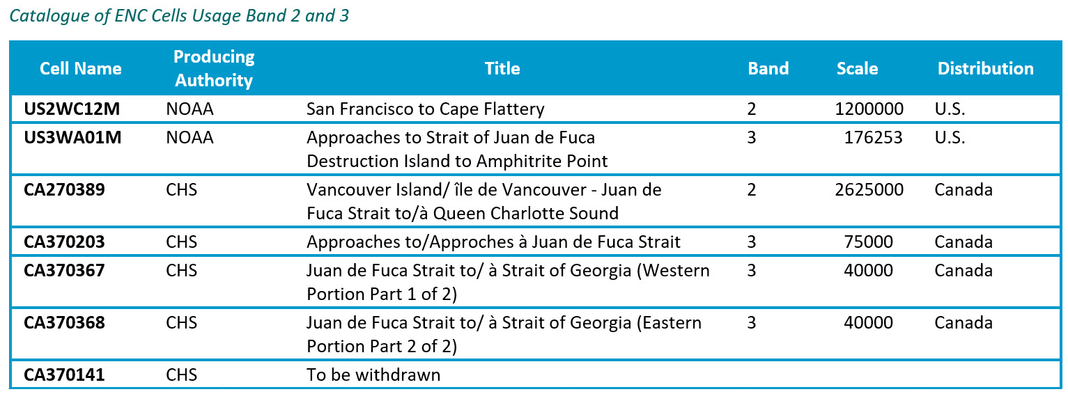
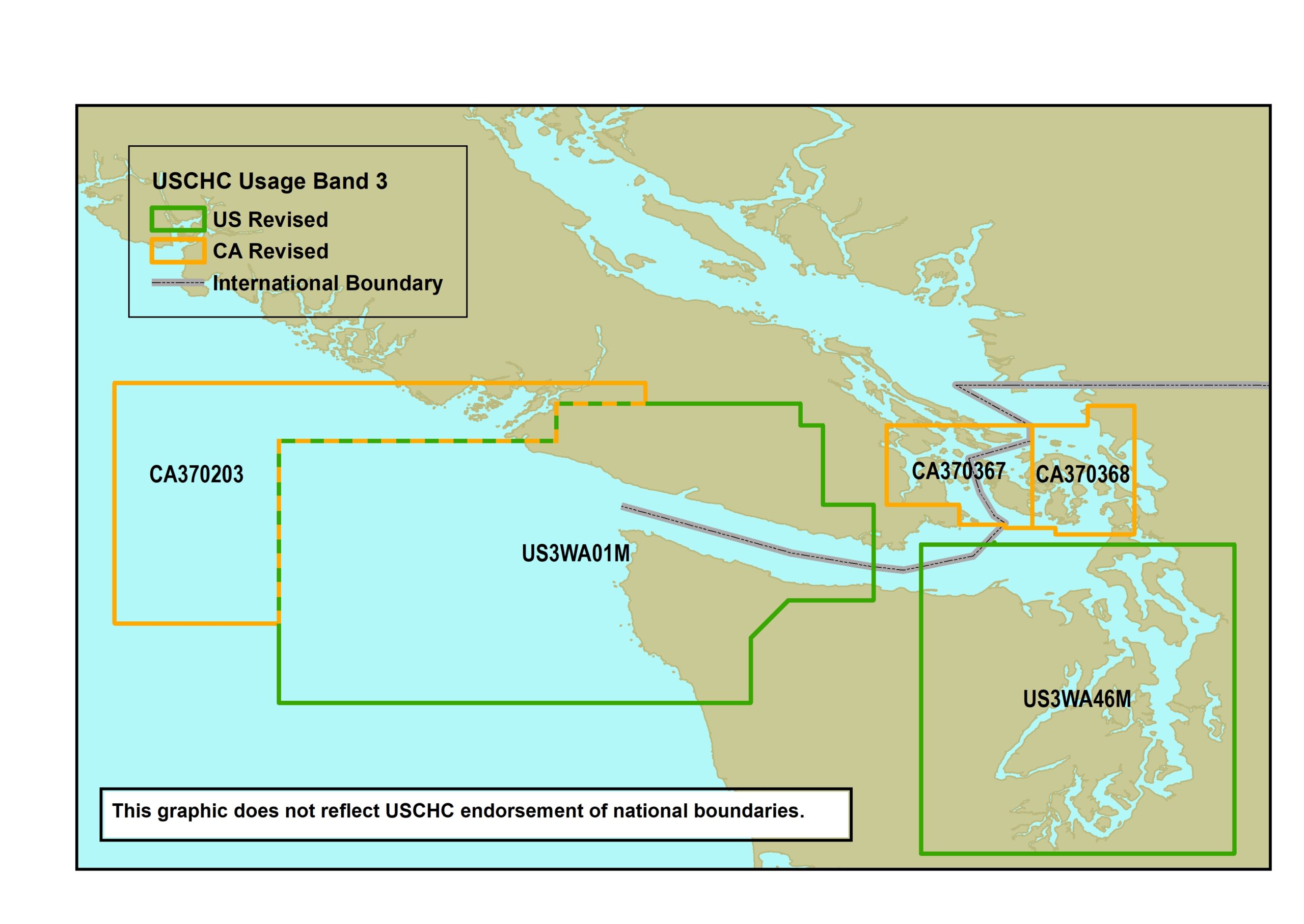
In 2011 and 2012, representatives from the two nations drafted several addendums to the overarching Memorandum of Agreement (MOA; Fig. 2), one for each transboundary region, documenting which ENCs would be cut and which country would be responsible for maintaining them. The existing and proposed new coverage in each region was described in detail, broken down by usage band. Each annex comprised a series of maps supplemented by product metadata that included cell name, producing authority, title, usage band, and scale (Fig. 3).
There were some limitations to documenting decisions this way. It became very complex and difficult to show the decisions clearly. Through excellent collaboration and frequent meetings, the United States and Canada could work through all of their transboundary areas and make decisions on coverage. The maintenance of this work required continual collaboration and information sharing.
In 2018, the CAC was rebranded as the Hydrographic Geospatial Products and Services Committee (HGPSC); however, the work remained the same. In 2021, the United States and Canada started working through re-negotiations of transboundary areas because each hydrographic office was working towards rescheming their ENC coverage into a fixed grid of rectangular cells to support S-100 products. Again, these two hydrographic offices worked collaboratively, meeting monthly or more frequently to discuss specific transboundary areas. Each hydrographic office has a national representative who meets with regional offices during their bi-national meetings. This ensures there is consistency in the strategies used.
Three main strategies have been utilized so far:
- Each nation will maintain rectangular cells along the international border and encode the category of coverage (CATCOV) as CATCOV = 1 (coverage available) within the responsible nation and CATCOV = 2 (no coverage available) on the opposite side of the border;
- The decision for single-agency charting, where one nation will assume responsibility for full coverage of a narrow or complex waterway. We will provide examples and explain where each strategy was applied;
- Single-case, hybrid decisions in areas where the coverage transitions from a CATCOV solution to a single-agency solution or disputed areas.
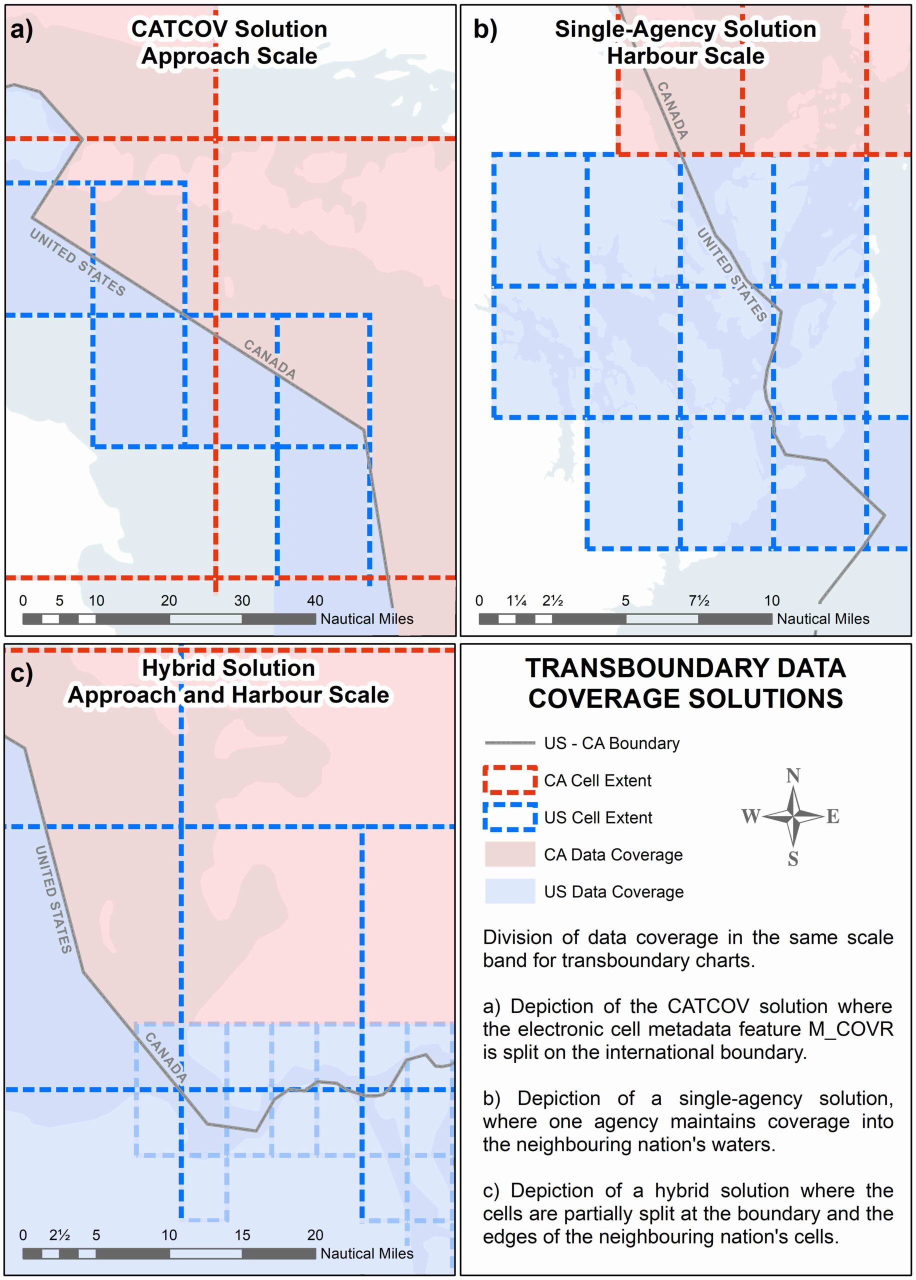
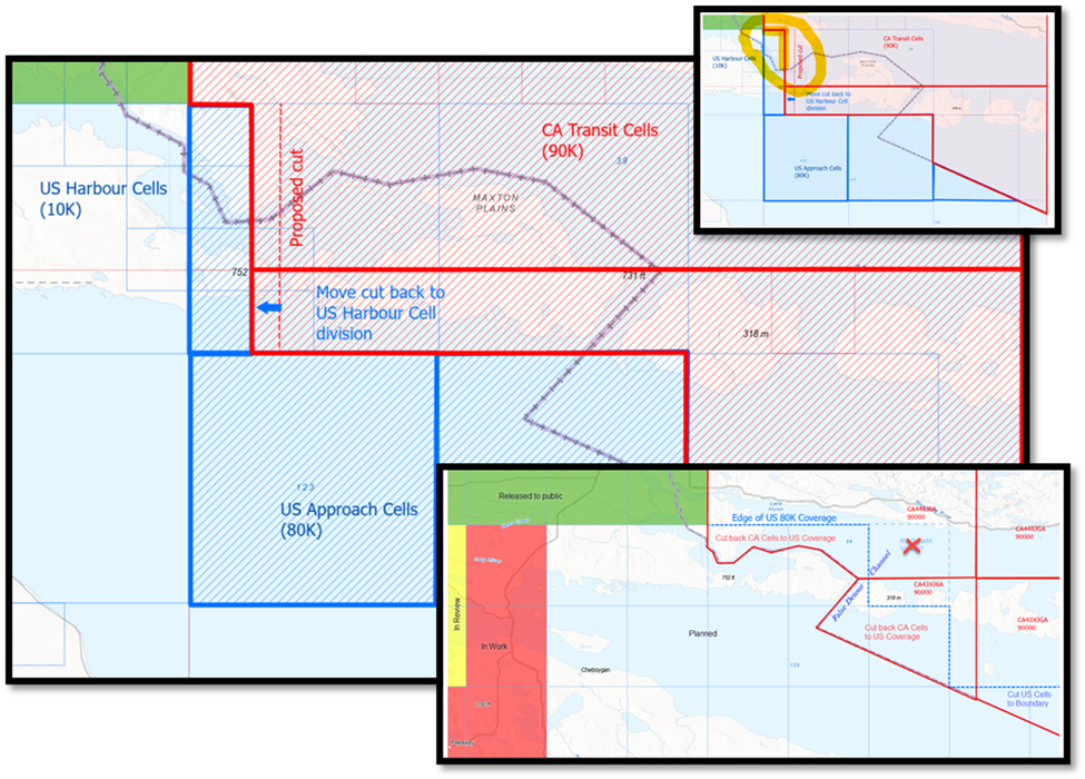
The first strategy splits each nation’s transboundary cell’s CATCOV into “coverage available” and “no coverage available” along the international boundary. The area encoded as “no coverage available” preserves the rectangular shape of the cell but is devoid of chart data. This eliminates the need to maintain detail outside each nation’s borders. This logic was used when CHS released a series of cells in western Lake Huron. The Canadian charting authority cut their cells along the boundary before release to prevent the Approach usage band cells from overlapping (Fig. 4a).
In some situations, splitting the cell at the boundary reduces the usefulness of the data. A single-agency solution is employed in areas where the waterway is narrow or where navigational fairways are aligned to the boundary so that their clarity would be compromised if they were cut. This method allows uninterrupted, unilateral coverage, typically in the largest scale products in a waterway, but could also be employed on smaller scale cells if necessary. The complexity of the Bay of Fundy, on the northeast Atlantic coast, necessitated a single producer for the largest scale charts in the area (Fig. 4b).
A hybrid, single-case approach is used in areas transitioning from a CATCOV to a single-agency solution. The cell cuts will typically follow the international boundary and turn to follow the edge of one of the nation’s cells (Fig. 4c). In areas where the official international boundary between the United States and Canada is disputed, a similar hybrid solution is used. The splits between cells follow the recognized boundary but deviate to cell edges when they approach contested areas, often referred to as grey zones.
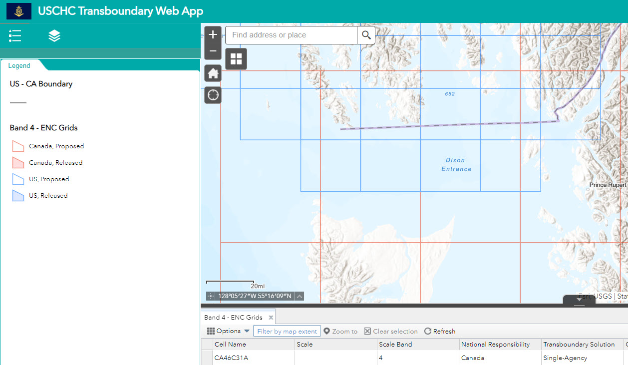
As decisions are made, instead of recreating new static maps, tables, and textural descriptions, US- CHC has allowed for the use of a webmap to document decisions (Fig. 5). This allows for easier analysis, visualization, decision-making, and documentation. It shows existing ENC coverage, the planned and existing grids for each country, and metadata against each cell to show decisions made. The site also allows the addition of links to the decision documents relating to each transboundary ENC.
HGPSC coordinates meetings with regional production branches for each charting agency. As chart rescheming projects accelerated, these meetings increased from a biannual schedule to monthly meetings. Currently, the NOAA (or NOS) Great Lakes production branch and the CHS Ontario, Prairie, and Arctic Region teams meet monthly, and the MCD Atlantic Coast production branch and the CHS Atlantic Region team meet on an ad hoc basis, usually once every two months or more if necessary. As of this date, regular meetings for the Pacific Coast and Alaska are still in the planning stage.
As each regional group builds out its S-100 grid, some situations require each nation to collaborate on the most beneficial solution for the mariner. To help facilitate the flow of information, NOAA has set up a shared space on Google Drive accessible to US and Canadian personnel. This environment provides living documents that can be revised in real-time (Fig. 6).
The transboundary project has become a large, multi-year endeavour, allowing the United States and Canada to reconnect and rebuild working relationships. It has allowed for seamless information sharing and increased collaboration on additional projects. It has engaged staff at the manager, supervisor, and working levels to allow for a more integrated approach to hydrographic and cartographic work. The time and effort spent building this network has been worth the effort. It is now a natural thing to reach out to the other hydrographic offices to discuss challenges and work through solutions together.
References
Monteith, W. J., Kerr, A. J. and Pittman, A. (1978). History of the Great Lakes Charting Advisers (Cooperative Charting by Canada and the United States). International Hydrographic Review, LV(1), 145–158.
USCHC (2023). USCHC Transboundary Web App. United States – Canada Hydrographic Commission (USCHC) Hydrographic Geospatial Products and Services Committee (HGPSC). https://noaa.maps.arcgis.com/apps/webappviewer/index.html?id=3d56cca277334bb18d918e4292bd3313 (accessed 17 Sep. 2023).