


Abstract
1 Introduction
Electronic Chart Display & Information System (ECDIS) is a navigation equipment that displays chart information and surrounding information like depth area, aids to navigation, obstruction and coastline on a computer instead of paper charts used on ships. As a ship operating system, an ECDIS must meet international standards developed by the International Maritime Organization (IMO) and International Hydrographic Organization (IHO) to enhance navigation safety and operational efficiency. As a maritime geographic data system, an ECDIS equipped with up-to-date enhanced navigational charts (ENCs) is important component of electronic navigation equipment and ship operational information that provides waterway data to support navigators during voyage planning, route monitoring, and real-time operational monitoring.
The IMO has mandated the installation of ECDIS for safe navigation. An ECDIS system must contain hydrographic data regarding coastlines, bathymetry, obstructions, and navigational aids. The information is produced in accordance with the S-57 standard published by the IHO, which describes an internationally accepted data structure (Kim et al., 2018). However, there are limitations to the representation of hydrographic data. Considering the limitations of the S-57, the IHO developed a new standard using the S-100, rather than updating the S-57 (Choi et al., 2021).
After the introduction of the new standard, Park et al. (2010) conducted a study to determine a potential plan for an integrated electronic chart supply service system to improve ECDIS functions. To improve the visual elements of the ECDIS, Kim et al. (2020) studied the symbols for maritime safety information that should be displayed on ships’ electronic charts. In terms of navigational safety and efficiency, suggested improvements in ECDIS functions were evaluated by comparing the voyage planning process using paper charts and ECDIS. The results showed that, in terms of functional satisfaction, more than half of the users were generally satisfied with ECDIS.
The S-57 standard-based ECDIS cannot display electronic representations of various types of hydrographic information, such as three-dimensional information or subsea topography and is strictly forbidden via S-52. Tide data are reflected in the voyage plan through navigation information (Ko et al., 2011). However, progress in ECDIS research has led to the development of systems that can meet the needs for maritime information. The S-100 standard provides guidance for establishment of data product specifications; its development is expected to accommodate requirements for the production, analysis, processing, and expression of hydrographic data (Oh et al., 2017). When the S-100 standard is applied to next-generation ECDIS, the information and functions provided by the existing ECDIS (based on the S-57 standard) will change, presumably leading to changes in ECDIS-user interactions and task performance.
Here, to evaluate the effectiveness of the S-100 ECDIS, capable of ENDS, this study analyzed the effectiveness of visual characteristics on voyage planning tasks performed by ship officers.
2 Test set-up
2.1 Participants
Ten people (eight men and two women) participated in this experiment. Six were in their 20s and four were in their 30s; the mean participant age was 30 years. All participants were officers with more than three years of experience on ships.
2.2 Testing equipment
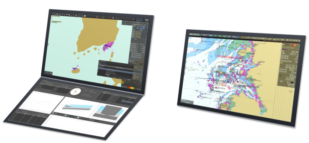
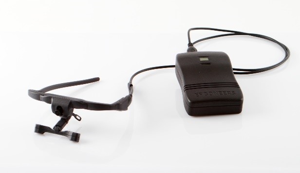
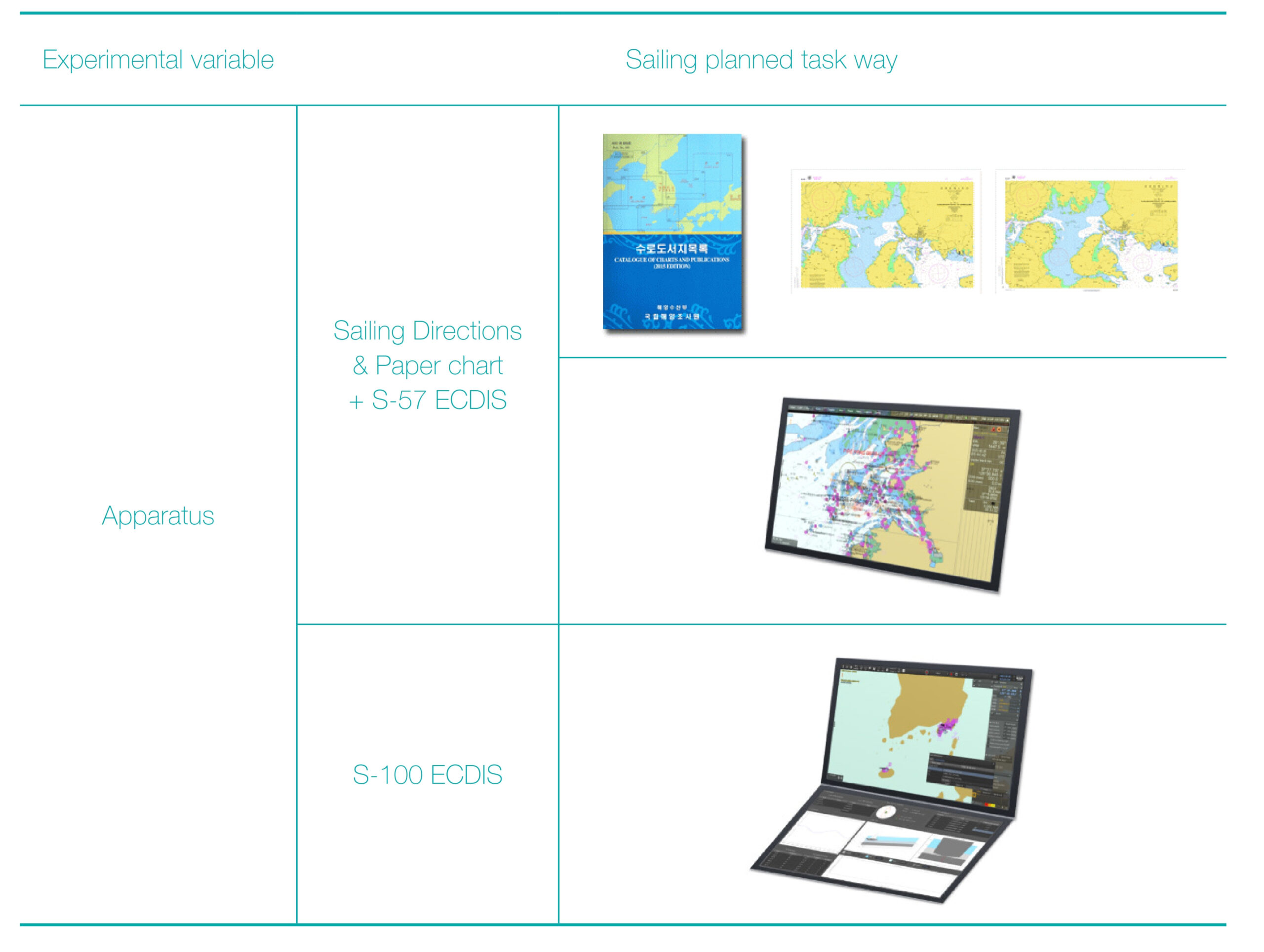
In this study, the equipment to be evaluated comprised two ECDIS (Fig. 1): one was equipped with the S-57 ENC and the other was equipped with the S-100 ENDS. The S-57 ECDIS uses one monitor, whereas the newer S-100 ECDIS uses two monitors. The participants wore an Ergones DG3 Dikablis Glasses 3 eye-tracker while performing their tasks (Fig. 2). The eye-tracker consists of a head unit and an eBox (data box). The field camera speed was 30 Hz, the eye camera tracking speed was 60 Hz for each eye, and the accuracies of pupil and gaze tracking were 0.05° and 0.1–0.3° of gaze angle, respectively.
2.3 Tasks
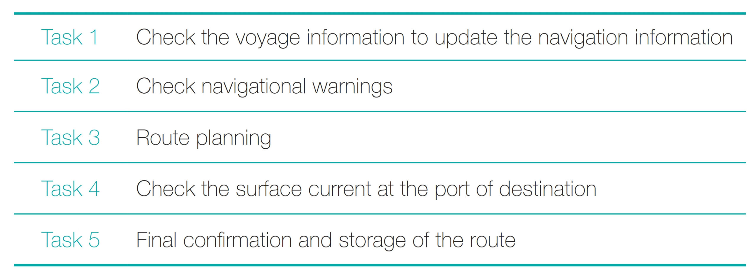
To determine whether the task scenarios used in this study were the same processes used for actual voyage planning, the bridge procedures guideline of ICS (International Chamber of Shipping) that ship officers use for voyage planning were analyzed, and voyage planning cases were investigated. Ultimately, five task scenarios were derived (Table 1).
Task 1 involved ensuring that the voyage plan used the latest navigation information. When using the S-57 ECDIS, participants checked navigation information in the navigation guide. When using the S-100 ECDIS, participants updated the S-123 and S-127 data by application to the S-100 ECDIS. S-123 (Marine radio services product specification) datasets describe the means to capture availability and reliability of radio stations, radio position fixing systems, radio beacons, services offering navigational warnings and weather forecasts in the maritime domain. S-127 (Marine Traffic Management) datasets describe the availability and reliability of vessel traffic services, pilotage, routing measures, and ship reporting systems including their service areas, services offered and instructions for contacting or utilizing these services.
Task 2 involved checking navigational warnings applicable near the departure and arrival ports and ensuring they were present in the navigation system to allow consideration in the voyage plan. When using the S-57 ECDIS, participants checked navigation alerts and marked navigation warnings on the ECDIS. When using the S-100 ECDIS, participants applied S-124 navigation warning data to the S-100 ECDIS and checked the displayed material.
The voyage planning in Task 3 involved establishing the ship type and safe water depth, and then determining whether the planned route is appropriate. When using the S-57 ECDIS, participants established the safety contour and a safe isometric line using the ECDIS, planned the route considering the pilot point and VHF channel, and inspected the route to determine whether it was appropriate. When using the S-100 ECDIS, participants checked navigable waters by water level adjustment function using the S-102 and S-104 datasets, planned the route considering the pilot point and VHF channel, and inspected the route to determine whether it was appropriate.
S-102 (Bathymetric Surface) dataset consists of a set of grid value matrix values organized to form a quadrilateral grid coverage with associated metadata representing a bathymetric depth model for an area of the sea, river, lake or other navigable water.
S-104 (Water Level Information for Surface Navigation) data is a file containing water level data for a particular geographic region and set of times, along with the accompanying metadata describing the content, variables, applicable times, locations and structure of the data product.
Task 4 involved checking the currents (direction and current speed) and tidal speed at the destination port. When using the S-57 ECDIS, participants checked current information at the port of arrival using the tidal table for a specific time. When using the S-100 ECDIS, participants checked tide information at the destination port using the S-111 surface current data for a specific time. The key point is that under an S-57 ECDIS the user has to go look at things that are not contained within the ECDIS screen, such as water level adjustment and surface current information. Therein lies the power of the S-100 ECDIS is that it is possible to have all of this data integrated into a common display and updated in a timely manner. Finally, Task 5 involved confirming storage of the designed route information; it was performed using both the S-57 and S-100 ECDIS. Additionally, in the S-100 ECDIS, participants checked tidal current information for the destination port using the S-111 seawater flow data for a specific time.
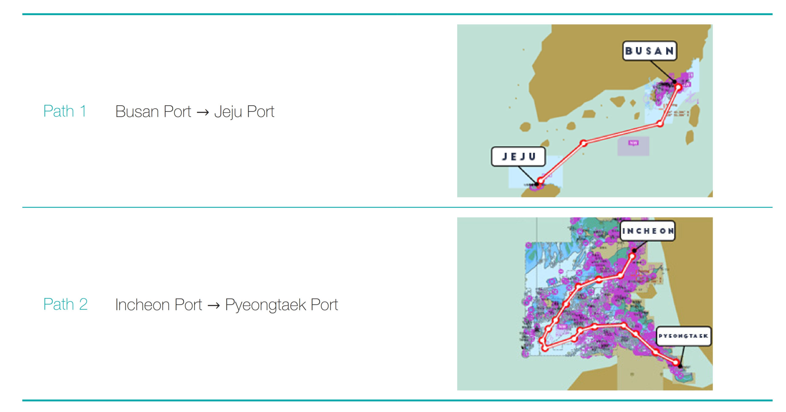
To investigate whether navigation difficulty affected the experimental results, two routes were selected: Busan to Jeju and Incheon to Pyeongtaek (Table 2).
2.4 Experimental design
2.4.1 Independent variables
The independent variable in this study was the work performance method for voyage planning. Detailed levels of selected variables were subdivided according to the equipment used to perform the task. When using the S-57 ECDIS, the assigned task was performed by using the booklet together with the work.
When using the S-100 ECDIS equipped with next-generation hydrographic information, the task was performed while checking the information necessary for navigation tasks within the equipment. Table 3 summarizes the two selected work performance methods.
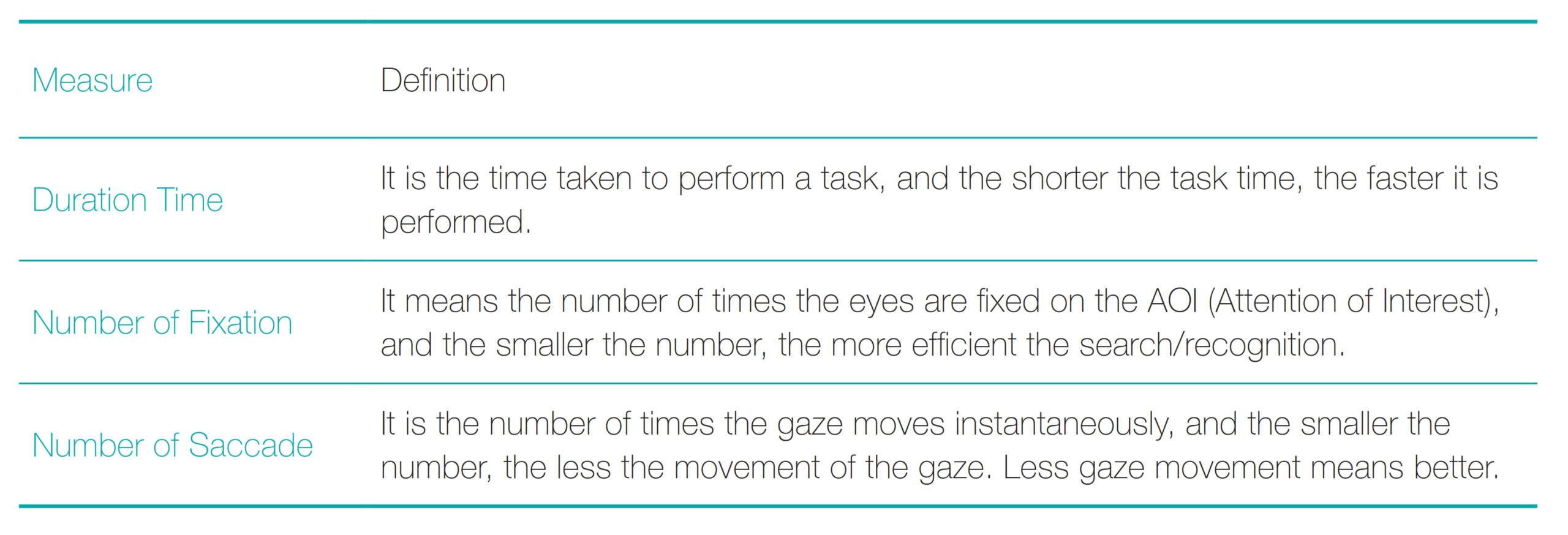
2.4.2 Dependent variables
The dependent variable in this study was the data extracted during the experiments using the eye-tracker: duration time, number of fixations, and number of saccades (Table 4).
2.5 Experimental procedure
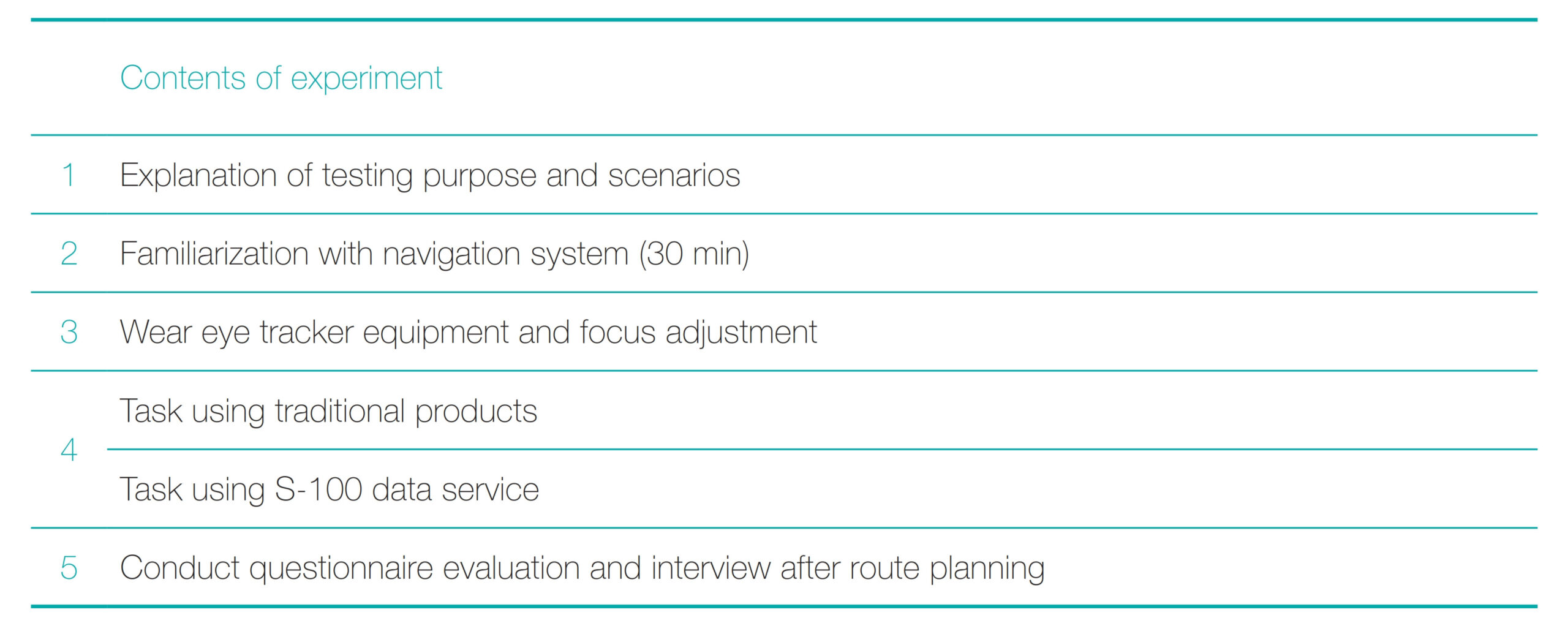
All participants in this experiment were officers with more than three years of sailing experience who held a second-class license. The experiment was divided into five steps (Table 5). Before the participants began the experiment, they received explanations of the purpose of the experiment and the contents of the tasks involved. Then, the participants planned routes from Incheon to Pyeongtaek and from Busan to Jeju using both the S-57 ECDIS and the next-generation S-100 ECDIS. Before the main experiment, they were allowed to familiarize themselves with the equipment for approximately 30 min until they were sufficiently familiar with both types of ECDIS.
After equipping the eye-tracker, they focused their gaze on the monitor screen. The order of the experiment was randomized for the two ECDIS and two routes. The voyage planning tasks were conducted in the following order: introduction to navigation information, confirmation of navigation warnings, voyage planning, confirmation of tide at the destination port, final confirmation of route, and save. After the completion of one voyage planning task, participants were instructed to take 5–10 min rest prior to the next task. After all tasks had been completed, the participants completed a survey and interview to evaluate their use of the S-57 ECDIS and next-generation S-100 ECDIS.
3 Results
The duration time and numbers of fixations and saccades during the experiment were compared using paired t-tests with a significance threshold of 0.05 (p < 0.05). The t-test is the most common statistical method to verify whether the difference in mean between the two groups is significant. After comparison of all data, the data were compared for each task.
3.1 Duration time
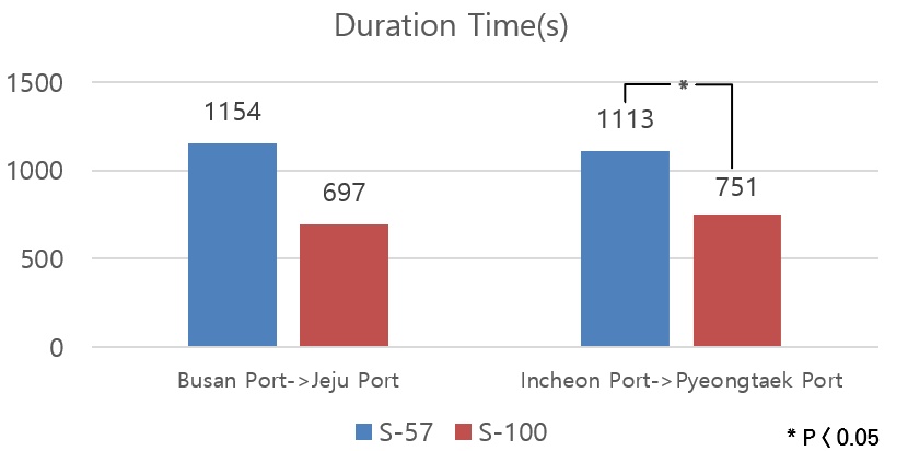
The duration times for the Busan-Jeju Island route using ECDIS based on S-57 and S-100 standards were 1154 s and 697 s, respectively; for the Incheon-Pyeongtaek route, the duration times were 1113 s and 751 s (Fig. 3). For both routes, the S-100 standard-based ECDIS had the shortest duration time, indicating that the task can be performed more rapidly using the S-100 standard-based ECDIS. The difference in duration time for the Incheon-Pyeongtaek route was statistically significant (p < 0.05).
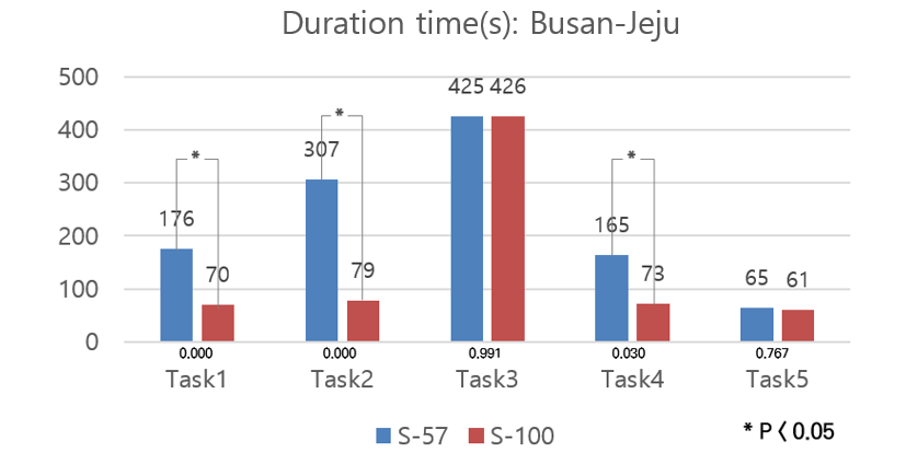
Comparing the data for each task for the Busan-Jeju route, the duration times were significantly (p < 0.05) different for Task 1 (introduction to navigation information), Task 2 (confirmation of navigation warnings), and Task 4 (confirmation of tide at the destination port), indicating that the duration time was significantly shorter when the using S-100 equipment for Tasks 1, 2, and 4 (Fig. 4).
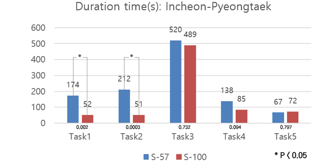
Comparing the data for each task for the Incheon-Pyeongtaek route, the duration times significantly differed (p < 0.05) in Task 1 (introduction to navigation information) and Task 2 (confirmation of navigation warnings); they were significantly shorter when using the S-100 equipment for these tasks (Fig. 5).
3.2 Number of fixation
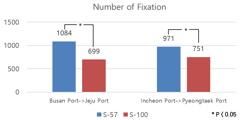
The numbers of fixations on the Busan-Jeju Island route using the ECDIS based on S-57 and S-100 standards were 1084 and 699, respectively; for the Incheon-Pyeongtaek route, these numbers were 971 and 751 (Fig. 6). For both routes, the S-100 standard-based ECDIS had significantly (p < 0.05) fewer fixations, implying that searches were more efficient with the S-100 standard-based ECDIS.
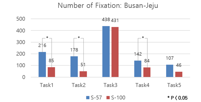
Comparing the data for each task for the Busan-Jeju route, there were significant (p < 0.05) differences in fixation during Task 1 (introduction to navigation information), Task 2 (confirmation of navigation warnings), and Task 4 (confirmation of tide at the destination port) when using S-100 equipment, compared with S-57 equipment (Fig. 7).
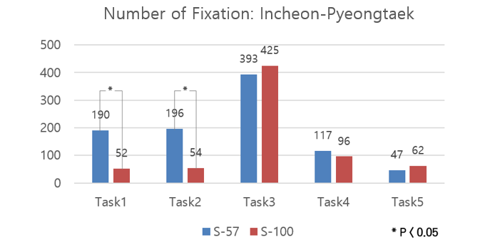
For the Incheon-Pyeongtaek route, the numbers of fixations were significantly (p < 0.05) lower in Task 1 (introduction to navigation information) and Task 2 (confirmation of navigation warnings) when using S-100 equipment (Fig. 8).
3.3 Number of saccade
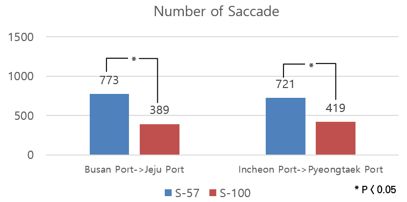
The numbers of saccades on the Busan-Jeju Island route using the ECDIS based on S-57 and S-100 standards were 773 and 389, respectively; for the Incheon-Pyeongtaek route, these numbers were 721 and 419 (Fig. 9). For both routes, the S-100 standard-based ECDIS involved fewer saccades. This finding indicates that the task was performed with less gaze movement when using the S-100 standard ECDIS. The numbers of saccades on the two routes significantly differed (p < 0.05).
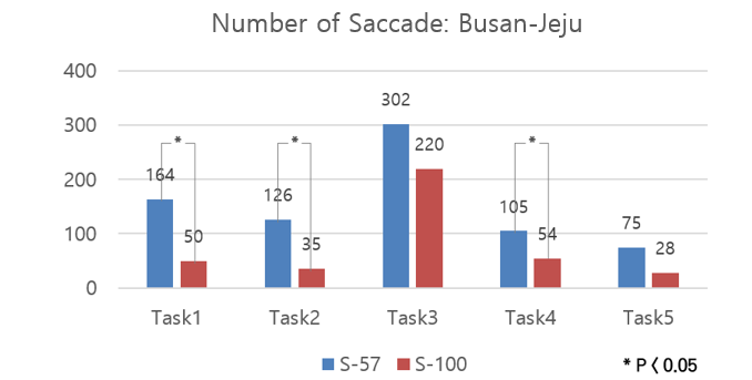
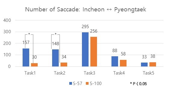
Comparing the data for each task for the Busan-Jeju route (Fig. 10), the number of saccades significantly differed (p < 0.05) for Task 1 (introduction to navigation information), Task 2 (confirmation of navigation warnings), and Task 4 (confirmation of tide at the destination port) when using S-100 equipment, compared with S-57 equipment. Similarly, for the Incheon-Pyeongtaek route (Fig. 11), the number of saccades significantly differed (p < 0.05) for Task 1 (introduction to navigation information) and Task 2 (confirmation of navigation warnings). The results confirmed that the number of saccades was significantly reduced when using S-100 equipment, compared with S-57 equipment, in Tasks 1 and 2.
4 Discussion and conclusion
The IHO has established a contemporary hydrographic geospatial data standard that can support a wide variety of hydrographic-related digital data. The S-57 ECDIS had limitations in representing information; thus, the S-100 standard was introduced. S-100 is fully aligned with mainstream international geospatial standards, particularly the ISO 19100 series of geographic standards, facilitating the integration of hydrographic data and applications into geospatial solutions. Since the introduction of S-100, there has been a need to study how the new standard affects officers’ tasks and ship operations that use ECDIS.
This study investigated ship officers’ visual performance during voyage planning tasks to evaluate the effectiveness of the S-100 ECDIS, capable of ENDS. The results showed that duration times were shorter, and numbers of fixations and saccades were lower, when using the S-100 ECDIS than when using the S-57 ECDIS. These findings imply that the S-100 equipment is more efficient. The S-100 ECDIS displays a large amount of navigation information that is not provided by existing equipment.
Because visual overload is expected with the S-100 equipment, further research is needed regarding screen information volume evaluation and improvement. In terms of ergonomics, the provision of information via symbols (rather than text) facilitates user recognition of information. Further studies are needed to evaluate the intuitiveness of current symbols and to explore the expression of textual information in symbol format.
One of the main advantages of using ECDIS equipped with the S-100 based products is that ships sailing on the sea can explore safe and optimal alternative routes. By sailing on shorter alternative routes, ships can save fuel consumed and reduce CO2 emmisions, which brings not only economic effects but also environmentally positive effects. Since we expect to achieve economic and environmental efficiency in maritime traffic when dynamic hydrographic information is applied to the navigation system. A further study on measuring economic, and ecological efficiency needs to be carried out using S-100 ECDIS and products obtained through this study.
References
Choi, H. S., Kang, D. W., Oh, S. W. and Kim, Y. J. (2021). A Study on Development of Machine-readable Platform for S-100 ECDIS. Journal of Navigation and Port Research, 45(2), 61–68.
Kim, H. S., Mun, C. H and Lee, S. J. (2018). Analysis and Experiment of Portrayal Process Based on S-100 Standard of Marine Safety Information. Journal of Digital Contents Society, 19(7), 1289–1296.
Kim, H. S., Kim, G. H. and Lee, S. J. (2020). Improvement of Maritime Safety Information Symbols for Electronic Navigational Charts. Journal of Digital Contents Society, 21(7), 1355-1364.
Ko, H. J., Oh, S. W., Park, J. M., Suh, S. H. and Jeon, T. B. (2011). A Study on trends of S-100 and S-101 standards and effects. Proceedings of the Korean Institute of Navigation and Port Research Conference, 37–39.
Oh, S. W., Gang, D. U. and Choi H. S. (2017). Development of next-generation hydrographic information test system. Proceedings of the Korean Institute of Navigation and Port Research Conference, 117–120.
Park, J. M., Oh, S. W. and Yu, H. S. (2010). A Study of Integrated Distribution Service System for Electronic Navigational Charts. Journal of Korean Navigation and Port Research, 34(1), 1–8.
Authors’ biographies

Junhyuk Jang is a principal research engineer at the Korea Research Institute of Ships and Ocean Engineering (KRISO). He received his Ph.D. degree from Dong-A University, South Korea. His research interests are ergonomic workplace design and the usability of Navigational systems for maritime safety.

Sekil Park is a principal research scientist at the Korea Research Institute of Ships and Ocean Engineering (KRISO). He received his Ph.D. degree in computer science from Korea Advanced Institute of Science and Technology (KAIST). He has been researching maritime traffic situation awareness, and his research interests include eXtended Reality (XR), simulation, and artificial intelligence.

Sewoong Oh is a principal research engineer at the Korea Research Institute of Ships and Ocean Engineering (KRISO). He received his Ph.D. degree in industry system engineering from Korea Maritime and Ocean University (KMOU), South Korea. He has been researching geospatial standard on maritime data and his research interests include data modeling and maritime service development.

Iji Kim is an international cooperation officer in the Nautical Chart Division of the Korea Hydrographic and Oceanographic Agency, ROK. Ms. Kim holds an MSc degree in Environmental Science from the University of Hohenheim in Stuttgart, Germany. She is Vice-chair of the IHO S-100 Working Group.